Bridge Statistics for Atlantic City, New Jersey (NJ)
Condition, Traffic, Stress, Structural Evaluation, Project Costs
- National Bridge Inventory (NBI) Statistics
- 61Number of bridges
- 1,017ft / 310mTotal length
- $158,614,000Total costs
- 1,310,900Total average daily traffic
- 60,447Total average daily truck traffic
- National Bridge Inventory (NBI) Registered Bridges for Atlantic City
- No street view available for this location
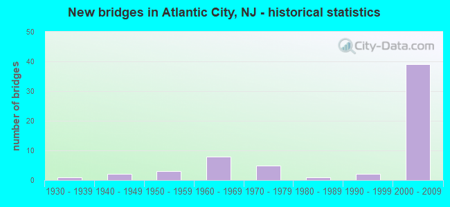
- New bridges - historical statistics
- 11930-1939
- 21940-1949
- 31950-1959
- 81960-1969
- 51970-1979
- 11980-1989
- 21990-1999
- 392000-2009


- Bridge Condition - Deck
- 9.1%Very good
- 57.6%Good
- 21.2%Satisfactory
- 9.1%Fair
- 3.0%Poor

- Bridge Condition - Superstructure
- 9.1%Very good
- 51.5%Good
- 15.2%Satisfactory
- 21.2%Fair
- 3.0%Poor

- Bridge Condition - Substructure
- 45.5%Good
- 33.3%Satisfactory
- 9.1%Fair
- 9.1%Poor
- 3.0%Serious

- Bridge Condition - Channel
- 15.4%Very good
- 76.9%Good
- 7.7%Satisfactory
Find on map >> Show street view
Structure Number: 3500C18, Location: ATLANTIC CITY (Lat: 39.373889, Lng: -74.435831), Route carried "under" structure: Ramp Other road 446X, Year Built: 2001, Structure Length: 0. m, Average Daily Traffic: 5,780 (year 2012), Truck Traffic: 5%, Features Intersected: AC/BC RAMP RC1 & RC2, Facility Carried by Structure: AC/BC NORTHBOUND
Minimum Vertical Clearance: 5.31m (17.42ft), Kilometerpoint: 2.559, Lanes on structure: 3, Lanes under structure: 1, Material/Design: Prestressed concrete, Design/Construction: Stringer/Multi-beam, Length of Maximum Span: 38.7m (127.0ft)
Find on map >> Show street view
Structure Number: 3500C18, Location: ATLANTIC CITY (Lat: 39.373889, Lng: -74.435831), Route carried "under" structure: Ramp Other road 446X, Year Built: 2001, Structure Length: 0. m, Average Daily Traffic: 6,065 (year 2012), Truck Traffic: 5%, Features Intersected: AC/BC RAMP RC1 & RC2, Facility Carried by Structure: AC/BC NORTHBOUND
Minimum Vertical Clearance: 5.11m (16.77ft), Kilometerpoint: 2.559, Lanes on structure: 3, Lanes under structure: 2, Material/Design: Prestressed concrete, Design/Construction: Stringer/Multi-beam, Length of Maximum Span: 38.7m (127.0ft)
Find on map >> Show street view
Structure Number: 3500C19, Location: ATLANTIC CITY (Lat: 39.377781, Lng: -74.436669), Route carried "under" structure: Ramp Other road 446X, Year Built: 2001, Structure Length: 0. m, Average Daily Traffic: 4,410 (year 2012), Truck Traffic: 5%, Features Intersected: HURON AVE. M& RAMP BH1, Facility Carried by Structure: RAMP HM
Minimum Vertical Clearance: 5.41m (17.75ft), Kilometerpoint: 3.122, Lanes on structure: 3, Lanes under structure: 1, Material/Design: Prestressed concrete, Design/Construction: Stringer/Multi-beam, Length of Maximum Span: 28.3m (92.8ft)
Find on map >> Show street view
Structure Number: 3500C19, Location: ATLANTIC CITY (Lat: 39.377781, Lng: -74.436669), Route carried "under" structure: Ramp Other road 446X, Year Built: 2001, Structure Length: 0. m, Average Daily Traffic: 10,475 (year 2012), Truck Traffic: 5%, Features Intersected: HURON AVE. M& RAMP BH1, Facility Carried by Structure: RAMP HM
Minimum Vertical Clearance: 6.45m (21.16ft), Kilometerpoint: 3.122, Lanes on structure: 3, Lanes under structure: 2, Material/Design: Prestressed concrete, Design/Construction: Stringer/Multi-beam, Length of Maximum Span: 28.3m (92.8ft)
Find on map >> Show street view
Structure Number: 3500C19, Location: ATLANTIC CITY (Lat: 39.377781, Lng: -74.436669), Route carried "under" structure: State highway 87, Year Built: 2001, Structure Length: 0. m, Average Daily Traffic: 20,430 (year 2012), Truck Traffic: 4%, Features Intersected: HURON AVE. M& RAMP BH1, Facility Carried by Structure: RAMP HM
Minimum Vertical Clearance: 5.58m (18.31ft), Kilometerpoint: 0.000, Lanes on structure: 3, Lanes under structure: 3, Material/Design: Prestressed concrete, Design/Construction: Stringer/Multi-beam, Length of Maximum Span: 28.3m (92.8ft)
Find on map >> Show street view
Structure Number: 3500C2, Location: ATLANTIC CITY2001 (Lat: 39.377219, Lng: -74.432781), Route carried "under" structure: Ramp Other road 446X, Year Built: 2001, Structure Length: 0. m, Average Daily Traffic: 9,500 (year 2006), Truck Traffic: 5%, Features Intersected: HURON AVE.,RAMP BH1 & MH, Facility Carried by Structure: RAMP 10A
Minimum Vertical Clearance: 5.72m (18.77ft), Kilometerpoint: 3.138, Lanes on structure: 1, Lanes under structure: 2, Material/Design: Prestressed concrete continuous, Design/Construction: Stringer/Multi-beam, Length of Maximum Span: 15.8m (51.8ft)
Find on map >> Show street view
Structure Number: 3500C2, Location: ATLANTIC CITY2001 (Lat: 39.377219, Lng: -74.432781), Route carried "under" structure: Ramp Other road 446X, Year Built: 2001, Structure Length: 0. m, Average Daily Traffic: 5,000 (year 2006), Truck Traffic: 5%, Features Intersected: HURON AVE.,RAMP BH1 & MH, Facility Carried by Structure: RAMP 10A
Minimum Vertical Clearance: 5.26m (17.26ft), Kilometerpoint: 3.138, Lanes on structure: 1, Lanes under structure: 2, Material/Design: Prestressed concrete continuous, Design/Construction: Stringer/Multi-beam, Length of Maximum Span: 15.8m (51.8ft)
Find on map >> Show street view
Structure Number: 3500C21, Location: ATLANTIC CITY (Lat: 39.376939, Lng: -74.432219), Route carried "under" structure: State highway 87, Year Built: 2001, Structure Length: 0. m, Average Daily Traffic: 20,430 (year 2012), Truck Traffic: 5%, Features Intersected: RT. 87 & BRIGANTINE BLVD, Facility Carried by Structure: AC/BC CONNECTOR NB
Minimum Vertical Clearance: 5.03m (16.50ft), Kilometerpoint: 0.000, Lanes on structure: 2, Lanes under structure: 3, Material/Design: Prestressed concrete continuous, Design/Construction: Stringer/Multi-beam, Length of Maximum Span: 40.2m (131.9ft)
Find on map >> Show street view
Structure Number: 3500C21, Location: ATLANTIC CITY (Lat: 39.376939, Lng: -74.432219), Route carried "under" structure: State highway 187, Year Built: 2001, Structure Length: 0. m, Average Daily Traffic: 19,295 (year 2012), Truck Traffic: 4%, Features Intersected: RT. 87 & BRIGANTINE BLVD, Facility Carried by Structure: AC/BC CONNECTOR NB
Minimum Vertical Clearance: 6.91m (22.67ft), Kilometerpoint: 0.000, Lanes on structure: 2, Lanes under structure: 4, Material/Design: Prestressed concrete continuous, Design/Construction: Stringer/Multi-beam, Length of Maximum Span: 40.2m (131.9ft)
Find on map >> Show street view
Structure Number: 4200001, Location: @ MP 0.6 of NJ 87 (Lat: 39.377531, Lng: -74.432139), Route carried "under" structure: Ramp Other road , Year Built: 2003, Structure Length: 0. m, Average Daily Traffic: 540 (year 2020), Features Intersected: (@ NJ 87) Ramp MBH1, Facility Carried by Structure: Ramp HM
Minimum Vertical Clearance: 5.41m (17.75ft), Kilometerpoint: 0.000, Lanes on structure: 3, Lanes under structure: 1, Material/Design: Prestressed concrete, Design/Construction: Stringer/Multi-beam, Length of Maximum Span: 26.5m (86.9ft)
Find on map >> Show street view
Structure Number: 4200002, Location: @ MP 0.6 of NJ 87 (Lat: 39.378311, Lng: -74.432031), Route carried "under" structure: Ramp Other road , Year Built: 2003, Structure Length: 0. m, Average Daily Traffic: 7,040 (year 2020), Features Intersected: Ramp LE - Out, Facility Carried by Structure: Ramps HM and B
Minimum Vertical Clearance: 4.81m (15.78ft), Kilometerpoint: 0.000, Lanes on structure: 3, Lanes under structure: 2, Material/Design: Steel, Design/Construction: Stringer/Multi-beam, Length of Maximum Span: 20.7m (67.9ft)
Find on map >> Show street view
Structure Number: 4200003, Location: Borgata Casino Property (Lat: 39.377861, Lng: -74.433250), Route carried "under" structure: Ramp Other road , Year Built: 2003, Structure Length: 0. m, Average Daily Traffic: 7,040 (year 2020), Features Intersected: Ramp MBH1, Facility Carried by Structure: Ramp HM
Minimum Vertical Clearance: 4.48m (14.70ft), Kilometerpoint: 0.000, Lanes on structure: 1, Lanes under structure: 2, Material/Design: Steel, Design/Construction: Stringer/Multi-beam, Length of Maximum Span: 23.2m (76.1ft)
Find on map >> Show street view
Structure Number: 4200004, Location: Borgata Casino Complex (Lat: 39.377219, Lng: -74.433781), Route carried "under" structure: Ramp Other road , Year Built: 2003, Structure Length: 0. m, Average Daily Traffic: 6,900 (year 2018), Features Intersected: Ramp MBH1, Facility Carried by Structure: Ramp HM
Minimum Vertical Clearance: 3.15m (10.33ft), Kilometerpoint: 0.000, Lanes on structure: 1, Lanes under structure: 1, Material/Design: Concrete, Design/Construction: Stringer/Multi-beam, Length of Maximum Span: 30.8m (101.0ft)