Bridge Statistics for Augusta-Richmond County, Georgia (GA)
Condition, Traffic, Stress, Structural Evaluation, Project Costs
- National Bridge Inventory (NBI) Statistics
- 264Number of bridges
- 4,383ft / 1,336mTotal length
- $687,475,000Total costs
- 4,539,063Total average daily traffic
- 267,581Total average daily truck traffic
- National Bridge Inventory (NBI) Registered Bridges for Augusta-Richmond County
- No street view available for this location
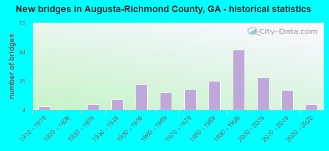
- New bridges - historical statistics
- 31910-1919
- 51930-1939
- 91940-1949
- 221950-1959
- 151960-1969
- 181970-1979
- 251980-1989
- 521990-1999
- 282000-2009
- 172010-2019
- 52020-2022

- Reconstructed bridges - Historical Statistics
- 21960-1969
- 01970-1979
- 101980-1989
- 141990-1999
- 92000-2009


- Bridge Condition - Deck
- 6.8%Very good
- 78.3%Good
- 11.2%Satisfactory
- 3.7%Fair

- Bridge Condition - Superstructure
- 31.7%Very good
- 59.0%Good
- 4.3%Satisfactory
- 3.7%Fair
- 1.2%Poor

- Bridge Condition - Substructure
- 11.2%Very good
- 75.8%Good
- 11.2%Satisfactory
- 1.9%Fair

- Bridge Condition - Channel
- 0.7%Excellent
- 54.7%Very good
- 24.5%Good
- 15.1%Satisfactory
- 3.6%Fair
- 1.4%Poor

- Bridge Condition - Culverts
- 84.2%Good
- 10.5%Satisfactory
- 2.6%Poor
- 2.6%Serious
Find on map >> Show street view
Structure Number: DAPTRAGOR000006, Location: INLET TO WILKENSON LK (Lat: 33.416539, Lng: -82.166511), Route carried "on" structure: Other road , Year Built: 1970, Status: Open, Structure Length: 0.64m (2.10ft), Average Daily Traffic: 500 (year 2015), Average Future Daily Traffic: 600 (year 2041), Features Intersected: COYS CREEK, Facility Carried by Structure: LANE RD
Minimum Vertical Clearance: 30+ m (98+ ft), Kilometerpoint: 0.000, Lanes on structure: 2, Owner: Army, Approaching Roadway Width: 9.6m (31.5ft), Skew: 2 degrees, Material/Design: Steel, Design/Construction: Culvert, Number Of Spans In Main Unit: 2, Length of Maximum Span: 3.0m (9.8ft)
Condition: Channel: Fair, Culverts: Poor, Waterway Adequacy: Equal to present desirable criteria, Approach Roadway Alignment: Equal to present minimum criteria, Length Of Structure Improvement: 1.26m (4.13ft), Designated Inspection Frequency: Every 24 months, Inspection Date: April 2019, Bridge Improvement Cost: $1,000, Roadway Improvement Cost: $1,000, Total Project Cost: $2,000 ( Estimate for 2019)
Find on map >> Show street view
Structure Number: DAPTRAGOR000007, Location: UNION MILL POND EMER OTLT (Lat: 33.324661, Lng: -82.244539), Route carried "on" structure: Other road , Year Built: 2015, Status: Open, Structure Length: 0.87m (2.85ft), Average Daily Traffic: 100 (year 2015), Average Future Daily Traffic: 50 (year 2043), Features Intersected: UNION MILL POND OUTLET, Facility Carried by Structure: MCDUFFIE RD
Minimum Vertical Clearance: 30+ m (98+ ft), Kilometerpoint: 0.000, Lanes on structure: 2, Owner: Army, Approaching Roadway Width: 7.3m (24.0ft), Skew: 2 degrees, Material/Design: Concrete, Design/Construction: Culvert, Number Of Spans In Main Unit: 3, Length of Maximum Span: 2.7m (8.9ft)
Condition: Channel: Good, Culverts: Good, Operating Rating: 54.5 metric tons, Method Used To Determine Operating Rating: Field evaluation and documented engineering judgment, Inventory Rating: 32.7 metric tons, Method Used To Determine Inventory Rating: Field evaluation and documented engineering judgment, Structural Evaluation: Better than present minimum criteria, Waterway Adequacy: High priority of corrective action, Approach Roadway Alignment: Equal to present desirable criteria, Length Of Structure Improvement: 1.02m (3.35ft), Designated Inspection Frequency: Every 24 months, Inspection Date: April 2021, Bridge Improvement Cost: $2,000, Roadway Improvement Cost: $1,000, Total Project Cost: $3,000 ( Estimate for 2021)
Find on map >> Show street view
Structure Number: DAPTRAGOR000008, Location: NEAR GATE 1 (Lat: 33.438861, Lng: -82.118450), Route carried "on" structure: Other road , Year Built: 1996, Status: Open, Structure Length: 2.03m (6.66ft), Average Daily Traffic: 12,500 (year 2015), Truck Traffic: 40%, Average Future Daily Traffic: 13,000 (year 2043), Design Load: HS 20, Features Intersected: BUTLER CREEK TRIB, Facility Carried by Structure: CHAMBERLAIN AVE
Minimum Vertical Clearance: 30+ m (98+ ft), Kilometerpoint: 0.000, Lanes on structure: 7, Owner: Army, Approaching Roadway Width: 29.3m (96.1ft), Material/Design: Concrete, Design/Construction: Culvert, Number Of Spans In Main Unit: 6, Length of Maximum Span: 3.0m (9.8ft)
Condition: Channel: Poor, Culverts: Serious, Operating Rating: 54.5 metric tons, Method Used To Determine Operating Rating: Field evaluation and documented engineering judgment, Inventory Rating: 32.7 metric tons, Method Used To Determine Inventory Rating: Field evaluation and documented engineering judgment, Structural Evaluation: High priority of corrective action, Waterway Adequacy: Equal to present desirable criteria, Approach Roadway Alignment: Equal to present desirable criteria, Length Of Structure Improvement: 2.79m (9.15ft), Designated Inspection Frequency: Every 24 months, Inspection Date: April 2021, Bridge Improvement Cost: $124,000, Roadway Improvement Cost: $1,000, Total Project Cost: $125,000
Find on map >> Show street view
Structure Number: 2450011, Location: 9.1 MI N OF HEPHZIBAH (Lat: 33.450469, Lng: -82.073539), Route carried "under" structure: Interstate 520, Structure Length: 0. m, Average Daily Traffic: 70,200 (year 2011), Truck Traffic: 4%, Features Intersected: SR 10 EBL (US 78), Facility Carried by Structure: SR 10 - US 78
Minimum Vertical Clearance: 5.61m (18.41ft), Kilometerpoint: 4.828, Lanes on structure: 8, Length of Maximum Span: 0.0m
Find on map >> Show street view
Structure Number: 2450016, Location: 12.4 MI NE OF HEPHZIBAH (Lat: 33.461022, Lng: -81.966181), Route carried "under" structure: County highway 475, Structure Length: 0. m, Average Daily Traffic: 15,100 (year 2012), Truck Traffic: 3%, Features Intersected: SR 10 (US 1), Facility Carried by Structure: SR 10 - US 1
Minimum Vertical Clearance: 7.28m (23.88ft), Kilometerpoint: 0.000, Lanes on structure: 6, Length of Maximum Span: 0.0m
Find on map >> Show street view
Structure Number: 2450017, Location: 13.1 MI NE OF HEPHZIBAH (Lat: 33.469269, Lng: -81.958747), Route carried "under" structure: County highway 2496, Structure Length: 0. m, Average Daily Traffic: 3,200 (year 2012), Truck Traffic: 1%, Features Intersected: SR 10 (US 1), Facility Carried by Structure: SR 10 - US 1
Minimum Vertical Clearance: 5.02m (16.47ft), Kilometerpoint: 1.609, Lanes on structure: 4, Length of Maximum Span: 0.0m
Find on map >> Show street view
Structure Number: 2450018, Location: 13.2 MI NE OF HEPHZIBAH (Lat: 33.470489, Lng: -81.958158), Route carried "under" structure: County highway 2495, Structure Length: 0. m, Average Daily Traffic: 4,700 (year 2012), Truck Traffic: 1%, Features Intersected: SR 10 (US 1), Facility Carried by Structure: SR 10 - US 1
Minimum Vertical Clearance: 5.08m (16.67ft), Kilometerpoint: 1.609, Lanes on structure: 5, Length of Maximum Span: 0.0m
Find on map >> Show street view
Structure Number: 2450019, Location: 13.3 MI NE OF HEPHZIBAH (Lat: 33.471425, Lng: -81.957547), Route carried "under" structure: County highway 2494, Structure Length: 0. m, Average Daily Traffic: 1,210 (year 2012), Truck Traffic: 1%, Features Intersected: SR 10 (US 1), Facility Carried by Structure: SR 10 - US 1
Minimum Vertical Clearance: 5.05m (16.57ft), Kilometerpoint: 1.609, Lanes on structure: 5, Length of Maximum Span: 0.0m
Find on map >> Show street view
Structure Number: 245002, Location: 13.4 MI NE OF HEPHZIBAH (Lat: 33.472381, Lng: -81.957050), Route carried "under" structure: State highway 28, Structure Length: 0. m, Average Daily Traffic: 14,820 (year 2009), Truck Traffic: 1%, Features Intersected: SR 10 (US 1), Facility Carried by Structure: SR 10 - US 1
Minimum Vertical Clearance: 4.82m (15.81ft), Kilometerpoint: 6.437, Lanes on structure: 5, Length of Maximum Span: 0.0m
Find on map >> Show street view
Structure Number: 2450021, Location: 13.5 MI NE OF HEPHZIBAH (Lat: 33.475589, Lng: -81.955397), Route carried "under" structure: County highway 2493, Structure Length: 0. m, Average Daily Traffic: 1,210 (year 2012), Truck Traffic: 3%, Features Intersected: SR 10 (US 1), Facility Carried by Structure: SR 10 - US 1
Minimum Vertical Clearance: 5.99m (19.65ft), Kilometerpoint: 0.000, Lanes on structure: 4, Length of Maximum Span: 0.0m
Find on map >> Show street view
Structure Number: 2450022, Location: 13.3 MI NE OF HEPHZIBAH (Lat: 33.471214, Lng: -81.956978), Route carried "under" structure: County highway 2494, Structure Length: 0. m, Average Daily Traffic: 1,210 (year 2012), Truck Traffic: 1%, Features Intersected: SR 10 ENTR RMP TO US 1, Facility Carried by Structure: ENTR RAMP TO US 1/
Minimum Vertical Clearance: 4.74m (15.55ft), Kilometerpoint: 1.609, Lanes on structure: 1, Length of Maximum Span: 0.0m
Find on map >> Show street view
Structure Number: 2450023, Location: 13.3 MI NE OF HEPHZIBAH (Lat: 33.471481, Lng: -81.957800), Route carried "under" structure: County highway 2494, Structure Length: 0. m, Average Daily Traffic: 1,210 (year 2009), Truck Traffic: 1%, Features Intersected: SR 10 ENTR RMP TO US 1, Facility Carried by Structure: US 1 ENTRANCE RMP/
Minimum Vertical Clearance: 4.77m (15.65ft), Kilometerpoint: 1.609, Lanes on structure: 1, Length of Maximum Span: 0.0m
Find on map >> Show street view
Structure Number: 2450033, Location: 7.9 MI NE OF HEPHZIBAH (Lat: 33.401322, Lng: -82.005761), Route carried "under" structure: Ramp Interstate 520, Structure Length: 0. m, Average Daily Traffic: 2,275 (year 2012), Truck Traffic: 15%, Features Intersected: SR 56, Facility Carried by Structure: SR 56
Minimum Vertical Clearance: 5.56m (18.24ft), Kilometerpoint: 14.484, Lanes on structure: 7, Length of Maximum Span: 0.0m
Find on map >> Show street view
Structure Number: 2450033, Location: 7.9 MI NE OF HEPHZIBAH (Lat: 33.401322, Lng: -82.005761), Route carried "under" structure: Interstate 520, Structure Length: 0. m, Average Daily Traffic: 9,100 (year 2005), Truck Traffic: 1%, Features Intersected: SR 56, Facility Carried by Structure: SR 56
Minimum Vertical Clearance: 5.38m (17.65ft), Kilometerpoint: 14.484, Lanes on structure: 7, Length of Maximum Span: 0.0m
Find on map >> Show street view
Structure Number: 2450038, Location: 8.1 MI N OF HEPHZIBAH (Lat: 33.428969, Lng: -82.064700), Route carried "under" structure: Interstate 520, Structure Length: 0. m, Average Daily Traffic: 70,200 (year 2011), Truck Traffic: 5%, Features Intersected: CR 105 GLENN HILLS ROAD, Facility Carried by Structure: GLENN HILLS ROAD
Minimum Vertical Clearance: 5.30m (17.39ft), Kilometerpoint: 8.047, Lanes on structure: 2, Length of Maximum Span: 0.0m
Find on map >> Show street view
Structure Number: 2450049, Location: 14.8 MI N OF HEPHZIBAH (Lat: 33.521628, Lng: -82.031161), Route carried "under" structure: State highway 104, Structure Length: 0. m, Average Daily Traffic: 21,700 (year 2012), Truck Traffic: 5%, Features Intersected: I-20, Facility Carried by Structure: I-20
Minimum Vertical Clearance: 8.33m (27.33ft), Kilometerpoint: 8.047, Lanes on structure: 7, Length of Maximum Span: 0.0m
Find on map >> Show street view
Structure Number: 2450055, Location: 13.9 MI N OF HEPHZIBAH (Lat: 33.512022, Lng: -82.042661), Route carried "under" structure: State highway 28, Structure Length: 0. m, Average Daily Traffic: 46,000 (year 2012), Truck Traffic: 17%, Features Intersected: I-20 RAMP, Facility Carried by Structure: I-20 RAMP
Minimum Vertical Clearance: 5.51m (18.08ft), Kilometerpoint: 16.093, Lanes on structure: 1, Length of Maximum Span: 0.0m
Find on map >> Show street view
Structure Number: 2450057, Location: 10.5 MI N OF HEPHZIBAH (Lat: 33.466736, Lng: -82.083367), Route carried "under" structure: County highway 1501, Structure Length: 0. m, Average Daily Traffic: 33,070 (year 2011), Truck Traffic: 4%, Features Intersected: I-520 (SR 415), Facility Carried by Structure: I-520
Minimum Vertical Clearance: 5.25m (17.22ft), Kilometerpoint: 4.828, Lanes on structure: 6, Length of Maximum Span: 0.0m
Find on map >> Show street view
Structure Number: 2450061, Location: 7.8 MI N OF HEPHZIBAH (Lat: 33.423528, Lng: -82.058992), Route carried "under" structure: US 1, Structure Length: 0. m, Average Daily Traffic: 41,440 (year 2014), Truck Traffic: 4%, Features Intersected: I-520 (SR 415), Facility Carried by Structure: I-520
Minimum Vertical Clearance: 4.87m (15.98ft), Kilometerpoint: 30.578, Lanes on structure: 8, Length of Maximum Span: 0.0m
Find on map >> Show street view
Structure Number: 2450063, Location: 7.4 MI N OF HEPHZIBAH (Lat: 33.407239, Lng: -82.030622), Route carried "under" structure: County highway 65, Structure Length: 0. m, Average Daily Traffic: 17,020 (year 2011), Truck Traffic: 4%, Features Intersected: I-520 (SR 415), Facility Carried by Structure: I-520
Minimum Vertical Clearance: 6.24m (20.47ft), Kilometerpoint: 1.609, Lanes on structure: 5, Length of Maximum Span: 0.0m
Find on map >> Show street view
Structure Number: 2450064, Location: 7.5 MI N OF HEPHZIBAH (Lat: 33.406481, Lng: -82.026728), Route carried "under" structure: US 25, Structure Length: 0. m, Average Daily Traffic: 32,820 (year 2012), Truck Traffic: 8%, Features Intersected: I-520 (SR 415), Facility Carried by Structure: I-520
Minimum Vertical Clearance: 6.32m (20.73ft), Kilometerpoint: 20.921, Lanes on structure: 5, Length of Maximum Span: 0.0m
Find on map >> Show street view
Structure Number: 2450066, Location: 7.7 MI N OF HEPHZIBAH (Lat: 33.402181, Lng: -82.014547), Route carried "under" structure: County highway 273, Structure Length: 0. m, Average Daily Traffic: 3,300 (year 2012), Truck Traffic: 1%, Features Intersected: I-520 (SR 415), Facility Carried by Structure: I-520
Minimum Vertical Clearance: 7.59m (24.90ft), Kilometerpoint: 1.609, Lanes on structure: 7, Length of Maximum Span: 0.0m
Find on map >> Show street view
Structure Number: 2450069, Location: 13 MI N OF HEPHZIBAH (Lat: 33.502611, Lng: -82.061000), Route carried "under" structure: Interstate 20, Structure Length: 0. m, Average Daily Traffic: 59,500 (year 2012), Truck Traffic: 33%, Features Intersected: CR 842 WARREN ROAD, Facility Carried by Structure: WARREN ROAD
Minimum Vertical Clearance: 5.25m (17.22ft), Kilometerpoint: 318.650, Lanes on structure: 2, Length of Maximum Span: 0.0m
Find on map >> Show street view
Structure Number: 2450073, Location: 12.9 MI NE OF HEPHZIBAH (Lat: 33.487067, Lng: -82.006850), Route carried "under" structure: State highway 28, Structure Length: 0. m, Average Daily Traffic: 33,120 (year 2012), Truck Traffic: 15%, Features Intersected: CR 2346 MILLEDGE ROAD, Facility Carried by Structure: MILLEDGE ROAD
Minimum Vertical Clearance: 5.56m (18.24ft), Kilometerpoint: 11.265, Lanes on structure: 2, Length of Maximum Span: 0.0m
Find on map >> Show street view
Structure Number: 2450089, Location: 7.4 MI N OF HEPHZIBAH (Lat: 33.408503, Lng: -82.037389), Route carried "under" structure: Interstate 520, Structure Length: 0. m, Average Daily Traffic: 52,800 (year 2012), Truck Traffic: 10%, Features Intersected: CR 210 RICHMOND HILL RD., Facility Carried by Structure: RICHMOND HILL RD
Minimum Vertical Clearance: 6.55m (21.49ft), Kilometerpoint: 11.265, Lanes on structure: 3, Length of Maximum Span: 0.0m
Find on map >> Show street view
Structure Number: 245009, Location: 9.1 MI NW OF HEPHZIBAH (Lat: 33.445344, Lng: -82.072811), Route carried "under" structure: Interstate 520, Structure Length: 0. m, Average Daily Traffic: 70,200 (year 2011), Truck Traffic: 1%, Features Intersected: CR 145 MILLEDGEVILLE RD, Facility Carried by Structure: MILLEDGEVILLE RD
Minimum Vertical Clearance: 5.38m (17.65ft), Kilometerpoint: 6.437, Lanes on structure: 2, Length of Maximum Span: 0.0m
Find on map >> Show street view
Structure Number: 2450095, Location: 13 MI NE OF HEPHZIBAH (Lat: 33.491514, Lng: -82.009956), Route carried "under" structure: County highway 2398, Structure Length: 0. m, Average Daily Traffic: 1,840 (year 2012), Truck Traffic: 1%, Features Intersected: SR 28, Facility Carried by Structure: SR 28
Minimum Vertical Clearance: 5.05m (16.57ft), Kilometerpoint: 0.000, Lanes on structure: 4, Length of Maximum Span: 0.0m
Find on map >> Show street view
Structure Number: 2450097, Location: 12.9 MI NE OF HEPHZIBAH (Lat: 33.483647, Lng: -81.996872), Route carried "under" structure: County highway 2417, Structure Length: 0. m, Average Daily Traffic: 4,500 (year 2012), Truck Traffic: 1%, Features Intersected: SR 28, Facility Carried by Structure: SR 28
Minimum Vertical Clearance: 5.10m (16.73ft), Kilometerpoint: 1.609, Lanes on structure: 4, Length of Maximum Span: 0.0m
Find on map >> Show street view
Structure Number: 2450098, Location: 12.9 MI NE OF HEPHZIBAH (Lat: 33.482808, Lng: -81.994289), Route carried "under" structure: County highway 2429, Structure Length: 0. m, Average Daily Traffic: 4,270 (year 2012), Truck Traffic: 1%, Features Intersected: SR 28, Facility Carried by Structure: SR 28
Minimum Vertical Clearance: 5.33m (17.49ft), Kilometerpoint: 1.609, Lanes on structure: 4, Length of Maximum Span: 0.0m
Find on map >> Show street view
Structure Number: 2450106, Location: 11.1 MI NE OF HEPHIZIBAH (Lat: 33.459058, Lng: -82.008728), Route carried "under" structure: County highway 1408, Structure Length: 0. m, Average Daily Traffic: 5,210 (year 2012), Truck Traffic: 1%, Features Intersected: CR 1408 - OLIVE ROAD, Facility Carried by Structure: CSX RR (279458A)
Minimum Vertical Clearance: 3.25m (10.66ft), Kilometerpoint: 1.609, Length of Maximum Span: 0.0m
Find on map >> Show street view
Structure Number: 2450107, Location: 12.9 MI NE OF HEPHZIBAH (Lat: 33.476192, Lng: -81.980811), Route carried "under" structure: State highway 4, Structure Length: 0. m, Average Daily Traffic: 14,100 (year 2014), Truck Traffic: 1%, Features Intersected: SR 28, Facility Carried by Structure: SR 28
Minimum Vertical Clearance: 5.08m (16.67ft), Kilometerpoint: 40.234, Lanes on structure: 4, Length of Maximum Span: 0.0m
Find on map >> Show street view
Structure Number: 2450107, Location: 12.9 MI NE OF HEPHZIBAH (Lat: 33.476192, Lng: -81.980811), Route carried "under" structure: County highway 2469, Structure Length: 0. m, Average Daily Traffic: 1,840 (year 2007), Truck Traffic: 1%, Features Intersected: SR 28, Facility Carried by Structure: SR 28
Minimum Vertical Clearance: 6.42m (21.06ft), Kilometerpoint: 0.000, Lanes on structure: 4, Length of Maximum Span: 0.0m
Find on map >> Show street view
Structure Number: 2450107, Location: 12.9 MI NE OF HEPHZIBAH (Lat: 33.476192, Lng: -81.980811), Route carried "under" structure: County highway 1499, Structure Length: 0. m, Average Daily Traffic: 20,100 (year 2005), Truck Traffic: 1%, Features Intersected: SR 28, Facility Carried by Structure: SR 28
Minimum Vertical Clearance: 7.13m (23.39ft), Kilometerpoint: 0.000, Lanes on structure: 4, Length of Maximum Span: 0.0m
Find on map >> Show street view
Structure Number: 2450107, Location: 12.9 MI NE OF HEPHZIBAH (Lat: 33.476192, Lng: -81.980811), Route carried "under" structure: County highway 2466, Structure Length: 0. m, Average Daily Traffic: 13,550 (year 2010), Truck Traffic: 10%, Features Intersected: SR28, Facility Carried by Structure: SR 28
Minimum Vertical Clearance: 7.36m (24.15ft), Kilometerpoint: 1.609, Lanes on structure: 4, Length of Maximum Span: 0.0m
Find on map >> Show street view
Structure Number: 2450112, Location: 12.2 MI NE OF HEPHIZIBAH (Lat: 33.469678, Lng: -81.990239), Route carried "under" structure: County highway 2652, Structure Length: 0. m, Average Daily Traffic: 1,570 (year 2012), Truck Traffic: 1%, Features Intersected: CR 2652 LANEY-WALKER, Facility Carried by Structure: PED OVERPASS
Minimum Vertical Clearance: 7.67m (25.16ft), Kilometerpoint: 0.000, Length of Maximum Span: 0.0m
Find on map >> Show street view
Structure Number: 2450113, Location: 12.9 MI NE OF HEPHIZIBAH (Lat: 33.466950, Lng: -81.965111), Route carried "under" structure: County highway 2483, Structure Length: 0. m, Average Daily Traffic: 1,460 (year 2009), Truck Traffic: 1%, Features Intersected: CR 2509 WALTON WAY, Facility Carried by Structure: WALTON WAY
Minimum Vertical Clearance: 7.11m (23.33ft), Kilometerpoint: 1.609, Lanes on structure: 4, Length of Maximum Span: 0.0m
Find on map >> Show street view
Structure Number: 2450115, Location: 9.5 MI NE OF HEPHZIBAH (Lat: 33.437528, Lng: -82.005542), Route carried "under" structure: US 1, Structure Length: 0. m, Average Daily Traffic: 40,800 (year 2012), Truck Traffic: 12%, Features Intersected: SR 121 (US 25)
Minimum Vertical Clearance: 6.60m (21.65ft), Kilometerpoint: 22.531, Lanes on structure: 3, Length of Maximum Span: 0.0m
Find on map >> Show street view
Structure Number: 2450118, Location: 11.9 MI NE OF HEPHIZBAH (Lat: 33.464719, Lng: -81.994478), Route carried "under" structure: County highway 2649, Structure Length: 0. m, Average Daily Traffic: 28,980 (year 2005), Truck Traffic: 1%, Features Intersected: SR 4, Facility Carried by Structure: SR 4
Minimum Vertical Clearance: 6.60m (21.65ft), Kilometerpoint: 0.000, Lanes on structure: 4, Length of Maximum Span: 0.0m
Find on map >> Show street view
Structure Number: 2450118, Location: 11.9 MI NE OF HEPHIZBAH (Lat: 33.464719, Lng: -81.994478), Route carried "under" structure: County highway 2591, Structure Length: 0. m, Average Daily Traffic: 1,740 (year 2009), Truck Traffic: 1%, Features Intersected: SR 4, Facility Carried by Structure: SR 4
Minimum Vertical Clearance: 7.41m (24.31ft), Kilometerpoint: 0.000, Lanes on structure: 4, Length of Maximum Span: 0.0m
Find on map >> Show street view
Structure Number: 2450125, Location: 14.2 MI N OF HEPHZIBAH (Lat: 33.506408, Lng: -82.000647), Route carried "under" structure: County highway 2480, Structure Length: 0. m, Average Daily Traffic: 860 (year 2012), Truck Traffic: 1%, Features Intersected: SR 104 MURRAY ROAD, Facility Carried by Structure: MURRAY ROAD
Minimum Vertical Clearance: 4.90m (16.08ft), Kilometerpoint: 3.219, Lanes on structure: 4, Length of Maximum Span: 0.0m
Find on map >> Show street view
Structure Number: 245013, Location: 8.9 MI NE OF HEPHZIBAH (Lat: 33.406461, Lng: -81.986011), Route carried "under" structure: Interstate 520, Structure Length: 0. m, Average Daily Traffic: 25,600 (year 2011), Truck Traffic: 15%, Features Intersected: DOUG BARNARD PKWY-NBL, Facility Carried by Structure: DOUG BARNARD PKWY-
Minimum Vertical Clearance: 5.79m (19.00ft), Kilometerpoint: 16.093, Lanes on structure: 2, Length of Maximum Span: 0.0m
Find on map >> Show street view
Structure Number: 2450131, Location: 8.9 MI NE OF HEPHZIBAH (Lat: 33.406339, Lng: -81.986225), Route carried "under" structure: Interstate 520, Structure Length: 0. m, Average Daily Traffic: 25,600 (year 2012), Truck Traffic: 15%, Features Intersected: SR 56 SPUR, Facility Carried by Structure: DOUG BARNARD PKWY-
Minimum Vertical Clearance: 5.63m (18.47ft), Kilometerpoint: 16.093, Lanes on structure: 3, Length of Maximum Span: 0.0m
Find on map >> Show street view
Structure Number: 2455026, Location: 12.4 MI NE OF HEPHZIBAH (Lat: 33.472081, Lng: -81.989172), Route carried "under" structure: County highway 2458, Structure Length: 0. m, Average Daily Traffic: 1,570 (year 2012), Truck Traffic: 1%, Features Intersected: CR 2458 HARPER STREET, Facility Carried by Structure: PED. OVERPASS
Minimum Vertical Clearance: 5.41m (17.75ft), Kilometerpoint: 0.000, Length of Maximum Span: 0.0m
Find on map >> Show street view
Structure Number: 2455032, Location: 12.4 MI NE OF HEPHZIBAH (Lat: 33.471661, Lng: -81.988117), Route carried "under" structure: County highway 2458, Structure Length: 0. m, Average Daily Traffic: 1,570 (year 2012), Truck Traffic: 1%, Features Intersected: CR 2458 HARPER STREET, Facility Carried by Structure: BUILDING
Minimum Vertical Clearance: 4.62m (15.16ft), Kilometerpoint: 0.000, Length of Maximum Span: 0.0m
Find on map >> Show street view
Structure Number: 2455039, Location: 12 MI N OF HEPHZIBAH (Lat: 33.487892, Lng: -82.107900), Route carried "under" structure: Interstate 20, Structure Length: 0. m, Average Daily Traffic: 43,100 (year 2012), Truck Traffic: 11%, Features Intersected: CR 601 WHEELER RD, Facility Carried by Structure: WHEELER ROAD
Minimum Vertical Clearance: 6.12m (20.08ft), Kilometerpoint: 313.822, Lanes on structure: 5, Length of Maximum Span: 0.0m
Find on map >> Show street view
Structure Number: 2455055, Location: 12.5 MI NE OF HEPHZIBAH (Lat: 33.440569, Lng: -81.940828), Route carried "under" structure: Interstate 520, Structure Length: 0. m, Average Daily Traffic: 22,300 (year 2011), Truck Traffic: 12%, Features Intersected: LOVERS LANE, Facility Carried by Structure: LOVERS LANE
Minimum Vertical Clearance: 5.30m (17.39ft), Kilometerpoint: 22.531, Lanes on structure: 2, Length of Maximum Span: 0.0m
Find on map >> Show street view
Structure Number: 2455065, Location: 5.6 MI NW OF HEPHZIBAH (Lat: 33.393864, Lng: -82.116547), Route carried "under" structure: US 1, Structure Length: 0. m, Average Daily Traffic: 26,500 (year 2014), Truck Traffic: 4%, Features Intersected: CR 1503 TOBACCO, Facility Carried by Structure: TOBACCO ROAD
Minimum Vertical Clearance: 5.38m (17.65ft), Kilometerpoint: 22.531, Lanes on structure: 6, Length of Maximum Span: 0.0m
Find on map >> Show street view
Structure Number: 2455068, Location: 13.2 MI NE OF HEPHZIBAH (Lat: 33.452897, Lng: -81.931567), Route carried "under" structure: County highway 475, Structure Length: 0. m, Average Daily Traffic: 19,000 (year 2012), Truck Traffic: 6%, Features Intersected: I-520 SR 415 BOBBY JONES, Facility Carried by Structure: I-520 (EBL)
Minimum Vertical Clearance: 6.57m (21.56ft), Kilometerpoint: 3.219, Lanes on structure: 2, Length of Maximum Span: 0.0m
Find on map >> Show street view
Structure Number: 2455069, Location: 13.2 MI NE OF HEPHZIBAH (Lat: 33.452961, Lng: -81.931808), Route carried "under" structure: County highway 475, Structure Length: 0. m, Average Daily Traffic: 19,000 (year 2012), Truck Traffic: 6%, Features Intersected: I-520 SR 415 BOBBY JONES, Facility Carried by Structure: I-520 (WBL)
Minimum Vertical Clearance: 6.40m (21.00ft), Kilometerpoint: 3.219, Lanes on structure: 2, Length of Maximum Span: 0.0m
Find on map >> Show street view
Structure Number: 245507, Location: 13.4 MI NE OF HEPHZIBAH (Lat: 33.455814, Lng: -81.929647), Route carried "under" structure: State highway 28, Structure Length: 0. m, Average Daily Traffic: 19,800 (year 2012), Truck Traffic: 6%, Features Intersected: I-520 SR 415 BOBBY JONES, Facility Carried by Structure: I-520
Minimum Vertical Clearance: 6.60m (21.65ft), Kilometerpoint: 3.219, Lanes on structure: 4, Length of Maximum Span: 0.0m
Find on map >> Show street view
Structure Number: 2455075, Location: 12.4 MI N OF HEPHZIBAH (Lat: 33.494839, Lng: -82.079939), Route carried "under" structure: Interstate 20, Structure Length: 0. m, Average Daily Traffic: 59,500 (year 2009), Truck Traffic: 12%, Features Intersected: WALTON WAY EXT, Facility Carried by Structure: WALTON WAY EXT / D
Minimum Vertical Clearance: 7.64m (25.07ft), Kilometerpoint: 317.041, Lanes on structure: 4, Length of Maximum Span: 0.0m
Find on map >> Show street view
Structure Number: 2455075, Location: 12.4 MI N OF HEPHZIBAH (Lat: 33.494839, Lng: -82.079939), Route carried "under" structure: Interstate 20, Structure Length: 0. m, Average Daily Traffic: 59,500 (year 2009), Truck Traffic: 12%, Features Intersected: WALTON WAY EXT, Facility Carried by Structure: WALTON WAY EXT / D
Minimum Vertical Clearance: 5.30m (17.39ft), Kilometerpoint: 317.041, Lanes on structure: 4, Length of Maximum Span: 0.0m
Find on map >> Show street view
Structure Number: 2455075, Location: 12.4 MI N OF HEPHZIBAH (Lat: 33.494839, Lng: -82.079939), Route carried "under" structure: Interstate 20, Structure Length: 0. m, Average Daily Traffic: 59,500 (year 2012), Truck Traffic: 16%, Features Intersected: WALTON WAY EXT, Facility Carried by Structure: WALTON WAY EXT / D
Minimum Vertical Clearance: 7.01m (23.00ft), Kilometerpoint: 317.041, Lanes on structure: 4, Length of Maximum Span: 0.0m
Find on map >> Show street view
Structure Number: 2455077, Location: 11.9 MI NW OF HEPHZIBAH (Lat: 33.498478, Lng: -82.086339), Route carried "under" structure: County highway 1, Structure Length: 0. m, Average Daily Traffic: 56,520 (year 2012), Truck Traffic: 7%, Features Intersected: SR 232, Facility Carried by Structure: SR 232
Minimum Vertical Clearance: 5.46m (17.91ft), Kilometerpoint: 0.000, Lanes on structure: 6, Length of Maximum Span: 0.0m
Find on map >> Show street view
Structure Number: 2455078, Location: 11.6 MI NW OF HEPHZIBAH (Lat: 33.483844, Lng: -82.083875), Route carried "under" structure: Interstate 520, Structure Length: 0. m, Average Daily Traffic: 82,500 (year 2011), Truck Traffic: 11%, Features Intersected: CR 601 WHEELER, Facility Carried by Structure: WHEELER ROAD
Minimum Vertical Clearance: 5.25m (17.22ft), Kilometerpoint: 1.609, Lanes on structure: 6, Length of Maximum Span: 0.0m
Find on map >> Show street view
Structure Number: 2455078, Location: 11.6 MI NW OF HEPHZIBAH (Lat: 33.483844, Lng: -82.083875), Route carried "under" structure: Ramp Interstate 520, Structure Length: 0. m, Average Daily Traffic: 82,500 (year 2009), Truck Traffic: 11%, Features Intersected: CR 601 WHEELER, Facility Carried by Structure: WHEELER ROAD
Minimum Vertical Clearance: 6.01m (19.72ft), Kilometerpoint: 1.609, Lanes on structure: 6, Length of Maximum Span: 0.0m
Find on map >> Show street view
Structure Number: 2455078, Location: 11.6 MI NW OF HEPHZIBAH (Lat: 33.483844, Lng: -82.083875), Route carried "under" structure: Ramp Interstate 520, Structure Length: 0. m, Average Daily Traffic: 82,500 (year 2009), Truck Traffic: 11%, Features Intersected: CR 601 WHEELER, Facility Carried by Structure: WHEELER ROAD
Minimum Vertical Clearance: 5.25m (17.22ft), Kilometerpoint: 1.609, Lanes on structure: 6, Length of Maximum Span: 0.0m
Find on map >> Show street view
Structure Number: 2455079, Location: 12.3 MI N OF HEPHZIBAH (Lat: 33.493208, Lng: -82.084139), Route carried "under" structure: Interstate 520, Structure Length: 0. m, Average Daily Traffic: 103,280 (year 2011), Truck Traffic: 11%, Features Intersected: I-520 (SR 415), Facility Carried by Structure: I-20
Minimum Vertical Clearance: 5.20m (17.06ft), Kilometerpoint: 0.000, Lanes on structure: 8, Length of Maximum Span: 0.0m
Find on map >> Show street view
Structure Number: 245508, Location: 13.9 MI N OF HEPHZIBAH (Lat: 33.512086, Lng: -82.043042), Route carried "under" structure: State highway 28, Structure Length: 0. m, Average Daily Traffic: 75,260 (year 2012), Truck Traffic: 9%, Features Intersected: I-20 EBL, Facility Carried by Structure: I-20
Minimum Vertical Clearance: 5.58m (18.31ft), Kilometerpoint: 16.093, Lanes on structure: 8, Length of Maximum Span: 0.0m
Find on map >> Show street view
Structure Number: 2455081, Location: 12.3 MI N OF HEPHZIBAH (Lat: 33.494319, Lng: -82.085342), Route carried "under" structure: Interstate 520, Structure Length: 0. m, Average Daily Traffic: 13,220 (year 2009), Truck Traffic: 17%, Features Intersected: I-20 RAMP, Facility Carried by Structure: I-20 RAMP
Minimum Vertical Clearance: 6.62m (21.72ft), Kilometerpoint: 0.000, Lanes on structure: 2, Length of Maximum Span: 0.0m
Find on map >> Show street view
Structure Number: 2455081, Location: 12.3 MI N OF HEPHZIBAH (Lat: 33.494319, Lng: -82.085342), Route carried "under" structure: Interstate 520, Structure Length: 0. m, Average Daily Traffic: 13,220 (year 2009), Truck Traffic: 17%, Features Intersected: I-20 RAMP, Facility Carried by Structure: I-20 RAMP
Minimum Vertical Clearance: 5.68m (18.64ft), Kilometerpoint: 0.000, Lanes on structure: 2, Length of Maximum Span: 0.0m
Find on map >> Show street view
Structure Number: 2455081, Location: 12.3 MI N OF HEPHZIBAH (Lat: 33.494319, Lng: -82.085342), Route carried "under" structure: Interstate 520, Structure Length: 0. m, Average Daily Traffic: 13,220 (year 2012), Truck Traffic: 17%, Features Intersected: I-20 RAMP, Facility Carried by Structure: I-20 RAMP
Minimum Vertical Clearance: 7.64m (25.07ft), Kilometerpoint: 0.000, Lanes on structure: 2, Length of Maximum Span: 0.0m
Find on map >> Show street view
Structure Number: 2455081, Location: 12.3 MI N OF HEPHZIBAH (Lat: 33.494319, Lng: -82.085342), Route carried "under" structure: Interstate 20, Structure Length: 0. m, Average Daily Traffic: 13,220 (year 2009), Truck Traffic: 17%, Features Intersected: I-20 RAMP
Minimum Vertical Clearance: 6.95m (22.80ft), Kilometerpoint: 315.432, Lanes on structure: 2, Length of Maximum Span: 0.0m
Find on map >> Show street view
Structure Number: 2455081, Location: 12.3 MI N OF HEPHZIBAH (Lat: 33.494319, Lng: -82.085342), Route carried "under" structure: Interstate 520, Structure Length: 0. m, Average Daily Traffic: 13,220 (year 2009), Truck Traffic: 17%, Features Intersected: I-20 RAMP, Facility Carried by Structure: I-20 RAMP
Minimum Vertical Clearance: 6.42m (21.06ft), Kilometerpoint: 0.000, Lanes on structure: 2, Length of Maximum Span: 0.0m
Find on map >> Show street view
Structure Number: 2455081, Location: 12.3 MI N OF HEPHZIBAH (Lat: 33.494319, Lng: -82.085342), Route carried "under" structure: Interstate 20, Structure Length: 0. m, Average Daily Traffic: 13,220 (year 2009), Truck Traffic: 17%, Features Intersected: I-20 RAMP
Minimum Vertical Clearance: 6.55m (21.49ft), Kilometerpoint: 315.432, Lanes on structure: 2, Length of Maximum Span: 0.0m
Find on map >> Show street view
Structure Number: 2455082, Location: 12.2 MI N OF HEPHZIBAH (Lat: 33.494025, Lng: -82.083553), Route carried "under" structure: Interstate 520, Structure Length: 0. m, Average Daily Traffic: 10,940 (year 2012), Truck Traffic: 17%, Features Intersected: I-520 RAMP
Minimum Vertical Clearance: 11.12m (36.48ft), Kilometerpoint: 1.609, Lanes on structure: 2, Length of Maximum Span: 0.0m
Find on map >> Show street view
Structure Number: 2455082, Location: 12.2 MI N OF HEPHZIBAH (Lat: 33.494025, Lng: -82.083553), Route carried "under" structure: Interstate 520, Structure Length: 0. m, Average Daily Traffic: 10,940 (year 2009), Truck Traffic: 17%, Features Intersected: I-520 RAMP
Minimum Vertical Clearance: 6.93m (22.74ft), Kilometerpoint: 317.041, Lanes on structure: 2, Length of Maximum Span: 0.0m
Find on map >> Show street view
Structure Number: 2455086, Location: 12.9 MI NE OF HEPHIZIBAH (Lat: 33.483575, Lng: -81.985131), Route carried "under" structure: State highway 104, Structure Length: 0. m, Average Daily Traffic: 5,520 (year 2012), Truck Traffic: 2%, Features Intersected: CR 3799, Facility Carried by Structure: GREENE STREET
Minimum Vertical Clearance: 7.74m (25.39ft), Kilometerpoint: 1.609, Lanes on structure: 2, Length of Maximum Span: 0.0m