Bridge Statistics for Aurora, Illinois (IL)
Condition, Traffic, Stress, Structural Evaluation, Project Costs
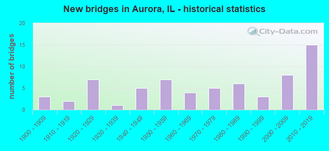
- New bridges - historical statistics
- 31900-1909
- 21910-1919
- 71920-1929
- 11930-1939
- 51940-1949
- 71950-1959
- 41960-1969
- 51970-1979
- 61980-1989
- 31990-1999
- 82000-2009
- 152010-2019

- Reconstructed bridges - Historical Statistics
- 11970-1979
- 41980-1989
- 71990-1999
- 52000-2009
- 22010-2019


- Bridge Condition - Deck
- 2.7%Excellent
- 21.6%Very good
- 27.0%Good
- 32.4%Satisfactory
- 16.2%Fair

- Bridge Condition - Superstructure
- 2.3%Excellent
- 27.3%Very good
- 31.8%Good
- 25.0%Satisfactory
- 11.4%Fair
- 2.3%Poor

- Bridge Condition - Substructure
- 36.4%Very good
- 34.1%Good
- 20.5%Satisfactory
- 9.1%Fair

- Bridge Condition - Channel
- 4.9%Excellent
- 19.5%Very good
- 24.4%Good
- 31.7%Satisfactory
- 17.1%Fair
- 2.4%Poor

- Bridge Condition - Culverts
- 37.5%Good
- 50.0%Satisfactory
- 12.5%Poor
Find on map >> Show street view
Structure Number: 456015, Location: 0.3 MI NW US RTE 34 (Lat: 41.735403, Lng: -88.263083), Route carried "on" structure: City street , Year Built: 1977, Year Reconstructed: 2021, Status: Open, Structure Length: 1.25m (4.10ft), Average Daily Traffic: 9,550 (year 2018), Truck Traffic: 4%, Average Future Daily Traffic: 9,550 (year 2032), Design Load: HS 25 or greater, Features Intersected: WAUBONSIE CREEK, Facility Carried by Structure: MONTGOMERY ROAD
Minimum Vertical Clearance: 30+ m (98+ ft), Kilometerpoint: 0.241, Lanes on structure: 2, Owner: City or Municipal Highway Agency, Approaching Roadway Width: 11.6m (38.1ft), Skew: 20 degrees, Material/Design: Prestressed concrete, Design/Construction: Box Beam or Girders - Multiple, Number Of Spans In Main Unit: 1, Length of Maximum Span: 12.0m (39.4ft), Curb or Sidewalk Widths: Left: 4.7m (15.4ft), Right: 4.7m (15.4ft), Curb-To-Curb Width: 11.6m (38.1ft), Out-to-Out Width: 21.7m (71.2ft)
Condition: Deck: Excellent, Superstructure: Excellent, Substructure: Very good, Channel: Satisfactory, Operating Rating: 53.8 metric tons, Method Used To Determine Operating Rating: Load and Resistance Factor Rating (LRFR) rating reported by rating factor(RF) method using HL-93 loadings, Inventory Rating: 41.5 metric tons, Method Used To Determine Inventory Rating: Load and Resistance Factor Rating (LRFR) rating reported by rating factor(RF) method using HL-93 loadings, Structural Evaluation: Equal to present desirable criteria, Deck Geometry: Somewhat better than minimum adequacy, Waterway Adequacy: Superior to present desirable criteria, Approach Roadway Alignment: Equal to present desirable criteria, Designated Inspection Frequency: Every 12 months, Inspection Date: October 2021, Deck Structure Type: Concrete Precast Panels, Wearing Surface/Protective System: Wearing Surface: Integral Concrete, Deck Protection: Epoxy Coated Reinforcing
Find on map >> Show street view
Structure Number: 456016, Location: .05MI E OF FARNSWRTH (Lat: 41.782386, Lng: -88.281044), Route carried "on" structure: City street , Year Built: 2005, Status: Open, Structure Length: 1.66m (5.45ft), Average Daily Traffic: 14,700 (year 2018), Truck Traffic: 5%, Average Future Daily Traffic: 8,932 (year 2032), Design Load: HS 20, Features Intersected: INDIAN CREEK, Facility Carried by Structure: INDIAN TRAIL ROAD
Minimum Vertical Clearance: 30+ m (98+ ft), Kilometerpoint: 0.064, Lanes on structure: 6, Base Highway Network: Yes (Inventory Route: 1157000, Subroute: 80), Owner: City or Municipal Highway Agency, Approaching Roadway Width: 14.0m (45.9ft), Skew: 31 degrees, Material/Design: Concrete, Design/Construction: Culvert, Number Of Spans In Main Unit: 5, Length of Maximum Span: 3.3m (10.8ft), Curb or Sidewalk Widths: Left: 1.5m (4.9ft), Right: 1.5m (4.9ft), Curb-To-Curb Width: 22.7m (74.5ft), Out-to-Out Width: 30.5m (100.1ft)
Condition: Channel: Satisfactory, Culverts: Good, Operating Rating: 62.9 metric tons, Method Used To Determine Operating Rating: Load Factor (LF) rating reported by rating factor (RF) method using MS18 loading, Inventory Rating: 37.6 metric tons, Method Used To Determine Inventory Rating: Load Factor (LF) rating reported by rating factor (RF) method using MS18 loading, Structural Evaluation: Better than present minimum criteria, Deck Geometry: Meets minimum limits, Waterway Adequacy: Superior to present desirable criteria, Approach Roadway Alignment: Equal to present desirable criteria, Designated Inspection Frequency: Every 48 months, Inspection Date: October 2020
Find on map >> Show street view
Structure Number: 456017, Location: 1.1 Mi S E Indian Tr (Lat: 41.766353, Lng: -88.301944), Route carried "on" structure: City street , Year Built: 1986, Status: Open, Structure Length: 18.24m (59.84ft), Average Daily Traffic: 9,000 (year 2018), Truck Traffic: 7%, Average Future Daily Traffic: 649 (year 2032), Design Load: HS 20, Features Intersected: B+N RR & INDIAN CR., Facility Carried by Structure: HIGH STREET
Minimum Vertical Clearance: 30+ m (98+ ft), Kilometerpoint: 1.722, Lanes on structure: 2, Owner: City or Municipal Highway Agency, Approaching Roadway Width: 9.1m (29.9ft), Skew: 2 degrees, Material/Design: Steel continuous, Design/Construction: Stringer/Multi-beam, Number Of Spans In Main Unit: 4, Length of Maximum Span: 64.0m (210.0ft), Curb or Sidewalk Widths: Left: 1.5m (4.9ft), Right: 1.5m (4.9ft), Curb-To-Curb Width: 9.1m (29.9ft), Out-to-Out Width: 13.9m (45.6ft)
Condition: Deck: Satisfactory, Superstructure: Satisfactory, Substructure: Satisfactory, Channel: Satisfactory, Operating Rating: 53.8 metric tons, Method Used To Determine Operating Rating: Assigned rating based on Load Factor Design (LFD) reported by rating factor (RF) using MS18 loading, Inventory Rating: 32.4 metric tons, Method Used To Determine Inventory Rating: Assigned rating based on Load Factor Design (LFD) reported by rating factor (RF) using MS18 loading, Structural Evaluation: Equal to present minimum criteria, Deck Geometry: Meets minimum limits, Underclear: Somewhat better than minimum adequacy, Waterway Adequacy: Superior to present desirable criteria, Approach Roadway Alignment: Equal to present desirable criteria, Designated Inspection Frequency: Every 24 months, Inspection Date: May 2021, Deck Structure Type: Concrete Cast-file-Place, Wearing Surface/Protective System: Deck Protection: Epoxy Coated Reinforcing
Find on map >> Show street view
Structure Number: 456022, Location: 1000FT W OF OHIO ST (Lat: 41.767500, Lng: -88.295514), Route carried "on" structure: City street , Year Built: 2009, Status: Open, Structure Length: 8.53m (27.99ft), Average Daily Traffic: 275 (year 2018), Truck Traffic: 13%, Average Future Daily Traffic: 394 (year 2032), Design Load: HS 25 or greater, Features Intersected: BNSF AND INDIAN CR, Facility Carried by Structure: WOOD STREET
Minimum Vertical Clearance: 30+ m (98+ ft), Kilometerpoint: 0.451, Lanes on structure: 2, Owner: City or Municipal Highway Agency, Approaching Roadway Width: 8.2m (26.9ft), Skew: 1 degrees, Material/Design: Steel continuous, Design/Construction: Stringer/Multi-beam, Number Of Spans In Main Unit: 3, Length of Maximum Span: 39.6m (129.9ft), Curb or Sidewalk Widths: Left: 1.5m (4.9ft), Right: 1.5m (4.9ft), Curb-To-Curb Width: 8.2m (26.9ft), Out-to-Out Width: 11.9m (39.0ft)
Condition: Deck: Satisfactory, Superstructure: Good, Substructure: Good, Channel: Satisfactory, Operating Rating: 44.1 metric tons, Method Used To Determine Operating Rating: Assigned rating based on Load Factor Design (LFD) reported by rating factor (RF) using MS18 loading, Inventory Rating: 32.4 metric tons, Method Used To Determine Inventory Rating: Assigned rating based on Load Factor Design (LFD) reported by rating factor (RF) using MS18 loading, Structural Evaluation: Better than present minimum criteria, Deck Geometry: Somewhat better than minimum adequacy, Underclear: Superior to present desirable criteria, Waterway Adequacy: Superior to present desirable criteria, Approach Roadway Alignment: Meets minimum limits, Designated Inspection Frequency: Every 24 months, Inspection Date: May 2021, Deck Structure Type: Concrete Cast-file-Place, Wearing Surface/Protective System: Deck Protection: Epoxy Coated Reinforcing
Find on map >> Show street view
Structure Number: 456027, Location: 0.3 MI S SHEFFER RD (Lat: 41.773439, Lng: -88.281689), Route carried "on" structure: Other road , Year Built: 2018, Status: Open, Structure Length: 1.99m (6.53ft), Average Daily Traffic: 24,000 (year 2018), Truck Traffic: 6%, Average Future Daily Traffic: 29,858 (year 2032), Design Load: HS 25 or greater, Features Intersected: Indian Creek, Facility Carried by Structure: FAP-360 Frnswrth A
Minimum Vertical Clearance: 30+ m (98+ ft), Kilometerpoint: 42.872, Lanes on structure: 5, Base Highway Network: Yes, Owner: City or Municipal Highway Agency, Approaching Roadway Width: 18.0m (59.1ft), Material/Design: Prestressed concrete, Design/Construction: Box Beam or Girders - Multiple, Number Of Spans In Main Unit: 1, Length of Maximum Span: 18.9m (62.0ft), Curb or Sidewalk Widths: Left: 2.0m (6.6ft), Right: 3.0m (9.8ft), Curb-To-Curb Width: 18.0m (59.1ft), Out-to-Out Width: 23.9m (78.4ft)
Condition: Deck: Good, Superstructure: Very good, Substructure: Very good, Channel: Excellent, Operating Rating: 42.1 metric tons, Method Used To Determine Operating Rating: Assigned ratings based on Load and Resistance Factor Design (LRFD) reported by rating factor (RF) using HL93 loadings, Inventory Rating: 32.4 metric tons, Method Used To Determine Inventory Rating: Assigned ratings based on Load and Resistance Factor Design (LRFD) reported by rating factor (RF) using HL93 loadings, Structural Evaluation: Equal to present desirable criteria, Deck Geometry: High priority of replacement, Waterway Adequacy: Superior to present desirable criteria, Approach Roadway Alignment: Equal to present desirable criteria, Designated Inspection Frequency: Every 48 months, Inspection Date: October 2020, Deck Structure Type: Concrete Precast Panels, Wearing Surface/Protective System: Wearing Surface: Integral Concrete, Deck Protection: Epoxy Coated Reinforcing
Find on map >> Show street view
Structure Number: 456052, Location: 2 MI S OF I-88 (Lat: 41.770353, Lng: -88.282392), Route carried "on" structure: Other road , Year Built: 1978, Status: Open, Structure Length: 26.01m (85.33ft), Average Daily Traffic: 24,000 (year 2018), Truck Traffic: 6%, Average Future Daily Traffic: 29,858 (year 2032), Design Load: HS 20, Features Intersected: BN RR, Facility Carried by Structure: FARNSWORTH AVE
Minimum Vertical Clearance: 30+ m (98+ ft), Kilometerpoint: 43.194, Lanes on structure: 4, Base Highway Network: Yes, Owner: City or Municipal Highway Agency, Approaching Roadway Width: 16.7m (54.8ft), Skew: 20 degrees, Material/Design: Steel continuous, Design/Construction: Stringer/Multi-beam, Number Of Spans In Main Unit: 3, Number Of Approach Spans: 8, Length of Maximum Span: 36.9m (121.1ft), Curb or Sidewalk Widths: Left: 0.0m, Right: 1.5m (4.9ft), Curb-To-Curb Width: 17.3m (56.8ft), Out-to-Out Width: 20.7m (67.9ft)
Condition: Deck: Satisfactory, Superstructure: Fair, Substructure: Fair, Operating Rating: 53.8 metric tons, Method Used To Determine Operating Rating: Assigned rating based on Load Factor Design (LFD) reported by rating factor (RF) using MS18 loading, Inventory Rating: 32.4 metric tons, Method Used To Determine Inventory Rating: Assigned rating based on Load Factor Design (LFD) reported by rating factor (RF) using MS18 loading, Structural Evaluation: Somewhat better than minimum adequacy, Deck Geometry: Somewhat better than minimum adequacy, Underclear: Superior to present desirable criteria, Approach Roadway Alignment: Equal to present desirable criteria, Designated Inspection Frequency: Every 24 months, Inspection Date: May 2021, Deck Structure Type: Concrete Cast-file-Place, Wearing Surface/Protective System: Deck Protection: Epoxy Coated Reinforcing
Find on map >> Show street view
Structure Number: 456053, Location: .1M E. Farnsworth (Lat: 41.777811, Lng: -88.279789), Route carried "on" structure: Other road , Year Built: 2016, Status: Open, Structure Length: 1.32m (4.33ft), Average Daily Traffic: 3,200 (year 2018), Truck Traffic: 7%, Average Future Daily Traffic: 1,404 (year 2032), Design Load: HS 25 or greater, Features Intersected: Indian Creek, Facility Carried by Structure: Sheffer Road
Minimum Vertical Clearance: 30+ m (98+ ft), Kilometerpoint: 0.161, Lanes on structure: 2, Owner: City or Municipal Highway Agency, Approaching Roadway Width: 10.9m (35.8ft), Material/Design: Prestressed concrete, Design/Construction: Box Beam or Girders - Multiple, Number Of Spans In Main Unit: 1, Length of Maximum Span: 12.2m (40.0ft), Curb-To-Curb Width: 11.3m (37.1ft), Out-to-Out Width: 12.3m (40.4ft)
Condition: Deck: Very good, Superstructure: Very good, Substructure: Very good, Channel: Very good, Operating Rating: 42.1 metric tons, Method Used To Determine Operating Rating: Assigned ratings based on Load and Resistance Factor Design (LRFD) reported by rating factor (RF) using HL93 loadings, Inventory Rating: 32.4 metric tons, Method Used To Determine Inventory Rating: Assigned ratings based on Load and Resistance Factor Design (LRFD) reported by rating factor (RF) using HL93 loadings, Structural Evaluation: Equal to present desirable criteria, Deck Geometry: Somewhat better than minimum adequacy, Waterway Adequacy: Superior to present desirable criteria, Approach Roadway Alignment: Equal to present desirable criteria, Designated Inspection Frequency: Every 48 months, Inspection Date: November 2018, Deck Structure Type: Concrete Precast Panels, Wearing Surface/Protective System: Wearing Surface: Integral Concrete, Deck Protection: Epoxy Coated Reinforcing
Find on map >> Show street view
Structure Number: 459127, Location: 0.41 MI E OHIO ST (Lat: 41.769950, Lng: -88.283394), Route carried "on" structure: County highway , Year Built: 2019, Status: Open, Structure Length: 2.55m (8.37ft), Average Daily Traffic: 1,700 (year 2018), Truck Traffic: 6%, Average Future Daily Traffic: 2,567 (year 2039), Design Load: HS 25 or greater, Features Intersected: INDIAN CREEK, Facility Carried by Structure: RURAL STREET
Minimum Vertical Clearance: 30+ m (98+ ft), Kilometerpoint: 0.161, Lanes on structure: 2, Owner: Town or Township Highway Agency, Approaching Roadway Width: 11.0m (36.1ft), Skew: 1 degrees, Material/Design: Prestressed concrete, Design/Construction: Box Beam or Girders - Multiple, Number Of Spans In Main Unit: 3, Length of Maximum Span: 11.2m (36.7ft), Curb-To-Curb Width: 11.0m (36.1ft), Out-to-Out Width: 11.0m (36.1ft)
Condition: Deck: Good, Superstructure: Very good, Substructure: Very good, Channel: Very good, Operating Rating: 67.4 metric tons, Method Used To Determine Operating Rating: Load and Resistance Factor Rating (LRFR) rating reported by rating factor(RF) method using HL-93 loadings, Inventory Rating: 52.2 metric tons, Method Used To Determine Inventory Rating: Load and Resistance Factor Rating (LRFR) rating reported by rating factor(RF) method using HL-93 loadings, Structural Evaluation: Equal to present desirable criteria, Deck Geometry: Equal to present minimum criteria, Waterway Adequacy: Equal to present desirable criteria, Approach Roadway Alignment: Equal to present desirable criteria, Designated Inspection Frequency: Every 48 months, Inspection Date: May 2021, Deck Structure Type: Concrete Precast Panels, Wearing Surface/Protective System: Wearing Surface: Integral Concrete, Deck Protection: Epoxy Coated Reinforcing
Find on map >> Show street view
Structure Number: 459914, Location: I-88 3.3M W ILL 25 (Lat: 41.795244, Lng: -88.379453), Route carried "on" structure: Other road , Year Built: 1958, Status: Open, Structure Length: 7.19m (23.59ft), Average Daily Traffic: 6,950 (year 2018), Truck Traffic: 2%, Average Future Daily Traffic: 3,318 (year 2032), Design Load: HS 20, Features Intersected: I-88 E-W TOLL RD., Facility Carried by Structure: DEERPATH ROAD
Minimum Vertical Clearance: 30+ m (98+ ft), Kilometerpoint: 8.256, Lanes on structure: 2, Lanes under structure: 4, Owner: State Toll Authority, Approaching Roadway Width: 7.6m (24.9ft), Skew: 2 degrees, Material/Design: Prestressed concrete, Design/Construction: Stringer/Multi-beam, Number Of Spans In Main Unit: 4, Length of Maximum Span: 21.3m (69.9ft), Curb or Sidewalk Widths: Left: 0.6m (2.0ft), Right: 0.6m (2.0ft), Curb-To-Curb Width: 7.3m (24.0ft), Out-to-Out Width: 8.2m (26.9ft)
Condition: Deck: Satisfactory, Superstructure: Fair, Substructure: Satisfactory, Operating Rating: 69.0 metric tons, Method Used To Determine Operating Rating: Load Factor (LF) rating reported by rating factor (RF) method using MS18 loading, Inventory Rating: 41.5 metric tons, Method Used To Determine Inventory Rating: Load Factor (LF) rating reported by rating factor (RF) method using MS18 loading, Structural Evaluation: Somewhat better than minimum adequacy, Deck Geometry: High priority of replacement, Underclear: Meets minimum limits, Approach Roadway Alignment: Equal to present desirable criteria, Length Of Structure Improvement: 7.92m (25.98ft), Designated Inspection Frequency: Every 24 months, Inspection Date: August 2020, Bridge Improvement Cost: $561,000, Roadway Improvement Cost: $56,000, Total Project Cost: $842,000, Deck Structure Type: Concrete Cast-file-Place, Wearing Surface/Protective System: Wearing Surface: Bituminous
Find on map >> Show street view
Structure Number: 459935, Location: 0.8 M E. of Il. 25 (Lat: 41.797292, Lng: -88.301311), Route carried "on" structure: Other road , Year Built: 2015, Status: Open, Structure Length: 7.86m (25.79ft), Average Daily Traffic: 9,900 (year 2018), Truck Traffic: 5%, Average Future Daily Traffic: 9,442 (year 2032), Design Load: HS 25 or greater, Features Intersected: I-88_REAGAN_MEM_TOLL, Facility Carried by Structure: Mitchell Road
Minimum Vertical Clearance: 30+ m (98+ ft), Kilometerpoint: 6.019, Lanes on structure: 2, Lanes under structure: 4, Owner: Town or Township Highway Agency, Approaching Roadway Width: 12.2m (40.0ft), Material/Design: Concrete continuous, Design/Construction: Stringer/Multi-beam, Number Of Spans In Main Unit: 2, Length of Maximum Span: 39.3m (128.9ft), Curb-To-Curb Width: 12.2m (40.0ft), Out-to-Out Width: 13.2m (43.3ft)
Condition: Deck: Very good, Superstructure: Good, Substructure: Very good, Operating Rating: 43.1 metric tons, Method Used To Determine Operating Rating: Load and Resistance Factor Rating (LRFR) rating reported by rating factor(RF) method using HL-93 loadings, Inventory Rating: 33.0 metric tons, Method Used To Determine Inventory Rating: Load and Resistance Factor Rating (LRFR) rating reported by rating factor(RF) method using HL-93 loadings, Structural Evaluation: Better than present minimum criteria, Deck Geometry: Somewhat better than minimum adequacy, Underclear: Meets minimum limits, Approach Roadway Alignment: Equal to present desirable criteria, Designated Inspection Frequency: Every 24 months, Inspection Date: September 2020, Deck Structure Type: Concrete Cast-file-Place, Wearing Surface/Protective System: Deck Protection: Epoxy Coated Reinforcing
Find on map >> Show street view
Structure Number: 459942, Location: 0.8MI E OF IL 25 (Lat: 41.768247, Lng: -88.291311), Route carried "on" structure: City street , Year Built: 2016, Status: Open, Structure Length: 10.54m (34.58ft), Average Daily Traffic: 10,900 (year 2018), Truck Traffic: 5%, Average Future Daily Traffic: 14,000 (year 2030), Design Load: HS 25 or greater, Features Intersected: BNSF RR & Indian Crk, Facility Carried by Structure: MS-4087 (Ohio St)
Minimum Vertical Clearance: 30+ m (98+ ft), Kilometerpoint: 0.853, Lanes on structure: 2, Owner: City or Municipal Highway Agency, Approaching Roadway Width: 9.1m (29.9ft), Skew: 1 degrees, Material/Design: Steel continuous, Design/Construction: Stringer/Multi-beam, Number Of Spans In Main Unit: 3, Length of Maximum Span: 43.3m (142.1ft), Curb or Sidewalk Widths: Left: 3.5m (11.5ft), Right: 1.8m (5.9ft), Curb-To-Curb Width: 9.1m (29.9ft), Out-to-Out Width: 15.6m (51.2ft)
Condition: Deck: Good, Superstructure: Very good, Substructure: Good, Channel: Fair, Operating Rating: 42.1 metric tons, Method Used To Determine Operating Rating: Assigned ratings based on Load and Resistance Factor Design (LRFD) reported by rating factor (RF) using HL93 loadings, Inventory Rating: 32.4 metric tons, Method Used To Determine Inventory Rating: Assigned ratings based on Load and Resistance Factor Design (LRFD) reported by rating factor (RF) using HL93 loadings, Structural Evaluation: Better than present minimum criteria, Deck Geometry: Meets minimum limits, Underclear: Superior to present desirable criteria, Waterway Adequacy: Superior to present desirable criteria, Approach Roadway Alignment: Meets minimum limits, Designated Inspection Frequency: Every 24 months, Inspection Date: May 2021, Deck Structure Type: Concrete Cast-file-Place, Wearing Surface/Protective System: Deck Protection: Epoxy Coated Reinforcing
Find on map >> Show street view
Structure Number: 459945, Location: 1.8 Mi E. of Ill. 25 (Lat: 41.798431, Lng: -88.282061), Route carried "on" structure: Other road , Year Built: 2016, Status: Open, Structure Length: 8.24m (27.03ft), Average Daily Traffic: 23,500 (year 2014), Truck Traffic: 6%, Average Future Daily Traffic: 29,858 (year 2032), Design Load: HS 25 or greater, Features Intersected: I-88, Facility Carried by Structure: Farnsworth Avenue
Minimum Vertical Clearance: 30+ m (98+ ft), Kilometerpoint: 40.055, Lanes on structure: 5, Lanes under structure: 8, Base Highway Network: Yes, Owner: State Toll Authority, Approaching Roadway Width: 26.8m (87.9ft), Skew: 20 degrees, Material/Design: Prestressed concrete continuous, Design/Construction: Stringer/Multi-beam, Number Of Spans In Main Unit: 2, Length of Maximum Span: 40.6m (133.2ft), Curb or Sidewalk Widths: Left: 3.0m (9.8ft), Right: 0.0m, Curb-To-Curb Width: 26.8m (87.9ft), Out-to-Out Width: 35.4m (116.1ft)
Condition: Deck: Good, Superstructure: Very good, Substructure: Very good, Operating Rating: 45.4 metric tons, Method Used To Determine Operating Rating: Load and Resistance Factor Rating (LRFR) rating reported by rating factor(RF) method using HL-93 loadings, Inventory Rating: 35.0 metric tons, Method Used To Determine Inventory Rating: Load and Resistance Factor Rating (LRFR) rating reported by rating factor(RF) method using HL-93 loadings, Structural Evaluation: Equal to present desirable criteria, Deck Geometry: Superior to present desirable criteria, Approach Roadway Alignment: Equal to present desirable criteria, Designated Inspection Frequency: Every 24 months, Inspection Date: August 2019, Deck Structure Type: Concrete Cast-file-Place, Wearing Surface/Protective System: Deck Protection: Epoxy Coated Reinforcing
Find on map >> Show street view
Structure Number: 459949, Location: 1.5 Mi. E. Fox River (Lat: 41.798319, Lng: -88.289489), Route carried "on" structure: Other road , Year Built: 2014, Status: Open, Structure Length: 8.25m (27.07ft), Average Daily Traffic: 8,000 (year 2018), Truck Traffic: 3%, Average Future Daily Traffic: 9,315 (year 2032), Design Load: HS 25 or greater, Features Intersected: I-88, Facility Carried by Structure: Church Road
Minimum Vertical Clearance: 30+ m (98+ ft), Kilometerpoint: 1.674, Lanes on structure: 2, Lanes under structure: 6, Owner: Town or Township Highway Agency, Approaching Roadway Width: 12.2m (40.0ft), Skew: 1 degrees, Material/Design: Concrete continuous, Design/Construction: Stringer/Multi-beam, Number Of Spans In Main Unit: 2, Length of Maximum Span: 40.6m (133.2ft), Curb-To-Curb Width: 12.2m (40.0ft), Out-to-Out Width: 13.1m (43.0ft)
Condition: Deck: Very good, Superstructure: Very good, Substructure: Very good, Operating Rating: 42.4 metric tons, Method Used To Determine Operating Rating: Load and Resistance Factor Rating (LRFR) rating reported by rating factor(RF) method using HL-93 loadings, Inventory Rating: 32.7 metric tons, Method Used To Determine Inventory Rating: Load and Resistance Factor Rating (LRFR) rating reported by rating factor(RF) method using HL-93 loadings, Structural Evaluation: Equal to present desirable criteria, Deck Geometry: Somewhat better than minimum adequacy, Underclear: Somewhat better than minimum adequacy, Approach Roadway Alignment: Equal to present desirable criteria, Designated Inspection Frequency: Every 24 months, Inspection Date: August 2019, Deck Structure Type: Concrete Cast-file-Place, Wearing Surface/Protective System: Deck Protection: Epoxy Coated Reinforcing
Find on map >> Show street view
Structure Number: 45995, Location: .8 M W DUPAGE CO. (Lat: 41.798669, Lng: -88.277814), Route carried "on" structure: Interstate 88, Year Built: 1958, Status: Open, Structure Length: 0.82m (2.69ft), Average Daily Traffic: 42,750 (year 2020), Truck Traffic: 22%, Average Future Daily Traffic: 58,887 (year 2032), Features Intersected: CREEK
Minimum Vertical Clearance: 30+ m (98+ ft), Kilometerpoint: 191.893, Lanes on structure: 4, Base Highway Network: Yes, Toll: On toll road, Owner: State Toll Authority, Approaching Roadway Width: 39.6m (129.9ft), Material/Design: Concrete continuous, Design/Construction: Culvert, Number Of Spans In Main Unit: 2, Length of Maximum Span: 3.7m (12.1ft)
Condition: Channel: Satisfactory, Culverts: Satisfactory, Operating Rating: 68.0 metric tons, Method Used To Determine Operating Rating: Load Factor (LF) rating reported by rating factor (RF) method using MS18 loading, Inventory Rating: 40.8 metric tons, Method Used To Determine Inventory Rating: Load Factor (LF) rating reported by rating factor (RF) method using MS18 loading, Structural Evaluation: Equal to present minimum criteria, Waterway Adequacy: Equal to present desirable criteria, Approach Roadway Alignment: Equal to present desirable criteria, Designated Inspection Frequency: Every 24 months, Inspection Date: August 2019, Deck Structure Type: Concrete Cast-file-Place
Find on map >> Show street view
Structure Number: 220128, Location: 05 MI W OF RTE 59 (Lat: 41.820717, Lng: -88.215511), Route carried "under" structure: State highway 56, Year Built: 1941, Structure Length: 0. m, Average Daily Traffic: 21,500 (year 2021), Truck Traffic: 7%, Features Intersected: ILL 56, Facility Carried by Structure: EJ&E RR
Minimum Vertical Clearance: 4.32m (14.17ft), Kilometerpoint: 22.434, Lanes under structure: 2, Design/Construction: Stringer/Multi-beam, Length of Maximum Span: 15.2m (49.9ft)
Find on map >> Show street view
Structure Number: 229906, Location: 2.5M W. IL 59 (Lat: 41.800894, Lng: -88.240125), Route carried "under" structure: Interstate 88, Year Built: 1958, Structure Length: 0. m, Average Daily Traffic: 102,100 (year 2020), Truck Traffic: 22%, Features Intersected: I-88 E-W TOLL RD., Facility Carried by Structure: EOLA ROAD
Minimum Vertical Clearance: 4.52m (14.83ft), Kilometerpoint: 195.079, Lanes on structure: 4, Lanes under structure: 6, Material/Design: Prestressed concrete, Design/Construction: Stringer/Multi-beam, Length of Maximum Span: 20.5m (67.3ft)
Find on map >> Show street view
Structure Number: 450062, Location: JUST E OF IL 31 (Lat: 41.757428, Lng: -88.310667), Route carried "under" structure: Other road , Year Built: 1900, Structure Length: 0. m, Average Daily Traffic: 12,300 (year 2018), Truck Traffic: 4%, Features Intersected: NEW YORK ST, Facility Carried by Structure: CB B E RR
Minimum Vertical Clearance: 4.85m (15.91ft), Kilometerpoint: 1.481, Lanes under structure: 4, Material/Design: Concrete continuous, Design/Construction: Slab, Length of Maximum Span: 7.3m (24.0ft)
Find on map >> Show street view
Structure Number: 450064, Location: 3 M N OF US 30 (Lat: 41.754339, Lng: -88.315561), Route carried "under" structure: State highway 25, Year Built: 1900, Structure Length: 0. m, Average Daily Traffic: 9,700 (year 2021), Truck Traffic: 3%, Features Intersected: ILL 25, Facility Carried by Structure: CB & O RR
Minimum Vertical Clearance: 4.19m (13.75ft), Kilometerpoint: 8.803, Lanes under structure: 4, Material/Design: Concrete, Length of Maximum Span: 36.6m (120.1ft)
Find on map >> Show street view
Structure Number: 450067, Location: 1.6 MI N OF US 30 (Lat: 41.746131, Lng: -88.336211), Route carried "under" structure: State highway 31, Year Built: 1961, Structure Length: 0. m, Average Daily Traffic: 16,800 (year 2021), Truck Traffic: 11%, Features Intersected: ILL 31 (LAKE ST), Facility Carried by Structure: B.N.RR
Minimum Vertical Clearance: 4.37m (14.34ft), Kilometerpoint: 7.290, Lanes under structure: 2, Material/Design: Concrete, Length of Maximum Span: 11.3m (37.1ft)
Find on map >> Show street view
Structure Number: 45007, Location: AURORA E OF FOX R. (Lat: 41.756608, Lng: -88.312042), Route carried "under" structure: Other road , Year Built: 1900, Structure Length: 0. m, Average Daily Traffic: 10,850 (year 2018), Truck Traffic: 5%, Features Intersected: GALENA BLVD, Facility Carried by Structure: CB & O RR
Minimum Vertical Clearance: 3.99m (13.09ft), Kilometerpoint: 13.277, Lanes under structure: 4, Material/Design: Concrete continuous, Design/Construction: Slab, Length of Maximum Span: 8.2m (26.9ft)
Find on map >> Show street view
Structure Number: 453121, Location: 3 MI W RT 31 (Lat: 41.794850, Lng: -88.375547), Route carried "under" structure: Interstate 88, Year Built: 1985, Structure Length: 0. m, Average Daily Traffic: 67,000 (year 2020), Truck Traffic: 22%, Features Intersected: I-88 E.W. TOLLWAY, Facility Carried by Structure: ORCHARD RD
Minimum Vertical Clearance: 4.95m (16.24ft), Kilometerpoint: 183.734, Lanes on structure: 2, Lanes under structure: 4, Material/Design: Steel continuous, Design/Construction: Stringer/Multi-beam, Length of Maximum Span: 37.7m (123.7ft)
Find on map >> Show street view
Structure Number: 453152, Location: 2 MI. N. OF US 30 (Lat: 41.750608, Lng: -88.375828), Route carried "under" structure: Other road , Year Built: 2001, Structure Length: 0. m, Average Daily Traffic: 34,900 (year 2018), Truck Traffic: 8%, Features Intersected: ORCHARD RD, Facility Carried by Structure: BNSF RAILROAD
Minimum Vertical Clearance: 4.42m (14.50ft), Kilometerpoint: 46.428, Lanes under structure: 4, Material/Design: Steel, Design/Construction: Stringer/Multi-beam, Length of Maximum Span: 14.3m (46.9ft)
Find on map >> Show street view
Structure Number: 453153, Location: 2 MI. N. OF US 30 (Lat: 41.750753, Lng: -88.375828), Route carried "under" structure: Other road , Year Built: 2001, Structure Length: 0. m, Average Daily Traffic: 34,900 (year 2018), Truck Traffic: 8%, Features Intersected: ORCHARD, Facility Carried by Structure: BNSF RAILROAD
Minimum Vertical Clearance: 4.42m (14.50ft), Kilometerpoint: 46.412, Lanes under structure: 4, Material/Design: Steel, Design/Construction: Stringer/Multi-beam, Length of Maximum Span: 14.3m (46.9ft)
Find on map >> Show street view
Structure Number: 456021, Location: .6M SO OF PRAIRIE ST (Lat: 41.751186, Lng: -88.375828), Route carried "under" structure: Other road , Year Built: 2001, Structure Length: 0. m, Average Daily Traffic: 34,900 (year 2018), Truck Traffic: 8%, Features Intersected: ORCHARD ROAD, Facility Carried by Structure: BIKE PATH
Minimum Vertical Clearance: 30+ m (98+ ft), Kilometerpoint: 46.364, Lanes under structure: 4, Length of Maximum Span: 0.0m
Find on map >> Show street view
Structure Number: 459914, Location: I-88 3.3M W ILL 25 (Lat: 41.794781, Lng: -88.379728), Route carried "under" structure: Interstate 88, Year Built: 1958, Structure Length: 0. m, Average Daily Traffic: 55,600 (year 2020), Truck Traffic: 22%, Features Intersected: I-88 E-W TOLL RD., Facility Carried by Structure: DEERPATH ROAD
Minimum Vertical Clearance: 4.65m (15.26ft), Kilometerpoint: 183.412, Lanes on structure: 2, Lanes under structure: 4, Material/Design: Prestressed concrete, Design/Construction: Stringer/Multi-beam, Length of Maximum Span: 21.3m (69.9ft)
Find on map >> Show street view
Structure Number: 459935, Location: 0.8 M E. of Il. 25 (Lat: 41.797292, Lng: -88.301311), Route carried "under" structure: Interstate 88, Year Built: 2015, Structure Length: 0. m, Average Daily Traffic: 81,200 (year 2020), Truck Traffic: 22%, Features Intersected: I-88_REAGAN_MEM_TOLL, Facility Carried by Structure: Mitchell Road
Minimum Vertical Clearance: 4.65m (15.26ft), Kilometerpoint: 189.962, Lanes on structure: 2, Lanes under structure: 4, Material/Design: Concrete continuous, Design/Construction: Stringer/Multi-beam, Length of Maximum Span: 39.3m (128.9ft)
Find on map >> Show street view
Structure Number: 459945, Location: 1.8 Mi E. of Ill. 25 (Lat: 41.798431, Lng: -88.282061), Route carried "under" structure: Interstate 88, Year Built: 2016, Structure Length: 0. m, Average Daily Traffic: 85,500 (year 2020), Truck Traffic: 22%, Features Intersected: I-88, Facility Carried by Structure: Farnsworth Avenue
Minimum Vertical Clearance: 5.03m (16.50ft), Kilometerpoint: 191.571, Lanes on structure: 5, Lanes under structure: 8, Material/Design: Prestressed concrete continuous, Design/Construction: Stringer/Multi-beam, Length of Maximum Span: 40.6m (133.2ft)
Find on map >> Show street view
Structure Number: 459949, Location: 1.5 Mi. E. Fox River (Lat: 41.797989, Lng: -88.289600), Route carried "under" structure: Interstate 88, Year Built: 2014, Structure Length: 0. m, Average Daily Traffic: 81,200 (year 2020), Truck Traffic: 22%, Features Intersected: I-88, Facility Carried by Structure: Church Road
Minimum Vertical Clearance: 5.00m (16.40ft), Kilometerpoint: 190.960, Lanes on structure: 2, Lanes under structure: 6, Material/Design: Concrete continuous, Design/Construction: Stringer/Multi-beam, Length of Maximum Span: 40.6m (133.2ft)