Bridge Statistics for Balch Springs, Texas (TX)
Condition, Traffic, Stress, Structural Evaluation, Project Costs
- National Bridge Inventory (NBI) Statistics
- 80Number of bridges
- 1,801ft / 549mTotal length
- $958,000Total costs
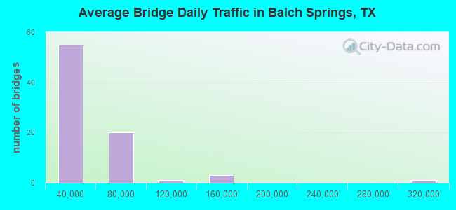
- 2,502,201Total average daily traffic
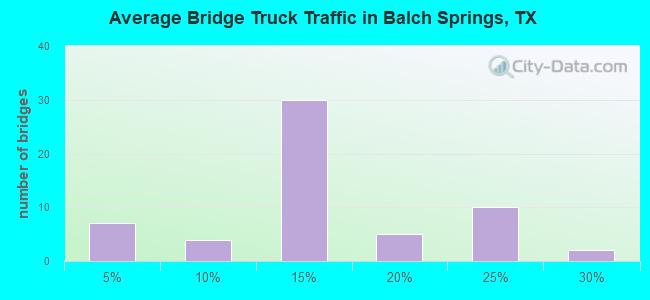
- 355,561Total average daily truck traffic
- National Bridge Inventory (NBI) Registered Bridges for Balch Springs
- No street view available for this location
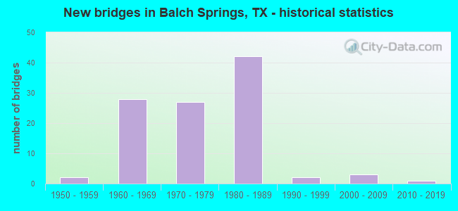
- New bridges - historical statistics
- 21950-1959
- 211960-1969
- 131970-1979
- 381980-1989
- 21990-1999
- 32000-2009
- 12010-2019
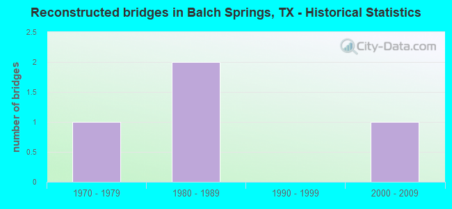
- Reconstructed bridges - Historical Statistics
- 11970-1979
- 21980-1989
- 01990-1999
- 12000-2009
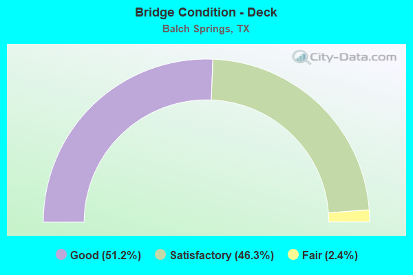
- Bridge Condition - Deck
- 51.2%Good
- 46.3%Satisfactory
- 2.4%Fair
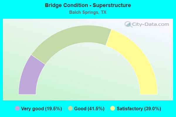
- Bridge Condition - Superstructure
- 19.5%Very good
- 41.5%Good
- 39.0%Satisfactory
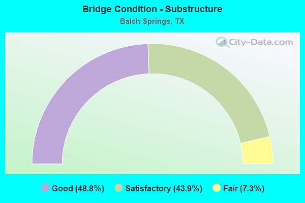
- Bridge Condition - Substructure
- 48.8%Good
- 43.9%Satisfactory
- 7.3%Fair
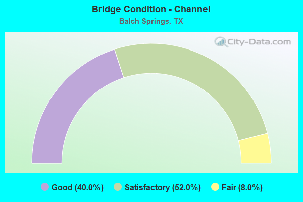
- Bridge Condition - Channel
- 40.0%Good
- 52.0%Satisfactory
- 8.0%Fair
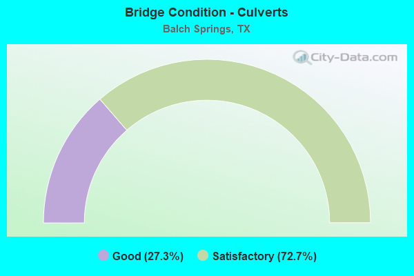
- Bridge Condition - Culverts
- 27.3%Good
- 72.7%Satisfactory
Find on map >> Show street view
Structure Number: 180570N00060002, Location: 0.3 MI S OF RYLIE CREST (Lat: 32.695731, Lng: -96.622178), Route carried "on" structure: City street , Year Built: 2002, Status: Open, Structure Length: 1.28m (4.20ft), Average Daily Traffic: 1,100 (year 2011), Truck Traffic: 2%, Average Future Daily Traffic: 60 (year 2031), Design Load: HS 20, Features Intersected: HICKORY CREEK, Facility Carried by Structure: ARROWDELL RD
Minimum Vertical Clearance: 30+ m (98+ ft), Kilometerpoint: 0.435, Lanes on structure: 2, Owner: City or Municipal Highway Agency, Approaching Roadway Width: 6.1m (20.0ft), Material/Design: Concrete, Design/Construction: Culvert, Number Of Spans In Main Unit: 4, Length of Maximum Span: 3.0m (9.8ft), Curb-To-Curb Width: 8.3m (27.2ft), Out-to-Out Width: 9.0m (29.5ft)
Condition: Channel: Satisfactory, Culverts: Satisfactory, Operating Rating: 54.4 metric tons, Method Used To Determine Operating Rating: Assigned rating based on Load Factor Design (LFD) reported in metric tons, Inventory Rating: 32.7 metric tons, Method Used To Determine Inventory Rating: Assigned rating based on Load Factor Design (LFD) reported in metric tons, Structural Evaluation: Equal to present minimum criteria, Deck Geometry: Meets minimum limits, Waterway Adequacy: Meets minimum limits, Approach Roadway Alignment: Equal to present desirable criteria, Designated Inspection Frequency: Every 24 months, Inspection Date: January 2021, Deck Structure Type: Concrete Cast-file-Place, Wearing Surface/Protective System: Wearing Surface: Bituminous
Find on map >> Show street view
Structure Number: 180570N00500001, Location: 0.45 MI S OF ELAM RD (Lat: 32.712586, Lng: -96.622658), Route carried "on" structure: City street , Year Built: 1958, Status: Open, Structure Length: 0.85m (2.79ft), Average Daily Traffic: 1,983 (year 2019), Average Future Daily Traffic: 2,500 (year 2031), Features Intersected: HICKORY CREEK TRIB, Facility Carried by Structure: HICKORY TREE RD
Minimum Vertical Clearance: 30+ m (98+ ft), Kilometerpoint: 3.315, Lanes on structure: 2, Owner: City or Municipal Highway Agency, Approaching Roadway Width: 7.3m (24.0ft), Skew: 2 degrees, Material/Design: Concrete, Design/Construction: Culvert, Number Of Spans In Main Unit: 3, Length of Maximum Span: 2.4m (7.9ft), Curb-To-Curb Width: 7.6m (24.9ft), Out-to-Out Width: 18.1m (59.4ft)
Condition: Channel: Satisfactory, Culverts: Satisfactory, Operating Rating: 32.7 metric tons, Method Used To Determine Operating Rating: Field evaluation and documented engineering judgment, Inventory Rating: 24.5 metric tons, Method Used To Determine Inventory Rating: Field evaluation and documented engineering judgment, Structural Evaluation: Equal to present minimum criteria, Deck Geometry: Meets minimum limits, Waterway Adequacy: Better than present minimum criteria, Approach Roadway Alignment: Equal to present desirable criteria, Designated Inspection Frequency: Every 24 months, Inspection Date: January 2021, Deck Structure Type: Concrete Cast-file-Place, Wearing Surface/Protective System: Wearing Surface: Bituminous
Find on map >> Show street view
Structure Number: 180570N00595001, Location: 1.00 MI W OF IH 635 (Lat: 32.734075, Lng: -96.629264), Route carried "on" structure: City street , Year Built: 1951, Year Reconstructed: 1970, Status: Open, Structure Length: 1.52m (4.99ft), Average Daily Traffic: 11,150 (year 2011), Truck Traffic: 2%, Average Future Daily Traffic: 15,000 (year 2031), Features Intersected: HICKORY CREEK, Facility Carried by Structure: LAKE JUNE RD
Minimum Vertical Clearance: 30+ m (98+ ft), Kilometerpoint: 1.798, Lanes on structure: 6, Owner: City or Municipal Highway Agency, Approaching Roadway Width: 20.1m (65.9ft), Skew: 20 degrees, Material/Design: Concrete continuous, Design/Construction: Slab, Number Of Spans In Main Unit: 2, Length of Maximum Span: 7.3m (24.0ft), Curb or Sidewalk Widths: Left: 1.7m (5.6ft), Right: 1.7m (5.6ft), Curb-To-Curb Width: 20.1m (65.9ft), Out-to-Out Width: 28.3m (92.8ft)
Condition: Deck: Satisfactory, Superstructure: Satisfactory, Substructure: Satisfactory, Channel: Fair, Operating Rating: 32.7 metric tons, Method Used To Determine Operating Rating: Field evaluation and documented engineering judgment, Inventory Rating: 24.5 metric tons, Method Used To Determine Inventory Rating: Field evaluation and documented engineering judgment, Structural Evaluation: Equal to present minimum criteria, Deck Geometry: High priority of replacement, Waterway Adequacy: Equal to present minimum criteria, Approach Roadway Alignment: Equal to present desirable criteria, Length Of Structure Improvement: 1.52m (4.99ft), Designated Inspection Frequency: Every 24 months, Inspection Date: January 2021, Bridge Improvement Cost: $7,000, Roadway Improvement Cost: $2,000, Total Project Cost: $9,000, Deck Structure Type: Concrete Cast-file-Place
Find on map >> Show street view
Structure Number: 180570N00595007, Location: 0.5 MI SW OF BRUTON RD (Lat: 32.742550, Lng: -96.600569), Route carried "on" structure: City street , Year Built: 2004, Status: Open, Structure Length: 7.62m (25.00ft), Average Daily Traffic: 11,150 (year 2011), Truck Traffic: 15%, Average Future Daily Traffic: 15,000 (year 2031), Design Load: HS 20, Features Intersected: S MESQUITE CREEK TRIB, Facility Carried by Structure: BELT LINE RD
Minimum Vertical Clearance: 30+ m (98+ ft), Kilometerpoint: 1.920, Lanes on structure: 6, Base Highway Network: Yes, Owner: City or Municipal Highway Agency, Approaching Roadway Width: 24.4m (80.1ft), Skew: 20 degrees, Material/Design: Prestressed concrete, Design/Construction: Stringer/Multi-beam, Number Of Spans In Main Unit: 3, Length of Maximum Span: 25.9m (85.0ft), Curb or Sidewalk Widths: Left: 1.3m (4.3ft), Right: 1.3m (4.3ft), Curb-To-Curb Width: 24.4m (80.1ft), Out-to-Out Width: 32.6m (107.0ft)
Condition: Deck: Good, Superstructure: Very good, Substructure: Good, Channel: Good, Operating Rating: 54.4 metric tons, Method Used To Determine Operating Rating: Assigned rating based on Load Factor Design (LFD) reported in metric tons, Inventory Rating: 32.7 metric tons, Method Used To Determine Inventory Rating: Assigned rating based on Load Factor Design (LFD) reported in metric tons, Structural Evaluation: Better than present minimum criteria, Deck Geometry: Somewhat better than minimum adequacy, Waterway Adequacy: Superior to present desirable criteria, Approach Roadway Alignment: Equal to present desirable criteria, Length Of Structure Improvement: 3.35m (10.99ft), Designated Inspection Frequency: Every 24 months, Inspection Date: January 2021, Bridge Improvement Cost: $6,000, Roadway Improvement Cost: $2,000, Total Project Cost: $8,000, Deck Structure Type: Concrete Precast Panels
Find on map >> Show street view
Structure Number: 180570N00668001, Location: 0.50 MI NE of Belt Line (Lat: 32.717250, Lng: -96.580486), Route carried "on" structure: City street , Year Built: 1990, Status: Open, Structure Length: 0.82m (2.69ft), Average Daily Traffic: 3,500 (year 2021), Truck Traffic: 2%, Average Future Daily Traffic: 4,900 (year 2041), Features Intersected: S Mesquite Creek Trib, Facility Carried by Structure: Mercury Rd
Minimum Vertical Clearance: 30+ m (98+ ft), Kilometerpoint: 0.805, Lanes on structure: 4, Owner: City or Municipal Highway Agency, Approaching Roadway Width: 14.0m (45.9ft), Skew: 23 degrees, Material/Design: Concrete, Design/Construction: Culvert, Number Of Spans In Main Unit: 3, Length of Maximum Span: 2.1m (6.9ft)
Condition: Channel: Satisfactory, Culverts: Satisfactory, Operating Rating: 32.7 metric tons, Method Used To Determine Operating Rating: Field evaluation and documented engineering judgment, Inventory Rating: 24.5 metric tons, Method Used To Determine Inventory Rating: Field evaluation and documented engineering judgment, Structural Evaluation: Equal to present minimum criteria, Waterway Adequacy: Equal to present minimum criteria, Approach Roadway Alignment: Equal to present desirable criteria, Designated Inspection Frequency: Every 24 months, Inspection Date: June 2021
Find on map >> Show street view
Structure Number: 180570N00855001, Location: 0.55 MI S of Elam Rd (Lat: 32.711228, Lng: -96.605483), Route carried "on" structure: City street , Year Built: 1985, Status: Open, Structure Length: 1.37m (4.49ft), Average Daily Traffic: 7,100 (year 2021), Truck Traffic: 2%, Average Future Daily Traffic: 9,950 (year 2041), Features Intersected: Hickory Creek Trib, Facility Carried by Structure: Pioneer Rd
Minimum Vertical Clearance: 30+ m (98+ ft), Kilometerpoint: 0.885, Lanes on structure: 4, Owner: City or Municipal Highway Agency, Approaching Roadway Width: 14.6m (47.9ft), Skew: 23 degrees, Material/Design: Concrete, Design/Construction: Culvert, Number Of Spans In Main Unit: 4, Length of Maximum Span: 2.7m (8.9ft), Curb or Sidewalk Widths: Left: 2.2m (7.2ft), Right: 2.2m (7.2ft), Curb-To-Curb Width: 17.0m (55.8ft), Out-to-Out Width: 23.8m (78.1ft)
Condition: Channel: Good, Culverts: Satisfactory, Operating Rating: 32.7 metric tons, Method Used To Determine Operating Rating: Field evaluation and documented engineering judgment, Inventory Rating: 24.5 metric tons, Method Used To Determine Inventory Rating: Field evaluation and documented engineering judgment, Structural Evaluation: Equal to present minimum criteria, Deck Geometry: Somewhat better than minimum adequacy, Waterway Adequacy: Equal to present minimum criteria, Approach Roadway Alignment: Equal to present desirable criteria, Designated Inspection Frequency: Every 24 months, Inspection Date: June 2021, Deck Structure Type: Concrete Cast-file-Place, Wearing Surface/Protective System: Wearing Surface: Monolithic Concrete
Find on map >> Show street view
Structure Number: 180570N00960001, Location: 0.2 MI EAST OF IH 635 (Lat: 32.699464, Lng: -96.622792), Route carried "on" structure: City street , Year Built: 1994, Status: Open, Structure Length: 3.69m (12.11ft), Average Daily Traffic: 1,475 (year 2014), Average Future Daily Traffic: 2,000 (year 2031), Features Intersected: HICKORY CREEK, Facility Carried by Structure: RYLIE-CREST DR
Minimum Vertical Clearance: 30+ m (98+ ft), Kilometerpoint: 2.221, Lanes on structure: 2, Owner: City or Municipal Highway Agency, Approaching Roadway Width: 7.3m (24.0ft), Material/Design: Concrete, Design/Construction: Stringer/Multi-beam, Number Of Spans In Main Unit: 4, Length of Maximum Span: 9.1m (29.9ft), Curb-To-Curb Width: 12.3m (40.4ft), Out-to-Out Width: 13.0m (42.7ft)
Condition: Deck: Good, Superstructure: Good, Substructure: Satisfactory, Channel: Fair, Operating Rating: 32.7 metric tons, Method Used To Determine Operating Rating: Field evaluation and documented engineering judgment, Inventory Rating: 24.5 metric tons, Method Used To Determine Inventory Rating: Field evaluation and documented engineering judgment, Structural Evaluation: Equal to present minimum criteria, Deck Geometry: Better than present minimum criteria, Waterway Adequacy: Better than present minimum criteria, Approach Roadway Alignment: Equal to present desirable criteria, Designated Inspection Frequency: Every 24 months, Inspection Date: January 2021, Deck Structure Type: Concrete Cast-file-Place
Find on map >> Show street view
Structure Number: 180570N00960004, Location: 0.7 MI E OF IH 635 (Lat: 32.699736, Lng: -96.614811), Route carried "on" structure: City street , Year Built: 2002, Status: Open, Structure Length: 1.01m (3.31ft), Average Daily Traffic: 1,100 (year 2011), Truck Traffic: 2%, Average Future Daily Traffic: 2,000 (year 2031), Design Load: HS 20, Features Intersected: HICKORY CREEK TRIBUTARY, Facility Carried by Structure: RYLIE-CREST DR
Minimum Vertical Clearance: 30+ m (98+ ft), Kilometerpoint: 3.138, Lanes on structure: 2, Owner: City or Municipal Highway Agency, Approaching Roadway Width: 6.1m (20.0ft), Skew: 1 degrees, Material/Design: Concrete, Design/Construction: Culvert, Number Of Spans In Main Unit: 3, Length of Maximum Span: 3.0m (9.8ft), Curb-To-Curb Width: 8.4m (27.6ft), Out-to-Out Width: 9.0m (29.5ft)
Condition: Channel: Satisfactory, Culverts: Good, Operating Rating: 54.4 metric tons, Method Used To Determine Operating Rating: Assigned rating based on Load Factor Design (LFD) reported in metric tons, Inventory Rating: 32.7 metric tons, Method Used To Determine Inventory Rating: Assigned rating based on Load Factor Design (LFD) reported in metric tons, Structural Evaluation: Better than present minimum criteria, Deck Geometry: Meets minimum limits, Waterway Adequacy: Better than present minimum criteria, Approach Roadway Alignment: Equal to present desirable criteria, Designated Inspection Frequency: Every 24 months, Inspection Date: January 2021, Deck Structure Type: Concrete Cast-file-Place, Wearing Surface/Protective System: Wearing Surface: Bituminous
Find on map >> Show street view
Structure Number: 180570N00985001, Location: 0.8 MI E OF IH 635 (Lat: 32.704725, Lng: -96.609739), Route carried "on" structure: City street , Year Built: 1979, Status: Open, Structure Length: 1.19m (3.90ft), Average Daily Traffic: 2,780 (year 2011), Average Future Daily Traffic: 4,200 (year 2031), Features Intersected: HICKORY CREEK TRIB, Facility Carried by Structure: SEAGOVILLE RD
Minimum Vertical Clearance: 30+ m (98+ ft), Kilometerpoint: 5.472, Lanes on structure: 4, Owner: City or Municipal Highway Agency, Approaching Roadway Width: 14.6m (47.9ft), Skew: 21 degrees, Material/Design: Concrete, Design/Construction: Culvert, Number Of Spans In Main Unit: 4, Length of Maximum Span: 2.7m (8.9ft), Curb-To-Curb Width: 14.3m (46.9ft), Out-to-Out Width: 23.2m (76.1ft)
Condition: Channel: Satisfactory, Culverts: Satisfactory, Operating Rating: 32.7 metric tons, Method Used To Determine Operating Rating: Field evaluation and documented engineering judgment, Inventory Rating: 24.5 metric tons, Method Used To Determine Inventory Rating: Field evaluation and documented engineering judgment, Structural Evaluation: Equal to present minimum criteria, Deck Geometry: High priority of replacement, Waterway Adequacy: Better than present minimum criteria, Approach Roadway Alignment: Equal to present desirable criteria, Length Of Structure Improvement: 1.19m (3.90ft), Designated Inspection Frequency: Every 24 months, Inspection Date: January 2021, Bridge Improvement Cost: $4,000, Roadway Improvement Cost: $1,000, Total Project Cost: $5,000, Deck Structure Type: Concrete Cast-file-Place, Wearing Surface/Protective System: Wearing Surface: Bituminous
Find on map >> Show street view
Structure Number: 180570N00985005, Location: 0.3 MI E OF IH 635 (Lat: 32.704844, Lng: -96.617417), Route carried "on" structure: City street , Year Built: 1986, Status: Open, Structure Length: 1.01m (3.31ft), Average Daily Traffic: 5,827 (year 2019), Average Future Daily Traffic: 4,200 (year 2031), Features Intersected: HICKORY CREEK TRIB, Facility Carried by Structure: SEAGOVILLE RD
Minimum Vertical Clearance: 30+ m (98+ ft), Kilometerpoint: 4.748, Lanes on structure: 4, Owner: City or Municipal Highway Agency, Approaching Roadway Width: 14.6m (47.9ft), Skew: 20 degrees, Material/Design: Concrete, Design/Construction: Culvert, Number Of Spans In Main Unit: 5, Length of Maximum Span: 1.8m (5.9ft), Curb-To-Curb Width: 14.5m (47.6ft), Out-to-Out Width: 23.6m (77.4ft)
Condition: Channel: Satisfactory, Culverts: Satisfactory, Operating Rating: 32.7 metric tons, Method Used To Determine Operating Rating: Field evaluation and documented engineering judgment, Inventory Rating: 24.5 metric tons, Method Used To Determine Inventory Rating: Field evaluation and documented engineering judgment, Structural Evaluation: Equal to present minimum criteria, Deck Geometry: High priority of replacement, Waterway Adequacy: Better than present minimum criteria, Approach Roadway Alignment: Equal to present desirable criteria, Length Of Structure Improvement: 1.01m (3.31ft), Designated Inspection Frequency: Every 24 months, Inspection Date: January 2021, Bridge Improvement Cost: $3,000, Roadway Improvement Cost: $1,000, Total Project Cost: $4,000, Deck Structure Type: Concrete Cast-file-Place, Wearing Surface/Protective System: Wearing Surface: Bituminous
Find on map >> Show street view
Structure Number: 180570009513168, Location: 3.0 MI E OF IH 635 (Lat: 32.703786, Lng: -96.575544), Route carried "under" structure: Alternate City street , Year Built: 1988, Structure Length: 0. m, Average Daily Traffic: 2,819 (year 2019), Truck Traffic: 3%, Features Intersected: IH 20 EB, Facility Carried by Structure: IH 20 EB
Minimum Vertical Clearance: 5.84m (19.16ft), Kilometerpoint: 59.858, Lanes on structure: 5, Material/Design: Prestressed concrete, Design/Construction: Stringer/Multi-beam, Length of Maximum Span: 38.1m (125.0ft)
Find on map >> Show street view
Structure Number: 180570009513372, Location: 1.4 MI E OF IH 635 (Lat: 32.702181, Lng: -96.605039), Route carried "under" structure: City street , Year Built: 1988, Structure Length: 0. m, Average Daily Traffic: 998 (year 2011), Features Intersected: IH 20 EB, Facility Carried by Structure: IH 20 EB
Minimum Vertical Clearance: 5.39m (17.68ft), Kilometerpoint: 19.537, Lanes on structure: 4, Material/Design: Prestressed concrete, Design/Construction: Stringer/Multi-beam, Length of Maximum Span: 32.0m (105.0ft)
Find on map >> Show street view
Structure Number: 180570009513373, Location: 1.4 MI E OF IH 635 (Lat: 32.702708, Lng: -96.605486), Route carried "under" structure: Federal lands road , Year Built: 1988, Structure Length: 0. m, Average Daily Traffic: 998 (year 2011), Features Intersected: IH 20 WB, Facility Carried by Structure: IH 20 WB
Minimum Vertical Clearance: 5.46m (17.91ft), Kilometerpoint: 19.537, Lanes on structure: 5, Material/Design: Prestressed concrete, Design/Construction: Stringer/Multi-beam, Length of Maximum Span: 32.0m (105.0ft)
Find on map >> Show street view
Structure Number: 180570009513374, Location: 2.4 MI E OF IH 635 (Lat: 32.704106, Lng: -96.586536), Route carried "under" structure: Interstate 20, Year Built: 1988, Structure Length: 0. m, Average Daily Traffic: 42,780 (year 2011), Truck Traffic: 26%, Features Intersected: BELT LINE RD, Facility Carried by Structure: BELT LINE RD
Minimum Vertical Clearance: 5.26m (17.26ft), Kilometerpoint: 4.076, Lanes on structure: 6, Material/Design: Prestressed concrete, Design/Construction: Stringer/Multi-beam, Length of Maximum Span: 29.0m (95.1ft)
Find on map >> Show street view
Structure Number: 18057000951339, Location: 0.7 MI N OF US 175 (Lat: 32.699994, Lng: -96.627011), Route carried "under" structure: Ramp Interstate 635, Year Built: 1987, Structure Length: 0. m, Average Daily Traffic: 60,500 (year 2011), Truck Traffic: 14%, Features Intersected: IH 20 WB, Facility Carried by Structure: IH 20 WB
Minimum Vertical Clearance: 5.64m (18.50ft), Kilometerpoint: 0.307, Lanes on structure: 3, Material/Design: Prestressed concrete, Design/Construction: Stringer/Multi-beam, Length of Maximum Span: 20.4m (66.9ft)
Find on map >> Show street view
Structure Number: 180570009513391, Location: 0.7 MI N OF US 175 (Lat: 32.700394, Lng: -96.627342), Route carried "under" structure: Ramp Interstate 635, Year Built: 1987, Structure Length: 0. m, Average Daily Traffic: 60,500 (year 2011), Truck Traffic: 14%, Features Intersected: IH 20 EB, Facility Carried by Structure: IH 20 EB
Minimum Vertical Clearance: 5.56m (18.24ft), Kilometerpoint: 0.418, Lanes on structure: 3, Material/Design: Prestressed concrete, Design/Construction: Stringer/Multi-beam, Length of Maximum Span: 22.9m (75.1ft)
Find on map >> Show street view
Structure Number: 180570009513394, Location: 0.75 MI N OF US 175 (Lat: 32.699233, Lng: -96.626294), Route carried "under" structure: Interstate 20, Year Built: 1987, Structure Length: 0. m, Average Daily Traffic: 23,330 (year 2013), Truck Traffic: 21%, Features Intersected: IH 635 NB, Facility Carried by Structure: IH 635 NB
Minimum Vertical Clearance: 5.41m (17.75ft), Kilometerpoint: 0.249, Lanes on structure: 7, Material/Design: Prestressed concrete, Design/Construction: Stringer/Multi-beam, Length of Maximum Span: 40.2m (131.9ft)
Find on map >> Show street view
Structure Number: 180570009513395, Location: 1.1 MI N OF US 175 (Lat: 32.704881, Lng: -96.622833), Route carried "under" structure: City street 635, Year Built: 1987, Structure Length: 0. m, Average Daily Traffic: 12,100 (year 2011), Truck Traffic: 14%, Features Intersected: SEAGOVILLE RD, Facility Carried by Structure: IH 20 CONN E
Minimum Vertical Clearance: 4.98m (16.34ft), Kilometerpoint: 1.118, Lanes on structure: 1, Lanes under structure: 8, Material/Design: Prestressed concrete, Design/Construction: Stringer/Multi-beam, Length of Maximum Span: 37.2m (122.0ft)
Find on map >> Show street view
Structure Number: 180570009513396, Location: 0.9 MI N OF US 175 (Lat: 32.701850, Lng: -96.623419), Route carried "under" structure: Interstate 20, Year Built: 1987, Structure Length: 0. m, Average Daily Traffic: 46,670 (year 2013), Truck Traffic: 21%, Features Intersected: KLEBERG RD (CONNF), Facility Carried by Structure: KLEBERG RD(CONN F)
Minimum Vertical Clearance: 5.64m (18.50ft), Kilometerpoint: 0.552, Lanes on structure: 5, Material/Design: Prestressed concrete, Design/Construction: Stringer/Multi-beam, Length of Maximum Span: 36.9m (121.1ft)
Find on map >> Show street view
Structure Number: 180570019702162, Location: 0.30 MI NW OF IH 20 (Lat: 32.694250, Lng: -96.637269), Route carried "under" structure: City street , Year Built: 1971, Structure Length: 0. m, Average Daily Traffic: 847 (year 2015), Features Intersected: HAYMARKET ST, Facility Carried by Structure: US 175 WB
Minimum Vertical Clearance: 5.16m (16.93ft), Kilometerpoint: 34.619, Lanes on structure: 4, Material/Design: Prestressed concrete, Design/Construction: Stringer/Multi-beam, Length of Maximum Span: 19.8m (65.0ft)
Find on map >> Show street view
Structure Number: 180570019702418, Location: 0.70 MI NE OF US 175 (Lat: 32.699153, Lng: -96.625300), Route carried "under" structure: City street , Year Built: 1987, Structure Length: 0. m, Average Daily Traffic: 945 (year 2015), Features Intersected: RYLIE CREST & KLEBERG RD, Facility Carried by Structure: US 175 EB CONN D
Minimum Vertical Clearance: 5.46m (17.91ft), Kilometerpoint: 39.226, Lanes on structure: 4, Material/Design: Prestressed concrete, Design/Construction: Stringer/Multi-beam, Length of Maximum Span: 37.2m (122.0ft)
Find on map >> Show street view
Structure Number: 180570237402089, Location: 2.5 MI N OF IH 20 (Lat: 32.735564, Lng: -96.611744), Route carried "under" structure: City street , Year Built: 1969, Structure Length: 0. m, Average Daily Traffic: 975 (year 2011), Features Intersected: IH 635 NB, Facility Carried by Structure: IH 635 NB
Minimum Vertical Clearance: 5.26m (17.26ft), Kilometerpoint: 128.339, Lanes on structure: 7, Material/Design: Steel continuous, Design/Construction: Stringer/Multi-beam, Length of Maximum Span: 40.8m (133.9ft)
Find on map >> Show street view
Structure Number: 18057023740209, Location: 2.5 MI N OF IH 20 (Lat: 32.735286, Lng: -96.612339), Route carried "under" structure: City street , Year Built: 1969, Structure Length: 0. m, Average Daily Traffic: 975 (year 2011), Features Intersected: IH 635 SB, Facility Carried by Structure: IH 635 SB
Minimum Vertical Clearance: 4.78m (15.68ft), Kilometerpoint: 128.339, Lanes on structure: 7, Material/Design: Steel continuous, Design/Construction: Stringer/Multi-beam, Length of Maximum Span: 42.4m (139.1ft)
Find on map >> Show street view
Structure Number: 180570237402091, Location: 1.6 MI N OF IH 20 (Lat: 32.724786, Lng: -96.615106), Route carried "under" structure: Interstate 635, Year Built: 1969, Structure Length: 0. m, Average Daily Traffic: 122,880 (year 2013), Truck Traffic: 12%, Features Intersected: QUAIL DR, Facility Carried by Structure: QUAIL DR
Minimum Vertical Clearance: 5.92m (19.42ft), Kilometerpoint: 3.306, Lanes on structure: 8, Material/Design: Steel continuous, Design/Construction: Stringer/Multi-beam, Length of Maximum Span: 29.3m (96.1ft)
Find on map >> Show street view
Structure Number: 180570237402092, Location: 1.4 MI N OF IH 20 (Lat: 32.719458, Lng: -96.615639), Route carried "under" structure: City street , Year Built: 1969, Structure Length: 0. m, Average Daily Traffic: 850 (year 2011), Features Intersected: ELAM RD, Facility Carried by Structure: IH 635 NB
Minimum Vertical Clearance: 4.75m (15.58ft), Kilometerpoint: 44.178, Lanes on structure: 4, Material/Design: Steel continuous, Design/Construction: Stringer/Multi-beam, Length of Maximum Span: 29.9m (98.1ft)
Find on map >> Show street view
Structure Number: 180570237402093, Location: 1.4 MI N OF IH 20 (Lat: 32.719253, Lng: -96.616775), Route carried "under" structure: City street , Year Built: 1969, Structure Length: 0. m, Average Daily Traffic: 850 (year 2011), Features Intersected: IH 635 SB, Facility Carried by Structure: IH 635 SB
Minimum Vertical Clearance: 4.42m (14.50ft), Kilometerpoint: 44.178, Lanes on structure: 4, Material/Design: Steel continuous, Design/Construction: Stringer/Multi-beam, Length of Maximum Span: 29.9m (98.1ft)
Find on map >> Show street view
Structure Number: 180570237402098, Location: 1.0 MI N OF US 175 (Lat: 32.704575, Lng: -96.624094), Route carried "under" structure: City street , Year Built: 1969, Structure Length: 0. m, Average Daily Traffic: 1,200 (year 2013), Features Intersected: SEAGOVILLE RD, Facility Carried by Structure: IH 635 NB
Minimum Vertical Clearance: 5.54m (18.18ft), Kilometerpoint: 122.701, Lanes on structure: 3, Lanes under structure: 4, Material/Design: Steel, Design/Construction: Stringer/Multi-beam, Length of Maximum Span: 32.0m (105.0ft)
Find on map >> Show street view
Structure Number: 180570237402099, Location: 1.0 MI N OF US 175 (Lat: 32.704825, Lng: -96.625250), Route carried "under" structure: City street , Year Built: 1969, Structure Length: 0. m, Average Daily Traffic: 1,200 (year 2013), Features Intersected: IH 635 SB, Facility Carried by Structure: IH 635 SB
Minimum Vertical Clearance: 4.83m (15.85ft), Kilometerpoint: 122.701, Lanes on structure: 4, Material/Design: Steel, Design/Construction: Stringer/Multi-beam, Length of Maximum Span: 32.0m (105.0ft)
Find on map >> Show street view
Structure Number: 180570237402101, Location: 0.6 MI N OF US 175 (Lat: 32.699456, Lng: -96.627933), Route carried "under" structure: City street , Year Built: 1969, Structure Length: 0. m, Average Daily Traffic: 700 (year 2011), Features Intersected: IH 635 SB, Facility Carried by Structure: IH 635 SB
Minimum Vertical Clearance: 4.83m (15.85ft), Kilometerpoint: 43.703, Lanes on structure: 2, Material/Design: Prestressed concrete, Design/Construction: Stringer/Multi-beam, Length of Maximum Span: 14.3m (46.9ft)
Find on map >> Show street view
Structure Number: 180570237402415, Location: 0.7 MI N OF US 175 (Lat: 32.700425, Lng: -96.627369), Route carried "under" structure: Ramp Interstate 635, Year Built: 1987, Structure Length: 0. m, Average Daily Traffic: 12,280 (year 2013), Truck Traffic: 12%, Features Intersected: IH 635 SB
Minimum Vertical Clearance: 5.44m (17.85ft), Kilometerpoint: 0.357, Lanes on structure: 1, Material/Design: Prestressed concrete, Design/Construction: Stringer/Multi-beam, Length of Maximum Span: 22.9m (75.1ft)
Find on map >> Show street view
Structure Number: 180570237402416, Location: 0.8 MI N OF US 175 (Lat: 32.704808, Lng: -96.624986), Route carried "under" structure: City street , Year Built: 1987, Structure Length: 0. m, Average Daily Traffic: 1,200 (year 2011), Features Intersected: IH 635 CONN C, Facility Carried by Structure: IH 635 CONN C
Minimum Vertical Clearance: 4.98m (16.34ft), Kilometerpoint: 122.701, Lanes on structure: 5, Material/Design: Prestressed concrete, Design/Construction: Stringer/Multi-beam, Length of Maximum Span: 41.1m (134.8ft)
Find on map >> Show street view
Structure Number: 180570237402417, Location: 0.7 MI N OF US 175 (Lat: 32.699744, Lng: -96.624519), Route carried "under" structure: City street , Year Built: 1987, Structure Length: 0. m, Average Daily Traffic: 8,492 (year 2011), Features Intersected: IH 635 CONN C, Facility Carried by Structure: IH 635 CONN C
Minimum Vertical Clearance: 5.23m (17.16ft), Kilometerpoint: 7.908, Lanes on structure: 2, Material/Design: Prestressed concrete, Design/Construction: Stringer/Multi-beam, Length of Maximum Span: 29.3m (96.1ft)
Find on map >> Show street view
Structure Number: 180570237402418, Location: 0.7 MI N OF US 175 (Lat: 32.699475, Lng: -96.624356), Route carried "under" structure: Federal lands road , Year Built: 1987, Structure Length: 0. m, Average Daily Traffic: 700 (year 2011), Features Intersected: RYLIE CREST RD, Facility Carried by Structure: IH 635 CONN D
Minimum Vertical Clearance: 5.44m (17.85ft), Kilometerpoint: 43.703, Lanes on structure: 4, Material/Design: Prestressed concrete, Design/Construction: Stringer/Multi-beam, Length of Maximum Span: 37.2m (122.0ft)
Find on map >> Show street view
Structure Number: 18057023740315, Location: 0.35 MI W OF IH 20 (Lat: 32.694533, Lng: -96.637422), Route carried "under" structure: City street , Year Built: 1971, Structure Length: 0. m, Average Daily Traffic: 1,000 (year 2011), Truck Traffic: 1%, Features Intersected: HAYMARKET ST, Facility Carried by Structure: IH 20 CONN D
Minimum Vertical Clearance: 5.11m (16.77ft), Kilometerpoint: 152.690, Lanes on structure: 4, Material/Design: Prestressed concrete, Design/Construction: Stringer/Multi-beam, Length of Maximum Span: 18.6m (61.0ft)
Find on map >> Show street view
Structure Number: 180570237403158, Location: 1.6 MI E OF ST AUGUSTINE (Lat: 32.691264, Lng: -96.632506), Route carried "under" structure: Ramp US 175, Year Built: 1971, Structure Length: 0. m, Average Daily Traffic: 68,880 (year 2011), Truck Traffic: 9%, Features Intersected: IH 20 WB CONN C, Facility Carried by Structure: IH 20 WB CONN C
Minimum Vertical Clearance: 5.74m (18.83ft), Kilometerpoint: 2.401, Lanes on structure: 1, Lanes under structure: 16, Material/Design: Steel continuous, Design/Construction: Stringer/Multi-beam, Length of Maximum Span: 51.5m (169.0ft)
Find on map >> Show street view
Structure Number: 180570237403316, Location: 1.6 MI E OF ST AUGUSTINE (Lat: 32.691511, Lng: -96.632917), Route carried "under" structure: US 175, Year Built: 1971, Structure Length: 0. m, Average Daily Traffic: 50,350 (year 2011), Truck Traffic: 10%, Features Intersected: IH 20 WB, Facility Carried by Structure: IH 20 WB
Minimum Vertical Clearance: 6.07m (19.91ft), Kilometerpoint: 13.808, Lanes on structure: 4, Material/Design: Prestressed concrete continuous, Design/Construction: Stringer/Multi-beam, Length of Maximum Span: 19.5m (64.0ft)
Find on map >> Show street view
Structure Number: 180570237403326, Location: 0.1 MI N OF US 175 (Lat: 32.692600, Lng: -96.631906), Route carried "under" structure: Interstate 20, Year Built: 1971, Structure Length: 0. m, Average Daily Traffic: 123,460 (year 2013), Truck Traffic: 13%, Features Intersected: US175 WBFR, Facility Carried by Structure: US 175 WBFR
Minimum Vertical Clearance: 5.74m (18.83ft), Kilometerpoint: 41.365, Lanes on structure: 10, Material/Design: Steel continuous, Design/Construction: Stringer/Multi-beam, Length of Maximum Span: 32.0m (105.0ft)
Find on map >> Show street view
Structure Number: 180570237403563, Location: US 175 & IH 20 INTRCHANGE (Lat: 32.691300, Lng: -96.632103), Route carried "under" structure: Interstate 20, Year Built: 1971, Structure Length: 0. m, Average Daily Traffic: 292,834 (year 2020), Truck Traffic: 17%, Features Intersected: US 175 WB CONN A, Facility Carried by Structure: US 175 WB CONN A
Minimum Vertical Clearance: 5.84m (19.16ft), Kilometerpoint: 13.966, Lanes on structure: 1, Lanes under structure: 17, Material/Design: Steel continuous, Design/Construction: Stringer/Multi-beam, Length of Maximum Span: 47.4m (155.5ft)