Bridge Statistics for Barboursville, West Virginia (WV)
Condition, Traffic, Stress, Structural Evaluation, Project Costs
- National Bridge Inventory (NBI) Statistics
- 83Number of bridges
- 1,260ft / 384mTotal length
- $38,071,000Total costs
- 826,059Total average daily traffic
- 111,837Total average daily truck traffic
- National Bridge Inventory (NBI) Registered Bridges for Barboursville
- No street view available for this location
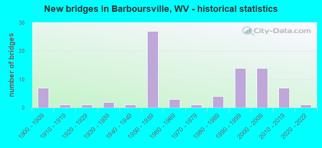
- New bridges - historical statistics
- 71900-1909
- 11910-1919
- 11920-1929
- 21930-1939
- 11940-1949
- 271950-1959
- 31960-1969
- 11970-1979
- 41980-1989
- 141990-1999
- 142000-2009
- 72010-2019
- 12020-2022

- Reconstructed bridges - Historical Statistics
- 81970-1979
- 21980-1989
- 01990-1999
- 12000-2009


- Bridge Condition - Deck
- 14.3%Good
- 42.9%Satisfactory
- 32.7%Fair
- 10.2%Poor

- Bridge Condition - Superstructure
- 28.6%Good
- 28.6%Satisfactory
- 32.7%Fair
- 10.2%Poor

- Bridge Condition - Substructure
- 14.3%Good
- 34.7%Satisfactory
- 28.6%Fair
- 22.4%Poor

- Bridge Condition - Channel
- 2.8%Very good
- 58.3%Good
- 27.8%Satisfactory
- 2.8%Fair
- 8.3%Poor

- Bridge Condition - Culverts
- 66.7%Satisfactory
- 33.3%Fair
Find on map >> Show street view
Structure Number: 6A267, Location: 0.38 MI E. OF C.R. 60/2 (Lat: 38.410800, Lng: -82.349989), Route carried "on" structure: County highway 6001, Year Built: 2003, Status: Open, Structure Length: 10.60m (34.78ft), Average Daily Traffic: 1,600 (year 2019), Truck Traffic: 8%, Average Future Daily Traffic: 1,936 (year 2039), Design Load: HL 93, Features Intersected: Interstate 64, Facility Carried by Structure: COUNTY ROUTE 60/1
Minimum Vertical Clearance: 30+ m (98+ ft), Kilometerpoint: 1.014, Lanes on structure: 2, Lanes under structure: 4, Owner: State Highway Agency, Approaching Roadway Width: 12.2m (40.0ft), Skew: 10 degrees, Material/Design: Prestressed concrete continuous, Design/Construction: Stringer/Multi-beam, Number Of Spans In Main Unit: 1, Number Of Approach Spans: 2, Length of Maximum Span: 39.0m (128.0ft), Curb or Sidewalk Widths: Left: 0.0m, Right: 1.5m (4.9ft), Curb-To-Curb Width: 9.1m (29.9ft), Out-to-Out Width: 11.3m (37.1ft)
Condition: Deck: Satisfactory, Superstructure: Fair, Substructure: Satisfactory, Operating Rating: 48.1 metric tons, Method Used To Determine Operating Rating: Load and Resistance Factor (LRFR), Inventory Rating: 26.3 metric tons, Method Used To Determine Inventory Rating: Load and Resistance Factor (LRFR), Structural Evaluation: Somewhat better than minimum adequacy, Deck Geometry: Somewhat better than minimum adequacy, Underclear: Somewhat better than minimum adequacy, Approach Roadway Alignment: Equal to present desirable criteria, Designated Inspection Frequency: Every 24 months, Inspection Date: June 2021, Deck Structure Type: Concrete Cast-file-Place, Wearing Surface/Protective System: Wearing Surface: Monolithic Concrete, Deck Protection: Epoxy Coated Reinforcing
Find on map >> Show street view
Structure Number: 6A271, Location: 0.01 MILES SOUTH OF CR 31 (Lat: 38.382050, Lng: -82.284831), Route carried "on" structure: County highway 3106, Year Built: 2005, Status: Open, Structure Length: 18.18m (59.65ft), Average Daily Traffic: 3,500 (year 2019), Truck Traffic: 7%, Average Future Daily Traffic: 3,773 (year 2039), Design Load: HS 25 or greater, Features Intersected: GUYANDOTTE RIVER, Facility Carried by Structure: COUNTY ROUTE 31/6
Minimum Vertical Clearance: 30+ m (98+ ft), Kilometerpoint: 0.772, Lanes on structure: 2, Owner: State Highway Agency, Approaching Roadway Width: 13.7m (44.9ft), Material/Design: Steel continuous, Design/Construction: Stringer/Multi-beam, Number Of Spans In Main Unit: 1, Number Of Approach Spans: 4, Length of Maximum Span: 53.3m (174.9ft), Curb or Sidewalk Widths: Left: 1.5m (4.9ft), Right: 0.0m, Curb-To-Curb Width: 12.2m (40.0ft), Out-to-Out Width: 13.6m (44.6ft)
Condition: Deck: Good, Superstructure: Good, Substructure: Satisfactory, Channel: Good, Operating Rating: 88.9 metric tons, Method Used To Determine Operating Rating: Load Factor (LF), Inventory Rating: 66.2 metric tons, Method Used To Determine Inventory Rating: Load Factor (LF), Structural Evaluation: Equal to present minimum criteria, Deck Geometry: Equal to present minimum criteria, Waterway Adequacy: Equal to present desirable criteria, Approach Roadway Alignment: Equal to present desirable criteria, Designated Inspection Frequency: Every 24 months, Underwater Inspection Frequency: Every 60 months, Inspection Date: May 2021, Underwater Inspection Date: July 2019, Deck Structure Type: Concrete Cast-file-Place, Wearing Surface/Protective System: Wearing Surface: Latex Concrete, Deck Protection: Epoxy Coated Reinforcing
Find on map >> Show street view
Structure Number: 6A272, Location: 0.22 MI. EAST OF WV 10 (Lat: 38.379450, Lng: -82.334539), Route carried "on" structure: County highway 1011, Year Built: 2005, Status: Open, Structure Length: 1.51m (4.95ft), Average Daily Traffic: 80 (year 2020), Truck Traffic: 8%, Average Future Daily Traffic: 97 (year 2040), Features Intersected: RIGHT FORK OF DAVIS CK, Facility Carried by Structure: COUNTY ROUTE 10/11
Minimum Vertical Clearance: 30+ m (98+ ft), Kilometerpoint: 0.354, Lanes on structure: 2, Owner: State Highway Agency, Approaching Roadway Width: 7.0m (23.0ft), Skew: 3 degrees, Material/Design: Prestressed concrete, Design/Construction: Box Beam or Girders - Multiple, Number Of Spans In Main Unit: 1, Length of Maximum Span: 14.6m (47.9ft), Curb-To-Curb Width: 7.3m (24.0ft), Out-to-Out Width: 7.3m (24.0ft)
Condition: Deck: Satisfactory, Superstructure: Satisfactory, Substructure: Satisfactory, Channel: Good, Operating Rating: 79.8 metric tons, Method Used To Determine Operating Rating: Load Factor (LF), Inventory Rating: 48.1 metric tons, Method Used To Determine Inventory Rating: Load Factor (LF), Structural Evaluation: Equal to present minimum criteria, Deck Geometry: Equal to present minimum criteria, Waterway Adequacy: Equal to present desirable criteria, Approach Roadway Alignment: Better than present minimum criteria, Designated Inspection Frequency: Every 24 months, Inspection Date: November 2021, Deck Structure Type: Other, Wearing Surface/Protective System: Wearing Surface: Bituminous, Deck Protection: Epoxy Coated Reinforcing
Find on map >> Show street view
Structure Number: 6A274, Location: 0.01 MILE N. OF CR 42/3 (Lat: 38.379400, Lng: -82.291111), Route carried "on" structure: County highway 4200, Year Built: 2006, Status: Open, Structure Length: 3.64m (11.94ft), Average Daily Traffic: 1,500 (year 2018), Truck Traffic: 7%, Average Future Daily Traffic: 1,905 (year 2038), Design Load: HL 93, Features Intersected: CSX RAILROAD, Facility Carried by Structure: COUNTY ROUTE 42
Minimum Vertical Clearance: 30+ m (98+ ft), Kilometerpoint: 10.316, Lanes on structure: 2, Owner: State Highway Agency, Approaching Roadway Width: 6.1m (20.0ft), Skew: 3 degrees, Material/Design: Steel, Design/Construction: Stringer/Multi-beam, Number Of Spans In Main Unit: 1, Length of Maximum Span: 35.6m (116.8ft), Curb-To-Curb Width: 10.4m (34.1ft), Out-to-Out Width: 11.1m (36.4ft)
Condition: Deck: Good, Superstructure: Good, Substructure: Good, Operating Rating: 70.7 metric tons, Method Used To Determine Operating Rating: Load and Resistance Factor (LRFR), Inventory Rating: 54.4 metric tons, Method Used To Determine Inventory Rating: Load and Resistance Factor (LRFR), Structural Evaluation: Better than present minimum criteria, Deck Geometry: Equal to present minimum criteria, Underclear: Equal to present desirable criteria, Approach Roadway Alignment: Equal to present minimum criteria, Designated Inspection Frequency: Every 24 months, Inspection Date: Febuary 2020, Deck Structure Type: Concrete Cast-file-Place, Wearing Surface/Protective System: Wearing Surface: Monolithic Concrete, Deck Protection: Epoxy Coated Reinforcing
Find on map >> Show street view
Structure Number: 6A275, Location: 0.02 MILES W. OF WV 193 (Lat: 38.418969, Lng: -82.290450), Route carried "on" structure: Interstate 6400, Year Built: 2000, Status: Open, Structure Length: 0.88m (2.89ft), Average Daily Traffic: 42,500 (year 2017), Truck Traffic: 17%, Average Future Daily Traffic: 65,450 (year 2037), Design Load: HS 20, Features Intersected: MERRICK CREEK, Facility Carried by Structure: I64 ACCESS RAMPS
Minimum Vertical Clearance: 30+ m (98+ ft), Kilometerpoint: 29.033, Lanes on structure: 2, Base Highway Network: Yes, Owner: State Highway Agency, Approaching Roadway Width: 7.3m (24.0ft), Material/Design: Concrete, Design/Construction: Culvert, Number Of Spans In Main Unit: 1, Number Of Approach Spans: 1, Length of Maximum Span: 2.7m (8.9ft)
Condition: Channel: Good, Culverts: Satisfactory, Operating Rating: 71.7 metric tons, Method Used To Determine Operating Rating: Field evaluation and documented engineering judgment, Inventory Rating: 32.7 metric tons, Method Used To Determine Inventory Rating: Field evaluation and documented engineering judgment, Structural Evaluation: Equal to present minimum criteria, Waterway Adequacy: Equal to present minimum criteria, Approach Roadway Alignment: Better than present minimum criteria, Designated Inspection Frequency: Every 24 months, Inspection Date: March 2020
Find on map >> Show street view
Structure Number: 6A276, Location: 0.03 MILES S OF CR 26/3 (Lat: 38.425531, Lng: -82.270750), Route carried "on" structure: County highway 2600, Year Built: 2006, Status: Open, Structure Length: 0.83m (2.72ft), Average Daily Traffic: 600 (year 2019), Truck Traffic: 7%, Average Future Daily Traffic: 720 (year 2039), Features Intersected: WILDCAT HOLLOW CREEK, Facility Carried by Structure: COUNTY ROUTE 26
Minimum Vertical Clearance: 30+ m (98+ ft), Kilometerpoint: 10.203, Lanes on structure: 1, Owner: State Highway Agency, Approaching Roadway Width: 4.9m (16.1ft), Material/Design: Aluminum, Iron, Design/Construction: Culvert, Number Of Spans In Main Unit: 1, Length of Maximum Span: 6.7m (22.0ft)
Condition: Channel: Good, Culverts: Fair, Operating Rating: 88.9 metric tons, Method Used To Determine Operating Rating: Field evaluation and documented engineering judgment, Inventory Rating: 40.8 metric tons, Method Used To Determine Inventory Rating: Field evaluation and documented engineering judgment, Structural Evaluation: Somewhat better than minimum adequacy, Waterway Adequacy: Equal to present desirable criteria, Approach Roadway Alignment: Better than present minimum criteria, Designated Inspection Frequency: Every 24 months, Inspection Date: January 2021
Find on map >> Show street view
Structure Number: 6A293, Location: 0.10 MILE WEST OF COUNTY (Lat: 38.416389, Lng: -82.251181), Route carried "on" structure: US 6000, Year Built: 2010, Status: Open, Structure Length: 4.92m (16.14ft), Average Daily Traffic: 19,500 (year 2018), Truck Traffic: 5%, Average Future Daily Traffic: 25,350 (year 2038), Design Load: HL 93, Features Intersected: CSX Railway, Facility Carried by Structure: US 60
Minimum Vertical Clearance: 30+ m (98+ ft), Kilometerpoint: 24.140, Lanes on structure: 3, Owner: State Highway Agency, Approaching Roadway Width: 11.0m (36.1ft), Skew: 3 degrees, Material/Design: Steel, Design/Construction: Stringer/Multi-beam, Number Of Spans In Main Unit: 1, Length of Maximum Span: 47.9m (157.2ft), Curb or Sidewalk Widths: Left: 0.4m (1.3ft), Right: 0.4m (1.3ft), Curb-To-Curb Width: 15.6m (51.2ft), Out-to-Out Width: 16.4m (53.8ft)
Condition: Deck: Satisfactory, Superstructure: Good, Substructure: Satisfactory, Operating Rating: 40.8 metric tons, Method Used To Determine Operating Rating: Load and Resistance Factor (LRFR), Inventory Rating: 31.7 metric tons, Method Used To Determine Inventory Rating: Load and Resistance Factor (LRFR), Structural Evaluation: Equal to present minimum criteria, Deck Geometry: Equal to present minimum criteria, Underclear: Equal to present minimum criteria, Approach Roadway Alignment: Equal to present desirable criteria, Designated Inspection Frequency: Every 24 months, Inspection Date: March 2020, Deck Structure Type: Concrete Cast-file-Place
Find on map >> Show street view
Structure Number: 6A295, Location: 0.18 MILES NORTH OF CR 19 (Lat: 38.440361, Lng: -82.289739), Route carried "on" structure: County highway 2400, Year Built: 2011, Status: Open, Structure Length: 1.30m (4.27ft), Average Daily Traffic: 120 (year 2019), Truck Traffic: 7%, Average Future Daily Traffic: 152 (year 2039), Design Load: HL 93, Features Intersected: MERRICK CREEK, Facility Carried by Structure: COUNTY ROUTE 24
Minimum Vertical Clearance: 30+ m (98+ ft), Kilometerpoint: 0.290, Lanes on structure: 2, Owner: State Highway Agency, Approaching Roadway Width: 6.4m (21.0ft), Skew: 3 degrees, Material/Design: Steel, Design/Construction: Stringer/Multi-beam, Number Of Spans In Main Unit: 1, Length of Maximum Span: 11.6m (38.1ft), Curb-To-Curb Width: 7.4m (24.3ft), Out-to-Out Width: 7.5m (24.6ft)
Condition: Deck: Satisfactory, Superstructure: Good, Substructure: Good, Channel: Good, Operating Rating: 44.4 metric tons, Method Used To Determine Operating Rating: Load and Resistance Factor (LRFR), Inventory Rating: 34.5 metric tons, Method Used To Determine Inventory Rating: Load and Resistance Factor (LRFR), Structural Evaluation: Better than present minimum criteria, Deck Geometry: Somewhat better than minimum adequacy, Waterway Adequacy: Better than present minimum criteria, Approach Roadway Alignment: Equal to present minimum criteria, Designated Inspection Frequency: Every 24 months, Inspection Date: January 2021, Deck Structure Type: Corrugated Steel, Wearing Surface/Protective System: Wearing Surface: Other, Membrane: Other
Find on map >> Show street view
Structure Number: 6A297, Location: 0.01 mile north of US 60 (Lat: 38.410300, Lng: -82.270561), Route carried "on" structure: County highway 16004, Year Built: 2011, Status: Open, Structure Length: 8.58m (28.15ft), Average Daily Traffic: 150 (year 2020), Truck Traffic: 8%, Average Future Daily Traffic: 182 (year 2040), Design Load: HL 93, Features Intersected: Mud River, Facility Carried by Structure: County Route 160/4
Minimum Vertical Clearance: 30+ m (98+ ft), Kilometerpoint: 0.016, Lanes on structure: 2, Owner: State Highway Agency, Approaching Roadway Width: 7.3m (24.0ft), Skew: 1 degrees, Material/Design: Steel continuous, Design/Construction: Stringer/Multi-beam, Number Of Spans In Main Unit: 1, Number Of Approach Spans: 2, Length of Maximum Span: 44.2m (145.0ft), Curb-To-Curb Width: 7.3m (24.0ft), Out-to-Out Width: 8.1m (26.6ft)
Condition: Deck: Satisfactory, Superstructure: Good, Substructure: Satisfactory, Channel: Good, Operating Rating: 39.9 metric tons, Method Used To Determine Operating Rating: Load and Resistance Factor (LRFR), Inventory Rating: 30.8 metric tons, Method Used To Determine Inventory Rating: Load and Resistance Factor (LRFR), Structural Evaluation: Equal to present minimum criteria, Deck Geometry: Somewhat better than minimum adequacy, Waterway Adequacy: Equal to present desirable criteria, Approach Roadway Alignment: Equal to present minimum criteria, Designated Inspection Frequency: Every 24 months, Inspection Date: October 2021, Deck Structure Type: Concrete Cast-file-Place, Wearing Surface/Protective System: Wearing Surface: Monolithic Concrete, Deck Protection: Epoxy Coated Reinforcing
Find on map >> Show street view
Structure Number: 6A302, Location: 0.93 MI N OF CR 1 (Lat: 38.454169, Lng: -82.222761), Route carried "on" structure: County highway 111, Year Built: 2012, Status: Open, Structure Length: 2.26m (7.41ft), Average Daily Traffic: 70 (year 2014), Truck Traffic: 7%, Average Future Daily Traffic: 89 (year 2038), Design Load: HL 93, Features Intersected: BIG CABELL CREEK, Facility Carried by Structure: CR 1/11
Minimum Vertical Clearance: 30+ m (98+ ft), Kilometerpoint: 7.934, Lanes on structure: 2, Owner: State Highway Agency, Approaching Roadway Width: 4.0m (13.1ft), Skew: 3 degrees, Material/Design: Prestressed concrete, Design/Construction: Box Beam or Girders - Multiple, Number Of Spans In Main Unit: 1, Length of Maximum Span: 21.3m (69.9ft), Curb-To-Curb Width: 5.5m (18.0ft), Out-to-Out Width: 5.5m (18.0ft)
Condition: Deck: Good, Superstructure: Good, Substructure: Good, Channel: Good, Operating Rating: 40.8 metric tons, Method Used To Determine Operating Rating: Load and Resistance Factor (LRFR), Inventory Rating: 32.7 metric tons, Method Used To Determine Inventory Rating: Load and Resistance Factor (LRFR), Structural Evaluation: Better than present minimum criteria, Waterway Adequacy: Equal to present desirable criteria, Approach Roadway Alignment: Equal to present desirable criteria, Designated Inspection Frequency: Every 48 months, Inspection Date: December 2020, Deck Structure Type: Other, Wearing Surface/Protective System: Wearing Surface: Monolithic Concrete, Deck Protection: Epoxy Coated Reinforcing
Find on map >> Show street view
Structure Number: 6A309, Location: 0.01 MI North of U.S. 60 (Lat: 38.416450, Lng: -82.290289), Route carried "on" structure: State highway 19300, Year Built: 2000, Status: Open, Structure Length: 7.03m (23.06ft), Average Daily Traffic: 13,500 (year 2019), Truck Traffic: 4%, Average Future Daily Traffic: 16,875 (year 2039), Design Load: HS 25 or greater, Features Intersected: MUD RIVER, Facility Carried by Structure: WV 193 NB
Minimum Vertical Clearance: 30+ m (98+ ft), Kilometerpoint: 0.016, Lanes on structure: 3, Owner: State Highway Agency, Approaching Roadway Width: 10.7m (35.1ft), Skew: 2 degrees, Material/Design: Prestressed concrete continuous, Design/Construction: Stringer/Multi-beam, Number Of Spans In Main Unit: 1, Number Of Approach Spans: 2, Length of Maximum Span: 28.7m (94.2ft), Curb or Sidewalk Widths: Left: 2.2m (7.2ft), Right: 0.0m, Curb-To-Curb Width: 10.7m (35.1ft), Out-to-Out Width: 11.2m (36.7ft)
Condition: Deck: Satisfactory, Superstructure: Good, Substructure: Good, Channel: Satisfactory, Operating Rating: 59.9 metric tons, Method Used To Determine Operating Rating: Load Factor (LF), Inventory Rating: 35.4 metric tons, Method Used To Determine Inventory Rating: Load Factor (LF), Structural Evaluation: Better than present minimum criteria, Deck Geometry: High priority of replacement, Waterway Adequacy: Equal to present minimum criteria, Approach Roadway Alignment: Better than present minimum criteria, Designated Inspection Frequency: Every 24 months, Inspection Date: December 2020, Deck Structure Type: Concrete Cast-file-Place, Wearing Surface/Protective System: Wearing Surface: Monolithic Concrete
Find on map >> Show street view
Structure Number: 6A313, Location: 1.2 mile south of U.S. 60 (Lat: 38.410489, Lng: -82.209961), Route carried "on" structure: County highway 2900, Year Built: 2018, Status: Open, Structure Length: 1.59m (5.22ft), Average Daily Traffic: 600 (year 2019), Truck Traffic: 7%, Average Future Daily Traffic: 765 (year 2040), Design Load: HL 93, Features Intersected: Fudges Creek, Facility Carried by Structure: County Route 29
Minimum Vertical Clearance: 30+ m (98+ ft), Kilometerpoint: 13.744, Lanes on structure: 2, Owner: State Highway Agency, Approaching Roadway Width: 8.2m (26.9ft), Skew: 1 degrees, Material/Design: Prestressed concrete, Design/Construction: Box Beam or Girders - Multiple, Number Of Spans In Main Unit: 1, Length of Maximum Span: 14.8m (48.6ft), Curb-To-Curb Width: 9.3m (30.5ft), Out-to-Out Width: 9.4m (30.8ft)
Condition: Deck: Good, Superstructure: Good, Substructure: Good, Channel: Good, Operating Rating: 67.1 metric tons, Method Used To Determine Operating Rating: Load and Resistance Factor (LRFR), Inventory Rating: 51.7 metric tons, Method Used To Determine Inventory Rating: Load and Resistance Factor (LRFR), Structural Evaluation: Better than present minimum criteria, Deck Geometry: Equal to present minimum criteria, Waterway Adequacy: Equal to present minimum criteria, Approach Roadway Alignment: Equal to present minimum criteria, Designated Inspection Frequency: Every 24 months, Inspection Date: April 2020, Deck Structure Type: Concrete Cast-file-Place, Wearing Surface/Protective System: Wearing Surface: Monolithic Concrete, Deck Protection: Epoxy Coated Reinforcing
Find on map >> Show street view
Structure Number: 6A318, Location: 0.11 mile north of CO 31 (Lat: 38.377389, Lng: -82.249581), Route carried "on" structure: County highway 3000, Year Built: 2019, Status: Open, Structure Length: 1.58m (5.18ft), Average Daily Traffic: 2,600 (year 2020), Truck Traffic: 8%, Average Future Daily Traffic: 3,146 (year 2040), Design Load: HL 93, Features Intersected: TOMS CREEK, Facility Carried by Structure: CO 30
Minimum Vertical Clearance: 30+ m (98+ ft), Kilometerpoint: 0.177, Lanes on structure: 2, Owner: State Highway Agency, Approaching Roadway Width: 8.5m (27.9ft), Skew: 3 degrees, Material/Design: Prestressed concrete, Design/Construction: Box Beam or Girders - Multiple, Number Of Spans In Main Unit: 1, Length of Maximum Span: 13.4m (44.0ft), Curb-To-Curb Width: 8.2m (26.9ft), Out-to-Out Width: 8.3m (27.2ft)
Condition: Deck: Good, Superstructure: Good, Substructure: Good, Channel: Good, Operating Rating: 63.5 metric tons, Method Used To Determine Operating Rating: Load and Resistance Factor (LRFR), Inventory Rating: 49.9 metric tons, Method Used To Determine Inventory Rating: Load and Resistance Factor (LRFR), Structural Evaluation: Better than present minimum criteria, Deck Geometry: High priority of corrective action, Waterway Adequacy: Somewhat better than minimum adequacy, Approach Roadway Alignment: Equal to present minimum criteria, Designated Inspection Frequency: Every 24 months, Inspection Date: November 2021, Deck Structure Type: Concrete Cast-file-Place
Find on map >> Show street view
Structure Number: 6A328, Location: 0.01 MILE EAST OF CO 30 (Lat: 38.375911, Lng: -82.250600), Route carried "on" structure: County highway 3100, Year Built: 2020, Status: Open, Structure Length: 1.28m (4.20ft), Average Daily Traffic: 2,900 (year 2017), Truck Traffic: 7%, Average Future Daily Traffic: 3,683 (year 2037), Design Load: HL 93, Features Intersected: UPPER TOMS CREEK, Facility Carried by Structure: CO 31
Minimum Vertical Clearance: 30+ m (98+ ft), Kilometerpoint: 7.596, Lanes on structure: 2, Owner: State Highway Agency, Approaching Roadway Width: 8.8m (28.9ft), Material/Design: Prestressed concrete, Design/Construction: Box Beam or Girders - Multiple, Number Of Spans In Main Unit: 1, Length of Maximum Span: 11.6m (38.1ft), Curb-To-Curb Width: 9.1m (29.9ft), Out-to-Out Width: 9.2m (30.2ft)
Condition: Deck: Good, Superstructure: Good, Substructure: Good, Channel: Very good, Operating Rating: 89.8 metric tons, Method Used To Determine Operating Rating: Load and Resistance Factor (LRFR), Inventory Rating: 89.8 metric tons, Method Used To Determine Inventory Rating: Load and Resistance Factor (LRFR), Structural Evaluation: Better than present minimum criteria, Deck Geometry: Meets minimum limits, Waterway Adequacy: Somewhat better than minimum adequacy, Approach Roadway Alignment: Equal to present minimum criteria, Designated Inspection Frequency: Every 24 months, Inspection Date: August 2020, Deck Structure Type: Concrete Cast-file-Place, Wearing Surface/Protective System: Wearing Surface: Bituminous, Membrane: Epoxy, Deck Protection: Epoxy Coated Reinforcing
Find on map >> Show street view
Structure Number: 6A915, Location: 0.20 mile N of CR 42/16 (Lat: 38.393219, Lng: -82.317611), Route carried "on" structure: City street N0800, Year Built: 2011, Status: Open, Structure Length: 4.69m (15.39ft), Average Daily Traffic: 100 (year 2019), Truck Traffic: 7%, Average Future Daily Traffic: 127 (year 2039), Design Load: HS 20+Mod, Features Intersected: CSX Railroad, Facility Carried by Structure: DEER PARK ROAD
Minimum Vertical Clearance: 30+ m (98+ ft), Kilometerpoint: 0.016, Lanes on structure: 2, Owner: City or Municipal Highway Agency, Approaching Roadway Width: 6.7m (22.0ft), Material/Design: Steel, Design/Construction: Truss - Thru, Number Of Spans In Main Unit: 1, Length of Maximum Span: 45.7m (149.9ft), Curb or Sidewalk Widths: Left: 1.6m (5.2ft), Right: 0.0m, Curb-To-Curb Width: 6.7m (22.0ft), Out-to-Out Width: 6.7m (22.0ft)
Condition: Deck: Satisfactory, Superstructure: Satisfactory, Substructure: Fair, Operating Rating: 47.2 metric tons, Method Used To Determine Operating Rating: Load and Resistance Factor (LRFR), Inventory Rating: 36.3 metric tons, Method Used To Determine Inventory Rating: Load and Resistance Factor (LRFR), Structural Evaluation: Somewhat better than minimum adequacy, Deck Geometry: Somewhat better than minimum adequacy, Underclear: Superior to present desirable criteria, Approach Roadway Alignment: Equal to present minimum criteria, Designated Inspection Frequency: Every 24 months, Critical Feature Inspection Frequency: Every 24 months, Inspection Date: April 2021, Critical Feature Inspection Date: April 2021, Deck Structure Type: Corrugated Steel, Wearing Surface/Protective System: Wearing Surface: Bituminous
Find on map >> Show street view
Structure Number: 6A001, Location: 0.11 MI NORTH OF CR 60/35 (Lat: 38.427339, Lng: -82.223731), Route carried "under" structure: County highway 100, Year Built: 1909, Structure Length: 0. m, Average Daily Traffic: 3,300 (year 2018), Truck Traffic: 4%, Features Intersected: COUNTY ROUTE 1, Facility Carried by Structure: CSX RAILROAD
Minimum Vertical Clearance: 4.78m (15.68ft), Kilometerpoint: 1.110, Lanes under structure: 2, Length of Maximum Span: 7.2m (23.6ft)
Find on map >> Show street view
Structure Number: 6A042, Location: 0.11 MI WEST OF CR 17/2 (Lat: 38.425961, Lng: -82.237011), Route carried "under" structure: Interstate 6400, Year Built: 1961, Structure Length: 0. m, Average Daily Traffic: 13,750 (year 0008), Truck Traffic: 21%, Features Intersected: INTERSTATE 64, Facility Carried by Structure: CR 17
Minimum Vertical Clearance: 5.11m (16.77ft), Kilometerpoint: 34.022, Lanes on structure: 2, Lanes under structure: 2, Length of Maximum Span: 18.9m (62.0ft)
Find on map >> Show street view
Structure Number: 6A044, Location: 0.07 MI WEST OF US 60 (Lat: 38.419261, Lng: -82.240889), Route carried "under" structure: County highway 1725, Year Built: 1907, Structure Length: 0. m, Average Daily Traffic: 80 (year 2020), Truck Traffic: 8%, Features Intersected: CSX RAILROAD, Facility Carried by Structure: CSX RAILROAD
Minimum Vertical Clearance: 3.45m (11.32ft), Kilometerpoint: 0.113, Lanes under structure: 1, Length of Maximum Span: 4.6m (15.1ft)
Find on map >> Show street view
Structure Number: 6A047, Location: 0.25 MI SOUTH OF CR 19 (Lat: 38.416669, Lng: -82.294431), Route carried "under" structure: County highway 2600, Year Built: 1904, Structure Length: 0. m, Average Daily Traffic: 1,400 (year 2019), Truck Traffic: 8%, Features Intersected: COUNTY ROUTE 26, Facility Carried by Structure: CSX RAILROAD
Minimum Vertical Clearance: 3.76m (12.34ft), Kilometerpoint: 7.548, Lanes under structure: 2, Length of Maximum Span: 34.3m (112.5ft)
Find on map >> Show street view
Structure Number: 6A066, Location: 1.69 MI NORTH OF CR 26/1 (Lat: 38.427961, Lng: -82.318089), Route carried "under" structure: County highway 2600, Year Built: 1905, Structure Length: 0. m, Average Daily Traffic: 1,700 (year 2019), Truck Traffic: 8%, Features Intersected: C. R. 26, Facility Carried by Structure: CSX RAILROAD
Minimum Vertical Clearance: 4.17m (13.68ft), Kilometerpoint: 4.715, Lanes under structure: 1, Length of Maximum Span: 6.9m (22.6ft)
Find on map >> Show street view
Structure Number: 6A121, Location: 0.02 MI EAST OF CR 60/9 (Lat: 38.416050, Lng: -82.294100), Route carried "under" structure: US 6000, Year Built: 1904, Structure Length: 0. m, Average Daily Traffic: 14,862 (year 2019), Truck Traffic: 7%, Features Intersected: US 60, Facility Carried by Structure: CSX RAILROAD
Minimum Vertical Clearance: 4.62m (15.16ft), Kilometerpoint: 19.795, Lanes under structure: 2, Length of Maximum Span: 33.9m (111.2ft)
Find on map >> Show street view
Structure Number: 6A127, Location: 0.01 MI WEST OF US 60 (Lat: 38.410750, Lng: -82.281561), Route carried "under" structure: County highway 6005, Year Built: 1906, Structure Length: 0. m, Average Daily Traffic: 8,300 (year 2016), Truck Traffic: 4%, Features Intersected: COUNTY ROUTE 60/5, Facility Carried by Structure: CSX RAILROAD
Minimum Vertical Clearance: 3.94m (12.93ft), Kilometerpoint: 4.796, Lanes under structure: 2, Length of Maximum Span: 10.1m (33.1ft)
Find on map >> Show street view
Structure Number: 6A14, Location: 0.20 MI EAST OF CR 60/1 (Lat: 38.413450, Lng: -82.347939), Route carried "under" structure: US 6000, Year Built: 1958, Structure Length: 0. m, Average Daily Traffic: 39,100 (year 0013), Truck Traffic: 4%, Features Intersected: US ROUTE 60, Facility Carried by Structure: I64 EB
Minimum Vertical Clearance: 5.00m (16.40ft), Kilometerpoint: 14.935, Lanes on structure: 3, Lanes under structure: 4, Length of Maximum Span: 18.0m (59.1ft)
Find on map >> Show street view
Structure Number: 6A141, Location: 1.78 MI WEST OF CR 60/89 (Lat: 38.422536, Lng: -82.300203), Route carried "under" structure: County highway 6052, Year Built: 1959, Structure Length: 0. m, Average Daily Traffic: 37 (year 0017), Features Intersected: Guyandotte R, CR60/52&26, Facility Carried by Structure: I 64 EB
Minimum Vertical Clearance: 4.85m (15.91ft), Kilometerpoint: 0.467, Lanes on structure: 2, Lanes under structure: 2, Length of Maximum Span: 42.1m (138.1ft)
Find on map >> Show street view
Structure Number: 6A141, Location: 1.78 MI WEST OF CR 60/89 (Lat: 38.421744, Lng: -82.297650), Route carried "under" structure: County highway 2600, Year Built: 1959, Structure Length: 0. m, Average Daily Traffic: 619 (year 0016), Truck Traffic: 4%, Features Intersected: Guyandotte R, CR60/52&26, Facility Carried by Structure: I 64 EB
Minimum Vertical Clearance: 8.23m (27.00ft), Kilometerpoint: 6.888, Lanes on structure: 2, Lanes under structure: 2, Length of Maximum Span: 42.1m (138.1ft)
Find on map >> Show street view
Structure Number: 6A142, Location: 1.44 MI WEST OF CR 60/89 (Lat: 38.419281, Lng: -82.290039), Route carried "under" structure: State highway 19300, Year Built: 1959, Structure Length: 0. m, Average Daily Traffic: 9,700 (year 0007), Truck Traffic: 4%, Features Intersected: WV ROUTE 193, Facility Carried by Structure: I 64 EB
Minimum Vertical Clearance: 5.13m (16.83ft), Kilometerpoint: 0.402, Lanes on structure: 2, Lanes under structure: 2, Length of Maximum Span: 32.6m (107.0ft)
Find on map >> Show street view
Structure Number: 6A143, Location: 0.99 MI WEST OF CR 60/89 (Lat: 38.416989, Lng: -82.282781), Route carried "under" structure: County highway 2600, Year Built: 1958, Structure Length: 0. m, Average Daily Traffic: 500 (year 0007), Truck Traffic: 4%, Features Intersected: COUNTY ROUTE 26, Facility Carried by Structure: I 64 EB
Minimum Vertical Clearance: 4.62m (15.16ft), Kilometerpoint: 8.674, Lanes on structure: 2, Lanes under structure: 2, Length of Maximum Span: 13.1m (43.0ft)
Find on map >> Show street view
Structure Number: 6A144, Location: 0.21 MI WEST OF CR 60/89 (Lat: 38.415761, Lng: -82.268331), Route carried "under" structure: County highway 2602, Year Built: 1959, Structure Length: 0. m, Average Daily Traffic: 100 (year 0006), Features Intersected: MUD RIVER AND CO RT 26/2, Facility Carried by Structure: I 64 EB
Minimum Vertical Clearance: 5.00m (16.40ft), Kilometerpoint: 1.529, Lanes on structure: 2, Lanes under structure: 2, Length of Maximum Span: 38.1m (125.0ft)
Find on map >> Show street view
Structure Number: 6A145, Location: 1.69 MILES EAST OF CR 19 (Lat: 38.418014, Lng: -82.261064), Route carried "under" structure: County highway 6089, Year Built: 1958, Structure Length: 0. m, Average Daily Traffic: 15,000 (year 0007), Truck Traffic: 4%, Features Intersected: County Route 60/89, Facility Carried by Structure: I 64
Minimum Vertical Clearance: 4.52m (14.83ft), Kilometerpoint: 0.241, Lanes on structure: 2, Lanes under structure: 4, Length of Maximum Span: 16.8m (55.1ft)
Find on map >> Show street view
Structure Number: 6A174, Location: 0.24 MI EAST OF CR 60/5 (Lat: 38.406519, Lng: -82.294919), Route carried "under" structure: County highway 3100, Year Built: 1928, Structure Length: 0. m, Average Daily Traffic: 4,800 (year 2018), Truck Traffic: 4%, Features Intersected: CSX RAILROAD, Facility Carried by Structure: CSX RAILROAD
Minimum Vertical Clearance: 3.63m (11.91ft), Kilometerpoint: 0.386, Lanes under structure: 2, Material/Design: Steel, Design/Construction: Stringer/Multi-beam, Length of Maximum Span: 9.8m (32.2ft)
Find on map >> Show street view
Structure Number: 6A187, Location: 0.20 MI EAST OF CR 60/1 (Lat: 38.413431, Lng: -82.348250), Route carried "under" structure: US 6000, Year Built: 1958, Structure Length: 0. m, Average Daily Traffic: 39,100 (year 0013), Truck Traffic: 4%, Features Intersected: US ROUTE 60, Facility Carried by Structure: I64 WB
Minimum Vertical Clearance: 5.00m (16.40ft), Kilometerpoint: 14.935, Lanes on structure: 3, Lanes under structure: 4, Length of Maximum Span: 18.0m (59.1ft)
Find on map >> Show street view
Structure Number: 6A188, Location: 1.78 MI WEST OF CR 60/89 (Lat: 38.422522, Lng: -82.300178), Route carried "under" structure: County highway 6052, Year Built: 1959, Structure Length: 0. m, Average Daily Traffic: 37 (year 0017), Features Intersected: Guyandotte R, CR60/52&26, Facility Carried by Structure: I 64 WB
Minimum Vertical Clearance: 4.85m (15.91ft), Kilometerpoint: 0.467, Lanes on structure: 2, Lanes under structure: 2, Length of Maximum Span: 42.1m (138.1ft)
Find on map >> Show street view
Structure Number: 6A188, Location: 1.78 MI WEST OF CR 60/89 (Lat: 38.421744, Lng: -82.297650), Route carried "under" structure: County highway 2600, Year Built: 1959, Structure Length: 0. m, Average Daily Traffic: 1,479 (year 0017), Truck Traffic: 4%, Features Intersected: Guyandotte R, CR60/52&26, Facility Carried by Structure: I 64 WB
Minimum Vertical Clearance: 8.18m (26.84ft), Kilometerpoint: 6.888, Lanes on structure: 2, Lanes under structure: 2, Length of Maximum Span: 42.1m (138.1ft)
Find on map >> Show street view
Structure Number: 6A189, Location: 1.44 MI WEST OF CR 60/89 (Lat: 38.419439, Lng: -82.290000), Route carried "under" structure: State highway 19300, Year Built: 1959, Structure Length: 0. m, Average Daily Traffic: 9,700 (year 0007), Truck Traffic: 4%, Features Intersected: WV ROUTE 193, Facility Carried by Structure: I 64 WB
Minimum Vertical Clearance: 5.13m (16.83ft), Kilometerpoint: 0.402, Lanes on structure: 2, Lanes under structure: 2, Length of Maximum Span: 32.6m (107.0ft)
Find on map >> Show street view
Structure Number: 6A19, Location: 0.21 MI WEST OF CR 60/89 (Lat: 38.415761, Lng: -82.268411), Route carried "under" structure: County highway 2602, Year Built: 1959, Structure Length: 0. m, Average Daily Traffic: 100 (year 0006), Features Intersected: MUD RIVER AND CO RT 26/2, Facility Carried by Structure: I 64 WB
Minimum Vertical Clearance: 5.00m (16.40ft), Kilometerpoint: 1.529, Lanes on structure: 2, Lanes under structure: 2, Length of Maximum Span: 38.1m (125.0ft)
Find on map >> Show street view
Structure Number: 6A191, Location: 0.99 MI WEST OF CR 60/8 (Lat: 38.417161, Lng: -82.282700), Route carried "under" structure: County highway 2600, Year Built: 1958, Structure Length: 0. m, Average Daily Traffic: 500 (year 0007), Truck Traffic: 4%, Features Intersected: INTERSTATE 64, Facility Carried by Structure: I 64 WB
Minimum Vertical Clearance: 4.62m (15.16ft), Kilometerpoint: 8.674, Lanes on structure: 2, Lanes under structure: 2, Length of Maximum Span: 13.1m (43.0ft)
Find on map >> Show street view
Structure Number: 6A192, Location: 1.69 MI EAST OF CR 19 (Lat: 38.418014, Lng: -82.261064), Route carried "under" structure: County highway 6089, Year Built: 1958, Structure Length: 0. m, Average Daily Traffic: 15,000 (year 0007), Truck Traffic: 4%, Features Intersected: County Route 60/89, Facility Carried by Structure: I 64
Minimum Vertical Clearance: 4.52m (14.83ft), Kilometerpoint: 0.241, Lanes on structure: 2, Lanes under structure: 4, Length of Maximum Span: 16.8m (55.1ft)
Find on map >> Show street view
Structure Number: 6A211, Location: 0.05 MI EAST OF US 60 (Lat: 38.410639, Lng: -82.263850), Route carried "under" structure: County highway 6008, Year Built: 1907, Structure Length: 0. m, Average Daily Traffic: 50 (year 2018), Features Intersected: COUNTY ROUTE 60/8, Facility Carried by Structure: CSX RAILROAD
Minimum Vertical Clearance: 2.90m (9.51ft), Kilometerpoint: 0.080, Lanes under structure: 1, Length of Maximum Span: 4.9m (16.1ft)
Find on map >> Show street view
Structure Number: 6A217, Location: 0.04 MI EAST OF CR 42 (Lat: 38.361550, Lng: -82.277639), Route carried "under" structure: County highway 4205, Year Built: 1918, Structure Length: 0. m, Average Daily Traffic: 50 (year 2018), Features Intersected: COUNTY ROUTE 42/5, Facility Carried by Structure: CSX RAILROAD
Minimum Vertical Clearance: 3.91m (12.83ft), Kilometerpoint: 0.064, Lanes under structure: 2, Length of Maximum Span: 11.6m (38.1ft)
Find on map >> Show street view
Structure Number: 6A227, Location: 1.19 MI WEST OF CR 31 (Lat: 38.406169, Lng: -82.314489), Route carried "under" structure: County highway 3101, Year Built: 1995, Structure Length: 0. m, Average Daily Traffic: 100 (year 2018), Features Intersected: COUNTY ROUTE 31/1, Facility Carried by Structure: CSX RAILROAD
Minimum Vertical Clearance: 3.58m (11.75ft), Kilometerpoint: 1.915, Lanes under structure: 1, Material/Design: Steel, Design/Construction: Girder and Floorbeam System, Length of Maximum Span: 5.0m (16.4ft)
Find on map >> Show street view
Structure Number: 6A242, Location: 1.75 MI. E. OF CR 60/89 (Lat: 38.429539, Lng: -82.225900), Route carried "under" structure: County highway 100, Year Built: 1998, Structure Length: 0. m, Average Daily Traffic: 350 (year 0007), Truck Traffic: 4%, Features Intersected: MUD RIVER & CO 1, Facility Carried by Structure: I64 (EB)
Minimum Vertical Clearance: 13.03m (42.75ft), Kilometerpoint: 1.416, Lanes on structure: 2, Lanes under structure: 2, Length of Maximum Span: 36.4m (119.4ft)
Find on map >> Show street view
Structure Number: 6A243, Location: 1.75 MI. EAST OF CR 60/89 (Lat: 38.429689, Lng: -82.225989), Route carried "under" structure: County highway 100, Year Built: 1998, Structure Length: 0. m, Average Daily Traffic: 350 (year 0007), Truck Traffic: 4%, Features Intersected: MUD RIVER & C.R.1, Facility Carried by Structure: I64 (WB)
Minimum Vertical Clearance: 13.03m (42.75ft), Kilometerpoint: 1.416, Lanes on structure: 2, Lanes under structure: 2, Length of Maximum Span: 36.4m (119.4ft)
Find on map >> Show street view
Structure Number: 6A255, Location: 0.10 MILE NORTH OF US 60 (Lat: 38.416950, Lng: -82.264431), Route carried "under" structure: Interstate 6400, Year Built: 1999, Structure Length: 0. m, Average Daily Traffic: 44,000 (year 0012), Truck Traffic: 21%, Features Intersected: I64 / Mall Access Road, Facility Carried by Structure: CR 160/18
Minimum Vertical Clearance: 6.22m (20.41ft), Kilometerpoint: 31.736, Lanes on structure: 4, Lanes under structure: 6, Length of Maximum Span: 42.4m (139.1ft)
Find on map >> Show street view
Structure Number: 6A255, Location: 0.10 MILE NORTH OF US 60 (Lat: 38.417411, Lng: -82.264850), Route carried "under" structure: ServiceOther road , Year Built: 1999, Structure Length: 0. m, Features Intersected: I64 / Mall Access Road, Facility Carried by Structure: CR 160/18
Minimum Vertical Clearance: 4.62m (15.16ft), Lanes on structure: 4, Length of Maximum Span: 42.4m (139.1ft)
Find on map >> Show street view
Structure Number: 6A26, Location: 0.01 MILE NORTH OF US 60 (Lat: 38.418900, Lng: -82.237789), Route carried "under" structure: County highway 1710, Year Built: 2001, Structure Length: 0. m, Average Daily Traffic: 100 (year 0007), Features Intersected: MUD RIVER, Facility Carried by Structure: CR 17
Minimum Vertical Clearance: 7.52m (24.67ft), Kilometerpoint: 0.080, Lanes on structure: 2, Lanes under structure: 1, Length of Maximum Span: 56.7m (186.0ft)
Find on map >> Show street view
Structure Number: 6A267, Location: 0.38 MI E. OF C.R. 60/2 (Lat: 38.410839, Lng: -82.349939), Route carried "under" structure: Ramp Interstate 6400, Year Built: 2003, Structure Length: 0. m, Average Daily Traffic: 41,000 (year 0006), Truck Traffic: 21%, Features Intersected: Interstate 64, Facility Carried by Structure: COUNTY ROUTE 60/1
Minimum Vertical Clearance: 30+ m (98+ ft), Kilometerpoint: 23.062, Lanes on structure: 2, Lanes under structure: 4, Length of Maximum Span: 39.0m (128.0ft)