Bridge Statistics for Battle Creek, Michigan (MI)
Condition, Traffic, Stress, Structural Evaluation, Project Costs
- National Bridge Inventory (NBI) Statistics
- 70Number of bridges
- 817ft / 249mTotal length
- $870,000Total costs
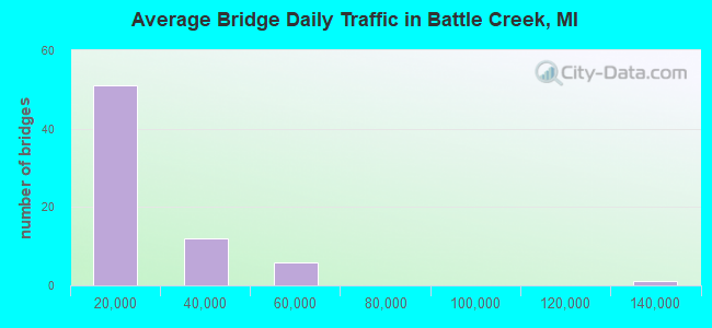
- 1,046,313Total average daily traffic
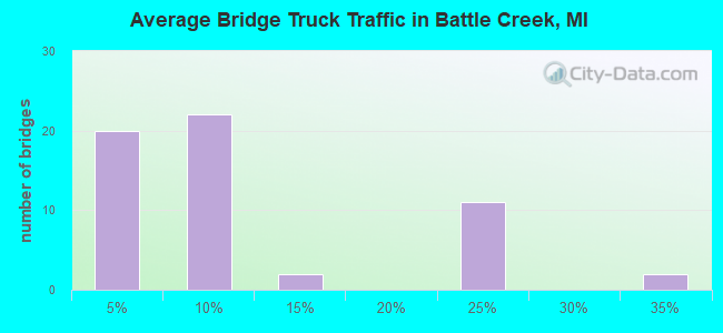
- 137,339Total average daily truck traffic
- National Bridge Inventory (NBI) Registered Bridges for Battle Creek
- No street view available for this location
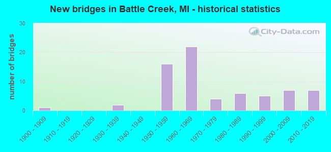
- New bridges - historical statistics
- 11900-1909
- 21930-1939
- 161950-1959
- 221960-1969
- 41970-1979
- 61980-1989
- 51990-1999
- 72000-2009
- 72010-2019
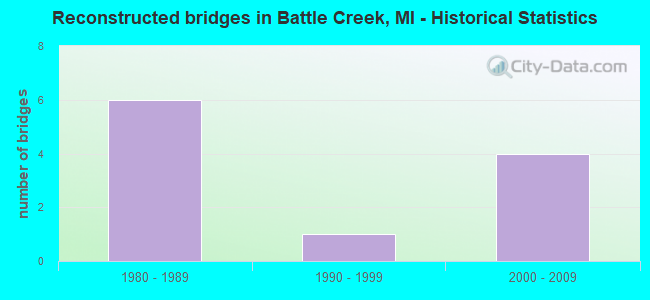
- Reconstructed bridges - Historical Statistics
- 61980-1989
- 11990-1999
- 42000-2009
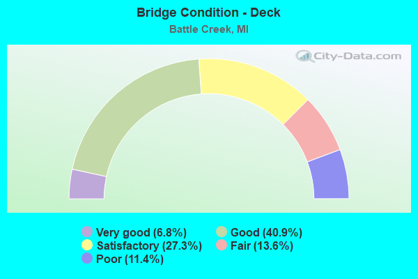
- Bridge Condition - Deck
- 6.8%Very good
- 40.9%Good
- 27.3%Satisfactory
- 13.6%Fair
- 11.4%Poor
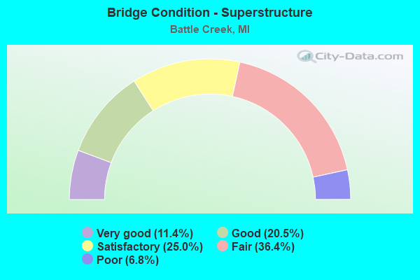
- Bridge Condition - Superstructure
- 11.4%Very good
- 20.5%Good
- 25.0%Satisfactory
- 36.4%Fair
- 6.8%Poor
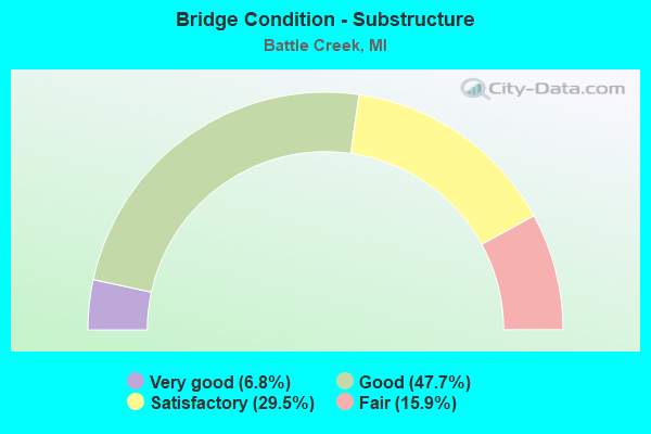
- Bridge Condition - Substructure
- 6.8%Very good
- 47.7%Good
- 29.5%Satisfactory
- 15.9%Fair
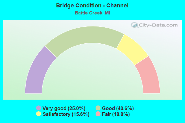
- Bridge Condition - Channel
- 25.0%Very good
- 40.6%Good
- 15.6%Satisfactory
- 18.8%Fair
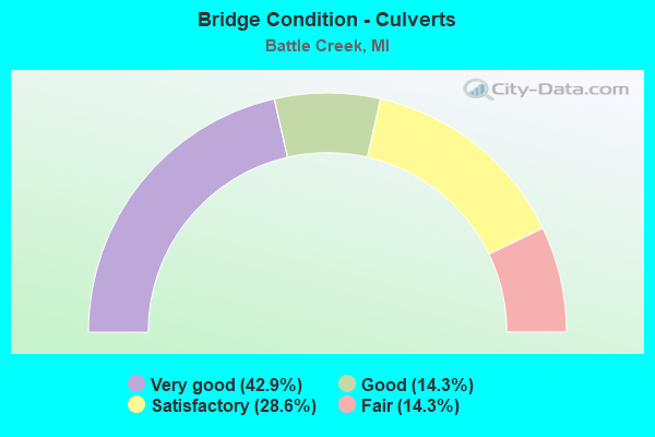
- Bridge Condition - Culverts
- 42.9%Very good
- 14.3%Good
- 28.6%Satisfactory
- 14.3%Fair
Find on map >> Show street view
Structure Number: 1408, Location: 0.3 MI S OF CAPITAL AVE (Lat: 42.318267, Lng: -85.167542), Route carried "on" structure: City street 2011, Year Built: 1980, Status: Open, Structure Length: 4.11m (13.48ft), Average Daily Traffic: 2,400 (year 2019), Truck Traffic: 4%, Average Future Daily Traffic: 4,000 (year 2036), Design Load: HS 20+Mod, Features Intersected: BATTLE CREEK RIVER, Facility Carried by Structure: UNION STREET
Minimum Vertical Clearance: 30.48m (100.00ft), Kilometerpoint: 0.623, Lanes on structure: 4, Owner: City or Municipal Highway Agency, Approaching Roadway Width: 9.8m (32.2ft), Material/Design: Prestressed concrete, Design/Construction: Box Beam or Girders - Multiple, Number Of Spans In Main Unit: 3, Length of Maximum Span: 13.7m (44.9ft), Curb or Sidewalk Widths: Left: 1.7m (5.6ft), Right: 1.7m (5.6ft), Curb-To-Curb Width: 15.8m (51.8ft), Out-to-Out Width: 21.0m (68.9ft)
Condition: Deck: Poor, Superstructure: Fair, Substructure: Satisfactory, Channel: Good, Operating Rating: 54.8 metric tons, Method Used To Determine Operating Rating: Load Factor (LF) rating reported by rating factor (RF) method using MS18 loading, Inventory Rating: 32.7 metric tons, Method Used To Determine Inventory Rating: Load Factor (LF) rating reported by rating factor (RF) method using MS18 loading, Structural Evaluation: Somewhat better than minimum adequacy, Deck Geometry: Meets minimum limits, Waterway Adequacy: Superior to present desirable criteria, Approach Roadway Alignment: Equal to present desirable criteria, Length Of Structure Improvement: 0.15m (0.49ft), Designated Inspection Frequency: Every 12 months, Inspection Date: September 2021, Bridge Improvement Cost: $10,000, Total Project Cost: $15,000, Deck Structure Type: Concrete Cast-file-Place, Wearing Surface/Protective System: Wearing Surface: Latex Concrete, Deck Protection: Other
Find on map >> Show street view
Structure Number: 1409, Location: IN BATTLE CREEK (Lat: 42.322653, Lng: -85.185733), Route carried "on" structure: City street , Year Built: 1993, Status: Open, Structure Length: 3.44m (11.29ft), Average Daily Traffic: 6,900 (year 2017), Truck Traffic: 8%, Average Future Daily Traffic: 9,600 (year 2037), Design Load: HS 20, Features Intersected: BATTLE CREEK RIVER, Facility Carried by Structure: MICHIGAN AVENUE
Minimum Vertical Clearance: 30.48m (100.00ft), Kilometerpoint: 10.704, Lanes on structure: 2, Base Highway Network: Yes (Inventory Route: 129, Subroute: 9), Owner: City or Municipal Highway Agency, Approaching Roadway Width: 11.3m (37.1ft), Material/Design: Prestressed concrete, Design/Construction: Stringer/Multi-beam, Number Of Spans In Main Unit: 3, Length of Maximum Span: 25.0m (82.0ft), Curb or Sidewalk Widths: Left: 3.0m (9.8ft), Right: 3.0m (9.8ft), Curb-To-Curb Width: 11.3m (37.1ft), Out-to-Out Width: 18.2m (59.7ft)
Condition: Deck: Very good, Superstructure: Good, Substructure: Very good, Channel: Good, Operating Rating: 89.4 metric tons, Method Used To Determine Operating Rating: Load Factor (LF) rating reported by rating factor (RF) method using MS18 loading, Inventory Rating: 50.5 metric tons, Method Used To Determine Inventory Rating: Load Factor (LF) rating reported by rating factor (RF) method using MS18 loading, Structural Evaluation: Better than present minimum criteria, Deck Geometry: Meets minimum limits, Waterway Adequacy: Superior to present desirable criteria, Approach Roadway Alignment: Equal to present minimum criteria, Designated Inspection Frequency: Every 24 months, Inspection Date: September 2021, Deck Structure Type: Concrete Cast-file-Place, Wearing Surface/Protective System: Wearing Surface: Monolithic Concrete, Deck Protection: Epoxy Coated Reinforcing
Find on map >> Show street view
Structure Number: 141, Location: 0.1 MI E OF CAPITAL AVE (Lat: 42.330433, Lng: -85.152350), Route carried "on" structure: City street 2011, Year Built: 1991, Status: Open, Structure Length: 4.75m (15.58ft), Average Daily Traffic: 10,100 (year 1995), Average Future Daily Traffic: 12,300 (year 2005), Design Load: HS 20, Features Intersected: BATTLE CREEK RIVER, Facility Carried by Structure: EMMETT STREET E
Minimum Vertical Clearance: 30.48m (100.00ft), Kilometerpoint: 3.122, Lanes on structure: 4, Owner: City or Municipal Highway Agency, Approaching Roadway Width: 19.2m (63.0ft), Skew: 1 degrees, Material/Design: Prestressed concrete, Design/Construction: Stringer/Multi-beam, Number Of Spans In Main Unit: 3, Length of Maximum Span: 15.8m (51.8ft), Curb or Sidewalk Widths: Left: 1.8m (5.9ft), Right: 1.8m (5.9ft), Curb-To-Curb Width: 15.9m (52.2ft), Out-to-Out Width: 20.2m (66.3ft)
Condition: Deck: Satisfactory, Superstructure: Good, Substructure: Good, Channel: Very good, Operating Rating: 73.9 metric tons, Method Used To Determine Operating Rating: Load Factor (LF) rating reported by rating factor (RF) method using MS18 loading, Inventory Rating: 44.1 metric tons, Method Used To Determine Inventory Rating: Load Factor (LF) rating reported by rating factor (RF) method using MS18 loading, Structural Evaluation: Better than present minimum criteria, Deck Geometry: Meets minimum limits, Waterway Adequacy: Equal to present minimum criteria, Approach Roadway Alignment: Better than present minimum criteria, Designated Inspection Frequency: Every 24 months, Inspection Date: September 2021, Deck Structure Type: Concrete Cast-file-Place, Wearing Surface/Protective System: Wearing Surface: Monolithic Concrete, Deck Protection: Other
Find on map >> Show street view
Structure Number: 1411, Location: 0.1 MI N E MICHIGAN AVE (Lat: 42.320150, Lng: -85.180653), Route carried "on" structure: City street 2011, Year Built: 1987, Status: Open, Structure Length: 3.07m (10.07ft), Average Daily Traffic: 11,100 (year 1995), Average Future Daily Traffic: 13,500 (year 2005), Design Load: HS 20+Mod, Features Intersected: BATTLE CREEK RIVER, Facility Carried by Structure: CAPITAL AVENUE N E
Minimum Vertical Clearance: 30.48m (100.00ft), Kilometerpoint: 0.161, Lanes on structure: 4, Owner: City or Municipal Highway Agency, Approaching Roadway Width: 14.0m (45.9ft), Material/Design: Prestressed concrete, Design/Construction: Stringer/Multi-beam, Number Of Spans In Main Unit: 2, Length of Maximum Span: 15.5m (50.9ft), Curb or Sidewalk Widths: Left: 2.3m (7.5ft), Right: 2.3m (7.5ft), Curb-To-Curb Width: 14.6m (47.9ft), Out-to-Out Width: 20.1m (65.9ft)
Condition: Deck: Very good, Superstructure: Very good, Substructure: Good, Channel: Good, Operating Rating: 59.6 metric tons, Method Used To Determine Operating Rating: Load Factor (LF) rating reported by rating factor (RF) method using MS18 loading, Inventory Rating: 33.4 metric tons, Method Used To Determine Inventory Rating: Load Factor (LF) rating reported by rating factor (RF) method using MS18 loading, Structural Evaluation: Better than present minimum criteria, Deck Geometry: High priority of replacement, Waterway Adequacy: Better than present minimum criteria, Approach Roadway Alignment: Somewhat better than minimum adequacy, Designated Inspection Frequency: Every 24 months, Inspection Date: September 2021, Deck Structure Type: Concrete Cast-file-Place, Wearing Surface/Protective System: Wearing Surface: Integral Concrete, Deck Protection: Epoxy Coated Reinforcing
Find on map >> Show street view
Structure Number: 1412, Location: N OF DICKMAN (I-94BL) (Lat: 42.316231, Lng: -85.188022), Route carried "on" structure: City street 2011, Year Built: 1958, Year Reconstructed: 2013, Status: Open, Structure Length: 2.13m (6.99ft), Average Daily Traffic: 16,300 (year 1993), Average Future Daily Traffic: 19,900 (year 2003), Design Load: HS 20+Mod, Features Intersected: KALAMAZOO RIVER, Facility Carried by Structure: CAPITAL AVENUE S W
Minimum Vertical Clearance: 30.48m (100.00ft), Kilometerpoint: 9.743, Lanes on structure: 4, Owner: City or Municipal Highway Agency, Approaching Roadway Width: 14.0m (45.9ft), Skew: 1 degrees, Material/Design: Steel, Design/Construction: Stringer/Multi-beam, Number Of Spans In Main Unit: 1, Length of Maximum Span: 20.1m (65.9ft), Curb or Sidewalk Widths: Left: 1.4m (4.6ft), Right: 1.4m (4.6ft), Curb-To-Curb Width: 14.0m (45.9ft), Out-to-Out Width: 17.7m (58.1ft)
Condition: Deck: Good, Superstructure: Good, Substructure: Good, Channel: Very good, Operating Rating: 87.5 metric tons, Method Used To Determine Operating Rating: Load Factor (LF) rating reported by rating factor (RF) method using MS18 loading, Inventory Rating: 52.2 metric tons, Method Used To Determine Inventory Rating: Load Factor (LF) rating reported by rating factor (RF) method using MS18 loading, Structural Evaluation: Better than present minimum criteria, Deck Geometry: High priority of replacement, Waterway Adequacy: Equal to present desirable criteria, Approach Roadway Alignment: Better than present minimum criteria, Designated Inspection Frequency: Every 24 months, Inspection Date: October 2021, Deck Structure Type: Concrete Cast-file-Place, Wearing Surface/Protective System: Wearing Surface: Latex Concrete
Find on map >> Show street view
Structure Number: 1413, Location: 1.3 MI N OF I-94 BL (Lat: 42.337972, Lng: -85.232500), Route carried "on" structure: State highway 96, Year Built: 1973, Year Reconstructed: 2006, Status: Open, Structure Length: 10.16m (33.33ft), Average Daily Traffic: 12,841 (year 2007), Truck Traffic: 5%, Average Future Daily Traffic: 16,534 (year 2018), Design Load: HS 20+Mod, Features Intersected: KALAMAZOO RIVER, Facility Carried by Structure: M-37 (BEDFORD RD)
Minimum Vertical Clearance: 30.48m (100.00ft), Kilometerpoint: 0.692, Lanes on structure: 5, Base Highway Network: Yes (Inventory Route: 131, Subroute: 8), Owner: State Highway Agency, Approaching Roadway Width: 15.8m (51.8ft), Material/Design: Prestressed concrete, Design/Construction: Stringer/Multi-beam, Number Of Spans In Main Unit: 5, Length of Maximum Span: 20.1m (65.9ft), Curb or Sidewalk Widths: Left: 2.0m (6.6ft), Right: 0.0m, Curb-To-Curb Width: 16.5m (54.1ft), Out-to-Out Width: 19.6m (64.3ft)
Condition: Deck: Satisfactory, Superstructure: Fair, Substructure: Satisfactory, Channel: Fair, Operating Rating: 57.3 metric tons, Method Used To Determine Operating Rating: Load Factor (LF) rating reported by rating factor (RF) method using MS18 loading, Inventory Rating: 34.0 metric tons, Method Used To Determine Inventory Rating: Load Factor (LF) rating reported by rating factor (RF) method using MS18 loading, Structural Evaluation: Somewhat better than minimum adequacy, Deck Geometry: High priority of replacement, Waterway Adequacy: Equal to present desirable criteria, Approach Roadway Alignment: Equal to present minimum criteria, Designated Inspection Frequency: Every 24 months, Underwater Inspection Frequency: Every 60 months, Inspection Date: July 2021, Underwater Inspection Date: August 2017, Deck Structure Type: Concrete Cast-file-Place, Wearing Surface/Protective System: Wearing Surface: Latex Concrete, Deck Protection: Epoxy Coated Reinforcing
Find on map >> Show street view
Structure Number: 12644, Location: 0.8 MI NORTH OF I-94 (Lat: 42.273564, Lng: -85.198842), Route carried "on" structure: City street , Year Built: 1995, Status: Open, Structure Length: 0.79m (2.59ft), Average Daily Traffic: 17,100 (year 1998), Truck Traffic: 2%, Average Future Daily Traffic: 20,900 (year 2008), Design Load: HS 20, Features Intersected: MINGES BROOK, Facility Carried by Structure: CAPITAL AVENUE S W
Minimum Vertical Clearance: 30.48m (100.00ft), Kilometerpoint: 4.624, Lanes on structure: 2, Owner: City or Municipal Highway Agency, Approaching Roadway Width: 11.0m (36.1ft), Material/Design: Concrete, Design/Construction: Culvert, Number Of Spans In Main Unit: 1, Length of Maximum Span: 7.3m (24.0ft), Curb or Sidewalk Widths: Left: 1.3m (4.3ft), Right: 0.0m, Curb-To-Curb Width: 8.5m (27.9ft), Out-to-Out Width: 11.0m (36.1ft)
Condition: Channel: Good, Culverts: Good, Operating Rating: 54.5 metric tons, Method Used To Determine Operating Rating: Field evaluation and documented engineering judgment, Inventory Rating: 32.7 metric tons, Method Used To Determine Inventory Rating: Field evaluation and documented engineering judgment, Structural Evaluation: Better than present minimum criteria, Deck Geometry: High priority of replacement, Waterway Adequacy: Superior to present desirable criteria, Approach Roadway Alignment: Equal to present desirable criteria, Designated Inspection Frequency: Every 24 months, Inspection Date: October 2021
Find on map >> Show street view
Structure Number: 12745, Location: IN CITY OF BATTLE CREEK (Lat: 42.331519, Lng: -85.144325), Route carried "on" structure: City street , Year Built: 1997, Status: Open, Structure Length: 16.00m (52.49ft), Average Daily Traffic: 14,700 (year 2017), Truck Traffic: 8%, Average Future Daily Traffic: 19,500 (year 2037), Design Load: HS 20, Features Intersected: CN RAILROAD, Facility Carried by Structure: EMMETT STREET
Minimum Vertical Clearance: 30.48m (100.00ft), Kilometerpoint: 3.697, Lanes on structure: 4, Owner: City or Municipal Highway Agency, Approaching Roadway Width: 14.6m (47.9ft), Skew: 3 degrees, Material/Design: Prestressed concrete, Design/Construction: Box Beam or Girders - Multiple, Number Of Spans In Main Unit: 6, Length of Maximum Span: 29.9m (98.1ft), Curb or Sidewalk Widths: Left: 3.0m (9.8ft), Right: 0.0m, Curb-To-Curb Width: 15.8m (51.8ft), Out-to-Out Width: 19.8m (65.0ft)
Condition: Deck: Good, Superstructure: Good, Substructure: Good, Operating Rating: 69.7 metric tons, Method Used To Determine Operating Rating: Load Factor (LF) rating reported by rating factor (RF) method using MS18 loading, Inventory Rating: 24.3 metric tons, Method Used To Determine Inventory Rating: Load Factor (LF) rating reported by rating factor (RF) method using MS18 loading, Structural Evaluation: Equal to present minimum criteria, Deck Geometry: Meets minimum limits, Underclear: High priority of corrective action, Approach Roadway Alignment: Equal to present desirable criteria, Designated Inspection Frequency: Every 24 months, Inspection Date: September 2021, Deck Structure Type: Concrete Cast-file-Place, Wearing Surface/Protective System: Wearing Surface: Epoxy Overlay, Deck Protection: Epoxy Coated Reinforcing
Find on map >> Show street view
Structure Number: 13434, Location: CITY OF BATTLE CREEK (Lat: 42.271611, Lng: -85.188944), Route carried "on" structure: City street , Year Built: 2008, Status: Open, Structure Length: 0.91m (2.99ft), Average Daily Traffic: 4,700 (year 2007), Truck Traffic: 2%, Average Future Daily Traffic: 14,500 (year 2027), Design Load: HS 20, Features Intersected: MINGES BROOK, Facility Carried by Structure: RIVERSIDE DRIVE
Minimum Vertical Clearance: 30.48m (100.00ft), Kilometerpoint: 1.157, Lanes on structure: 2, Owner: City or Municipal Highway Agency, Approaching Roadway Width: 10.1m (33.1ft), Material/Design: Concrete, Design/Construction: Culvert, Number Of Spans In Main Unit: 1, Length of Maximum Span: 8.5m (27.9ft), Curb or Sidewalk Widths: Left: 0.0m, Right: 1.5m (4.9ft), Curb-To-Curb Width: 10.1m (33.1ft), Out-to-Out Width: 12.8m (42.0ft)
Condition: Channel: Good, Culverts: Very good, Operating Rating: 76.8 metric tons, Method Used To Determine Operating Rating: Load Factor (LF) rating reported by rating factor (RF) method using MS18 loading, Inventory Rating: 46.0 metric tons, Method Used To Determine Inventory Rating: Load Factor (LF) rating reported by rating factor (RF) method using MS18 loading, Structural Evaluation: Equal to present desirable criteria, Deck Geometry: Meets minimum limits, Waterway Adequacy: Equal to present minimum criteria, Approach Roadway Alignment: Equal to present desirable criteria, Designated Inspection Frequency: Every 24 months, Inspection Date: October 2021, Wearing Surface/Protective System: Wearing Surface: Bituminous
Find on map >> Show street view
Structure Number: 13907, Location: EAST OF HELMER (Lat: 42.268306, Lng: -85.220694), Route carried "on" structure: City street , Year Built: 1965, Status: Open, Structure Length: 0.66m (2.17ft), Average Daily Traffic: 6,000 (year 2015), Truck Traffic: 2%, Average Future Daily Traffic: 7,500 (year 2035), Design Load: HS 20, Features Intersected: MINGES BROOK, Facility Carried by Structure: WATKINS ROAD
Minimum Vertical Clearance: 30.48m (100.00ft), Kilometerpoint: 6.925, Lanes on structure: 2, Owner: City or Municipal Highway Agency, Approaching Roadway Width: 11.0m (36.1ft), Skew: 2 degrees, Material/Design: Steel, Design/Construction: Culvert, Number Of Spans In Main Unit: 2, Length of Maximum Span: 2.7m (8.9ft), Curb-To-Curb Width: 7.3m (24.0ft), Out-to-Out Width: 22.9m (75.1ft)
Condition: Channel: Satisfactory, Culverts: Fair, Operating Rating: 44.7 metric tons, Method Used To Determine Operating Rating: Load Factor (LF) rating reported by rating factor (RF) method using MS18 loading, Inventory Rating: 26.9 metric tons, Method Used To Determine Inventory Rating: Load Factor (LF) rating reported by rating factor (RF) method using MS18 loading, Structural Evaluation: Somewhat better than minimum adequacy, Deck Geometry: High priority of replacement, Waterway Adequacy: Equal to present desirable criteria, Approach Roadway Alignment: Equal to present minimum criteria, Designated Inspection Frequency: Every 24 months, Inspection Date: October 2021, Wearing Surface/Protective System: Wearing Surface: Bituminous, Deck Protection: Other
Find on map >> Show street view
Structure Number: 13908, Location: 500 FT N OF ABRAM AVE (Lat: 42.274806, Lng: -85.208694), Route carried "on" structure: City street , Year Built: 2014, Status: Open, Structure Length: 0.78m (2.56ft), Average Daily Traffic: 3,000 (year 2014), Truck Traffic: 2%, Average Future Daily Traffic: 4,500 (year 2034), Design Load: HS 20, Features Intersected: MINGES BROOK, Facility Carried by Structure: SOUTH MINGES ROAD
Minimum Vertical Clearance: 30.48m (100.00ft), Kilometerpoint: 1.242, Lanes on structure: 2, Owner: City or Municipal Highway Agency, Approaching Roadway Width: 10.1m (33.1ft), Skew: 1 degrees, Material/Design: Concrete, Design/Construction: Culvert, Number Of Spans In Main Unit: 1, Length of Maximum Span: 7.3m (24.0ft), Curb or Sidewalk Widths: Left: 2.0m (6.6ft), Right: 2.1m (6.9ft), Curb-To-Curb Width: 9.8m (32.2ft), Out-to-Out Width: 14.6m (47.9ft)
Condition: Channel: Good, Culverts: Very good, Operating Rating: 63.2 metric tons, Method Used To Determine Operating Rating: Load and Resistance Factor Rating (LRFR) rating reported by rating factor(RF) method using HL-93 loadings, Inventory Rating: 48.9 metric tons, Method Used To Determine Inventory Rating: Load and Resistance Factor Rating (LRFR) rating reported by rating factor(RF) method using HL-93 loadings, Structural Evaluation: Equal to present desirable criteria, Deck Geometry: Meets minimum limits, Waterway Adequacy: Equal to present desirable criteria, Approach Roadway Alignment: Equal to present desirable criteria, Designated Inspection Frequency: Every 24 months, Inspection Date: October 2021, Wearing Surface/Protective System: Wearing Surface: Bituminous
Find on map >> Show street view
Structure Number: 14335, Location: 500 FT W OF 8 MI RD (Lat: 42.275700, Lng: -85.155600), Route carried "on" structure: County highway , Year Built: 2019, Status: Open, Structure Length: 0.98m (3.22ft), Average Daily Traffic: 1,200 (year 2019), Truck Traffic: 5%, Average Future Daily Traffic: 1,380 (year 2039), Design Load: Greater than HL93, Features Intersected: HARPER CREEK, Facility Carried by Structure: D DRIVE N
Minimum Vertical Clearance: 30.48m (100.00ft), Kilometerpoint: 1.307, Lanes on structure: 2, Owner: County Highway Agency, Approaching Roadway Width: 7.9m (25.9ft), Skew: 2 degrees, Material/Design: Concrete, Design/Construction: Culvert, Number Of Spans In Main Unit: 1, Length of Maximum Span: 9.8m (32.2ft), Curb-To-Curb Width: 8.2m (26.9ft), Out-to-Out Width: 8.2m (26.9ft)
Condition: Channel: Good, Culverts: Very good, Operating Rating: 64.8 metric tons, Method Used To Determine Operating Rating: Load and Resistance Factor Rating (LRFR) rating reported by rating factor(RF) method using HL-93 loadings, Inventory Rating: 50.9 metric tons, Method Used To Determine Inventory Rating: Load and Resistance Factor Rating (LRFR) rating reported by rating factor(RF) method using HL-93 loadings, Structural Evaluation: Equal to present desirable criteria, Deck Geometry: Meets minimum limits, Waterway Adequacy: Equal to present desirable criteria, Approach Roadway Alignment: Better than present minimum criteria, Designated Inspection Frequency: Every 24 months, Inspection Date: July 2021, Wearing Surface/Protective System: Wearing Surface: Bituminous
Find on map >> Show street view
Structure Number: AFMIMBMV07001, Location: 0.3 MILES EAST OF GATE AT (Lat: 42.309972, Lng: -85.260111), Route carried "on" structure: Other road , Year Built: 2002, Status: Open, Structure Length: 5.79m (19.00ft), Average Daily Traffic: 150 (year 2020), Average Future Daily Traffic: 180 (year 2040), Design Load: HS 25 or greater, Features Intersected: CANADIAN NATIONAL RAILRO, Facility Carried by Structure: SENTRY DRIVE
Minimum Vertical Clearance: 30+ m (98+ ft), Kilometerpoint: 0.000, Lanes on structure: 2, Owner: Air Force, Approaching Roadway Width: 7.4m (24.3ft), Material/Design: Prestressed concrete, Design/Construction: Box Beam or Girders - Multiple, Number Of Spans In Main Unit: 3, Length of Maximum Span: 21.3m (69.9ft), Curb-To-Curb Width: 10.9m (35.8ft), Out-to-Out Width: 11.9m (39.0ft)
Condition: Deck: Satisfactory, Superstructure: Satisfactory, Substructure: Good, Operating Rating: 73.5 metric tons, Method Used To Determine Operating Rating: Load Factor (LF), Inventory Rating: 47.2 metric tons, Method Used To Determine Inventory Rating: Load Factor (LF), Structural Evaluation: Equal to present minimum criteria, Deck Geometry: Better than present minimum criteria, Approach Roadway Alignment: Equal to present minimum criteria, Designated Inspection Frequency: Every 24 months, Inspection Date: September 2020, Deck Structure Type: Concrete Cast-file-Place
Find on map >> Show street view
Structure Number: 1205, Location: 1.7 MI N OF I-94 (Lat: 42.293750, Lng: -85.178767), Route carried "under" structure: County highway 2011, Year Built: 1960, Structure Length: 0. m, Average Daily Traffic: 3,904 (year 1996), Truck Traffic: 3%, Features Intersected: GOLDEN AVE, Facility Carried by Structure: I-194 NB
Minimum Vertical Clearance: 5.11m (16.77ft), Kilometerpoint: 1.691, Lanes on structure: 3, Lanes under structure: 2, Material/Design: Concrete continuous, Design/Construction: Tee Beam, Length of Maximum Span: 15.5m (50.9ft)
Find on map >> Show street view
Structure Number: 1206, Location: 1.7 MI N OF I-94 (Lat: 42.293747, Lng: -85.179136), Route carried "under" structure: County highway 2011, Year Built: 1960, Structure Length: 0. m, Average Daily Traffic: 3,904 (year 1996), Truck Traffic: 3%, Features Intersected: GOLDEN AVE, Facility Carried by Structure: I-194 SB
Minimum Vertical Clearance: 4.65m (15.26ft), Kilometerpoint: 1.661, Lanes on structure: 2, Lanes under structure: 2, Material/Design: Concrete continuous, Design/Construction: Tee Beam, Length of Maximum Span: 15.5m (50.9ft)
Find on map >> Show street view
Structure Number: 1207, Location: 2.1 MI N OF I-94 (Lat: 42.298489, Lng: -85.180297), Route carried "under" structure: Interstate 194, Year Built: 1965, Structure Length: 0. m, Average Daily Traffic: 26,282 (year 2007), Truck Traffic: 6%, Features Intersected: I-194, Facility Carried by Structure: M-96 (COLUMBIA)
Minimum Vertical Clearance: 5.03m (16.50ft), Kilometerpoint: 4.930, Lanes on structure: 5, Lanes under structure: 4, Material/Design: Steel, Design/Construction: Stringer/Multi-beam, Length of Maximum Span: 28.2m (92.5ft)
Find on map >> Show street view
Structure Number: 1208, Location: 2.8 MI N OF I-94 (Lat: 42.308644, Lng: -85.185014), Route carried "under" structure: City street , Year Built: 1966, Structure Length: 0. m, Average Daily Traffic: 3,100 (year 1988), Features Intersected: BURNHAM ST, Facility Carried by Structure: I-194
Minimum Vertical Clearance: 4.52m (14.83ft), Kilometerpoint: 0.940, Lanes on structure: 6, Lanes under structure: 2, Material/Design: Prestressed concrete, Design/Construction: Stringer/Multi-beam, Length of Maximum Span: 20.7m (67.9ft)
Find on map >> Show street view
Structure Number: 1209, Location: 3.1 MI N OF I-94 (Lat: 42.311847, Lng: -85.182014), Route carried "under" structure: Business Interstate 94, Year Built: 1966, Structure Length: 0. m, Average Daily Traffic: 10,200 (year 2013), Truck Traffic: 7%, Features Intersected: I-94 BL (DICKMAN ROAD)
Minimum Vertical Clearance: 6.10m (20.01ft), Kilometerpoint: 11.037, Lanes on structure: 5, Lanes under structure: 4, Material/Design: Steel, Design/Construction: Stringer/Multi-beam, Length of Maximum Span: 22.2m (72.8ft)
Find on map >> Show street view
Structure Number: 121, Location: 3.3 MI N OF I-94 (Lat: 42.314389, Lng: -85.180867), Route carried "under" structure: City street , Year Built: 1966, Structure Length: 0. m, Average Daily Traffic: 12,200 (year 2013), Features Intersected: FOUNTAIN STREET, Facility Carried by Structure: I-194
Minimum Vertical Clearance: 4.62m (15.16ft), Kilometerpoint: 1.574, Lanes on structure: 5, Lanes under structure: 2, Material/Design: Steel, Design/Construction: Stringer/Multi-beam, Length of Maximum Span: 21.9m (71.9ft)
Find on map >> Show street view
Structure Number: 1248, Location: 0.1 MI E OF KALAMAZOO COL (Lat: 42.272683, Lng: -85.295483), Route carried "under" structure: Interstate 94, Year Built: 2015, Structure Length: 0. m, Average Daily Traffic: 46,751 (year 2014), Truck Traffic: 23%, Features Intersected: I-94
Minimum Vertical Clearance: 5.18m (16.99ft), Kilometerpoint: 0.117, Lanes on structure: 3, Lanes under structure: 5, Material/Design: Prestressed concrete, Design/Construction: Stringer/Multi-beam, Length of Maximum Span: 38.8m (127.3ft)
Find on map >> Show street view
Structure Number: 1249, Location: 1.0 MI E OF KALAMAZOO COL (Lat: 42.269481, Lng: -85.278583), Route carried "under" structure: Interstate 94, Year Built: 1959, Structure Length: 0. m, Average Daily Traffic: 48,196 (year 2007), Truck Traffic: 22%, Features Intersected: I-94, Facility Carried by Structure: RENTON ROAD
Minimum Vertical Clearance: 5.08m (16.67ft), Kilometerpoint: 1.569, Lanes on structure: 2, Lanes under structure: 4, Material/Design: Concrete continuous, Design/Construction: Tee Beam, Length of Maximum Span: 22.8m (74.8ft)
Find on map >> Show street view
Structure Number: 125, Location: 3.0 MI E OF KALAMAZOO COL (Lat: 42.265300, Lng: -85.237953), Route carried "under" structure: Interstate 94, Year Built: 1959, Structure Length: 0. m, Average Daily Traffic: 49,460 (year 2007), Truck Traffic: 23%, Features Intersected: I-94, Facility Carried by Structure: HELMER ROAD
Minimum Vertical Clearance: 5.18m (16.99ft), Kilometerpoint: 4.989, Lanes on structure: 2, Lanes under structure: 4, Material/Design: Concrete continuous, Design/Construction: Tee Beam, Length of Maximum Span: 22.6m (74.1ft)
Find on map >> Show street view
Structure Number: 1251, Location: 5.0 MI E OF KALAMAZOO COL (Lat: 42.261836, Lng: -85.198592), Route carried "under" structure: Interstate 94, Year Built: 1959, Structure Length: 0. m, Average Daily Traffic: 54,648 (year 2007), Truck Traffic: 23%, Features Intersected: I-94, Facility Carried by Structure: CAPITAL AVE
Minimum Vertical Clearance: 4.93m (16.17ft), Kilometerpoint: 8.263, Lanes on structure: 5, Lanes under structure: 4, Material/Design: Prestressed concrete, Design/Construction: Box Beam or Girders - Multiple, Length of Maximum Span: 23.6m (77.4ft)
Find on map >> Show street view
Structure Number: 1252, Location: 0.5 MI W OF M-66 (Lat: 42.262864, Lng: -85.188875), Route carried "under" structure: County highway 2011, Year Built: 2009, Structure Length: 0. m, Average Daily Traffic: 7,916 (year 2005), Truck Traffic: 2%, Features Intersected: RIVERSIDE DRIVE, Facility Carried by Structure: I-94 EB
Minimum Vertical Clearance: 5.38m (17.65ft), Kilometerpoint: 0.203, Lanes on structure: 2, Lanes under structure: 3, Material/Design: Prestressed concrete, Design/Construction: Box Beam or Girders - Single/Spread, Length of Maximum Span: 18.3m (60.0ft)
Find on map >> Show street view
Structure Number: 1253, Location: 0.5 MI W OF M-66 (Lat: 42.263153, Lng: -85.188878), Route carried "under" structure: County highway 2011, Year Built: 2009, Structure Length: 0. m, Average Daily Traffic: 7,916 (year 2005), Truck Traffic: 3%, Features Intersected: RIVERSIDE DRIVE, Facility Carried by Structure: I-94 WB
Minimum Vertical Clearance: 4.70m (15.42ft), Kilometerpoint: 0.233, Lanes on structure: 2, Lanes under structure: 3, Material/Design: Prestressed concrete, Design/Construction: Box Beam or Girders - Single/Spread, Length of Maximum Span: 18.3m (60.0ft)
Find on map >> Show street view
Structure Number: 1254, Location: AT M-66 (Lat: 42.268489, Lng: -85.178483), Route carried "under" structure: Interstate 94, Year Built: 1960, Structure Length: 0. m, Average Daily Traffic: 54,648 (year 2007), Truck Traffic: 23%, Features Intersected: I-94
Minimum Vertical Clearance: 6.00m (19.69ft), Kilometerpoint: 10.118, Lanes on structure: 3, Lanes under structure: 6, Material/Design: Steel continuous, Design/Construction: Stringer/Multi-beam, Length of Maximum Span: 34.4m (112.9ft)
Find on map >> Show street view
Structure Number: 1255, Location: AT M-66 (Lat: 42.268228, Lng: -85.178925), Route carried "under" structure: Interstate 94, Year Built: 1960, Structure Length: 0. m, Average Daily Traffic: 54,648 (year 2007), Truck Traffic: 23%, Features Intersected: I-94
Minimum Vertical Clearance: 5.61m (18.41ft), Kilometerpoint: 10.070, Lanes on structure: 3, Lanes under structure: 6, Material/Design: Steel continuous, Design/Construction: Stringer/Multi-beam, Length of Maximum Span: 34.4m (112.9ft)
Find on map >> Show street view
Structure Number: 1261, Location: 0.5 MI E OF M-66 (Lat: 42.273511, Lng: -85.169331), Route carried "under" structure: County highway 2011, Year Built: 1959, Structure Length: 0. m, Average Daily Traffic: 450 (year 1974), Truck Traffic: 3%, Features Intersected: 6 1/2 MILE ROAD, Facility Carried by Structure: I-94 EB
Minimum Vertical Clearance: 5.36m (17.59ft), Kilometerpoint: 7.793, Lanes on structure: 2, Lanes under structure: 2, Material/Design: Concrete continuous, Design/Construction: Tee Beam, Length of Maximum Span: 18.5m (60.7ft)
Find on map >> Show street view
Structure Number: 1262, Location: 0.5 MI E OF M-66 (Lat: 42.273847, Lng: -85.169339), Route carried "under" structure: County highway 2011, Year Built: 1959, Structure Length: 0. m, Average Daily Traffic: 450 (year 1974), Truck Traffic: 3%, Features Intersected: 6 1/2 MILE ROAD, Facility Carried by Structure: I-94 WB
Minimum Vertical Clearance: 4.85m (15.91ft), Kilometerpoint: 7.830, Lanes on structure: 2, Lanes under structure: 2, Material/Design: Concrete continuous, Design/Construction: Tee Beam, Length of Maximum Span: 18.5m (60.7ft)
Find on map >> Show street view
Structure Number: 1263, Location: 1.5 MI E OF M-66 (Lat: 42.281428, Lng: -85.155889), Route carried "under" structure: State highway 294, Year Built: 1959, Structure Length: 0. m, Average Daily Traffic: 5,960 (year 2010), Truck Traffic: 4%, Features Intersected: M-294 BEADLE LAKE, Facility Carried by Structure: I-94 EB
Minimum Vertical Clearance: 4.67m (15.32ft), Kilometerpoint: 3.972, Lanes on structure: 2, Lanes under structure: 2, Material/Design: Concrete, Design/Construction: Tee Beam, Length of Maximum Span: 13.4m (44.0ft)
Find on map >> Show street view
Structure Number: 1264, Location: 1.5 MI E OF M-66 (Lat: 42.281708, Lng: -85.155994), Route carried "under" structure: State highway 294, Year Built: 1959, Structure Length: 0. m, Average Daily Traffic: 5,960 (year 2010), Truck Traffic: 4%, Features Intersected: M-294 BEADLE LAKE, Facility Carried by Structure: I-94 WB
Minimum Vertical Clearance: 4.65m (15.26ft), Kilometerpoint: 4.004, Lanes on structure: 2, Lanes under structure: 2, Material/Design: Concrete, Design/Construction: Tee Beam, Length of Maximum Span: 13.4m (44.0ft)
Find on map >> Show street view
Structure Number: 1309, Location: 1.9 MI E OF I-194 (Lat: 42.309681, Lng: -85.145322), Route carried "under" structure: County highway , Year Built: 2014, Structure Length: 0. m, Average Daily Traffic: 1,506 (year 1987), Features Intersected: RAYMOND RD, Facility Carried by Structure: M-96 (COLUMBIA)
Minimum Vertical Clearance: 4.47m (14.67ft), Kilometerpoint: 1.606, Lanes on structure: 3, Lanes under structure: 2, Material/Design: Concrete, Design/Construction: Box Beam or Girders - Single/Spread, Length of Maximum Span: 16.8m (55.1ft)