Bridge Statistics for Bellevue, Wisconsin (WI)
Condition, Traffic, Stress, Structural Evaluation, Project Costs
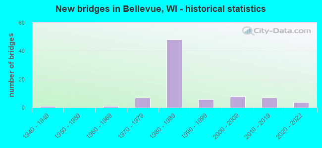
- New bridges - historical statistics
- 11940-1949
- 11960-1969
- 71970-1979
- 481980-1989
- 61990-1999
- 82000-2009
- 72010-2019
- 42020-2022

- Reconstructed bridges - Historical Statistics
- 11990-1999
- 02000-2009
- 12010-2019


- Bridge Condition - Deck
- 3.0%Excellent
- 21.2%Very good
- 57.6%Good
- 12.1%Satisfactory
- 6.1%Fair

- Bridge Condition - Superstructure
- 2.8%Excellent
- 38.9%Very good
- 27.8%Good
- 27.8%Satisfactory
- 2.8%Fair

- Bridge Condition - Substructure
- 5.6%Excellent
- 16.7%Very good
- 30.6%Good
- 47.2%Satisfactory

- Bridge Condition - Channel
- 8.1%Excellent
- 51.4%Very good
- 13.5%Good
- 24.3%Satisfactory
- 2.7%Poor

- Bridge Condition - Culverts
- 26.1%Very good
- 47.8%Good
- 26.1%Satisfactory
Find on map >> Show street view
Structure Number: B050406, Location: 0.8 MI S JCT STH 172 (Lat: 44.445611, Lng: -88.000944), Route carried "on" structure: County highway , Year Built: 2012, Status: Open, Structure Length: 0.80m (2.62ft), Average Daily Traffic: 14,150 (year 2019), Average Future Daily Traffic: 21,050 (year 2035), Design Load: HL 93, Features Intersected: BOWER CREEK TRIBUTARY, Facility Carried by Structure: CTH GV/MONROE RD.
Minimum Vertical Clearance: 30+ m (98+ ft), Kilometerpoint: 0.000, Lanes on structure: 4, Owner: County Highway Agency, Approaching Roadway Width: 25.9m (85.0ft), Skew: 1 degrees, Material/Design: Concrete, Design/Construction: Culvert, Number Of Spans In Main Unit: 2, Length of Maximum Span: 3.7m (12.1ft), Curb or Sidewalk Widths: Left: 2.0m (6.6ft), Right: 0.0m, Curb-To-Curb Width: 25.9m (85.0ft), Out-to-Out Width: 35.4m (116.1ft)
Condition: Channel: Good, Culverts: Good, Operating Rating: 43.9 metric tons, Method Used To Determine Operating Rating: Field evaluation and documented engineering judgment, Inventory Rating: 34.2 metric tons, Method Used To Determine Inventory Rating: Field evaluation and documented engineering judgment, Structural Evaluation: Better than present minimum criteria, Deck Geometry: Superior to present desirable criteria, Waterway Adequacy: Equal to present desirable criteria, Approach Roadway Alignment: Equal to present desirable criteria, Designated Inspection Frequency: Every 48 months, Inspection Date: November 2019, Deck Structure Type: Concrete Cast-file-Place, Wearing Surface/Protective System: Wearing Surface: Bituminous
Find on map >> Show street view
Structure Number: B05041, Location: .8 M N JCT CTH EE (Lat: 44.456597, Lng: -88.150042), Route carried "on" structure: County highway , Year Built: 2016, Status: Open, Structure Length: 1.11m (3.64ft), Average Daily Traffic: 2,160 (year 2019), Truck Traffic: 3%, Average Future Daily Traffic: 2,350 (year 2036), Design Load: HL 93, Features Intersected: DUTCHMANS CREEK, Facility Carried by Structure: CTH GE NB
Minimum Vertical Clearance: 30+ m (98+ ft), Kilometerpoint: 0.000, Lanes on structure: 2, Owner: City or Municipal Highway Agency, Approaching Roadway Width: 11.0m (36.1ft), Skew: 1 degrees, Material/Design: Concrete, Design/Construction: Slab, Number Of Spans In Main Unit: 1, Length of Maximum Span: 10.4m (34.1ft), Curb-To-Curb Width: 10.4m (34.1ft), Out-to-Out Width: 11.1m (36.4ft)
Condition: Deck: Very good, Superstructure: Very good, Substructure: Very good, Channel: Very good, Operating Rating: 45.0 metric tons, Method Used To Determine Operating Rating: Load and Resistance Factor Rating (LRFR) rating reported by rating factor(RF) method using HL-93 loadings, Inventory Rating: 34.3 metric tons, Method Used To Determine Inventory Rating: Load and Resistance Factor Rating (LRFR) rating reported by rating factor(RF) method using HL-93 loadings, Structural Evaluation: Equal to present desirable criteria, Deck Geometry: Somewhat better than minimum adequacy, Waterway Adequacy: Equal to present desirable criteria, Approach Roadway Alignment: Equal to present desirable criteria, Designated Inspection Frequency: Every 48 months, Inspection Date: November 2020, Deck Structure Type: Concrete Cast-file-Place, Wearing Surface/Protective System: Wearing Surface: Monolithic Concrete
Find on map >> Show street view
Structure Number: B050418, Location: 0.3M S JCT CTH V (Lat: 44.450031, Lng: -87.983578), Route carried "on" structure: City street , Year Built: 2016, Status: Open, Structure Length: 1.52m (4.99ft), Average Daily Traffic: 1,200 (year 2019), Average Future Daily Traffic: 1,900 (year 2039), Design Load: HL 93, Features Intersected: BOWER CREEK, Facility Carried by Structure: LRD BOWER CREEK RD
Minimum Vertical Clearance: 30+ m (98+ ft), Kilometerpoint: 0.000, Lanes on structure: 2, Owner: City or Municipal Highway Agency, Approaching Roadway Width: 10.4m (34.1ft), Material/Design: Concrete, Design/Construction: Slab, Number Of Spans In Main Unit: 1, Length of Maximum Span: 14.5m (47.6ft), Curb or Sidewalk Widths: Left: 1.9m (6.2ft), Right: 1.9m (6.2ft), Curb-To-Curb Width: 10.4m (34.1ft), Out-to-Out Width: 14.8m (48.6ft)
Condition: Deck: Very good, Superstructure: Very good, Substructure: Very good, Channel: Very good, Operating Rating: 49.9 metric tons, Method Used To Determine Operating Rating: Load and Resistance Factor Rating (LRFR) rating reported by rating factor(RF) method using HL-93 loadings, Inventory Rating: 38.6 metric tons, Method Used To Determine Inventory Rating: Load and Resistance Factor Rating (LRFR) rating reported by rating factor(RF) method using HL-93 loadings, Structural Evaluation: Equal to present desirable criteria, Deck Geometry: Equal to present minimum criteria, Waterway Adequacy: Equal to present desirable criteria, Approach Roadway Alignment: Equal to present desirable criteria, Designated Inspection Frequency: Every 48 months, Inspection Date: September 2020, Deck Structure Type: Concrete Cast-file-Place, Wearing Surface/Protective System: Wearing Surface: Monolithic Concrete
Find on map >> Show street view
Structure Number: B050431, Location: 100' N OF PINE GROVE ROAD (Lat: 44.415528, Lng: -87.954333), Route carried "on" structure: County highway G, Year Built: 2012, Status: Open, Structure Length: 0.62m (2.03ft), Average Daily Traffic: 2,200 (year 2019), Average Future Daily Traffic: 2,300 (year 2038), Design Load: HS 20, Features Intersected: BOWER CREEK TRIBUTARY
Minimum Vertical Clearance: 30+ m (98+ ft), Kilometerpoint: 0.000, Lanes on structure: 2, Owner: County Highway Agency, Approaching Roadway Width: 12.8m (42.0ft), Material/Design: Aluminum, Iron, Design/Construction: Culvert, Number Of Spans In Main Unit: 1, Length of Maximum Span: 6.2m (20.3ft), Curb-To-Curb Width: 12.8m (42.0ft), Out-to-Out Width: 21.3m (69.9ft)
Condition: Channel: Very good, Culverts: Very good, Operating Rating: 53.9 metric tons, Method Used To Determine Operating Rating: Field evaluation and documented engineering judgment, Inventory Rating: 32.4 metric tons, Method Used To Determine Inventory Rating: Field evaluation and documented engineering judgment, Structural Evaluation: Equal to present desirable criteria, Deck Geometry: Equal to present minimum criteria, Waterway Adequacy: Equal to present desirable criteria, Approach Roadway Alignment: Equal to present desirable criteria, Designated Inspection Frequency: Every 48 months, Inspection Date: November 2019, Deck Structure Type: Aluminum, Wearing Surface/Protective System: Wearing Surface: Bituminous
Find on map >> Show street view
Structure Number: B050436, Location: 1.1M E JCT CTH G (Lat: 44.422503, Lng: -87.939881), Route carried "on" structure: County highway , Year Built: 2018, Status: Open, Structure Length: 2.15m (7.05ft), Average Daily Traffic: 1,500 (year 2018), Truck Traffic: 5%, Average Future Daily Traffic: 2,100 (year 2038), Design Load: HL 93, Features Intersected: BOWER CREEK, Facility Carried by Structure: CTH MM
Minimum Vertical Clearance: 30+ m (98+ ft), Kilometerpoint: 0.000, Lanes on structure: 2, Owner: County Highway Agency, Approaching Roadway Width: 10.4m (34.1ft), Material/Design: Concrete continuous, Design/Construction: Slab, Number Of Spans In Main Unit: 2, Length of Maximum Span: 10.4m (34.1ft), Curb-To-Curb Width: 10.4m (34.1ft), Out-to-Out Width: 11.1m (36.4ft)
Condition: Deck: Very good, Superstructure: Very good, Substructure: Excellent, Channel: Very good, Operating Rating: 52.8 metric tons, Method Used To Determine Operating Rating: Load and Resistance Factor Rating (LRFR) rating reported by rating factor(RF) method using HL-93 loadings, Inventory Rating: 40.8 metric tons, Method Used To Determine Inventory Rating: Load and Resistance Factor Rating (LRFR) rating reported by rating factor(RF) method using HL-93 loadings, Structural Evaluation: Equal to present desirable criteria, Deck Geometry: Equal to present minimum criteria, Waterway Adequacy: Equal to present desirable criteria, Approach Roadway Alignment: Equal to present desirable criteria, Designated Inspection Frequency: Every 48 months, Inspection Date: November 2020, Deck Structure Type: Concrete Cast-file-Place, Wearing Surface/Protective System: Wearing Surface: Monolithic Concrete
Find on map >> Show street view
Structure Number: B050441, Location: 1.2M S JCT CTH GV (Lat: 44.448000, Lng: -87.975700), Route carried "on" structure: County highway , Year Built: 2020, Status: Open, Structure Length: 2.64m (8.66ft), Average Daily Traffic: 1,900 (year 2019), Truck Traffic: 6%, Average Future Daily Traffic: 2,200 (year 2039), Design Load: HL 93, Features Intersected: BOWER CREEK, Facility Carried by Structure: CTH V
Minimum Vertical Clearance: 30+ m (98+ ft), Kilometerpoint: 0.000, Lanes on structure: 2, Owner: County Highway Agency, Approaching Roadway Width: 11.0m (36.1ft), Material/Design: Concrete continuous, Design/Construction: Slab, Number Of Spans In Main Unit: 2, Length of Maximum Span: 12.8m (42.0ft), Curb-To-Curb Width: 11.0m (36.1ft), Out-to-Out Width: 11.7m (38.4ft)
Condition: Deck: Excellent, Superstructure: Excellent, Substructure: Excellent, Channel: Excellent, Operating Rating: 44.7 metric tons, Method Used To Determine Operating Rating: Load and Resistance Factor Rating (LRFR) rating reported by rating factor(RF) method using HL-93 loadings, Inventory Rating: 34.3 metric tons, Method Used To Determine Inventory Rating: Load and Resistance Factor Rating (LRFR) rating reported by rating factor(RF) method using HL-93 loadings, Structural Evaluation: Superior to present desirable criteria, Deck Geometry: Equal to present minimum criteria, Waterway Adequacy: Superior to present desirable criteria, Approach Roadway Alignment: Equal to present desirable criteria, Designated Inspection Frequency: Every 24 months, Inspection Date: November 2020, Deck Structure Type: Concrete Cast-file-Place, Wearing Surface/Protective System: Wearing Surface: Monolithic Concrete
Find on map >> Show street view
Structure Number: B05047, Location: 0.2M SOUTH OF JCT CTH JJ (Lat: 44.467778, Lng: -87.975500), Route carried "on" structure: City street , Year Built: 2004, Status: Open, Structure Length: 1.28m (4.20ft), Average Daily Traffic: 1,500 (year 2020), Truck Traffic: 1%, Average Future Daily Traffic: 2,000 (year 2040), Design Load: HS 20, Features Intersected: WILLOW CREEK, Facility Carried by Structure: LRD GUNS STREET
Minimum Vertical Clearance: 30+ m (98+ ft), Kilometerpoint: 0.000, Lanes on structure: 2, Owner: City or Municipal Highway Agency, Approaching Roadway Width: 11.3m (37.1ft), Material/Design: Steel, Design/Construction: Arch - Deck, Number Of Spans In Main Unit: 3, Length of Maximum Span: 3.7m (12.1ft), Curb-To-Curb Width: 11.3m (37.1ft), Out-to-Out Width: 20.7m (67.9ft)
Condition: Superstructure: Satisfactory, Substructure: Good, Channel: Satisfactory, Operating Rating: 53.9 metric tons, Method Used To Determine Operating Rating: Field evaluation and documented engineering judgment, Inventory Rating: 32.4 metric tons, Method Used To Determine Inventory Rating: Field evaluation and documented engineering judgment, Structural Evaluation: Equal to present minimum criteria, Deck Geometry: Equal to present minimum criteria, Waterway Adequacy: Equal to present desirable criteria, Approach Roadway Alignment: Equal to present desirable criteria, Designated Inspection Frequency: Every 24 months, Inspection Date: January 2021
Find on map >> Show street view
Structure Number: B050471, Location: 0.5M SOUTH OF JCT CTH JJ (Lat: 44.460500, Lng: -87.942889), Route carried "on" structure: City street , Year Built: 1993, Status: Open, Structure Length: 0.69m (2.26ft), Average Daily Traffic: 9,100 (year 2019), Truck Traffic: 2%, Average Future Daily Traffic: 12,000 (year 2039), Design Load: HS 20, Features Intersected: SPRING CREEK, Facility Carried by Structure: LRD MANITOWOC ROAD
Minimum Vertical Clearance: 30+ m (98+ ft), Kilometerpoint: 0.000, Lanes on structure: 2, Owner: City or Municipal Highway Agency, Approaching Roadway Width: 12.5m (41.0ft), Material/Design: Concrete, Design/Construction: Culvert, Number Of Spans In Main Unit: 2, Length of Maximum Span: 3.3m (10.8ft), Curb or Sidewalk Widths: Left: 2.0m (6.6ft), Right: 2.0m (6.6ft), Curb-To-Curb Width: 12.5m (41.0ft), Out-to-Out Width: 38.3m (125.7ft)
Condition: Channel: Satisfactory, Culverts: Good, Operating Rating: 53.9 metric tons, Method Used To Determine Operating Rating: Field evaluation and documented engineering judgment, Inventory Rating: 32.4 metric tons, Method Used To Determine Inventory Rating: Field evaluation and documented engineering judgment, Structural Evaluation: Better than present minimum criteria, Deck Geometry: Somewhat better than minimum adequacy, Waterway Adequacy: Equal to present desirable criteria, Approach Roadway Alignment: Equal to present desirable criteria, Designated Inspection Frequency: Every 24 months, Inspection Date: November 2020, Wearing Surface/Protective System: Wearing Surface: Bituminous
Find on map >> Show street view
Structure Number: B050472, Location: 0.1M SOUTH OF JCT USH 141 (Lat: 44.449194, Lng: -87.937111), Route carried "on" structure: City street , Year Built: 2005, Status: Open, Structure Length: 0.67m (2.20ft), Average Daily Traffic: 1,000 (year 2020), Truck Traffic: 1%, Average Future Daily Traffic: 1,300 (year 2039), Design Load: HS 20, Features Intersected: SORENSON CREEK, Facility Carried by Structure: LRD SANTA MONICA D
Minimum Vertical Clearance: 30+ m (98+ ft), Kilometerpoint: 0.000, Lanes on structure: 2, Owner: City or Municipal Highway Agency, Approaching Roadway Width: 11.3m (37.1ft), Skew: 1 degrees, Material/Design: Aluminum, Iron, Design/Construction: Arch - Deck, Number Of Spans In Main Unit: 1, Length of Maximum Span: 6.7m (22.0ft), Curb-To-Curb Width: 11.3m (37.1ft), Out-to-Out Width: 32.6m (107.0ft)
Condition: Superstructure: Good, Substructure: Good, Channel: Very good, Operating Rating: 53.9 metric tons, Method Used To Determine Operating Rating: Field evaluation and documented engineering judgment, Inventory Rating: 32.4 metric tons, Method Used To Determine Inventory Rating: Field evaluation and documented engineering judgment, Structural Evaluation: Better than present minimum criteria, Deck Geometry: Better than present minimum criteria, Waterway Adequacy: Superior to present desirable criteria, Approach Roadway Alignment: Equal to present desirable criteria, Designated Inspection Frequency: Every 24 months, Inspection Date: November 2020, Wearing Surface/Protective System: Wearing Surface: Bituminous
Find on map >> Show street view
Structure Number: B050475, Location: 0.6 MI W OF IH 43 (Lat: 44.415028, Lng: -87.914611), Route carried "on" structure: City street , Year Built: 2021, Status: Open, Structure Length: 0.62m (2.03ft), Average Daily Traffic: 99 (year 2019), Design Load: HS 20, Features Intersected: UNNAMED CREEK, Facility Carried by Structure: LRD PINE GROVE ROA
Minimum Vertical Clearance: 30+ m (98+ ft), Kilometerpoint: 0.000, Lanes on structure: 2, Owner: Town or Township Highway Agency, Approaching Roadway Width: 6.7m (22.0ft), Material/Design: Aluminum, Iron, Design/Construction: Culvert, Number Of Spans In Main Unit: 1, Length of Maximum Span: 6.2m (20.3ft)
Condition: Channel: Very good, Culverts: Very good, Operating Rating: 53.9 metric tons, Method Used To Determine Operating Rating: Field evaluation and documented engineering judgment, Inventory Rating: 32.4 metric tons, Method Used To Determine Inventory Rating: Field evaluation and documented engineering judgment, Structural Evaluation: Equal to present desirable criteria, Waterway Adequacy: Superior to present desirable criteria, Approach Roadway Alignment: Equal to present desirable criteria, Designated Inspection Frequency: Every 24 months, Inspection Date: October 2021
Find on map >> Show street view
Structure Number: B050476, Location: 0.11 MI E OF CTH GV3 (Lat: 44.438889, Lng: -88.005278), Route carried "on" structure: City street , Year Built: 2020, Status: Open, Structure Length: 0.69m (2.26ft), Average Daily Traffic: 99 (year 2019), Design Load: HS 20, Features Intersected: UNNAMED CREEK, Facility Carried by Structure: LRD BRAYDEN LANE
Minimum Vertical Clearance: 30+ m (98+ ft), Kilometerpoint: 0.000, Lanes on structure: 2, Owner: Town or Township Highway Agency, Approaching Roadway Width: 11.0m (36.1ft), Skew: 1 degrees, Material/Design: Aluminum, Iron, Design/Construction: Culvert, Number Of Spans In Main Unit: 1, Length of Maximum Span: 6.9m (22.6ft)
Condition: Channel: Excellent, Culverts: Very good, Operating Rating: 53.9 metric tons, Method Used To Determine Operating Rating: Field evaluation and documented engineering judgment, Inventory Rating: 32.4 metric tons, Method Used To Determine Inventory Rating: Field evaluation and documented engineering judgment, Structural Evaluation: Equal to present desirable criteria, Waterway Adequacy: Superior to present desirable criteria, Approach Roadway Alignment: Equal to present desirable criteria, Designated Inspection Frequency: Every 24 months, Inspection Date: October 2021
Find on map >> Show street view
Structure Number: B050477, Location: 0.3 MI W OF BOWER CREEK R (Lat: 44.434972, Lng: -88.000083), Route carried "on" structure: City street , Year Built: 2021, Status: Open, Structure Length: 1.38m (4.53ft), Average Daily Traffic: 99 (year 2019), Design Load: HS 20, Features Intersected: UNNAMED CREEK, Facility Carried by Structure: LRD BRAYDEN LANE
Minimum Vertical Clearance: 30+ m (98+ ft), Kilometerpoint: 0.000, Lanes on structure: 2, Owner: Town or Township Highway Agency, Approaching Roadway Width: 11.0m (36.1ft), Material/Design: Aluminum, Iron, Design/Construction: Culvert, Number Of Spans In Main Unit: 2, Length of Maximum Span: 5.8m (19.0ft)
Condition: Channel: Excellent, Culverts: Good, Operating Rating: 53.9 metric tons, Method Used To Determine Operating Rating: Field evaluation and documented engineering judgment, Inventory Rating: 32.4 metric tons, Method Used To Determine Inventory Rating: Field evaluation and documented engineering judgment, Structural Evaluation: Better than present minimum criteria, Waterway Adequacy: Superior to present desirable criteria, Approach Roadway Alignment: Equal to present desirable criteria, Designated Inspection Frequency: Every 24 months, Inspection Date: October 2021
Find on map >> Show street view
Structure Number: B050478, Location: 0.1 MI N OF DOLLAR ROAD (Lat: 44.432417, Lng: -87.975222), Route carried "on" structure: City street , Year Built: 2001, Status: Open, Structure Length: 0.73m (2.40ft), Average Daily Traffic: 99 (year 2019), Design Load: HS 20, Features Intersected: UNNAMED CREEK, Facility Carried by Structure: LRD HALF CROWN RUN
Minimum Vertical Clearance: 30+ m (98+ ft), Kilometerpoint: 0.000, Lanes on structure: 2, Owner: Town or Township Highway Agency, Approaching Roadway Width: 6.1m (20.0ft), Material/Design: Concrete continuous, Design/Construction: Culvert, Number Of Spans In Main Unit: 2, Length of Maximum Span: 3.4m (11.2ft)
Condition: Channel: Very good, Culverts: Satisfactory, Operating Rating: 53.9 metric tons, Method Used To Determine Operating Rating: Field evaluation and documented engineering judgment, Inventory Rating: 32.4 metric tons, Method Used To Determine Inventory Rating: Field evaluation and documented engineering judgment, Structural Evaluation: Equal to present minimum criteria, Waterway Adequacy: Superior to present desirable criteria, Approach Roadway Alignment: Equal to present minimum criteria, Designated Inspection Frequency: Every 24 months, Inspection Date: October 2021
Find on map >> Show street view
Structure Number: B050717, Location: 1.9M N JCT STH 29 (S) (Lat: 44.459722, Lng: -87.951836), Route carried "on" structure: US 141, Year Built: 1948, Status: Open, Structure Length: 0.84m (2.76ft), Average Daily Traffic: 7,800 (year 2020), Truck Traffic: 10%, Average Future Daily Traffic: 17,500 (year 2039), Design Load: H 20, Features Intersected: BR SORENSONS CREEK
Minimum Vertical Clearance: 30+ m (98+ ft), Kilometerpoint: 0.000, Lanes on structure: 2, Base Highway Network: Yes, Owner: State Highway Agency, Approaching Roadway Width: 12.8m (42.0ft), Material/Design: Concrete, Design/Construction: Arch - Deck, Number Of Spans In Main Unit: 1, Length of Maximum Span: 7.3m (24.0ft), Curb-To-Curb Width: 12.8m (42.0ft), Out-to-Out Width: 50.3m (165.0ft)
Condition: Superstructure: Good, Substructure: Good, Channel: Very good, Operating Rating: 53.9 metric tons, Method Used To Determine Operating Rating: Field evaluation and documented engineering judgment, Inventory Rating: 32.4 metric tons, Method Used To Determine Inventory Rating: Field evaluation and documented engineering judgment, Structural Evaluation: Better than present minimum criteria, Deck Geometry: Somewhat better than minimum adequacy, Waterway Adequacy: Equal to present desirable criteria, Approach Roadway Alignment: Equal to present desirable criteria, Designated Inspection Frequency: Every 24 months, Inspection Date: August 2020, Deck Structure Type: Corrugated Steel, Wearing Surface/Protective System: Wearing Surface: Monolithic Concrete
Find on map >> Show street view
Structure Number: P050105, Location: 1.1M S JCT CTH V (Lat: 44.451958, Lng: -87.995856), Route carried "on" structure: County highway , Year Built: 1970, Year Reconstructed: 2003, Status: Open, Structure Length: 1.16m (3.81ft), Average Daily Traffic: 11,368 (year 2019), Average Future Daily Traffic: 12,504 (year 2040), Design Load: HS 20, Features Intersected: BR EAST RIVER, Facility Carried by Structure: CTH GV
Minimum Vertical Clearance: 30+ m (98+ ft), Kilometerpoint: 0.000, Lanes on structure: 5, Owner: County Highway Agency, Approaching Roadway Width: 11.0m (36.1ft), Skew: 20 degrees, Material/Design: Concrete, Design/Construction: Slab, Number Of Spans In Main Unit: 1, Length of Maximum Span: 11.3m (37.1ft), Curb or Sidewalk Widths: Left: 2.0m (6.6ft), Right: 0.0m, Curb-To-Curb Width: 21.3m (69.9ft), Out-to-Out Width: 25.8m (84.6ft)
Condition: Deck: Good, Superstructure: Good, Substructure: Satisfactory, Channel: Very good, Operating Rating: 33.0 metric tons, Method Used To Determine Operating Rating: Load Factor (LF), Inventory Rating: 19.4 metric tons, Method Used To Determine Inventory Rating: Load Factor (LF), Structural Evaluation: Meets minimum limits, Deck Geometry: Somewhat better than minimum adequacy, Waterway Adequacy: Meets minimum limits, Approach Roadway Alignment: Equal to present desirable criteria, Designated Inspection Frequency: Every 24 months, Inspection Date: November 2021, Deck Structure Type: Concrete Cast-file-Place, Wearing Surface/Protective System: Wearing Surface: Monolithic Concrete
Find on map >> Show street view
Structure Number: P05094, Location: 0.4M E JCT STH 32 (Lat: 44.621783, Lng: -88.212911), Route carried "on" structure: City street , Year Built: 1975, Status: Open, Structure Length: 0.79m (2.59ft), Average Daily Traffic: 58 (year 2019), Average Future Daily Traffic: 63 (year 2039), Design Load: H 15, Features Intersected: BR SUMACIO RIVER, Facility Carried by Structure: LRD TOWN HALL RD
Minimum Vertical Clearance: 30+ m (98+ ft), Kilometerpoint: 0.000, Lanes on structure: 2, Owner: Town or Township Highway Agency, Approaching Roadway Width: 7.3m (24.0ft), Skew: 1 degrees, Material/Design: Steel, Design/Construction: Culvert, Number Of Spans In Main Unit: 2, Length of Maximum Span: 3.4m (11.2ft)
Condition: Channel: Very good, Culverts: Satisfactory, Operating Rating: 53.9 metric tons, Method Used To Determine Operating Rating: Field evaluation and documented engineering judgment, Inventory Rating: 24.3 metric tons, Method Used To Determine Inventory Rating: Field evaluation and documented engineering judgment, Structural Evaluation: Equal to present minimum criteria, Waterway Adequacy: Equal to present minimum criteria, Approach Roadway Alignment: Equal to present desirable criteria, Designated Inspection Frequency: Every 24 months, Inspection Date: September 2020, Deck Structure Type: Corrugated Steel, Wearing Surface/Protective System: Wearing Surface: Bituminous
Find on map >> Show street view
Structure Number: P050941, Location: 0.8M S JCT CTH V (Lat: 44.441878, Lng: -87.989308), Route carried "on" structure: City street , Year Built: 1970, Status: Open, Structure Length: 0.62m (2.03ft), Average Daily Traffic: 1,000 (year 2020), Average Future Daily Traffic: 225 (year 2039), Design Load: H 15, Features Intersected: BR BOWER CREEK, Facility Carried by Structure: LRD BOWER CREEK RD
Minimum Vertical Clearance: 30+ m (98+ ft), Kilometerpoint: 0.000, Lanes on structure: 2, Owner: City or Municipal Highway Agency, Approaching Roadway Width: 6.1m (20.0ft), Material/Design: Steel, Design/Construction: Culvert, Number Of Spans In Main Unit: 2, Length of Maximum Span: 2.7m (8.9ft)
Condition: Channel: Poor, Culverts: Satisfactory, Operating Rating: 53.9 metric tons, Method Used To Determine Operating Rating: Field evaluation and documented engineering judgment, Inventory Rating: 24.3 metric tons, Method Used To Determine Inventory Rating: Field evaluation and documented engineering judgment, Structural Evaluation: Equal to present minimum criteria, Waterway Adequacy: Equal to present minimum criteria, Approach Roadway Alignment: Equal to present desirable criteria, Designated Inspection Frequency: Every 24 months, Inspection Date: September 2020, Deck Structure Type: Corrugated Steel, Wearing Surface/Protective System: Wearing Surface: Bituminous
Find on map >> Show street view
Structure Number: B050177, Location: 2.0M N JCT CTH X (Lat: 44.460722, Lng: -88.005597), Route carried "under" structure: County highway , Year Built: 1984, Structure Length: 0. m, Average Daily Traffic: 4,200 (year 2020), Features Intersected: CTH XX BELLVUE RD, Facility Carried by Structure: STH 172 WB
Minimum Vertical Clearance: 4.83m (15.85ft), Kilometerpoint: 0.000, Lanes on structure: 2, Lanes under structure: 2, Material/Design: Prestressed concrete continuous, Design/Construction: Stringer/Multi-beam, Length of Maximum Span: 20.1m (65.9ft)
Find on map >> Show street view
Structure Number: B050178, Location: 2.0M N JCT CTH X (Lat: 44.460569, Lng: -88.006239), Route carried "under" structure: County highway , Year Built: 1984, Structure Length: 0. m, Average Daily Traffic: 4,200 (year 2020), Features Intersected: CTH XX BELLVUE RD, Facility Carried by Structure: STH 172 EB
Minimum Vertical Clearance: 4.77m (15.65ft), Kilometerpoint: 0.000, Lanes on structure: 2, Lanes under structure: 2, Material/Design: Prestressed concrete continuous, Design/Construction: Stringer/Multi-beam, Length of Maximum Span: 20.1m (65.9ft)
Find on map >> Show street view
Structure Number: B050179, Location: 0.6M S JCT CTH V (Lat: 44.455681, Lng: -87.992239), Route carried "under" structure: County highway , Year Built: 1984, Structure Length: 0. m, Average Daily Traffic: 20,800 (year 2020), Features Intersected: CTH GV MONROE RD, Facility Carried by Structure: STH 172 WB
Minimum Vertical Clearance: 5.12m (16.80ft), Kilometerpoint: 0.000, Lanes on structure: 2, Lanes under structure: 5, Material/Design: Prestressed concrete continuous, Design/Construction: Stringer/Multi-beam, Length of Maximum Span: 25.6m (84.0ft)
Find on map >> Show street view
Structure Number: B05018, Location: 0.6M S JCT CTH V (Lat: 44.455589, Lng: -87.993072), Route carried "under" structure: County highway , Year Built: 1984, Structure Length: 0. m, Average Daily Traffic: 20,800 (year 2020), Features Intersected: CTH GV MONROE RD, Facility Carried by Structure: STH 172 EB
Minimum Vertical Clearance: 5.12m (16.80ft), Kilometerpoint: 0.000, Lanes on structure: 2, Lanes under structure: 4, Material/Design: Prestressed concrete continuous, Design/Construction: Stringer/Multi-beam, Length of Maximum Span: 25.6m (84.0ft)
Find on map >> Show street view
Structure Number: B050181, Location: 0.5M S JCT CTH GV (Lat: 44.453389, Lng: -87.980669), Route carried "under" structure: County highway , Year Built: 1984, Structure Length: 0. m, Average Daily Traffic: 1,700 (year 2020), Features Intersected: CTH V, Facility Carried by Structure: STH 172 WB
Minimum Vertical Clearance: 4.66m (15.29ft), Kilometerpoint: 0.000, Lanes on structure: 2, Lanes under structure: 2, Material/Design: Prestressed concrete continuous, Design/Construction: Stringer/Multi-beam, Length of Maximum Span: 20.4m (66.9ft)
Find on map >> Show street view
Structure Number: B050182, Location: 0.5M S JCT CTH GV (Lat: 44.453000, Lng: -87.981119), Route carried "under" structure: County highway , Year Built: 1984, Structure Length: 0. m, Average Daily Traffic: 1,700 (year 2020), Features Intersected: CTH V, Facility Carried by Structure: STH 172 EB
Minimum Vertical Clearance: 4.70m (15.42ft), Kilometerpoint: 0.000, Lanes on structure: 2, Lanes under structure: 2, Material/Design: Prestressed concrete continuous, Design/Construction: Stringer/Multi-beam, Length of Maximum Span: 20.4m (66.9ft)
Find on map >> Show street view
Structure Number: B050185, Location: AT STH 172 (Lat: 44.453181, Lng: -87.967117), Route carried "under" structure: Ramp Interstate 43, Year Built: 1980, Structure Length: 0. m, Average Daily Traffic: 19,900 (year 2020), Truck Traffic: 1%, Features Intersected: IH RAMP STH 172 EB-IH 43
Minimum Vertical Clearance: 4.87m (15.98ft), Kilometerpoint: 0.000, Lanes on structure: 1, Lanes under structure: 2, Material/Design: Steel continuous, Design/Construction: Stringer/Multi-beam, Length of Maximum Span: 55.2m (181.1ft)
Find on map >> Show street view
Structure Number: B050186, Location: 1.0M E JCT CTH V (Lat: 44.450581, Lng: -87.957714), Route carried "under" structure: City street , Year Built: 1980, Structure Length: 0. m, Average Daily Traffic: 300 (year 2020), Features Intersected: LRD KLONDIKE RD, Facility Carried by Structure: IH 43
Minimum Vertical Clearance: 4.47m (14.67ft), Kilometerpoint: 0.000, Lanes on structure: 6, Lanes under structure: 2, Material/Design: Concrete continuous, Design/Construction: Frame, Length of Maximum Span: 11.9m (39.0ft)
Find on map >> Show street view
Structure Number: B050187, Location: 1.2M E JCT CTH MM (Lat: 44.438231, Lng: -87.927453), Route carried "under" structure: City street , Year Built: 1981, Structure Length: 0. m, Average Daily Traffic: 800 (year 2022), Features Intersected: LRD GLENMORE RD, Facility Carried by Structure: IH 43 NB
Minimum Vertical Clearance: 4.82m (15.81ft), Kilometerpoint: 0.000, Lanes on structure: 2, Lanes under structure: 2, Material/Design: Prestressed concrete continuous, Design/Construction: Stringer/Multi-beam, Length of Maximum Span: 18.3m (60.0ft)
Find on map >> Show street view
Structure Number: B050188, Location: 1.2M E JCT CTH MM (Lat: 44.437911, Lng: -87.927908), Route carried "under" structure: City street , Year Built: 1981, Structure Length: 0. m, Average Daily Traffic: 800 (year 2022), Features Intersected: LRD GLENMORE RD, Facility Carried by Structure: IH 43 SB
Minimum Vertical Clearance: 4.71m (15.45ft), Kilometerpoint: 0.000, Lanes on structure: 2, Lanes under structure: 2, Material/Design: Prestressed concrete continuous, Design/Construction: Stringer/Multi-beam, Length of Maximum Span: 18.3m (60.0ft)
Find on map >> Show street view
Structure Number: B050189, Location: 7.3M N JCT STH 96 (S) (Lat: 44.434136, Lng: -87.917436), Route carried "under" structure: Interstate 43, Year Built: 1980, Structure Length: 0. m, Average Daily Traffic: 26,300 (year 2022), Truck Traffic: 15%, Features Intersected: IH 43, Facility Carried by Structure: USH 141
Minimum Vertical Clearance: 4.99m (16.37ft), Kilometerpoint: 0.000, Lanes on structure: 3, Lanes under structure: 4, Material/Design: Steel continuous, Design/Construction: Stringer/Multi-beam, Length of Maximum Span: 41.5m (136.2ft)
Find on map >> Show street view
Structure Number: B05019, Location: 2.8M N JCT USH 141 TO N (Lat: 44.452822, Lng: -87.960550), Route carried "under" structure: Interstate 43, Year Built: 1980, Structure Length: 0. m, Average Daily Traffic: 29,500 (year 2020), Truck Traffic: 1%, Features Intersected: IH 43, Facility Carried by Structure: STH 172 WB
Minimum Vertical Clearance: 5.11m (16.77ft), Kilometerpoint: 0.000, Lanes on structure: 2, Lanes under structure: 4, Material/Design: Steel continuous, Design/Construction: Stringer/Multi-beam, Length of Maximum Span: 51.4m (168.6ft)
Find on map >> Show street view
Structure Number: B050193, Location: 3.1M N JCT USH 141 TO N (Lat: 44.455731, Lng: -87.963200), Route carried "under" structure: Interstate 43, Year Built: 1981, Structure Length: 0. m, Average Daily Traffic: 29,500 (year 2020), Truck Traffic: 1%, Features Intersected: IH 43, Facility Carried by Structure: IH RAMP STH 172 EB
Minimum Vertical Clearance: 4.99m (16.37ft), Kilometerpoint: 0.000, Lanes on structure: 2, Lanes under structure: 4, Material/Design: Steel continuous, Design/Construction: Stringer/Multi-beam, Length of Maximum Span: 55.5m (182.1ft)
Find on map >> Show street view
Structure Number: B050194, Location: 3.3M N JCT USH 141 TO N (Lat: 44.460214, Lng: -87.962064), Route carried "under" structure: Interstate 43, Year Built: 1981, Structure Length: 0. m, Average Daily Traffic: 38,800 (year 2020), Truck Traffic: 1%, Features Intersected: IH 43, Facility Carried by Structure: LRD ALLOUEZ AVE
Minimum Vertical Clearance: 5.68m (18.64ft), Kilometerpoint: 0.000, Lanes on structure: 2, Lanes under structure: 8, Material/Design: Prestressed concrete continuous, Design/Construction: Stringer/Multi-beam, Length of Maximum Span: 39.6m (129.9ft)
Find on map >> Show street view
Structure Number: B050196, Location: 3.6M N JCT USH 141 TO N (Lat: 44.464472, Lng: -87.956583), Route carried "under" structure: Interstate 43, Year Built: 1980, Structure Length: 0. m, Average Daily Traffic: 29,900 (year 2020), Truck Traffic: 1%, Features Intersected: IH 43, Facility Carried by Structure: USH 141-STH 29
Minimum Vertical Clearance: 4.92m (16.14ft), Kilometerpoint: 0.000, Lanes on structure: 2, Lanes under structure: 4, Material/Design: Steel continuous, Design/Construction: Stringer/Multi-beam, Length of Maximum Span: 38.6m (126.6ft)
Find on map >> Show street view
Structure Number: B050197, Location: 3.6M N JCT USH 141 TO N (Lat: 44.464781, Lng: -87.956161), Route carried "under" structure: Interstate 43, Year Built: 1981, Structure Length: 0. m, Average Daily Traffic: 45,500 (year 2020), Truck Traffic: 1%, Features Intersected: IH 43, Facility Carried by Structure: CNW RR
Minimum Vertical Clearance: 5.16m (16.93ft), Kilometerpoint: 0.000, Lanes under structure: 6, Material/Design: Steel, Design/Construction: Girder and Floorbeam System, Length of Maximum Span: 34.7m (113.8ft)
Find on map >> Show street view
Structure Number: B050198, Location: 4.0M N JCT USH 141 TO N (Lat: 44.467847, Lng: -87.952572), Route carried "under" structure: Interstate 43, Year Built: 1981, Structure Length: 0. m, Average Daily Traffic: 38,800 (year 2022), Truck Traffic: 1%, Features Intersected: IH 43, Facility Carried by Structure: CTH JJ
Minimum Vertical Clearance: 4.87m (15.98ft), Kilometerpoint: 0.000, Lanes on structure: 2, Lanes under structure: 7, Material/Design: Steel continuous, Design/Construction: Stringer/Multi-beam, Length of Maximum Span: 47.9m (157.2ft)
Find on map >> Show street view
Structure Number: B050199, Location: 0.1M E JCT STH 29 (Lat: 44.470333, Lng: -87.962017), Route carried "under" structure: County highway , Year Built: 1981, Structure Length: 0. m, Average Daily Traffic: 1,300 (year 2019), Features Intersected: CTH JJ, Facility Carried by Structure: CNW RR
Minimum Vertical Clearance: 5.07m (16.63ft), Kilometerpoint: 0.000, Lanes under structure: 4, Material/Design: Steel, Design/Construction: Girder and Floorbeam System, Length of Maximum Span: 26.2m (86.0ft)
Find on map >> Show street view
Structure Number: B050201, Location: 4.5M N JCT USH 141 TO N (Lat: 44.473294, Lng: -87.946117), Route carried "under" structure: Interstate 43, Year Built: 1981, Structure Length: 0. m, Average Daily Traffic: 36,700 (year 2022), Truck Traffic: 1%, Features Intersected: IH 43, Facility Carried by Structure: LRD GREENBRIER RD
Minimum Vertical Clearance: 5.12m (16.80ft), Kilometerpoint: 0.000, Lanes on structure: 2, Lanes under structure: 4, Material/Design: Steel continuous, Design/Construction: Stringer/Multi-beam, Length of Maximum Span: 43.1m (141.4ft)
Find on map >> Show street view
Structure Number: B050245, Location: 0.4M W JCT CTH NN (Lat: 44.415039, Lng: -87.896128), Route carried "under" structure: City street , Year Built: 1980, Structure Length: 0. m, Average Daily Traffic: 200 (year 2022), Features Intersected: LRD PINE GROVE RD, Facility Carried by Structure: IH 43 SB
Minimum Vertical Clearance: 4.42m (14.50ft), Kilometerpoint: 0.000, Lanes on structure: 2, Lanes under structure: 2, Material/Design: Prestressed concrete continuous, Design/Construction: Stringer/Multi-beam, Length of Maximum Span: 19.8m (65.0ft)
Find on map >> Show street view
Structure Number: B050246, Location: 0.4M W JCT CTH NN (Lat: 44.414697, Lng: -87.895308), Route carried "under" structure: City street , Year Built: 1980, Structure Length: 0. m, Average Daily Traffic: 200 (year 2022), Features Intersected: LRD PINE GROVE RD, Facility Carried by Structure: IH 43 NB
Minimum Vertical Clearance: 4.79m (15.72ft), Kilometerpoint: 0.000, Lanes on structure: 2, Lanes under structure: 2, Material/Design: Prestressed concrete continuous, Design/Construction: Stringer/Multi-beam, Length of Maximum Span: 19.8m (65.0ft)
Find on map >> Show street view
Structure Number: B050247, Location: 0.5M E JCT CTH MM (Lat: 44.429681, Lng: -87.907342), Route carried "under" structure: City street , Year Built: 1980, Structure Length: 0. m, Average Daily Traffic: 150 (year 2022), Features Intersected: LRD SHADOW LANE, Facility Carried by Structure: IH 43 SB
Minimum Vertical Clearance: 4.44m (14.57ft), Kilometerpoint: 0.000, Lanes on structure: 2, Lanes under structure: 2, Material/Design: Prestressed concrete continuous, Design/Construction: Stringer/Multi-beam, Length of Maximum Span: 20.4m (66.9ft)
Find on map >> Show street view
Structure Number: B050248, Location: 0.5M E JCT CTH MM (Lat: 44.429328, Lng: -87.906311), Route carried "under" structure: City street , Year Built: 1980, Structure Length: 0. m, Average Daily Traffic: 150 (year 2022), Features Intersected: LRD SHADOW LANE, Facility Carried by Structure: IH 43 NB
Minimum Vertical Clearance: 5.82m (19.09ft), Kilometerpoint: 0.000, Lanes on structure: 2, Lanes under structure: 2, Material/Design: Prestressed concrete continuous, Design/Construction: Stringer/Multi-beam, Length of Maximum Span: 20.1m (65.9ft)