Bridge Statistics for Bennington, Vermont (VT)
Condition, Traffic, Stress, Structural Evaluation, Project Costs
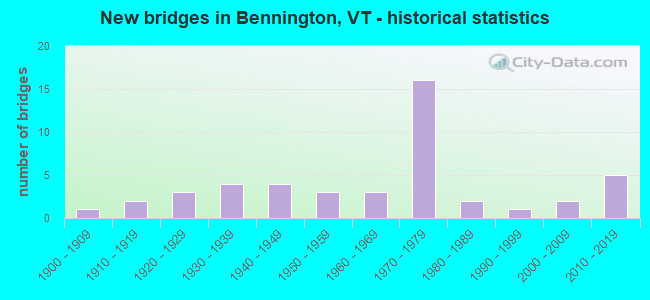
- New bridges - historical statistics
- 11900-1909
- 21910-1919
- 31920-1929
- 41930-1939
- 41940-1949
- 31950-1959
- 31960-1969
- 161970-1979
- 21980-1989
- 11990-1999
- 22000-2009
- 52010-2019

- Reconstructed bridges - Historical Statistics
- 11940-1949
- 01950-1959
- 01960-1969
- 11970-1979
- 21980-1989
- 41990-1999
- 12000-2009
- 12010-2019


- Bridge Condition - Deck
- 41.7%Very good
- 36.1%Good
- 19.4%Satisfactory
- 2.8%Fair

- Bridge Condition - Superstructure
- 52.8%Very good
- 16.7%Good
- 16.7%Satisfactory
- 13.9%Fair

- Bridge Condition - Substructure
- 22.2%Very good
- 58.3%Good
- 16.7%Satisfactory
- 2.8%Fair

- Bridge Condition - Channel
- 50.0%Very good
- 30.0%Good
- 16.7%Satisfactory
- 3.3%Fair

- Bridge Condition - Culverts
- 66.7%Very good
- 33.3%Satisfactory
Find on map >> Show street view
Structure Number: 200012000302022, Location: 0.3 MI N JCT VT 67A (Lat: 42.906667, Lng: -73.211667), Route carried "under" structure: Alternate State highway 7A, Year Built: 1973, Structure Length: 0. m, Average Daily Traffic: 4,800 (year 1998), Truck Traffic: 11%, Features Intersected: VT 279 OVER VT 7A, Facility Carried by Structure: VT 00279 ML
Minimum Vertical Clearance: 7.39m (24.25ft), Kilometerpoint: 0.000, Lanes on structure: 4, Material/Design: Steel continuous, Design/Construction: Stringer/Multi-beam, Length of Maximum Span: 26.5m (86.9ft)
Find on map >> Show street view
Structure Number: 20001203-102022, Location: 0.3 MI N JCT VT 67A (Lat: 42.906667, Lng: -73.211667), Route carried "under" structure: Alternate State highway 7A, Year Built: 1973, Structure Length: 0. m, Average Daily Traffic: 4,800 (year 1998), Truck Traffic: 11%, Features Intersected: VT 279 OVER VT 7A, Facility Carried by Structure: VT 00279 ML
Minimum Vertical Clearance: 7.24m (23.75ft), Kilometerpoint: 0.000, Lanes on structure: 4, Material/Design: Steel continuous, Design/Construction: Stringer/Multi-beam, Length of Maximum Span: 26.5m (86.9ft)
Find on map >> Show street view
Structure Number: 200019014A02022, Location: 1.0 MI N JCT VT 7A @ EX 1 (Lat: 42.905731, Lng: -73.207861), Route carried "under" structure: State highway 279, Year Built: 1973, Structure Length: 0. m, Average Daily Traffic: 2,400 (year 1998), Truck Traffic: 6%, Features Intersected: US 7 RAMP A OVER VT 279, Facility Carried by Structure: US 00007 RAMP
Minimum Vertical Clearance: 5.79m (19.00ft), Kilometerpoint: 1.496, Lanes on structure: 2, Material/Design: Steel continuous, Design/Construction: Stringer/Multi-beam, Length of Maximum Span: 36.3m (119.1ft)
Find on map >> Show street view
Structure Number: 200019014S02022, Location: 1.0 MI N JCT VT 7A @ EX 1 (Lat: 42.905700, Lng: -73.208236), Route carried "under" structure: State highway 279, Year Built: 1973, Structure Length: 0. m, Average Daily Traffic: 2,400 (year 1998), Truck Traffic: 6%, Features Intersected: US 7 S.B. OVER VT 279, Facility Carried by Structure: US 00007 ML
Minimum Vertical Clearance: 6.83m (22.41ft), Kilometerpoint: 1.496, Lanes on structure: 2, Material/Design: Steel continuous, Design/Construction: Stringer/Multi-beam, Length of Maximum Span: 36.3m (119.1ft)
Find on map >> Show street view
Structure Number: 200110011D02022, Location: 0.5 MI E JCT. US 7 (Lat: 42.901681, Lng: -73.191083), Route carried "under" structure: State highway 279, Year Built: 2009, Structure Length: 0. m, Average Daily Traffic: 4,550 (year 2010), Truck Traffic: 6%, Features Intersected: FAS 1021 OVER VT 279, Facility Carried by Structure: TH 5/FAS 1021
Minimum Vertical Clearance: 5.63m (18.47ft), Kilometerpoint: 2.300, Lanes on structure: 2, Material/Design: Steel continuous, Design/Construction: Stringer/Multi-beam, Length of Maximum Span: 39.0m (128.0ft)
Find on map >> Show street view
Structure Number: 200719013N02022, Location: 0.5 MI N JCT VT 7A (Lat: 42.902267, Lng: -73.199561), Route carried "under" structure: State highway 279, Year Built: 1973, Structure Length: 0. m, Average Daily Traffic: 13,400 (year 1998), Truck Traffic: 10%, Features Intersected: US 7 RAMP OVER VT 279, Facility Carried by Structure: US 00007 RAMP
Minimum Vertical Clearance: 5.18m (16.99ft), Kilometerpoint: 20.415, Lanes on structure: 2, Material/Design: Steel continuous, Design/Construction: Stringer/Multi-beam, Length of Maximum Span: 30.5m (100.1ft)
Find on map >> Show street view
Structure Number: 201000002A02022, Location: 0.2 MI N JCT. VT.67A (Lat: 42.904331, Lng: -73.211806), Route carried "under" structure: Alternate State highway 7A, Year Built: 1914, Structure Length: 0. m, Average Daily Traffic: 4,800 (year 1998), Truck Traffic: 2%, Features Intersected: VT RR OVER VT 7A, Facility Carried by Structure: RAILROAD
Kilometerpoint: 0.000, Material/Design: Steel, Design/Construction: Girder and Floorbeam System, Length of Maximum Span: 10.1m (33.1ft)