Bridge Statistics for Benton, Arkansas (AR)
Condition, Traffic, Stress, Structural Evaluation, Project Costs
- New bridges - historical statistics
- 31920-1929
- 21930-1939
- 11940-1949
- 131950-1959
- 11960-1969
- 21970-1979
- 41980-1989
- 71990-1999
- 142000-2009
- 42010-2019
- 32020-2022
- Reconstructed bridges - Historical Statistics
- 71970-1979
- 01980-1989
- 01990-1999
- 02000-2009
- 12010-2019
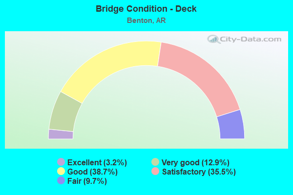
- Bridge Condition - Deck
- 3.2%Excellent
- 12.9%Very good
- 38.7%Good
- 35.5%Satisfactory
- 9.7%Fair
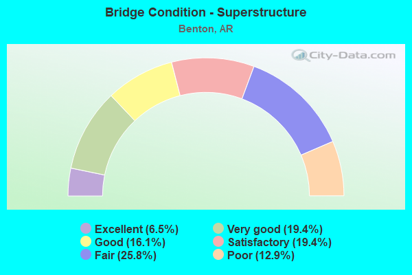
- Bridge Condition - Superstructure
- 6.5%Excellent
- 19.4%Very good
- 16.1%Good
- 19.4%Satisfactory
- 25.8%Fair
- 12.9%Poor
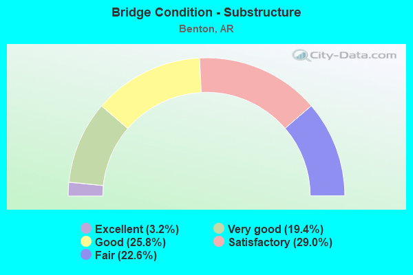
- Bridge Condition - Substructure
- 3.2%Excellent
- 19.4%Very good
- 25.8%Good
- 29.0%Satisfactory
- 22.6%Fair
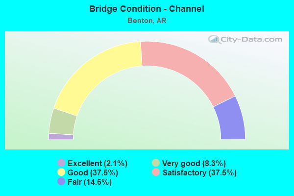
- Bridge Condition - Channel
- 2.1%Excellent
- 8.3%Very good
- 37.5%Good
- 37.5%Satisfactory
- 14.6%Fair
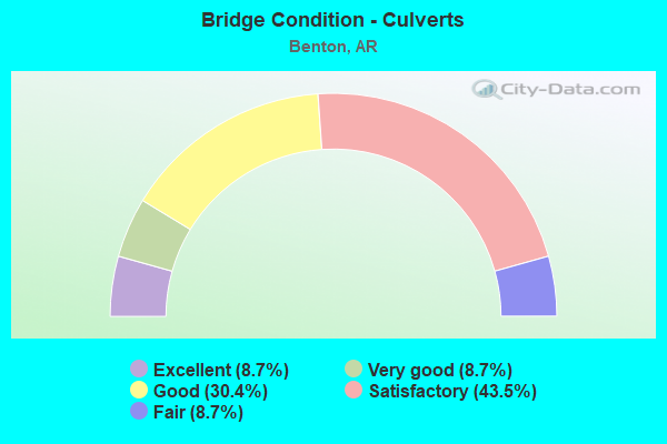
- Bridge Condition - Culverts
- 8.7%Excellent
- 8.7%Very good
- 30.4%Good
- 43.5%Satisfactory
- 8.7%Fair
Find on map >> Show street view
Structure Number: M0122, Location: 0.89 MI NO.WEST OF I-30 (Lat: 34.607311, Lng: -92.541150), Route carried "on" structure: State highway 5, Year Built: 1920, Status: Open, Structure Length: 0.70m (2.30ft), Average Daily Traffic: 9,000 (year 2018), Truck Traffic: 1%, Average Future Daily Traffic: 7,697 (year 2028), Design Load: H 15, Features Intersected: CREEK
Minimum Vertical Clearance: 30+ m (98+ ft), Kilometerpoint: 1.883, Lanes on structure: 2, Owner: State Highway Agency, Approaching Roadway Width: 9.1m (29.9ft), Skew: 4 degrees, Material/Design: Concrete, Design/Construction: Tee Beam, Number Of Spans In Main Unit: 1, Length of Maximum Span: 6.4m (21.0ft), Curb-To-Curb Width: 8.5m (27.9ft), Out-to-Out Width: 12.0m (39.4ft)
Condition: Deck: Satisfactory, Superstructure: Fair, Substructure: Fair, Channel: Satisfactory, Operating Rating: 39.0 metric tons, Method Used To Determine Operating Rating: Load Factor (LF), Inventory Rating: 23.6 metric tons, Method Used To Determine Inventory Rating: Load Factor (LF), Structural Evaluation: Somewhat better than minimum adequacy, Deck Geometry: High priority of replacement, Waterway Adequacy: Equal to present minimum criteria, Approach Roadway Alignment: Equal to present desirable criteria, Designated Inspection Frequency: Every 24 months, Critical Feature Inspection Frequency: Every 24 months, Inspection Date: July 2021, Deck Structure Type: Concrete Cast-file-Place, Wearing Surface/Protective System: Wearing Surface: Bituminous
Find on map >> Show street view
Structure Number: M0787, Location: 2.0 MI S OF SH 183 (Lat: 34.534569, Lng: -92.553550), Route carried "on" structure: State highway 35, Year Built: 1956, Status: Open, Structure Length: 0.67m (2.20ft), Average Daily Traffic: 5,400 (year 2018), Truck Traffic: 5%, Average Future Daily Traffic: 5,635 (year 2028), Design Load: H 15, Features Intersected: CREEK
Minimum Vertical Clearance: 30+ m (98+ ft), Kilometerpoint: 7.162, Lanes on structure: 2, Base Highway Network: Yes (Inventory Route: 350, Subroute: 35), Owner: State Highway Agency, Approaching Roadway Width: 8.5m (27.9ft), Material/Design: Concrete, Design/Construction: Culvert, Number Of Spans In Main Unit: 2, Length of Maximum Span: 3.0m (9.8ft)
Condition: Channel: Fair, Culverts: Satisfactory, Operating Rating: 35.4 metric tons, Method Used To Determine Operating Rating: Load Factor (LF), Inventory Rating: 21.8 metric tons, Method Used To Determine Inventory Rating: Load Factor (LF), Structural Evaluation: Somewhat better than minimum adequacy, Waterway Adequacy: Equal to present desirable criteria, Approach Roadway Alignment: Equal to present desirable criteria, Designated Inspection Frequency: Every 24 months, Critical Feature Inspection Frequency: Every 24 months, Inspection Date: March 2022
Find on map >> Show street view
Structure Number: M2245, Location: 0.42 MI E JCT SH 35 & 183 (Lat: 34.556850, Lng: -92.562211), Route carried "on" structure: State highway 183, Year Built: 1934, Status: Open, Structure Length: 0.73m (2.40ft), Average Daily Traffic: 8,000 (year 2018), Truck Traffic: 1%, Average Future Daily Traffic: 9,071 (year 2028), Features Intersected: LICKH CREEK
Minimum Vertical Clearance: 30+ m (98+ ft), Kilometerpoint: 0.418, Lanes on structure: 2, Owner: State Highway Agency, Approaching Roadway Width: 11.0m (36.1ft), Skew: 3 degrees, Material/Design: Concrete, Design/Construction: Culvert, Number Of Spans In Main Unit: 2, Length of Maximum Span: 3.7m (12.1ft)
Condition: Channel: Satisfactory, Culverts: Satisfactory, Operating Rating: 39.9 metric tons, Method Used To Determine Operating Rating: Load Factor (LF), Inventory Rating: 23.6 metric tons, Method Used To Determine Inventory Rating: Load Factor (LF), Structural Evaluation: Somewhat better than minimum adequacy, Waterway Adequacy: Equal to present desirable criteria, Approach Roadway Alignment: Equal to present desirable criteria, Designated Inspection Frequency: Every 24 months, Critical Feature Inspection Frequency: Every 24 months, Inspection Date: March 2022
Find on map >> Show street view
Structure Number: M3031, Location: 3.0 MI SW JCT SH 5 & I 30 (Lat: 34.545650, Lng: -92.631058), Route carried "on" structure: Interstate 30, Year Built: 1958, Status: Open, Structure Length: 0.70m (2.30ft), Average Daily Traffic: 687 (year 2014), Truck Traffic: 30%, Average Future Daily Traffic: 74,000 (year 2033), Features Intersected: DITCH
Minimum Vertical Clearance: 30+ m (98+ ft), Kilometerpoint: 183.031, Lanes on structure: 9, Base Highway Network: Yes (Inventory Route: 302, Subroute: 10), Owner: State Highway Agency, Approaching Roadway Width: 30.2m (99.1ft), Skew: 11 degrees, Material/Design: Concrete, Design/Construction: Culvert, Number Of Spans In Main Unit: 2, Length of Maximum Span: 3.4m (11.2ft)
Condition: Channel: Satisfactory, Culverts: Satisfactory, Operating Rating: 39.9 metric tons, Method Used To Determine Operating Rating: Load Factor (LF), Inventory Rating: 23.6 metric tons, Method Used To Determine Inventory Rating: Load Factor (LF), Structural Evaluation: Equal to present minimum criteria, Waterway Adequacy: Equal to present desirable criteria, Approach Roadway Alignment: Equal to present desirable criteria, Designated Inspection Frequency: Every 24 months, Critical Feature Inspection Frequency: Every 24 months, Inspection Date: June 2020
Find on map >> Show street view
Structure Number: M3032, Location: 0.5 MI SW OF SH 5 AT BETN (Lat: 34.567969, Lng: -92.598219), Route carried "on" structure: Interstate 30, Year Built: 1952, Status: Open, Structure Length: 1.19m (3.90ft), Average Daily Traffic: 68,000 (year 2018), Truck Traffic: 21%, Average Future Daily Traffic: 87,966 (year 2028), Design Load: HS 20+Mod, Features Intersected: McNEIL CREEK
Minimum Vertical Clearance: 30+ m (98+ ft), Kilometerpoint: 186.958, Lanes on structure: 7, Base Highway Network: Yes (Inventory Route: 302, Subroute: 30), Owner: State Highway Agency, Approaching Roadway Width: 47.5m (155.8ft), Skew: 33 degrees, Material/Design: Concrete continuous, Design/Construction: Culvert, Number Of Spans In Main Unit: 3, Length of Maximum Span: 4.0m (13.1ft)
Condition: Channel: Satisfactory, Culverts: Satisfactory, Operating Rating: 54.4 metric tons, Method Used To Determine Operating Rating: Load Factor (LF), Inventory Rating: 32.7 metric tons, Method Used To Determine Inventory Rating: Load Factor (LF), Structural Evaluation: Equal to present minimum criteria, Waterway Adequacy: Equal to present desirable criteria, Approach Roadway Alignment: Equal to present desirable criteria, Designated Inspection Frequency: Every 24 months, Critical Feature Inspection Frequency: Every 24 months, Inspection Date: April 2020, Deck Structure Type: Concrete Cast-file-Place, Wearing Surface/Protective System: Wearing Surface: Monolithic Concrete
Find on map >> Show street view
Structure Number: X0121, Location: I-30 Log 117.57 (Lat: 34.580350, Lng: -92.579269), Route carried "on" structure: Interstate 30, Year Built: 1952, Status: Open, Structure Length: 0.94m (3.08ft), Average Daily Traffic: 71,872 (year 2018), Truck Traffic: 21%, Average Future Daily Traffic: 91,900 (year 2038), Design Load: H 20, Features Intersected: McNEIL CREEK
Minimum Vertical Clearance: 30+ m (98+ ft), Kilometerpoint: 189.211, Lanes on structure: 10, Base Highway Network: Yes (Inventory Route: 302, Subroute: 30), Owner: State Highway Agency, Approaching Roadway Width: 61.9m (203.1ft), Skew: 14 degrees, Material/Design: Concrete, Design/Construction: Culvert, Number Of Spans In Main Unit: 2, Length of Maximum Span: 4.3m (14.1ft)
Condition: Channel: Satisfactory, Culverts: Fair, Operating Rating: 39.9 metric tons, Method Used To Determine Operating Rating: Load Factor (LF), Inventory Rating: 23.6 metric tons, Method Used To Determine Inventory Rating: Load Factor (LF), Structural Evaluation: Somewhat better than minimum adequacy, Waterway Adequacy: Equal to present desirable criteria, Approach Roadway Alignment: Equal to present desirable criteria, Designated Inspection Frequency: Every 24 months, Critical Feature Inspection Frequency: Every 24 months, Inspection Date: April 2020
Find on map >> Show street view
Structure Number: X0209, Location: SH 5 & 35 INTERCHANGE (Lat: 34.571650, Lng: -92.591261), Route carried "on" structure: Ramp Interstate 30, Year Built: 1958, Status: Open, Structure Length: 1.01m (3.31ft), Average Daily Traffic: 7,308 (year 2011), Truck Traffic: 1%, Average Future Daily Traffic: 2,750 (year 2028), Design Load: H 20, Features Intersected: McNEIL CREEK
Minimum Vertical Clearance: 30+ m (98+ ft), Kilometerpoint: 187.714, Lanes on structure: 2, Owner: State Highway Agency, Approaching Roadway Width: 10.7m (35.1ft), Material/Design: Concrete, Design/Construction: Culvert, Number Of Spans In Main Unit: 3, Length of Maximum Span: 3.0m (9.8ft)
Condition: Channel: Good, Culverts: Satisfactory, Operating Rating: 39.0 metric tons, Method Used To Determine Operating Rating: Load Factor (LF), Inventory Rating: 23.6 metric tons, Method Used To Determine Inventory Rating: Load Factor (LF), Structural Evaluation: Somewhat better than minimum adequacy, Waterway Adequacy: Equal to present desirable criteria, Approach Roadway Alignment: Equal to present desirable criteria, Designated Inspection Frequency: Every 24 months, Critical Feature Inspection Frequency: Every 24 months, Inspection Date: May 2020
Find on map >> Show street view
Structure Number: X068, Location: 3.1 MI N SH 35&I-30 JCT (Lat: 34.604469, Lng: -92.616881), Route carried "on" structure: State highway 5, Year Built: 1987, Status: Open, Structure Length: 1.05m (3.44ft), Average Daily Traffic: 6,200 (year 2018), Truck Traffic: 1%, Average Future Daily Traffic: 7,010 (year 2028), Design Load: H 20, Features Intersected: SALINE RIV RELIEF
Minimum Vertical Clearance: 30+ m (98+ ft), Kilometerpoint: 25.733, Lanes on structure: 2, Base Highway Network: Yes, Owner: State Highway Agency, Approaching Roadway Width: 13.4m (44.0ft), Material/Design: Concrete, Design/Construction: Culvert, Number Of Spans In Main Unit: 4, Length of Maximum Span: 2.4m (7.9ft)
Condition: Channel: Fair, Culverts: Satisfactory, Operating Rating: 53.5 metric tons, Method Used To Determine Operating Rating: Load Factor (LF), Inventory Rating: 31.8 metric tons, Method Used To Determine Inventory Rating: Load Factor (LF), Structural Evaluation: Equal to present minimum criteria, Waterway Adequacy: Equal to present desirable criteria, Approach Roadway Alignment: Equal to present desirable criteria, Designated Inspection Frequency: Every 24 months, Critical Feature Inspection Frequency: Every 24 months, Inspection Date: December 2021
Find on map >> Show street view
Structure Number: X1044, Location: 2.5 MI SW OF BENTON (Lat: 34.536700, Lng: -92.642539), Route carried "on" structure: US 67, Year Built: 2001, Status: Open, Structure Length: 0.89m (2.92ft), Average Daily Traffic: 14,000 (year 2018), Truck Traffic: 3%, Average Future Daily Traffic: 16,494 (year 2028), Design Load: H 20, Features Intersected: DOBBS CREEK
Minimum Vertical Clearance: 30+ m (98+ ft), Kilometerpoint: 10.652, Lanes on structure: 2, Owner: State Highway Agency, Approaching Roadway Width: 12.2m (40.0ft), Material/Design: Concrete, Design/Construction: Culvert, Number Of Spans In Main Unit: 2, Length of Maximum Span: 3.7m (12.1ft)
Condition: Channel: Good, Culverts: Good, Operating Rating: 31.8 metric tons, Method Used To Determine Operating Rating: Load Factor (LF), Inventory Rating: 19.1 metric tons, Method Used To Determine Inventory Rating: Load Factor (LF), Structural Evaluation: Meets minimum limits, Waterway Adequacy: Equal to present desirable criteria, Approach Roadway Alignment: Equal to present desirable criteria, Designated Inspection Frequency: Every 24 months, Critical Feature Inspection Frequency: Every 24 months, Inspection Date: November 2021
Find on map >> Show street view
Structure Number: X1068, Location: 0.4 MI S SH 5 (Lat: 34.572369, Lng: -92.590481), Route carried "on" structure: State highway 35, Year Built: 2004, Status: Open, Structure Length: 1.07m (3.51ft), Average Daily Traffic: 20,410 (year 2018), Truck Traffic: 1%, Average Future Daily Traffic: 20,617 (year 2028), Design Load: H 20, Features Intersected: McNEIL CREEK
Minimum Vertical Clearance: 30.17m (98.98ft), Kilometerpoint: 0.531, Lanes on structure: 5, Base Highway Network: Yes (Inventory Route: 350, Subroute: 35), Owner: State Highway Agency, Approaching Roadway Width: 22.6m (74.1ft), Material/Design: Concrete, Design/Construction: Culvert, Number Of Spans In Main Unit: 3, Length of Maximum Span: 3.4m (11.2ft)
Condition: Channel: Good, Culverts: Satisfactory, Operating Rating: 39.9 metric tons, Method Used To Determine Operating Rating: Load Factor (LF), Inventory Rating: 23.6 metric tons, Method Used To Determine Inventory Rating: Load Factor (LF), Structural Evaluation: Somewhat better than minimum adequacy, Waterway Adequacy: Equal to present desirable criteria, Approach Roadway Alignment: Equal to present desirable criteria, Designated Inspection Frequency: Every 24 months, Critical Feature Inspection Frequency: Every 24 months, Inspection Date: May 2020
Find on map >> Show street view
Structure Number: X1246, Location: 15.3 Mi E Garland Co Line (Lat: 34.607661, Lng: -92.632169), Route carried "on" structure: State highway 5, Year Built: 2005, Status: Open, Structure Length: 0.91m (2.99ft), Average Daily Traffic: 4,200 (year 2018), Truck Traffic: 4%, Average Future Daily Traffic: 4,261 (year 2028), Design Load: H 20, Features Intersected: MOCCASIN CREEK
Minimum Vertical Clearance: 30+ m (98+ ft), Kilometerpoint: 24.382, Lanes on structure: 2, Owner: State Highway Agency, Approaching Roadway Width: 12.2m (40.0ft), Skew: 2 degrees, Material/Design: Concrete, Design/Construction: Culvert, Number Of Spans In Main Unit: 3, Length of Maximum Span: 2.9m (9.5ft)
Condition: Channel: Good, Culverts: Satisfactory, Operating Rating: 38.1 metric tons, Method Used To Determine Operating Rating: Load Factor (LF), Inventory Rating: 22.7 metric tons, Method Used To Determine Inventory Rating: Load Factor (LF), Structural Evaluation: Equal to present minimum criteria, Waterway Adequacy: Equal to present desirable criteria, Approach Roadway Alignment: Equal to present desirable criteria, Designated Inspection Frequency: Every 24 months, Critical Feature Inspection Frequency: Every 24 months, Inspection Date: December 2021
Find on map >> Show street view
Structure Number: X1249, Location: 350' E Jct Edison & East (Lat: 34.557589, Lng: -92.584358), Route carried "on" structure: State highway 35, Year Built: 2009, Status: Open, Structure Length: 0.68m (2.23ft), Average Daily Traffic: 15,000 (year 2018), Truck Traffic: 1%, Average Future Daily Traffic: 16,494 (year 2028), Design Load: H 20, Features Intersected: DEPOT CREEK
Minimum Vertical Clearance: 30+ m (98+ ft), Kilometerpoint: 2.591, Lanes on structure: 3, Base Highway Network: Yes, Owner: State Highway Agency, Approaching Roadway Width: 11.6m (38.1ft), Material/Design: Concrete, Design/Construction: Culvert, Number Of Spans In Main Unit: 2, Length of Maximum Span: 3.0m (9.8ft), Curb or Sidewalk Widths: Left: 0.2m (0.7ft), Right: 0.2m (0.7ft)
Condition: Channel: Good, Culverts: Good, Operating Rating: 30.8 metric tons, Method Used To Determine Operating Rating: Load Factor (LF), Inventory Rating: 18.1 metric tons, Method Used To Determine Inventory Rating: Load Factor (LF), Structural Evaluation: Meets minimum limits, Waterway Adequacy: Equal to present desirable criteria, Approach Roadway Alignment: Equal to present desirable criteria, Designated Inspection Frequency: Every 24 months, Critical Feature Inspection Frequency: Every 24 months, Inspection Date: January 2021, Deck Structure Type: Concrete Cast-file-Place, Wearing Surface/Protective System: Wearing Surface: Bituminous
Find on map >> Show street view
Structure Number: X1606, Location: 0.12M W of JCT Hwy 229 (Lat: 34.546775, Lng: -92.632517), Route carried "on" structure: Ramp Interstate 30, Year Built: 2021, Status: Open, Structure Length: 0.94m (3.08ft), Average Daily Traffic: 700 (year 2020), Average Future Daily Traffic: 840 (year 2040), Features Intersected: Ditch
Minimum Vertical Clearance: 30+ m (98+ ft), Kilometerpoint: 182.773, Lanes on structure: 2, Base Highway Network: Yes (Inventory Route: 302, Subroute: 10), Owner: State Highway Agency, Approaching Roadway Width: 12.2m (40.0ft), Material/Design: Concrete, Design/Construction: Culvert, Number Of Spans In Main Unit: 3, Length of Maximum Span: 3.0m (9.8ft)
Condition: Channel: Very good, Culverts: Excellent, Operating Rating: 54.4 metric tons, Method Used To Determine Operating Rating: Load and Resistance Factor (LRFR), Inventory Rating: 32.7 metric tons, Method Used To Determine Inventory Rating: Load and Resistance Factor (LRFR), Structural Evaluation: Superior to present desirable criteria, Waterway Adequacy: Equal to present desirable criteria, Approach Roadway Alignment: Equal to present desirable criteria, Designated Inspection Frequency: Every 24 months, Critical Feature Inspection Frequency: Every 24 months, Inspection Date: March 2021
Find on map >> Show street view
Structure Number: 3141, Location: 1.13 MI SW JCT SH 35 (Lat: 34.565169, Lng: -92.603319), Route carried "under" structure: ServiceInterstate 30, Structure Length: 0. m, Average Daily Traffic: 30,500 (year 2014), Truck Traffic: 5%, Features Intersected: I-30 Log 115.92, Facility Carried by Structure: SEVIER STREET
Minimum Vertical Clearance: 5.30m (17.39ft), Kilometerpoint: 186.394, Length of Maximum Span: 0.0m
Find on map >> Show street view
Structure Number: 3141, Location: 1.13 MI SW JCT SH 35 (Lat: 34.565169, Lng: -92.603319), Route carried "under" structure: Interstate 30, Structure Length: 0. m, Average Daily Traffic: 30,500 (year 2014), Truck Traffic: 30%, Features Intersected: I-30 Log 115.92, Facility Carried by Structure: SEVIER STREET
Minimum Vertical Clearance: 4.80m (15.75ft), Kilometerpoint: 186.394, Length of Maximum Span: 0.0m
Find on map >> Show street view
Structure Number: 3141, Location: 1.13 MI SW JCT SH 35 (Lat: 34.565169, Lng: -92.603319), Route carried "under" structure: Interstate 30, Structure Length: 0. m, Average Daily Traffic: 30,500 (year 2014), Truck Traffic: 30%, Features Intersected: I-30 Log 115.92, Facility Carried by Structure: SEVIER STREET
Minimum Vertical Clearance: 4.77m (15.65ft), Kilometerpoint: 186.394, Length of Maximum Span: 0.0m
Find on map >> Show street view
Structure Number: 3141, Location: 1.13 MI SW JCT SH 35 (Lat: 34.565169, Lng: -92.603319), Route carried "under" structure: ServiceInterstate 30, Structure Length: 0. m, Average Daily Traffic: 30,500 (year 2014), Truck Traffic: 5%, Features Intersected: I-30 Log 115.92, Facility Carried by Structure: SEVIER STREET
Minimum Vertical Clearance: 5.18m (16.99ft), Kilometerpoint: 186.394, Length of Maximum Span: 0.0m
Find on map >> Show street view
Structure Number: 4896, Location: 0.11 N SH 35 (Lat: 34.558808, Lng: -92.567086), Route carried "under" structure: City street 4510, Structure Length: 0. m, Average Daily Traffic: 200 (year 2010), Truck Traffic: 1%, Features Intersected: U.P.R.R & Benton Pkwy., Facility Carried by Structure: Benton Parkway
Minimum Vertical Clearance: 5.57m (18.27ft), Kilometerpoint: 0.274, Length of Maximum Span: 0.0m
Find on map >> Show street view
Structure Number: 659, Location: 0.1 MI SO OF SH 35 (Lat: 34.553967, Lng: -92.582253), Route carried "under" structure: City street 62620, Structure Length: 0. m, Average Daily Traffic: 250 (year 1998), Truck Traffic: 1%, Features Intersected: UPRR WILLOW ST DEPO CRK, Facility Carried by Structure: 2ND STREET BENTON
Minimum Vertical Clearance: 6.15m (20.18ft), Kilometerpoint: 0.016, Length of Maximum Span: 0.0m
Find on map >> Show street view
Structure Number: 6826, Location: 1.4 M. NO CONGO RD. (Lat: 34.597642, Lng: -92.554161), Route carried "under" structure: Interstate 30, Structure Length: 0. m, Average Daily Traffic: 34,500 (year 2014), Truck Traffic: 3%, Features Intersected: I-30 SEC 22 Log 128.01, Facility Carried by Structure: SH 5 / Military Rd
Minimum Vertical Clearance: 5.45m (17.88ft), Kilometerpoint: 192.156, Length of Maximum Span: 0.0m
Find on map >> Show street view
Structure Number: 6826, Location: 1.4 M. NO CONGO RD. (Lat: 34.597642, Lng: -92.554161), Route carried "under" structure: Interstate 30, Structure Length: 0. m, Average Daily Traffic: 34,500 (year 2014), Truck Traffic: 3%, Features Intersected: I-30 SEC 22 Log 128.01, Facility Carried by Structure: SH 5 / Military Rd
Minimum Vertical Clearance: 5.73m (18.80ft), Kilometerpoint: 192.156, Length of Maximum Span: 0.0m
Find on map >> Show street view
Structure Number: 6826, Location: 1.4 M. NO CONGO RD. (Lat: 34.597642, Lng: -92.554161), Route carried "under" structure: ServiceInterstate 30, Structure Length: 0. m, Average Daily Traffic: 34,500 (year 2014), Truck Traffic: 3%, Features Intersected: I-30 SEC 22 Log 128.01, Facility Carried by Structure: SH 5 / Military Rd
Minimum Vertical Clearance: 6.33m (20.77ft), Kilometerpoint: 192.156, Length of Maximum Span: 0.0m
Find on map >> Show street view
Structure Number: 6826, Location: 1.4 M. NO CONGO RD. (Lat: 34.597642, Lng: -92.554161), Route carried "under" structure: ServiceInterstate 30, Structure Length: 0. m, Average Daily Traffic: 34,500 (year 2014), Truck Traffic: 3%, Features Intersected: I-30 SEC 22 Log 128.01, Facility Carried by Structure: SH 5 / Military Rd
Minimum Vertical Clearance: 5.60m (18.37ft), Kilometerpoint: 192.156, Length of Maximum Span: 0.0m
Find on map >> Show street view
Structure Number: 6834, Location: I-30 Sec22 Log 120.66 (Lat: 34.605281, Lng: -92.534519), Route carried "under" structure: Interstate 30, Structure Length: 0. m, Average Daily Traffic: 38,000 (year 2014), Truck Traffic: 5%, Features Intersected: I-30 SEC 22 Log 120.66, Facility Carried by Structure: CR 25 (Alcoa Rd)
Minimum Vertical Clearance: 5.48m (17.98ft), Kilometerpoint: 194.184, Length of Maximum Span: 0.0m
Find on map >> Show street view
Structure Number: 6834, Location: I-30 Sec22 Log 120.66 (Lat: 34.605281, Lng: -92.534519), Route carried "under" structure: Interstate 30, Structure Length: 0. m, Average Daily Traffic: 38,000 (year 2014), Truck Traffic: 5%, Features Intersected: I-30 SEC 22 Log 120.66, Facility Carried by Structure: CR 25 (Alcoa Rd)
Minimum Vertical Clearance: 5.69m (18.67ft), Kilometerpoint: 194.184, Length of Maximum Span: 0.0m
Find on map >> Show street view
Structure Number: 6834, Location: I-30 Sec22 Log 120.66 (Lat: 34.605281, Lng: -92.534519), Route carried "under" structure: ServiceInterstate 30, Structure Length: 0. m, Average Daily Traffic: 38,000 (year 2014), Truck Traffic: 5%, Features Intersected: I-30 SEC 22 Log 120.66, Facility Carried by Structure: CR 25 (Alcoa Rd)
Minimum Vertical Clearance: 5.42m (17.78ft), Kilometerpoint: 194.184, Length of Maximum Span: 0.0m
Find on map >> Show street view
Structure Number: 6834, Location: I-30 Sec22 Log 120.66 (Lat: 34.605281, Lng: -92.534519), Route carried "under" structure: ServiceInterstate 30, Structure Length: 0. m, Average Daily Traffic: 38,000 (year 2014), Truck Traffic: 5%, Features Intersected: I-30 SEC 22 Log 120.66, Facility Carried by Structure: CR 25 (Alcoa Rd)
Minimum Vertical Clearance: 6.52m (21.39ft), Kilometerpoint: 194.184, Length of Maximum Span: 0.0m
Find on map >> Show street view
Structure Number: 6866, Location: .35 MI S Jct SH 5 (Lat: 34.573219, Lng: -92.591381), Route carried "under" structure: Interstate 30, Structure Length: 0. m, Average Daily Traffic: 32,500 (year 2014), Truck Traffic: 1%, Features Intersected: I-30 Log 116.69, Facility Carried by Structure: SH 35 Sec 1
Minimum Vertical Clearance: 5.33m (17.49ft), Kilometerpoint: 187.794, Length of Maximum Span: 0.0m
Find on map >> Show street view
Structure Number: 6866, Location: .35 MI S Jct SH 5 (Lat: 34.573219, Lng: -92.591381), Route carried "under" structure: Interstate 30, Structure Length: 0. m, Average Daily Traffic: 32,500 (year 2014), Truck Traffic: 1%, Features Intersected: I-30 Log 116.69, Facility Carried by Structure: SH 35 Sec 1
Minimum Vertical Clearance: 5.71m (18.73ft), Kilometerpoint: 187.794, Length of Maximum Span: 0.0m
Find on map >> Show street view
Structure Number: 6866, Location: .35 MI S Jct SH 5 (Lat: 34.573219, Lng: -92.591381), Route carried "under" structure: ServiceInterstate 30, Structure Length: 0. m, Average Daily Traffic: 32,500 (year 2014), Truck Traffic: 1%, Features Intersected: I-30 Log 116.69, Facility Carried by Structure: SH 35 Sec 1
Minimum Vertical Clearance: 5.57m (18.27ft), Kilometerpoint: 187.794, Length of Maximum Span: 0.0m
Find on map >> Show street view
Structure Number: 6866, Location: .35 MI S Jct SH 5 (Lat: 34.573219, Lng: -92.591381), Route carried "under" structure: ServiceInterstate 30, Structure Length: 0. m, Average Daily Traffic: 32,500 (year 2014), Truck Traffic: 1%, Features Intersected: I-30 Log 116.69, Facility Carried by Structure: SH 35 Sec 1
Minimum Vertical Clearance: 5.05m (16.57ft), Kilometerpoint: 187.794, Length of Maximum Span: 0.0m
Find on map >> Show street view
Structure Number: 6867, Location: 1.63 M NE SH 35 (Lat: 34.586539, Lng: -92.568189), Route carried "under" structure: ServiceInterstate 30, Structure Length: 0. m, Average Daily Traffic: 34,500 (year 2014), Truck Traffic: 3%, Features Intersected: I-30 SEC 22 Log 118.31, Facility Carried by Structure: Congo Road
Minimum Vertical Clearance: 6.40m (21.00ft), Kilometerpoint: 190.402, Length of Maximum Span: 0.0m
Find on map >> Show street view
Structure Number: 6867, Location: 1.63 M NE SH 35 (Lat: 34.586539, Lng: -92.568189), Route carried "under" structure: Interstate 30, Structure Length: 0. m, Average Daily Traffic: 34,500 (year 2014), Truck Traffic: 3%, Features Intersected: I-30 SEC 22 Log 118.31, Facility Carried by Structure: Congo Road
Minimum Vertical Clearance: 5.46m (17.91ft), Kilometerpoint: 190.402, Length of Maximum Span: 0.0m
Find on map >> Show street view
Structure Number: 6867, Location: 1.63 M NE SH 35 (Lat: 34.586539, Lng: -92.568189), Route carried "under" structure: ServiceInterstate 30, Structure Length: 0. m, Average Daily Traffic: 34,500 (year 2014), Truck Traffic: 3%, Features Intersected: I-30 SEC 22 Log 118.31, Facility Carried by Structure: Congo Road
Minimum Vertical Clearance: 5.23m (17.16ft), Kilometerpoint: 190.402, Length of Maximum Span: 0.0m
Find on map >> Show street view
Structure Number: 6867, Location: 1.63 M NE SH 35 (Lat: 34.586539, Lng: -92.568189), Route carried "under" structure: Interstate 30, Structure Length: 0. m, Average Daily Traffic: 34,500 (year 2014), Truck Traffic: 3%, Features Intersected: I-30 SEC 22 Log 118.31, Facility Carried by Structure: Congo Road
Minimum Vertical Clearance: 5.61m (18.41ft), Kilometerpoint: 190.402, Length of Maximum Span: 0.0m
Find on map >> Show street view
Structure Number: A3092, Location: 3 MI SW SH 5 BENTON (Lat: 34.544711, Lng: -92.631381), Route carried "under" structure: US 67, Structure Length: 0. m, Average Daily Traffic: 13,000 (year 2014), Truck Traffic: 1%, Features Intersected: US 67-9 Log 7.61, Facility Carried by Structure: I -30 Log 113.64
Minimum Vertical Clearance: 5.12m (16.80ft), Kilometerpoint: 12.262, Length of Maximum Span: 0.0m
Find on map >> Show street view
Structure Number: A3094, Location: 2.6 MI SW SH 5 AT BENTON (Lat: 34.552061, Lng: -92.622261), Route carried "under" structure: City street 25790, Structure Length: 0. m, Average Daily Traffic: 50 (year 0000), Features Intersected: Henry street, Facility Carried by Structure: I-30 EB Log 114.38
Minimum Vertical Clearance: 5.10m (16.73ft), Kilometerpoint: 0.805, Length of Maximum Span: 0.0m
Find on map >> Show street view
Structure Number: B3092, Location: 3.0 MI SW SH 5 @ BENTON (Lat: 34.544969, Lng: -92.631289), Route carried "under" structure: US 67, Structure Length: 0. m, Average Daily Traffic: 13,000 (year 2014), Truck Traffic: 1%, Features Intersected: US 67-9 Log 7.61, Facility Carried by Structure: I -30-SEC 22 WB
Minimum Vertical Clearance: 4.38m (14.37ft), Kilometerpoint: 12.244, Length of Maximum Span: 0.0m
Find on map >> Show street view
Structure Number: B3094, Location: 2.6 MI SW OF SH 5 @ BENTO (Lat: 34.552311, Lng: -92.622281), Route carried "under" structure: City street 25790, Structure Length: 0. m, Average Daily Traffic: 50 (year 0000), Features Intersected: Henry Street, Facility Carried by Structure: I-30 WB Log 114.38
Minimum Vertical Clearance: 4.87m (15.98ft), Kilometerpoint: 0.821, Length of Maximum Span: 0.0m