Bridge Statistics for Bentonville, Arkansas (AR)
Condition, Traffic, Stress, Structural Evaluation, Project Costs
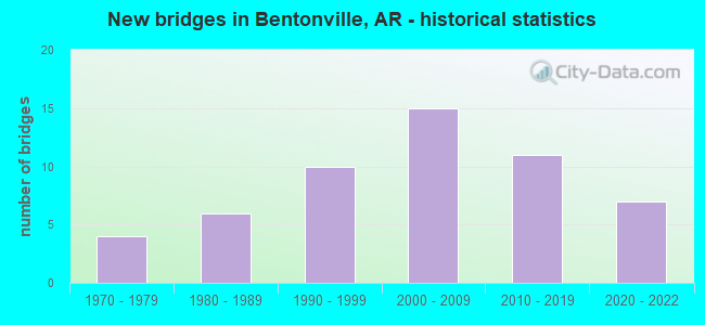
- New bridges - historical statistics
- 41970-1979
- 61980-1989
- 101990-1999
- 152000-2009
- 112010-2019
- 72020-2022


- Bridge Condition - Deck
- 3.6%Excellent
- 25.0%Very good
- 57.1%Good
- 14.3%Satisfactory

- Bridge Condition - Superstructure
- 14.3%Excellent
- 17.9%Very good
- 35.7%Good
- 25.0%Satisfactory
- 7.1%Fair

- Bridge Condition - Substructure
- 7.1%Excellent
- 42.9%Very good
- 17.9%Good
- 21.4%Satisfactory
- 10.7%Fair

- Bridge Condition - Channel
- 4.5%Excellent
- 40.9%Very good
- 18.2%Good
- 20.5%Satisfactory
- 15.9%Fair

- Bridge Condition - Culverts
- 4.0%Excellent
- 16.0%Very good
- 40.0%Good
- 40.0%Satisfactory
Find on map >> Show street view
Structure Number: B5984, Location: 2.26 MI N SH 72 (Lat: 36.404450, Lng: -94.197919), Route carried "on" structure: Interstate 49, Year Built: 1989, Status: Open, Structure Length: 4.69m (15.39ft), Average Daily Traffic: 19,500 (year 2018), Truck Traffic: 1%, Average Future Daily Traffic: 21,860 (year 2028), Design Load: HS 20, Features Intersected: CO RD 831-G
Minimum Vertical Clearance: 30+ m (98+ ft), Kilometerpoint: 145.018, Lanes on structure: 2, Lanes under structure: 2, Base Highway Network: Yes, Owner: State Highway Agency, Approaching Roadway Width: 12.2m (40.0ft), Skew: 3 degrees, Material/Design: Steel continuous, Design/Construction: Stringer/Multi-beam, Number Of Spans In Main Unit: 3, Length of Maximum Span: 19.5m (64.0ft), Curb-To-Curb Width: 12.2m (40.0ft), Out-to-Out Width: 13.0m (42.7ft)
Condition: Deck: Good, Superstructure: Satisfactory, Substructure: Good, Operating Rating: 54.4 metric tons, Method Used To Determine Operating Rating: Load Factor (LF), Inventory Rating: 32.7 metric tons, Method Used To Determine Inventory Rating: Load Factor (LF), Structural Evaluation: Equal to present minimum criteria, Deck Geometry: Better than present minimum criteria, Underclear: Somewhat better than minimum adequacy, Approach Roadway Alignment: Equal to present desirable criteria, Designated Inspection Frequency: Every 24 months, Critical Feature Inspection Frequency: Every 24 months, Inspection Date: October 2021, Deck Structure Type: Concrete Cast-file-Place, Wearing Surface/Protective System: Wearing Surface: Monolithic Concrete, Deck Protection: Epoxy Coated Reinforcing
Find on map >> Show street view
Structure Number: X0601, Location: .15 MI N JCT 102 & 71 (Lat: 36.358100, Lng: -94.214228), Route carried "on" structure: Business US 71, Year Built: 1985, Status: Open, Structure Length: 0.79m (2.59ft), Average Daily Traffic: 26,597 (year 2018), Truck Traffic: 1%, Average Future Daily Traffic: 46,258 (year 2027), Design Load: H 20, Features Intersected: DITCH
Minimum Vertical Clearance: 30+ m (98+ ft), Kilometerpoint: 4.987, Lanes on structure: 5, Owner: State Highway Agency, Approaching Roadway Width: 20.4m (66.9ft), Skew: 3 degrees, Material/Design: Concrete, Design/Construction: Culvert, Number Of Spans In Main Unit: 6, Length of Maximum Span: 2.1m (6.9ft)
Condition: Channel: Very good, Culverts: Good, Operating Rating: 26.3 metric tons, Method Used To Determine Operating Rating: Load Factor (LF), Inventory Rating: 15.4 metric tons, Method Used To Determine Inventory Rating: Load Factor (LF), Structural Evaluation: High priority of corrective action, Waterway Adequacy: Equal to present desirable criteria, Approach Roadway Alignment: Equal to present desirable criteria, Designated Inspection Frequency: Every 48 months, Critical Feature Inspection Frequency: Every 24 months, Inspection Date: April 2018
Find on map >> Show street view
Structure Number: X0773, Location: 2.94 MI N SH 71 (Lat: 36.413056, Lng: -94.219722), Route carried "on" structure: State highway 49, Year Built: 1990, Status: Open, Structure Length: 3.29m (10.79ft), Average Daily Traffic: 18,579 (year 2018), Truck Traffic: 2%, Average Future Daily Traffic: 28,347 (year 2027), Design Load: HS 15, Features Intersected: CREEK
Minimum Vertical Clearance: 0.00m, Kilometerpoint: 11.426, Lanes on structure: 4, Base Highway Network: Yes, Owner: State Highway Agency, Approaching Roadway Width: 22.3m (73.2ft), Skew: 3 degrees, Material/Design: Concrete, Design/Construction: Culvert, Number Of Spans In Main Unit: 6, Length of Maximum Span: 5.5m (18.0ft)
Condition: Channel: Good, Culverts: Satisfactory, Operating Rating: 33.6 metric tons, Method Used To Determine Operating Rating: Load Factor (LF), Inventory Rating: 20.0 metric tons, Method Used To Determine Inventory Rating: Load Factor (LF), Structural Evaluation: Somewhat better than minimum adequacy, Waterway Adequacy: Equal to present minimum criteria, Approach Roadway Alignment: Equal to present desirable criteria, Designated Inspection Frequency: Every 24 months, Critical Feature Inspection Frequency: Every 24 months, Inspection Date: June 2020
Find on map >> Show street view
Structure Number: X0774, Location: 3.79 MI N SH 71 (Lat: 36.415553, Lng: -94.221389), Route carried "on" structure: US 71, Year Built: 1990, Status: Open, Structure Length: 3.29m (10.79ft), Average Daily Traffic: 52,000 (year 2018), Truck Traffic: 1%, Average Future Daily Traffic: 74,300 (year 2038), Design Load: H 20, Features Intersected: CREEK
Minimum Vertical Clearance: 30+ m (98+ ft), Kilometerpoint: 0.257, Lanes on structure: 5, Base Highway Network: Yes, Owner: State Highway Agency, Approaching Roadway Width: 19.1m (62.7ft), Skew: 34 degrees, Material/Design: Concrete, Design/Construction: Culvert, Number Of Spans In Main Unit: 6, Length of Maximum Span: 5.5m (18.0ft)
Condition: Channel: Good, Culverts: Satisfactory, Operating Rating: 39.9 metric tons, Method Used To Determine Operating Rating: Load Factor (LF), Inventory Rating: 23.6 metric tons, Method Used To Determine Inventory Rating: Load Factor (LF), Structural Evaluation: Somewhat better than minimum adequacy, Waterway Adequacy: Equal to present desirable criteria, Approach Roadway Alignment: Equal to present desirable criteria, Designated Inspection Frequency: Every 24 months, Critical Feature Inspection Frequency: Every 24 months, Inspection Date: June 2020
Find on map >> Show street view
Structure Number: X0795, Location: .44 MI N US 71 (Lat: 36.341300, Lng: -94.183861), Route carried "on" structure: City street 39005, Year Built: 1990, Status: Open, Structure Length: 2.07m (6.79ft), Average Daily Traffic: 5,600 (year 2018), Truck Traffic: 1%, Average Future Daily Traffic: 592 (year 2009), Design Load: H 20, Features Intersected: DITCH, Facility Carried by Structure: MOBRLY LN/ Bentnvl
Minimum Vertical Clearance: 30+ m (98+ ft), Kilometerpoint: 3.475, Lanes on structure: 3, Owner: City or Municipal Highway Agency, Approaching Roadway Width: 7.9m (25.9ft), Skew: 4 degrees, Material/Design: Concrete, Design/Construction: Culvert, Number Of Spans In Main Unit: 5, Length of Maximum Span: 4.3m (14.1ft)
Condition: Channel: Good, Culverts: Satisfactory, Operating Rating: 39.9 metric tons, Method Used To Determine Operating Rating: Load Factor (LF), Inventory Rating: 23.6 metric tons, Method Used To Determine Inventory Rating: Load Factor (LF), Structural Evaluation: Somewhat better than minimum adequacy, Waterway Adequacy: Equal to present desirable criteria, Approach Roadway Alignment: Equal to present desirable criteria, Designated Inspection Frequency: Every 24 months, Critical Feature Inspection Frequency: Every 24 months, Inspection Date: September 2020
Find on map >> Show street view
Structure Number: X0857, Location: 1.2 MI N JCT SH 12 (Lat: 36.329514, Lng: -94.303406), Route carried "on" structure: State highway 279, Year Built: 1994, Status: Open, Structure Length: 0.85m (2.79ft), Average Daily Traffic: 4,100 (year 2018), Truck Traffic: 1%, Average Future Daily Traffic: 3,385 (year 2028), Design Load: H 20, Features Intersected: DITCH
Minimum Vertical Clearance: 30+ m (98+ ft), Kilometerpoint: 1.642, Lanes on structure: 2, Owner: State Highway Agency, Approaching Roadway Width: 8.5m (27.9ft), Skew: 3 degrees, Material/Design: Concrete, Design/Construction: Culvert, Number Of Spans In Main Unit: 3, Length of Maximum Span: 2.4m (7.9ft)
Condition: Channel: Very good, Culverts: Good, Operating Rating: 39.9 metric tons, Method Used To Determine Operating Rating: Load Factor (LF), Inventory Rating: 23.6 metric tons, Method Used To Determine Inventory Rating: Load Factor (LF), Structural Evaluation: Equal to present minimum criteria, Waterway Adequacy: Superior to present desirable criteria, Approach Roadway Alignment: Equal to present desirable criteria, Designated Inspection Frequency: Every 24 months, Critical Feature Inspection Frequency: Every 24 months, Inspection Date: August 2020
Find on map >> Show street view
Structure Number: X1242, Location: .3 MI E JCT SH 112 & 71 (Lat: 36.335181, Lng: -94.190269), Route carried "on" structure: Business US 71, Year Built: 2005, Status: Open, Structure Length: 1.74m (5.71ft), Average Daily Traffic: 40,000 (year 2018), Truck Traffic: 3%, Average Future Daily Traffic: 51,800 (year 2038), Design Load: H 20, Features Intersected: DITCH
Minimum Vertical Clearance: 30+ m (98+ ft), Kilometerpoint: 0.628, Lanes on structure: 5, Owner: State Highway Agency, Approaching Roadway Width: 17.1m (56.1ft), Material/Design: Concrete, Design/Construction: Culvert, Number Of Spans In Main Unit: 5, Length of Maximum Span: 3.7m (12.1ft), Curb or Sidewalk Widths: Left: 3.0m (9.8ft), Right: 0.0m
Condition: Channel: Very good, Culverts: Satisfactory, Operating Rating: 35.4 metric tons, Method Used To Determine Operating Rating: Load Factor (LF), Inventory Rating: 21.8 metric tons, Method Used To Determine Inventory Rating: Load Factor (LF), Structural Evaluation: Somewhat better than minimum adequacy, Waterway Adequacy: Superior to present desirable criteria, Approach Roadway Alignment: Equal to present desirable criteria, Designated Inspection Frequency: Every 24 months, Critical Feature Inspection Frequency: Every 24 months, Inspection Date: June 2021
Find on map >> Show street view
Structure Number: X1319, Location: 1.4 MI E JCT N W A St (Lat: 36.371050, Lng: -94.183700), Route carried "on" structure: City street 10110, Year Built: 2010, Status: Open, Structure Length: 0.98m (3.22ft), Average Daily Traffic: 20,527 (year 2018), Truck Traffic: 5%, Average Future Daily Traffic: 21,760 (year 2027), Design Load: H 20, Features Intersected: BRANCH, Facility Carried by Structure: ECenAv Bentonville
Minimum Vertical Clearance: 30+ m (98+ ft), Kilometerpoint: 2.334, Lanes on structure: 5, Owner: City or Municipal Highway Agency, Approaching Roadway Width: 17.1m (56.1ft), Skew: 3 degrees, Material/Design: Concrete, Design/Construction: Culvert, Number Of Spans In Main Unit: 3, Length of Maximum Span: 3.4m (11.2ft)
Condition: Channel: Very good, Culverts: Very good, Operating Rating: 47.2 metric tons, Method Used To Determine Operating Rating: Load Factor (LF), Inventory Rating: 28.1 metric tons, Method Used To Determine Inventory Rating: Load Factor (LF), Structural Evaluation: Better than present minimum criteria, Waterway Adequacy: Superior to present desirable criteria, Approach Roadway Alignment: Equal to present desirable criteria, Designated Inspection Frequency: Every 24 months, Critical Feature Inspection Frequency: Every 24 months, Inspection Date: April 2020
Find on map >> Show street view
Structure Number: X132, Location: 0.25 Mi W JCT US 71B (Lat: 36.357111, Lng: -94.218250), Route carried "on" structure: State highway 102, Year Built: 2010, Status: Open, Structure Length: 1.95m (6.40ft), Average Daily Traffic: 29,000 (year 2018), Truck Traffic: 9%, Average Future Daily Traffic: 27,440 (year 2026), Design Load: HS 20+Mod, Features Intersected: BRANCH
Minimum Vertical Clearance: 30+ m (98+ ft), Kilometerpoint: 6.035, Lanes on structure: 5, Owner: State Highway Agency, Approaching Roadway Width: 17.1m (56.1ft), Material/Design: Concrete, Design/Construction: Culvert, Number Of Spans In Main Unit: 6, Length of Maximum Span: 3.4m (11.2ft), Out-to-Out Width: 7.6m (24.9ft)
Condition: Channel: Good, Culverts: Good, Operating Rating: 39.9 metric tons, Method Used To Determine Operating Rating: Load Factor (LF), Inventory Rating: 23.6 metric tons, Method Used To Determine Inventory Rating: Load Factor (LF), Structural Evaluation: Somewhat better than minimum adequacy, Waterway Adequacy: Superior to present desirable criteria, Approach Roadway Alignment: Superior to present desirable criteria, Designated Inspection Frequency: Every 24 months, Critical Feature Inspection Frequency: Every 24 months, Inspection Date: June 2021
Find on map >> Show street view
Structure Number: X1614, Location: 71B and I-49 interchange (Lat: 36.414167, Lng: -94.220222), Route carried "on" structure: Interstate 49, Year Built: 2021, Status: Open, Structure Length: 15.85m (52.00ft), Average Daily Traffic: 6,100 (year 2020), Average Future Daily Traffic: 7,320 (year 2040), Design Load: HL 93, Features Intersected: Creek
Minimum Vertical Clearance: 30.17m (98.98ft), Kilometerpoint: 147.318, Lanes on structure: 11, Owner: State Highway Agency, Approaching Roadway Width: 21.9m (71.9ft), Skew: 4 degrees, Material/Design: Concrete, Design/Construction: Culvert, Number Of Spans In Main Unit: 6, Length of Maximum Span: 3.7m (12.1ft)
Condition: Channel: Very good, Culverts: Very good, Operating Rating: 54.4 metric tons, Method Used To Determine Operating Rating: Load and Resistance Factor (LRFR), Inventory Rating: 32.7 metric tons, Method Used To Determine Inventory Rating: Load and Resistance Factor (LRFR), Structural Evaluation: Equal to present desirable criteria, Waterway Adequacy: Superior to present desirable criteria, Approach Roadway Alignment: Equal to present desirable criteria, Designated Inspection Frequency: Every 24 months, Critical Feature Inspection Frequency: Every 24 months, Inspection Date: August 2021
Find on map >> Show street view
Structure Number: 5982, Location: 2.58 E BENTONVILLE (Lat: 36.381319, Lng: -94.175781), Route carried "under" structure: Interstate 49, Structure Length: 0. m, Average Daily Traffic: 24,500 (year 2014), Truck Traffic: 11%, Features Intersected: I-49, Facility Carried by Structure: SH 72 Benton 1
Minimum Vertical Clearance: 5.12m (16.80ft), Kilometerpoint: 141.397, Length of Maximum Span: 0.0m
Find on map >> Show street view
Structure Number: 5982, Location: 2.58 E BENTONVILLE (Lat: 36.381319, Lng: -94.175781), Route carried "under" structure: Interstate 49, Structure Length: 0. m, Average Daily Traffic: 24,500 (year 2014), Truck Traffic: 11%, Features Intersected: I-49, Facility Carried by Structure: SH 72 Benton 1
Minimum Vertical Clearance: 5.15m (16.90ft), Kilometerpoint: 141.397, Length of Maximum Span: 0.0m
Find on map >> Show street view
Structure Number: 5983, Location: 1.0 MI N BENTONVILLE (Lat: 36.400500, Lng: -94.186761), Route carried "under" structure: Interstate 49, Structure Length: 0. m, Average Daily Traffic: 19,500 (year 2014), Truck Traffic: 1%, Features Intersected: I-49, Facility Carried by Structure: CR 813-G Benton 1
Minimum Vertical Clearance: 5.57m (18.27ft), Kilometerpoint: 143.924, Length of Maximum Span: 0.0m
Find on map >> Show street view
Structure Number: 5983, Location: 1.0 MI N BENTONVILLE (Lat: 36.400500, Lng: -94.186761), Route carried "under" structure: Interstate 49, Structure Length: 0. m, Average Daily Traffic: 19,500 (year 2014), Truck Traffic: 1%, Features Intersected: I-49, Facility Carried by Structure: CR 813-G Benton 1
Minimum Vertical Clearance: 6.03m (19.78ft), Kilometerpoint: 143.924, Length of Maximum Span: 0.0m
Find on map >> Show street view
Structure Number: 7277, Location: 0.38 Mi West of US 71 B (Lat: 36.415611, Lng: -94.227450), Route carried "under" structure: County highway 37, Structure Length: 0. m, Average Daily Traffic: 200 (year 2016), Truck Traffic: 1%, Features Intersected: 37 (Peach Orchard Rd.), Facility Carried by Structure: SH 549 Benton 2
Minimum Vertical Clearance: 6.44m (21.13ft), Kilometerpoint: 5.987, Length of Maximum Span: 0.0m
Find on map >> Show street view
Structure Number: 7281, Location: 49 and 71 interchange (Lat: 36.414444, Lng: -94.221333), Route carried "under" structure: State highway 71B, Structure Length: 0. m, Features Intersected: 1-49, Facility Carried by Structure: County highway
Minimum Vertical Clearance: 4.72m (15.49ft), Kilometerpoint: 0.016, Length of Maximum Span: 0.0m
Find on map >> Show street view
Structure Number: 22053, Location: NE A ST & TIGER BLVD (Lat: 36.389578, Lng: -94.203897), Route carried "under" structure: City street 10, Structure Length: 0. m, Average Daily Traffic: 200 (year 1999), Truck Traffic: 1%, Features Intersected: NE A St, Facility Carried by Structure: Bntville Tiger Blv
Minimum Vertical Clearance: 6.18m (20.28ft), Kilometerpoint: 10.300, Length of Maximum Span: 0.0m
Find on map >> Show street view
Structure Number: A5984, Location: 2.25 MI N SH 72 (Lat: 36.404200, Lng: -94.197981), Route carried "under" structure: County highway 831, Structure Length: 0. m, Average Daily Traffic: 100 (year 1987), Truck Traffic: 1%, Features Intersected: CO RD 831-G, Facility Carried by Structure: I-49 SB L Benton
Minimum Vertical Clearance: 8.12m (26.64ft), Kilometerpoint: 1.078, Length of Maximum Span: 0.0m
Find on map >> Show street view
Structure Number: A7195, Location: 1.3 MI S W HIWASSE (Lat: 36.425508, Lng: -94.355894), Route carried "under" structure: County highway , Structure Length: 0. m, Features Intersected: CR 35, Facility Carried by Structure: US 49
Minimum Vertical Clearance: 8.04m (26.38ft), Kilometerpoint: 0.805, Length of Maximum Span: 0.0m
Find on map >> Show street view
Structure Number: A7196, Location: 0.7 MI S HIWASSE (Lat: 36.422119, Lng: -94.333511), Route carried "under" structure: State highway 279, Structure Length: 0. m, Features Intersected: SH 279, Facility Carried by Structure: SH 549 Benton 2
Minimum Vertical Clearance: 6.00m (19.69ft), Kilometerpoint: 7.596, Length of Maximum Span: 0.0m
Find on map >> Show street view
Structure Number: A7274, Location: 3.66 mi West of US71 (Lat: 36.412547, Lng: -94.285556), Route carried "under" structure: County highway 49, Structure Length: 0. m, Features Intersected: Beckett Rd (CR49)
Minimum Vertical Clearance: 12.71m (41.70ft), Kilometerpoint: 5.890, Length of Maximum Span: 0.0m
Find on map >> Show street view
Structure Number: A7276, Location: 2.4 Mi W of Jct US 71 (Lat: 36.411403, Lng: -94.262847), Route carried "under" structure: County highway CR39, Structure Length: 0. m, Features Intersected: CR 39, Facility Carried by Structure: US 49
Minimum Vertical Clearance: 4.81m (15.78ft), Kilometerpoint: 3.058, Length of Maximum Span: 0.0m
Find on map >> Show street view
Structure Number: B5984, Location: 2.26 MI N SH 72 (Lat: 36.404450, Lng: -94.197919), Route carried "under" structure: County highway 831, Structure Length: 0. m, Average Daily Traffic: 100 (year 1987), Truck Traffic: 1%, Features Intersected: CO RD 831-G, Facility Carried by Structure: I-49 NB L Benton
Minimum Vertical Clearance: 5.15m (16.90ft), Kilometerpoint: 1.046, Length of Maximum Span: 0.0m