Bridge Statistics for Bernardsville, New Jersey (NJ)
Condition, Traffic, Stress, Structural Evaluation, Project Costs
- National Bridge Inventory (NBI) Statistics
- 51Number of bridges
- 328ft / 99.5mTotal length
- $33,298,000Total costs
- 1,065,262Total average daily traffic
- 83,113Total average daily truck traffic
- National Bridge Inventory (NBI) Registered Bridges for Bernardsville
- No street view available for this location
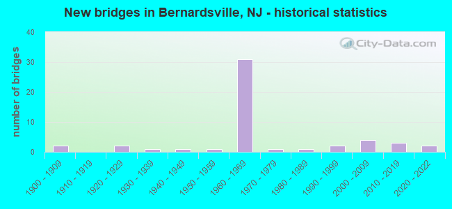
- New bridges - historical statistics
- 21900-1909
- 21920-1929
- 11930-1939
- 11940-1949
- 11950-1959
- 311960-1969
- 11970-1979
- 11980-1989
- 21990-1999
- 42000-2009
- 32010-2019
- 22020-2022

- Reconstructed bridges - Historical Statistics
- 11960-1969
- 11970-1979
- 21980-1989
- 71990-1999
- 32000-2009


- Bridge Condition - Deck
- 10.0%Very good
- 43.3%Good
- 23.3%Satisfactory
- 13.3%Fair
- 10.0%Poor

- Bridge Condition - Superstructure
- 3.0%Excellent
- 15.2%Very good
- 36.4%Good
- 27.3%Satisfactory
- 12.1%Fair
- 6.1%Poor

- Bridge Condition - Substructure
- 3.0%Excellent
- 15.2%Very good
- 27.3%Good
- 39.4%Satisfactory
- 12.1%Fair
- 3.0%Poor

- Bridge Condition - Channel
- 8.3%Very good
- 45.8%Good
- 41.7%Satisfactory
- 4.2%Fair

- Bridge Condition - Culverts
- 20.0%Good
- 60.0%Satisfactory
- 20.0%Fair
Find on map >> Show street view
Structure Number: 1815166, Location: AT I-287 EXIT 26 (Lat: 40.688869, Lng: -74.577200), Route carried "under" structure: County highway 525, Year Built: 1968, Structure Length: 0. m, Average Daily Traffic: 15,700 (year 2020), Truck Traffic: 4%, Features Intersected: MOUNT AIRY ROAD (CO.525), Facility Carried by Structure: I-287 N.B.
Minimum Vertical Clearance: 4.55m (14.93ft), Kilometerpoint: 15.031, Lanes on structure: 4, Lanes under structure: 3, Material/Design: Steel, Design/Construction: Stringer/Multi-beam, Length of Maximum Span: 19.2m (63.0ft)
Find on map >> Show street view
Structure Number: 1815167, Location: 4.4MI NORTH OF 202&206 (Lat: 40.689611, Lng: -74.577139), Route carried "under" structure: County highway 525, Year Built: 1968, Structure Length: 0. m, Average Daily Traffic: 15,400 (year 2018), Truck Traffic: 4%, Features Intersected: MT AIRY RD(CR 525), Facility Carried by Structure: I-287 SB
Minimum Vertical Clearance: 4.62m (15.16ft), Kilometerpoint: 15.047, Lanes on structure: 4, Lanes under structure: 3, Material/Design: Steel, Design/Construction: Stringer/Multi-beam, Length of Maximum Span: 19.5m (64.0ft)
Find on map >> Show street view
Structure Number: 1815171, Location: 1.48MI. NO. OF INTRCH 26 (Lat: 40.705611, Lng: -74.561569), Route carried "under" structure: Interstate 287, Year Built: 1968, Structure Length: 0. m, Average Daily Traffic: 48,542 (year 2021), Truck Traffic: 9%, Features Intersected: I-287 NB, Facility Carried by Structure: WEST OAK ST(CR624)
Minimum Vertical Clearance: 5.08m (16.67ft), Kilometerpoint: 44.997, Lanes on structure: 2, Lanes under structure: 3, Material/Design: Steel, Design/Construction: Stringer/Multi-beam, Length of Maximum Span: 21.9m (71.9ft)
Find on map >> Show street view
Structure Number: 1815172, Location: 5.7 MI NO. OF RT 18 JCT. (Lat: 40.705611, Lng: -74.561550), Route carried "under" structure: Interstate 287, Year Built: 1966, Structure Length: 0. m, Average Daily Traffic: 55,300 (year 2020), Truck Traffic: 9%, Features Intersected: I-287 SB, Facility Carried by Structure: W OAK ST (CR 624)
Minimum Vertical Clearance: 4.88m (16.01ft), Kilometerpoint: 44.997, Lanes on structure: 2, Lanes under structure: 3, Material/Design: Steel, Design/Construction: Stringer/Multi-beam, Length of Maximum Span: 21.9m (71.9ft)
Find on map >> Show street view
Structure Number: 1815174, Location: 1.93 MI NORTH OF EXIT 26 (Lat: 40.711889, Lng: -74.557261), Route carried "under" structure: Interstate 287, Year Built: 1966, Structure Length: 0. m, Average Daily Traffic: 90,086 (year 2021), Truck Traffic: 9%, Features Intersected: I-287, Facility Carried by Structure: WASHINGTON AVE
Minimum Vertical Clearance: 5.03m (16.50ft), Kilometerpoint: 45.721, Lanes on structure: 2, Lanes under structure: 6, Material/Design: Steel, Design/Construction: Stringer/Multi-beam, Length of Maximum Span: 33.5m (109.9ft)
Find on map >> Show street view
Structure Number: 1815176, Location: 2.11 MI N of Intrchg 26 (Lat: 40.713769, Lng: -74.555289), Route carried "under" structure: County highway 613, Year Built: 1966, Structure Length: 0. m, Average Daily Traffic: 8,225 (year 2021), Truck Traffic: 4%, Features Intersected: N.FINLEY AVE (CR 613), Facility Carried by Structure: I 287 NB
Minimum Vertical Clearance: 4.40m (14.44ft), Kilometerpoint: 6.033, Lanes on structure: 3, Lanes under structure: 2, Material/Design: Steel, Design/Construction: Stringer/Multi-beam, Length of Maximum Span: 20.7m (67.9ft)
Find on map >> Show street view
Structure Number: 1815177, Location: 1.35 MI S of Intchg 30 (Lat: 40.714469, Lng: -74.555369), Route carried "under" structure: County highway 613, Year Built: 1966, Structure Length: 0. m, Average Daily Traffic: 8,225 (year 2021), Truck Traffic: 4%, Features Intersected: N. FINLEY AVE (CR 613), Facility Carried by Structure: I 287 SB
Minimum Vertical Clearance: 4.47m (14.67ft), Kilometerpoint: 6.033, Lanes on structure: 3, Lanes under structure: 2, Material/Design: Steel, Design/Construction: Stringer/Multi-beam, Length of Maximum Span: 21.6m (70.9ft)
Find on map >> Show street view
Structure Number: 1815179, Location: 8.1 MI NORTH OF I-78 JCT (Lat: 40.721719, Lng: -74.547689), Route carried "under" structure: Interstate 287, Year Built: 1966, Structure Length: 0. m, Average Daily Traffic: 89,785 (year 2020), Truck Traffic: 9%, Features Intersected: I-287, Facility Carried by Structure: MADISONVILLE ROAD
Minimum Vertical Clearance: 4.98m (16.34ft), Kilometerpoint: 47.122, Lanes on structure: 2, Lanes under structure: 6, Material/Design: Steel, Design/Construction: Stringer/Multi-beam, Length of Maximum Span: 33.2m (108.9ft)
Find on map >> Show street view
Structure Number: 181518, Location: AT I-287 EXIT 30 (Lat: 40.728989, Lng: -74.539139), Route carried "under" structure: Interstate 287, Year Built: 1966, Structure Length: 0. m, Average Daily Traffic: 42,980 (year 2020), Truck Traffic: 9%, Features Intersected: I-287 NB, Facility Carried by Structure: NORTH MAPLE AVE.
Minimum Vertical Clearance: 5.25m (17.22ft), Kilometerpoint: 48.184, Lanes on structure: 2, Lanes under structure: 4, Material/Design: Steel, Design/Construction: Stringer/Multi-beam, Length of Maximum Span: 22.9m (75.1ft)
Find on map >> Show street view
Structure Number: 1815181, Location: AT I-287 EXIT 30 (Lat: 40.729200, Lng: -74.539319), Route carried "under" structure: Interstate 287, Year Built: 1966, Structure Length: 0. m, Average Daily Traffic: 43,950 (year 2020), Truck Traffic: 9%, Features Intersected: I-287 SB, Facility Carried by Structure: NORTH MAPLE AVE.
Minimum Vertical Clearance: 4.94m (16.21ft), Kilometerpoint: 48.184, Lanes on structure: 2, Lanes under structure: 3, Material/Design: Steel, Design/Construction: Stringer/Multi-beam, Length of Maximum Span: 22.9m (75.1ft)