Bridge Statistics for Bessemer, Alabama (AL)
Condition, Traffic, Stress, Structural Evaluation, Project Costs
- National Bridge Inventory (NBI) Statistics
- 161Number of bridges
- 2,392ft / 729mTotal length
- $320,452,000Total costs
- 2,593,758Total average daily traffic
- 466,681Total average daily truck traffic
- National Bridge Inventory (NBI) Registered Bridges for Bessemer
- No street view available for this location
- New bridges - historical statistics
- 21920-1929
- 161930-1939
- 71940-1949
- 151950-1959
- 31960-1969
- 571970-1979
- 451980-1989
- 11990-1999
- 92000-2009
- 62010-2019
- Reconstructed bridges - Historical Statistics
- 11960-1969
- 21970-1979
- 01980-1989
- 11990-1999
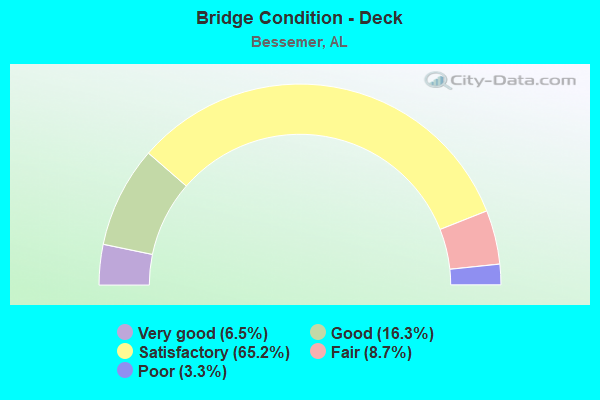
- Bridge Condition - Deck
- 6.5%Very good
- 16.3%Good
- 65.2%Satisfactory
- 8.7%Fair
- 3.3%Poor
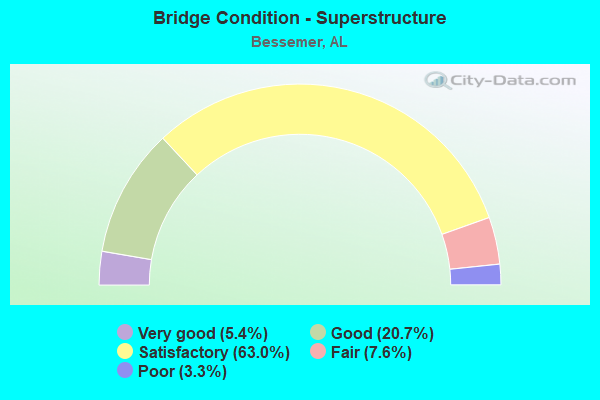
- Bridge Condition - Superstructure
- 5.4%Very good
- 20.7%Good
- 63.0%Satisfactory
- 7.6%Fair
- 3.3%Poor
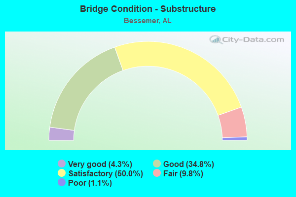
- Bridge Condition - Substructure
- 4.3%Very good
- 34.8%Good
- 50.0%Satisfactory
- 9.8%Fair
- 1.1%Poor
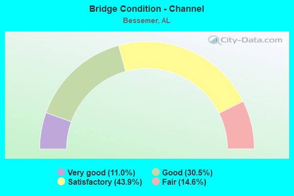
- Bridge Condition - Channel
- 11.0%Very good
- 30.5%Good
- 43.9%Satisfactory
- 14.6%Fair
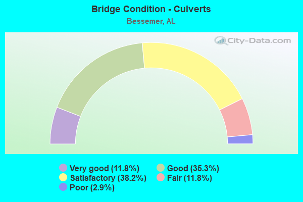
- Bridge Condition - Culverts
- 11.8%Very good
- 35.3%Good
- 38.2%Satisfactory
- 11.8%Fair
- 2.9%Poor
Find on map >> Show street view
Structure Number: 19945, Location: FREEMAN RD/FIVE MILE CK (Lat: 33.855778, Lng: -87.018528), Route carried "on" structure: City street , Year Built: 1970, Status: Posted for load, Structure Length: 0.98m (3.22ft), Average Daily Traffic: 30 (year 2021), Average Future Daily Traffic: 42 (year 2041), Features Intersected: FIVE MILE CREEK, Facility Carried by Structure: FREEMAN ROAD
Minimum Vertical Clearance: 30+ m (98+ ft), Kilometerpoint: 0.000, Lanes on structure: 1, Owner: City or Municipal Highway Agency, Approaching Roadway Width: 5.5m (18.0ft), Skew: 3 degrees, Material/Design: Steel, Design/Construction: Stringer/Multi-beam, Number Of Spans In Main Unit: 1, Length of Maximum Span: 9.8m (32.2ft), Curb-To-Curb Width: 3.7m (12.1ft), Out-to-Out Width: 4.1m (13.5ft)
Condition: Deck: Fair, Superstructure: Fair, Substructure: Fair, Channel: Satisfactory, Operating Rating: 13.6 metric tons, Method Used To Determine Operating Rating: Load Factor (LF), Inventory Rating: 8.2 metric tons, Method Used To Determine Inventory Rating: Load Factor (LF), Structural Evaluation: High priority of replacement, Deck Geometry: Meets minimum limits, Waterway Adequacy: Equal to present minimum criteria, Approach Roadway Alignment: Equal to present minimum criteria, Bridge Posting: Required (Relationship of Operating Rating to Maximum Legal Load: > 39.9% below), Length Of Structure Improvement: 1.64m (5.38ft), Designated Inspection Frequency: Every 24 months, Other Special Inspection Frequency: Every 12 months, Inspection Date: June 2021, Other Special Inspection Date: June 2021, Bridge Improvement Cost: $147,000, Roadway Improvement Cost: $15,000, Total Project Cost: $162,000 ( Estimate for 2022), Deck Structure Type: Wood or Timber, Wearing Surface/Protective System: Wearing Surface: Wood or Timber
Find on map >> Show street view
Structure Number: 203, Location: RAMP I-459 SO.TO 59 SO. (Lat: 33.336928, Lng: -87.040000), Route carried "on" structure: Ramp Interstate 459, Year Built: 1978, Status: Open, Structure Length: 0.91m (2.99ft), Average Daily Traffic: 6,371 (year 2021), Truck Traffic: 26%, Average Future Daily Traffic: 7,882 (year 2041), Design Load: HS 20, Features Intersected: COX SPRINGS BRANCH
Minimum Vertical Clearance: 30.18m (99.02ft), Kilometerpoint: 170.188, Lanes on structure: 2, Base Highway Network: Yes, Owner: State Highway Agency, Approaching Roadway Width: 10.1m (33.1ft), Skew: 4 degrees, Material/Design: Concrete, Design/Construction: Culvert, Number Of Spans In Main Unit: 2, Length of Maximum Span: 3.0m (9.8ft), Curb-To-Curb Width: 4.5m (14.8ft), Out-to-Out Width: 304.5m (999.0ft)
Condition: Channel: Very good, Culverts: Good, Operating Rating: 45.2 metric tons, Method Used To Determine Operating Rating: Load Factor (LF), Inventory Rating: 27.0 metric tons, Method Used To Determine Inventory Rating: Load Factor (LF), Structural Evaluation: Equal to present minimum criteria, Deck Geometry: High priority of replacement, Waterway Adequacy: Equal to present desirable criteria, Approach Roadway Alignment: Equal to present desirable criteria, Length Of Structure Improvement: 1.59m (5.22ft), Designated Inspection Frequency: Every 24 months, Inspection Date: Febuary 2021, Bridge Improvement Cost: $842,000, Roadway Improvement Cost: $84,000, Total Project Cost: $926,000 ( Estimate for 2022)
Find on map >> Show street view
Structure Number: 20311, Location: 0.3 MI. NO. BATTON ROAD (Lat: 33.340817, Lng: -86.954094), Route carried "on" structure: City street , Year Built: 2008, Status: Open, Structure Length: 0.98m (3.22ft), Average Daily Traffic: 500 (year 2021), Average Future Daily Traffic: 700 (year 2041), Design Load: HS 20, Features Intersected: BRANCH, Facility Carried by Structure: NIXON ROAD
Minimum Vertical Clearance: 30+ m (98+ ft), Kilometerpoint: 0.000, Lanes on structure: 2, Owner: City or Municipal Highway Agency, Approaching Roadway Width: 6.7m (22.0ft), Skew: 1 degrees, Material/Design: Concrete, Design/Construction: Channel Beam, Number Of Spans In Main Unit: 2, Length of Maximum Span: 4.5m (14.8ft), Curb-To-Curb Width: 7.0m (23.0ft), Out-to-Out Width: 7.9m (25.9ft)
Condition: Deck: Good, Superstructure: Very good, Substructure: Good, Channel: Good, Operating Rating: 83.8 metric tons, Method Used To Determine Operating Rating: Load Factor (LF), Inventory Rating: 50.2 metric tons, Method Used To Determine Inventory Rating: Load Factor (LF), Structural Evaluation: Better than present minimum criteria, Deck Geometry: Meets minimum limits, Waterway Adequacy: Equal to present desirable criteria, Approach Roadway Alignment: Equal to present desirable criteria, Length Of Structure Improvement: 1.64m (5.38ft), Designated Inspection Frequency: Every 24 months, Inspection Date: June 2021, Bridge Improvement Cost: $293,000, Roadway Improvement Cost: $29,000, Total Project Cost: $322,000 ( Estimate for 2022), Deck Structure Type: Concrete Precast Panels
Find on map >> Show street view
Structure Number: 20352, Location: 0.6 MI FROM DICKEY SPRING (Lat: 33.331725, Lng: -86.939378), Route carried "on" structure: City street , Year Built: 1975, Status: Posted for load, Structure Length: 1.37m (4.49ft), Average Daily Traffic: 500 (year 2021), Truck Traffic: 1%, Average Future Daily Traffic: 700 (year 2041), Design Load: H 20, Features Intersected: UT SHADES CK, Facility Carried by Structure: PLEASANT HILL RD
Minimum Vertical Clearance: 30+ m (98+ ft), Kilometerpoint: 0.000, Lanes on structure: 2, Owner: City or Municipal Highway Agency, Approaching Roadway Width: 6.7m (22.0ft), Material/Design: Concrete, Design/Construction: Channel Beam, Number Of Spans In Main Unit: 3, Length of Maximum Span: 4.6m (15.1ft), Curb-To-Curb Width: 7.2m (23.6ft), Out-to-Out Width: 7.7m (25.3ft)
Condition: Deck: Satisfactory, Superstructure: Fair, Substructure: Good, Channel: Fair, Operating Rating: 27.9 metric tons, Method Used To Determine Operating Rating: Load Factor (LF), Inventory Rating: 16.7 metric tons, Method Used To Determine Inventory Rating: Load Factor (LF), Structural Evaluation: Somewhat better than minimum adequacy, Deck Geometry: Meets minimum limits, Waterway Adequacy: Equal to present desirable criteria, Approach Roadway Alignment: Equal to present desirable criteria, Bridge Posting: Required (Relationship of Operating Rating to Maximum Legal Load: 30.0 - 39.9% below), Length Of Structure Improvement: 2.05m (6.73ft), Designated Inspection Frequency: Every 24 months, Other Special Inspection Frequency: Every 12 months, Inspection Date: June 2021, Other Special Inspection Date: June 2021, Bridge Improvement Cost: $351,000, Roadway Improvement Cost: $35,000, Total Project Cost: $386,000 ( Estimate for 2022), Deck Structure Type: Concrete Precast Panels
Find on map >> Show street view
Structure Number: 20413, Location: 0.8 MI S DICKEY SPRINGS R (Lat: 33.318250, Lng: -86.979889), Route carried "on" structure: County highway 53, Year Built: 2010, Status: Open, Structure Length: 1.42m (4.66ft), Average Daily Traffic: 2,060 (year 2020), Truck Traffic: 5%, Average Future Daily Traffic: 2,255 (year 2040), Design Load: HS 20, Features Intersected: CLEAR BRANCH, Facility Carried by Structure: POCAHONTAS ROAD
Minimum Vertical Clearance: 30+ m (98+ ft), Kilometerpoint: 0.000, Lanes on structure: 2, Owner: County Highway Agency, Approaching Roadway Width: 6.6m (21.7ft), Material/Design: Concrete, Design/Construction: Culvert, Number Of Spans In Main Unit: 4, Length of Maximum Span: 3.0m (9.8ft)
Condition: Channel: Good, Culverts: Very good, Operating Rating: 57.3 metric tons, Method Used To Determine Operating Rating: Load Factor (LF), Inventory Rating: 34.4 metric tons, Method Used To Determine Inventory Rating: Load Factor (LF), Structural Evaluation: Equal to present desirable criteria, Waterway Adequacy: Better than present minimum criteria, Approach Roadway Alignment: Equal to present desirable criteria, Length Of Structure Improvement: 2.09m (6.86ft), Designated Inspection Frequency: Every 24 months, Inspection Date: April 2020, Bridge Improvement Cost: $567,000, Roadway Improvement Cost: $57,000, Total Project Cost: $624,000 ( Estimate for 2022)
Find on map >> Show street view
Structure Number: 2087, Location: 300' W. 5th ave North (Lat: 33.408636, Lng: -86.952836), Route carried "on" structure: City street , Year Built: 2018, Status: Open, Structure Length: 0.95m (3.12ft), Average Daily Traffic: 79 (year 2020), Truck Traffic: 1%, Average Future Daily Traffic: 117 (year 2040), Design Load: HS 20, Features Intersected: Unnamed creek, Facility Carried by Structure: 23rd st. north
Minimum Vertical Clearance: 30+ m (98+ ft), Kilometerpoint: 0.499, Lanes on structure: 2, Owner: City or Municipal Highway Agency, Approaching Roadway Width: 6.1m (20.0ft), Skew: 4 degrees, Material/Design: Concrete, Design/Construction: Culvert, Number Of Spans In Main Unit: 2, Length of Maximum Span: 4.8m (15.7ft), Curb-To-Curb Width: 8.6m (28.2ft), Out-to-Out Width: 9.1m (29.9ft)
Condition: Channel: Very good, Culverts: Good, Operating Rating: 45.9 metric tons, Method Used To Determine Operating Rating: Load Factor (LF), Inventory Rating: 27.5 metric tons, Method Used To Determine Inventory Rating: Load Factor (LF), Structural Evaluation: Equal to present minimum criteria, Deck Geometry: Better than present minimum criteria, Waterway Adequacy: Equal to present minimum criteria, Approach Roadway Alignment: Equal to present desirable criteria, Length Of Structure Improvement: 1.63m (5.35ft), Designated Inspection Frequency: Every 24 months, Inspection Date: May 2020, Bridge Improvement Cost: $422,000, Roadway Improvement Cost: $42,000, Total Project Cost: $464,000 ( Estimate for 2022)
Find on map >> Show street view
Structure Number: 20871, Location: 3rd Ave No. & 12th st. (Lat: 33.394900, Lng: -86.959744), Route carried "on" structure: City street , Year Built: 2017, Status: Open, Structure Length: 0.75m (2.46ft), Average Daily Traffic: 626 (year 2021), Truck Traffic: 12%, Average Future Daily Traffic: 923 (year 2041), Design Load: HS 20, Features Intersected: HALLS CREEK, Facility Carried by Structure: 3RD AVENUE
Minimum Vertical Clearance: 30+ m (98+ ft), Kilometerpoint: 1.099, Lanes on structure: 2, Owner: City or Municipal Highway Agency, Approaching Roadway Width: 7.3m (24.0ft), Material/Design: Concrete, Design/Construction: Culvert, Number Of Spans In Main Unit: 2, Length of Maximum Span: 3.7m (12.1ft), Curb or Sidewalk Widths: Left: 0.0m, Right: 2.7m (8.9ft), Curb-To-Curb Width: 9.4m (30.8ft), Out-to-Out Width: 12.8m (42.0ft)
Condition: Channel: Good, Culverts: Good, Operating Rating: 69.1 metric tons, Method Used To Determine Operating Rating: Load Factor (LF), Inventory Rating: 41.5 metric tons, Method Used To Determine Inventory Rating: Load Factor (LF), Structural Evaluation: Better than present minimum criteria, Deck Geometry: Equal to present minimum criteria, Waterway Adequacy: Equal to present minimum criteria, Approach Roadway Alignment: Equal to present desirable criteria, Length Of Structure Improvement: 1.39m (4.56ft), Designated Inspection Frequency: Every 24 months, Inspection Date: March 2021, Bridge Improvement Cost: $330,000, Roadway Improvement Cost: $33,000, Total Project Cost: $363,000 ( Estimate for 2022), Deck Structure Type: Concrete Cast-file-Place
Find on map >> Show street view
Structure Number: 20872, Location: 8TH Ave. NO. & 13th ST. (Lat: 33.398861, Lng: -86.965281), Route carried "on" structure: City street , Year Built: 2017, Status: Open, Structure Length: 0.94m (3.08ft), Average Daily Traffic: 372 (year 2021), Truck Traffic: 4%, Average Future Daily Traffic: 549 (year 2041), Design Load: HS 20, Features Intersected: HALLS CREEK, Facility Carried by Structure: 8TH AVENUE
Minimum Vertical Clearance: 30+ m (98+ ft), Kilometerpoint: 0.999, Lanes on structure: 2, Owner: City or Municipal Highway Agency, Approaching Roadway Width: 6.2m (20.3ft), Material/Design: Concrete, Design/Construction: Culvert, Number Of Spans In Main Unit: 3, Length of Maximum Span: 3.0m (9.8ft), Curb-To-Curb Width: 8.5m (27.9ft), Out-to-Out Width: 9.0m (29.5ft)
Condition: Channel: Good, Culverts: Very good, Operating Rating: 35.5 metric tons, Method Used To Determine Operating Rating: Load Factor (LF), Inventory Rating: 21.3 metric tons, Method Used To Determine Inventory Rating: Load Factor (LF), Structural Evaluation: Equal to present minimum criteria, Deck Geometry: Equal to present minimum criteria, Waterway Adequacy: Equal to present minimum criteria, Approach Roadway Alignment: Equal to present minimum criteria, Length Of Structure Improvement: 1.62m (5.31ft), Designated Inspection Frequency: Every 24 months, Inspection Date: March 2021, Bridge Improvement Cost: $271,000, Roadway Improvement Cost: $27,000, Total Project Cost: $298,000 ( Estimate for 2022), Deck Structure Type: Concrete Cast-file-Place
Find on map >> Show street view
Structure Number: 1399, Location: @ 19TH STREET (BESSEMER) (Lat: 33.408069, Lng: -86.959736), Route carried "under" structure: ServiceCity street , Year Built: 1936, Structure Length: 0. m, Average Daily Traffic: 500 (year 2021), Truck Traffic: 3%, Features Intersected: L*N FRISCO * SOU RR, Facility Carried by Structure: US 11
Minimum Vertical Clearance: 6.78m (22.24ft), Kilometerpoint: 0.100, Lanes on structure: 4, Lanes under structure: 2, Material/Design: Steel, Design/Construction: Stringer/Multi-beam, Length of Maximum Span: 16.8m (55.1ft)
Find on map >> Show street view
Structure Number: 14, Location: BHAM SOU RR * US 11 (Lat: 33.420744, Lng: -86.949469), Route carried "under" structure: US 11, Year Built: 1936, Structure Length: 0. m, Average Daily Traffic: 20,070 (year 2013), Truck Traffic: 3%, Features Intersected: US 11, Facility Carried by Structure: RR
Minimum Vertical Clearance: 4.36m (14.30ft), Kilometerpoint: 201.088, Lanes under structure: 4, Material/Design: Steel continuous, Design/Construction: Girder and Floorbeam System, Length of Maximum Span: 29.3m (96.1ft)
Find on map >> Show street view
Structure Number: 1402, Location: AL 5 * WOODWARD RR (Lat: 33.425886, Lng: -86.945339), Route carried "under" structure: US 11, Year Built: 1936, Structure Length: 0. m, Average Daily Traffic: 20,070 (year 2013), Truck Traffic: 3%, Features Intersected: US 11, Facility Carried by Structure: RR
Minimum Vertical Clearance: 4.36m (14.30ft), Kilometerpoint: 201.651, Lanes under structure: 4, Material/Design: Steel continuous, Design/Construction: Girder and Floorbeam System, Length of Maximum Span: 24.7m (81.0ft)
Find on map >> Show street view
Structure Number: 8554, Location: 1.5 MI NO JEFF TUSCCO LN (Lat: 33.301547, Lng: -87.070681), Route carried "under" structure: Interstate 20, Year Built: 1965, Structure Length: 0. m, Average Daily Traffic: 60,490 (year 2021), Truck Traffic: 27%, Features Intersected: I - 59, Facility Carried by Structure: LOWETOWN ROAD
Minimum Vertical Clearance: 5.15m (16.90ft), Kilometerpoint: 164.877, Lanes on structure: 2, Lanes under structure: 6, Material/Design: Concrete continuous, Design/Construction: Tee Beam, Length of Maximum Span: 22.3m (73.2ft)
Find on map >> Show street view
Structure Number: 11329, Location: I59 * ACADEMY DRIVE (Lat: 33.365556, Lng: -87.001528), Route carried "under" structure: US 11, Year Built: 1975, Structure Length: 0. m, Average Daily Traffic: 20,000 (year 2021), Truck Traffic: 19%, Features Intersected: ACADEMY DRIVE (US 11), Facility Carried by Structure: I 59/20
Minimum Vertical Clearance: 30+ m (98+ ft), Kilometerpoint: 193.121, Lanes on structure: 2, Lanes under structure: 4, Material/Design: Steel continuous, Design/Construction: Stringer/Multi-beam, Length of Maximum Span: 23.3m (76.4ft)
Find on map >> Show street view
Structure Number: 1133, Location: I59 * ACADEMY DRIVE (Lat: 33.364722, Lng: -87.001111), Route carried "under" structure: US 11, Year Built: 1975, Structure Length: 0. m, Average Daily Traffic: 20,000 (year 2021), Truck Traffic: 19%, Features Intersected: ACADEMY DRIVE (US 11), Facility Carried by Structure: I 59/20
Minimum Vertical Clearance: 30+ m (98+ ft), Kilometerpoint: 193.123, Lanes on structure: 2, Lanes under structure: 4, Material/Design: Steel continuous, Design/Construction: Stringer/Multi-beam, Length of Maximum Span: 23.3m (76.4ft)
Find on map >> Show street view
Structure Number: 11739, Location: I459 * I59 AT MCCALLA (Lat: 33.342967, Lng: -87.028031), Route carried "under" structure: Interstate 20, Year Built: 1977, Structure Length: 0. m, Average Daily Traffic: 43,380 (year 2020), Truck Traffic: 21%, Features Intersected: I 59, Facility Carried by Structure: I-459
Minimum Vertical Clearance: 4.97m (16.31ft), Kilometerpoint: 170.751, Lanes on structure: 2, Lanes under structure: 4, Material/Design: Steel continuous, Design/Construction: Stringer/Multi-beam, Length of Maximum Span: 27.1m (88.9ft)
Find on map >> Show street view
Structure Number: 11748, Location: POWDER PLANT ROAD (Lat: 33.354161, Lng: -87.013800), Route carried "under" structure: Interstate 20, Year Built: 1977, Structure Length: 0. m, Average Daily Traffic: 43,380 (year 2021), Truck Traffic: 21%, Features Intersected: I - 20/59, Facility Carried by Structure: POWDER PLANT RD
Minimum Vertical Clearance: 30+ m (98+ ft), Kilometerpoint: 172.522, Lanes on structure: 2, Lanes under structure: 4, Material/Design: Steel continuous, Design/Construction: Stringer/Multi-beam, Length of Maximum Span: 27.4m (89.9ft)
Find on map >> Show street view
Structure Number: 11749, Location: I59 * DOLONAH ROAD (Lat: 33.395278, Lng: -86.982778), Route carried "under" structure: City street , Year Built: 1977, Structure Length: 0. m, Average Daily Traffic: 5,000 (year 2021), Truck Traffic: 2%, Features Intersected: DOLONAH ROAD, Facility Carried by Structure: I - 20/59 SOUTH
Minimum Vertical Clearance: 6.17m (20.24ft), Kilometerpoint: 0.010, Lanes on structure: 2, Lanes under structure: 4, Material/Design: Steel continuous, Design/Construction: Stringer/Multi-beam, Length of Maximum Span: 27.8m (91.2ft)
Find on map >> Show street view
Structure Number: 1175, Location: I59 * DOLONAH ROAD (Lat: 33.395278, Lng: -86.982778), Route carried "under" structure: City street , Year Built: 1977, Structure Length: 0. m, Average Daily Traffic: 4,000 (year 2021), Truck Traffic: 2%, Features Intersected: DOLONAH ROAD, Facility Carried by Structure: I - 20/59 NORTH
Minimum Vertical Clearance: 6.17m (20.24ft), Kilometerpoint: 0.010, Lanes on structure: 2, Lanes under structure: 4, Material/Design: Steel continuous, Design/Construction: Stringer/Multi-beam, Length of Maximum Span: 27.8m (91.2ft)
Find on map >> Show street view
Structure Number: 11753, Location: I59 * 11TH ST BESS. (Lat: 33.402778, Lng: -86.977222), Route carried "under" structure: City street , Year Built: 1977, Structure Length: 0. m, Average Daily Traffic: 500 (year 2001), Truck Traffic: 1%, Features Intersected: 11TH ST BESSEMER, Facility Carried by Structure: I - 20/59 SOUTH
Minimum Vertical Clearance: 4.65m (15.26ft), Kilometerpoint: 0.010, Lanes on structure: 2, Lanes under structure: 2, Material/Design: Steel continuous, Design/Construction: Stringer/Multi-beam, Length of Maximum Span: 21.3m (69.9ft)
Find on map >> Show street view
Structure Number: 11754, Location: I59 * 11TH ST BESS. (Lat: 33.402778, Lng: -86.977222), Route carried "under" structure: City street , Year Built: 1977, Structure Length: 0. m, Average Daily Traffic: 500 (year 2021), Truck Traffic: 1%, Features Intersected: 11TH ST BESSEMER, Facility Carried by Structure: I -20/59 NORTH
Minimum Vertical Clearance: 4.65m (15.26ft), Kilometerpoint: 0.000, Lanes on structure: 2, Lanes under structure: 2, Material/Design: Steel continuous, Design/Construction: Stringer/Multi-beam, Length of Maximum Span: 21.3m (69.9ft)
Find on map >> Show street view
Structure Number: 11755, Location: I59 * 15TH ST BESS (Lat: 33.407222, Lng: -86.973611), Route carried "under" structure: City street 20, Year Built: 1977, Structure Length: 0. m, Average Daily Traffic: 7,000 (year 2021), Truck Traffic: 19%, Features Intersected: 15TH ST BESSEMER
Minimum Vertical Clearance: 30+ m (98+ ft), Kilometerpoint: 179.480, Lanes on structure: 3, Lanes under structure: 2, Material/Design: Steel continuous, Design/Construction: Stringer/Multi-beam, Length of Maximum Span: 25.3m (83.0ft)
Find on map >> Show street view
Structure Number: 11756, Location: I59 * 15TH ST BESS (Lat: 33.407222, Lng: -86.973611), Route carried "under" structure: City street 20, Year Built: 1977, Structure Length: 0. m, Average Daily Traffic: 7,000 (year 2021), Truck Traffic: 19%, Features Intersected: 15TH ST BESSEMER
Minimum Vertical Clearance: 30+ m (98+ ft), Kilometerpoint: 179.480, Lanes on structure: 3, Lanes under structure: 2, Material/Design: Steel continuous, Design/Construction: Stringer/Multi-beam, Length of Maximum Span: 25.3m (83.0ft)
Find on map >> Show street view
Structure Number: 11757, Location: I 59 * 18TH * 19TH STREET (Lat: 33.410000, Lng: -86.971389), Route carried "under" structure: City street , Year Built: 1977, Structure Length: 0. m, Average Daily Traffic: 2,000 (year 2021), Features Intersected: 18TH * 19TH STREETS, Facility Carried by Structure: I - 20/59 SOUTH
Minimum Vertical Clearance: 5.03m (16.50ft), Kilometerpoint: 0.000, Lanes on structure: 2, Lanes under structure: 3, Material/Design: Steel continuous, Design/Construction: Stringer/Multi-beam, Length of Maximum Span: 24.4m (80.1ft)
Find on map >> Show street view
Structure Number: 11757, Location: I 59 * 18TH * 19TH STREET (Lat: 33.410000, Lng: -86.971389), Route carried "under" structure: City street , Year Built: 1977, Structure Length: 0. m, Average Daily Traffic: 2,000 (year 2021), Truck Traffic: 1%, Features Intersected: 18TH * 19TH STREETS, Facility Carried by Structure: I - 20/59 SOUTH
Minimum Vertical Clearance: 5.03m (16.50ft), Kilometerpoint: 0.000, Lanes on structure: 2, Lanes under structure: 3, Material/Design: Steel continuous, Design/Construction: Stringer/Multi-beam, Length of Maximum Span: 24.4m (80.1ft)
Find on map >> Show street view
Structure Number: 11758, Location: I59* 18TH * 19TH STS (Lat: 33.410000, Lng: -86.971389), Route carried "under" structure: City street , Year Built: 1977, Structure Length: 0. m, Average Daily Traffic: 2,000 (year 2021), Truck Traffic: 10%, Features Intersected: 18TH * 19TH STR, Facility Carried by Structure: I - 20/59 NORTH
Minimum Vertical Clearance: 5.03m (16.50ft), Kilometerpoint: 0.000, Lanes on structure: 2, Lanes under structure: 3, Material/Design: Steel continuous, Design/Construction: Stringer/Multi-beam, Length of Maximum Span: 24.4m (80.1ft)
Find on map >> Show street view
Structure Number: 12107, Location: I59 * 24TH ST (Lat: 33.415833, Lng: -86.913611), Route carried "under" structure: City street 20, Year Built: 1979, Structure Length: 0. m, Average Daily Traffic: 23,500 (year 2021), Truck Traffic: 15%, Features Intersected: 24TH ST BESSEMER
Minimum Vertical Clearance: 30+ m (98+ ft), Kilometerpoint: 181.051, Lanes on structure: 2, Lanes under structure: 2, Material/Design: Steel continuous, Design/Construction: Stringer/Multi-beam, Length of Maximum Span: 25.6m (84.0ft)
Find on map >> Show street view
Structure Number: 12108, Location: I59* 24TH ST (Lat: 33.415833, Lng: -86.913611), Route carried "under" structure: City street 20, Year Built: 1979, Structure Length: 0. m, Average Daily Traffic: 23,500 (year 2021), Truck Traffic: 16%, Features Intersected: 24TH ST BESSEMER
Minimum Vertical Clearance: 30+ m (98+ ft), Kilometerpoint: 181.051, Lanes on structure: 2, Lanes under structure: 2, Material/Design: Steel continuous, Design/Construction: Stringer/Multi-beam, Length of Maximum Span: 25.6m (84.0ft)
Find on map >> Show street view
Structure Number: 12109, Location: I59 * VALLEY CREEK (Lat: 33.421200, Lng: -86.961000), Route carried "under" structure: City street , Year Built: 1979, Structure Length: 0. m, Average Daily Traffic: 150 (year 2002), Truck Traffic: 1%, Features Intersected: VALLEY CREEK, Facility Carried by Structure: I59/20 SOUTH
Minimum Vertical Clearance: 5.92m (19.42ft), Kilometerpoint: 0.010, Lanes on structure: 2, Lanes under structure: 2, Material/Design: Steel continuous, Design/Construction: Stringer/Multi-beam, Length of Maximum Span: 36.6m (120.1ft)
Find on map >> Show street view
Structure Number: 1211, Location: I59 * VALLEY CREEK (Lat: 33.419600, Lng: -86.961700), Route carried "under" structure: City street , Year Built: 1979, Structure Length: 0. m, Average Daily Traffic: 150 (year 1994), Truck Traffic: 15%, Features Intersected: VALLEY CREEK, Facility Carried by Structure: I59/20 NORTH
Minimum Vertical Clearance: 5.61m (18.41ft), Kilometerpoint: 0.010, Lanes on structure: 2, Lanes under structure: 2, Material/Design: Steel continuous, Design/Construction: Stringer/Multi-beam, Length of Maximum Span: 36.6m (120.1ft)
Find on map >> Show street view
Structure Number: 12113, Location: I59 * 18TH AVE (Lat: 33.426111, Lng: -86.955000), Route carried "under" structure: Bypass City street , Year Built: 1979, Structure Length: 0. m, Average Daily Traffic: 3,500 (year 2021), Truck Traffic: 5%, Features Intersected: 18TH AVE BESSEMER, Facility Carried by Structure: I - 20/59 SOUTH
Minimum Vertical Clearance: 5.11m (16.77ft), Kilometerpoint: 0.010, Lanes on structure: 2, Lanes under structure: 4, Toll: Toll bridge, Material/Design: Steel continuous, Design/Construction: Stringer/Multi-beam, Length of Maximum Span: 43.3m (142.1ft)
Find on map >> Show street view
Structure Number: 12114, Location: I59 * 18TH AVE (Lat: 33.426111, Lng: -86.955000), Route carried "under" structure: City street , Year Built: 1979, Structure Length: 0. m, Average Daily Traffic: 3,500 (year 2021), Truck Traffic: 1%, Features Intersected: 18TH AVE BESSEMER, Facility Carried by Structure: I - 20/59 NORTH
Minimum Vertical Clearance: 4.27m (14.01ft), Kilometerpoint: 0.010, Lanes on structure: 2, Lanes under structure: 4, Toll: Toll bridge, Material/Design: Steel continuous, Design/Construction: Stringer/Multi-beam, Length of Maximum Span: 43.3m (142.1ft)
Find on map >> Show street view
Structure Number: 12695, Location: I459 * OLD US11 (Lat: 33.337133, Lng: -87.010447), Route carried "under" structure: Alternate County highway , Year Built: 1982, Structure Length: 0. m, Average Daily Traffic: 3,500 (year 2020), Truck Traffic: 20%, Features Intersected: OLD US 11, Facility Carried by Structure: I - 459 SOUTH
Minimum Vertical Clearance: 5.18m (16.99ft), Kilometerpoint: 0.000, Lanes on structure: 2, Lanes under structure: 2, Material/Design: Steel continuous, Design/Construction: Stringer/Multi-beam, Length of Maximum Span: 30.5m (100.1ft)
Find on map >> Show street view
Structure Number: 12696, Location: I459 * OLD US11 (Lat: 33.336969, Lng: -87.010714), Route carried "under" structure: Alternate County highway , Year Built: 1982, Structure Length: 0. m, Average Daily Traffic: 3,600 (year 2020), Truck Traffic: 20%, Features Intersected: OLD US 11, Facility Carried by Structure: I - 459 NORTH
Minimum Vertical Clearance: 5.18m (16.99ft), Kilometerpoint: 0.000, Lanes on structure: 2, Lanes under structure: 2, Material/Design: Steel continuous, Design/Construction: Stringer/Multi-beam, Length of Maximum Span: 30.5m (100.1ft)
Find on map >> Show street view
Structure Number: 127, Location: CO RD 18 * I459 (Lat: 33.332569, Lng: -86.997931), Route carried "under" structure: Interstate 459, Year Built: 1982, Structure Length: 0. m, Average Daily Traffic: 52,730 (year 2020), Truck Traffic: 20%, Features Intersected: I 459, Facility Carried by Structure: CO RD 18
Minimum Vertical Clearance: 5.28m (17.32ft), Kilometerpoint: 2.886, Lanes on structure: 4, Lanes under structure: 4, Material/Design: Steel continuous, Design/Construction: Stringer/Multi-beam, Length of Maximum Span: 30.5m (100.1ft)
Find on map >> Show street view
Structure Number: 12701, Location: POCOHANTAS RD * I459 (Lat: 33.333161, Lng: -86.982883), Route carried "under" structure: Interstate 459, Year Built: 1982, Structure Length: 0. m, Average Daily Traffic: 52,730 (year 2020), Truck Traffic: 20%, Features Intersected: I 459, Facility Carried by Structure: POCOHANTAS RD
Minimum Vertical Clearance: 5.79m (19.00ft), Kilometerpoint: 4.273, Lanes on structure: 2, Lanes under structure: 4, Material/Design: Steel continuous, Design/Construction: Stringer/Multi-beam, Length of Maximum Span: 27.7m (90.9ft)
Find on map >> Show street view
Structure Number: 12702, Location: CO RD 26 * I459 (Lat: 33.333881, Lng: -86.961272), Route carried "under" structure: Interstate 459, Year Built: 1982, Structure Length: 0. m, Average Daily Traffic: 52,730 (year 2021), Truck Traffic: 20%, Features Intersected: I - 459, Facility Carried by Structure: VULCAN RD
Minimum Vertical Clearance: 8.15m (26.74ft), Kilometerpoint: 6.421, Lanes on structure: 2, Lanes under structure: 4, Material/Design: Steel continuous, Design/Construction: Stringer/Multi-beam, Length of Maximum Span: 27.4m (89.9ft)
Find on map >> Show street view
Structure Number: 12712, Location: I459 * CO RD 52(MORGAN RD (Lat: 33.339122, Lng: -86.920547), Route carried "under" structure: Business County highway , Year Built: 1982, Structure Length: 0. m, Average Daily Traffic: 5,000 (year 2002), Truck Traffic: 10%, Features Intersected: CO RD 52, Facility Carried by Structure: I 459
Minimum Vertical Clearance: 8.78m (28.81ft), Kilometerpoint: 0.161, Lanes on structure: 2, Lanes under structure: 4, Material/Design: Steel continuous, Design/Construction: Stringer/Multi-beam, Length of Maximum Span: 34.1m (111.9ft)
Find on map >> Show street view
Structure Number: 12713, Location: I459 * CO RD 52(MORGAN RD (Lat: 33.338928, Lng: -86.920319), Route carried "under" structure: Business County highway , Year Built: 1982, Structure Length: 0. m, Average Daily Traffic: 1,000 (year 2002), Truck Traffic: 1%, Features Intersected: CO RD 52, Facility Carried by Structure: I459
Minimum Vertical Clearance: 7.56m (24.80ft), Kilometerpoint: 0.161, Lanes on structure: 2, Lanes under structure: 4, Material/Design: Steel continuous, Design/Construction: Stringer/Multi-beam, Length of Maximum Span: 34.1m (111.9ft)
Find on map >> Show street view
Structure Number: 12908, Location: GREENWOOD DR * I459 (Lat: 33.336822, Lng: -86.930867), Route carried "under" structure: Interstate 459, Year Built: 1983, Structure Length: 0. m, Average Daily Traffic: 52,730 (year 2021), Truck Traffic: 20%, Features Intersected: I - 459, Facility Carried by Structure: GREENWOOD DR
Minimum Vertical Clearance: 5.31m (17.42ft), Kilometerpoint: 8.996, Lanes on structure: 2, Lanes under structure: 4, Material/Design: Steel continuous, Design/Construction: Stringer/Multi-beam, Length of Maximum Span: 35.1m (115.2ft)
Find on map >> Show street view
Structure Number: 12911, Location: I459 * PARKWOOD RD (Lat: 33.341567, Lng: -86.902467), Route carried "under" structure: Interstate 459, Year Built: 1983, Structure Length: 0. m, Average Daily Traffic: 54,400 (year 2020), Truck Traffic: 20%, Features Intersected: I 459, Facility Carried by Structure: PARKWOOD RD
Minimum Vertical Clearance: 5.41m (17.75ft), Kilometerpoint: 11.909, Lanes on structure: 2, Lanes under structure: 6, Material/Design: Steel continuous, Design/Construction: Stringer/Multi-beam, Length of Maximum Span: 28.3m (92.8ft)
Find on map >> Show street view
Structure Number: 12918, Location: ROCK MT LAKE EXIT (Lat: 33.324192, Lng: -87.048136), Route carried "under" structure: Interstate 20, Year Built: 1983, Structure Length: 0. m, Average Daily Traffic: 63,710 (year 2021), Truck Traffic: 26%, Features Intersected: I - 20/59, Facility Carried by Structure: McASHAN DRIVE
Minimum Vertical Clearance: 30+ m (98+ ft), Kilometerpoint: 168.740, Lanes on structure: 2, Lanes under structure: 6, Material/Design: Prestressed concrete, Design/Construction: Stringer/Multi-beam, Length of Maximum Span: 21.3m (69.9ft)
Find on map >> Show street view
Structure Number: 17125, Location: BESSEMER (Lat: 33.386089, Lng: -86.988144), Route carried "under" structure: Interstate 20, Year Built: 2003, Structure Length: 0. m, Average Daily Traffic: 46,720 (year 2021), Truck Traffic: 21%, Features Intersected: I - 20, Facility Carried by Structure: SPLASH ADV PKWY
Minimum Vertical Clearance: 5.43m (17.81ft), Kilometerpoint: 177.028, Lanes on structure: 6, Lanes under structure: 4, Material/Design: Prestressed concrete, Design/Construction: Stringer/Multi-beam, Length of Maximum Span: 28.1m (92.2ft)