Bridge Statistics for Boonton, New Jersey (NJ)
Condition, Traffic, Stress, Structural Evaluation, Project Costs
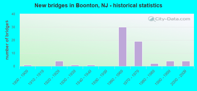
- New bridges - historical statistics
- 11900-1909
- 41920-1929
- 11930-1939
- 11940-1949
- 301960-1969
- 191970-1979
- 21980-1989
- 41990-1999
- 42000-2009

- Reconstructed bridges - Historical Statistics
- 11960-1969
- 11970-1979
- 131980-1989
- 21990-1999
- 12000-2009
- 12010-2019


- Bridge Condition - Deck
- 5.6%Very good
- 33.3%Good
- 41.7%Satisfactory
- 16.7%Fair
- 2.8%Poor

- Bridge Condition - Superstructure
- 2.6%Very good
- 34.2%Good
- 34.2%Satisfactory
- 28.9%Fair

- Bridge Condition - Substructure
- 31.6%Good
- 55.3%Satisfactory
- 13.2%Fair

- Bridge Condition - Channel
- 16.1%Very good
- 22.6%Good
- 54.8%Satisfactory
- 6.5%Fair

- Bridge Condition - Culverts
- 12.5%Good
- 87.5%Satisfactory
Find on map >> Show street view
Structure Number: 1420169, Location: 0.4 MI S OF RT202 JCT (Lat: 40.913219, Lng: -74.376919), Route carried "on" structure: Interstate 287, Year Built: 1962, Year Reconstructed: 1994, Status: Open, Structure Length: 3.26m (10.70ft), Average Daily Traffic: 99,657 (year 2020), Truck Traffic: 9%, Average Future Daily Traffic: 139,519 (year 2040), Design Load: HS 20, Features Intersected: RIVER ROAD
Minimum Vertical Clearance: 30+ m (98+ ft), Kilometerpoint: 75.189, Lanes on structure: 3, Lanes under structure: 2, Base Highway Network: Yes, Owner: State Highway Agency, Approaching Roadway Width: 16.5m (54.1ft), Skew: 1 degrees, Material/Design: Prestressed concrete, Design/Construction: Stringer/Multi-beam, Number Of Spans In Main Unit: 3, Length of Maximum Span: 18.6m (61.0ft), Curb-To-Curb Width: 16.4m (53.8ft), Out-to-Out Width: 17.5m (57.4ft)
Condition: Deck: Good, Superstructure: Satisfactory, Substructure: Satisfactory, Operating Rating: 80.7 metric tons, Method Used To Determine Operating Rating: Load Factor (LF), Inventory Rating: 32.7 metric tons, Method Used To Determine Inventory Rating: Load Factor (LF), Structural Evaluation: Equal to present minimum criteria, Deck Geometry: Equal to present minimum criteria, Underclear: Equal to present minimum criteria, Approach Roadway Alignment: Equal to present desirable criteria, Designated Inspection Frequency: Every 24 months, Inspection Date: November 2020, Deck Structure Type: Concrete Cast-file-Place, Wearing Surface/Protective System: Wearing Surface: Latex Concrete, Deck Protection: Epoxy Coated Reinforcing
Find on map >> Show street view
Structure Number: 1420171, Location: 2.10 MI NORTH OF ROCK RIV (Lat: 40.916319, Lng: -74.370531), Route carried "on" structure: Interstate 287, Year Built: 1962, Year Reconstructed: 1991, Status: Open, Structure Length: 5.46m (17.91ft), Average Daily Traffic: 50,562 (year 2020), Truck Traffic: 9%, Average Future Daily Traffic: 61,695 (year 2040), Design Load: HS 20, Features Intersected: MAIN RD & CROOKED BROOK
Minimum Vertical Clearance: 30+ m (98+ ft), Kilometerpoint: 75.816, Lanes on structure: 4, Lanes under structure: 4, Base Highway Network: Yes, Owner: State Highway Agency, Approaching Roadway Width: 21.0m (68.9ft), Skew: 1 degrees, Material/Design: Prestressed concrete, Design/Construction: Stringer/Multi-beam, Number Of Spans In Main Unit: 3, Length of Maximum Span: 22.3m (73.2ft), Curb-To-Curb Width: 21.2m (69.6ft), Out-to-Out Width: 22.2m (72.8ft)
Condition: Deck: Good, Superstructure: Good, Substructure: Satisfactory, Channel: Good, Operating Rating: 64.4 metric tons, Method Used To Determine Operating Rating: Load Factor (LF), Inventory Rating: 38.1 metric tons, Method Used To Determine Inventory Rating: Load Factor (LF), Structural Evaluation: Equal to present minimum criteria, Deck Geometry: Better than present minimum criteria, Underclear: High priority of corrective action, Waterway Adequacy: Superior to present desirable criteria, Approach Roadway Alignment: Equal to present desirable criteria, Length Of Structure Improvement: 5.49m (18.01ft), Designated Inspection Frequency: Every 24 months, Inspection Date: April 2020, Bridge Improvement Cost: $482,000, Roadway Improvement Cost: $204,000, Total Project Cost: $907,000 ( Estimate for 2020), Deck Structure Type: Concrete Cast-file-Place, Wearing Surface/Protective System: Wearing Surface: Latex Concrete, Deck Protection: Epoxy Coated Reinforcing
Find on map >> Show street view
Structure Number: 1420172, Location: 4.96 MI North of I-80 (Lat: 40.916581, Lng: -74.372311), Route carried "on" structure: Ramp Interstate 287, Year Built: 1961, Year Reconstructed: 1989, Status: Open, Structure Length: 0.70m (2.30ft), Average Daily Traffic: 8,099 (year 2021), Truck Traffic: 9%, Average Future Daily Traffic: 9,718 (year 2041), Design Load: HS 20, Features Intersected: CROOKED BROOK
Minimum Vertical Clearance: 30+ m (98+ ft), Kilometerpoint: 75.800, Lanes on structure: 3, Owner: State Highway Agency, Approaching Roadway Width: 14.0m (45.9ft), Skew: 20 degrees, Material/Design: Concrete, Design/Construction: Culvert, Number Of Spans In Main Unit: 2, Length of Maximum Span: 3.4m (11.2ft)
Condition: Channel: Satisfactory, Culverts: Satisfactory, Structural Evaluation: Equal to present minimum criteria, Waterway Adequacy: Somewhat better than minimum adequacy, Approach Roadway Alignment: Equal to present desirable criteria, Designated Inspection Frequency: Every 24 months, Inspection Date: April 2021
Find on map >> Show street view
Structure Number: 1429007, Location: 1.1MI N I80/I280/US46 JCT (Lat: 40.875831, Lng: -74.372869), Route carried "on" structure: City street , Year Built: 1970, Status: Open, Structure Length: 0.73m (2.40ft), Average Daily Traffic: 541 (year 2019), Truck Traffic: 1%, Average Future Daily Traffic: 660 (year 2039), Features Intersected: TRIB. TO ROCKAWAY RIVER, Facility Carried by Structure: ROCKAWAY BOULEVARD
Minimum Vertical Clearance: 30+ m (98+ ft), Kilometerpoint: 0.209, Lanes on structure: 2, Owner: Town or Township Highway Agency, Approaching Roadway Width: 9.1m (29.9ft), Material/Design: Concrete, Design/Construction: Culvert, Number Of Spans In Main Unit: 2, Length of Maximum Span: 3.4m (11.2ft), Curb or Sidewalk Widths: Left: 1.5m (4.9ft), Right: 0.5m (1.6ft), Curb-To-Curb Width: 9.1m (29.9ft), Out-to-Out Width: 14.7m (48.2ft)
Condition: Channel: Good, Culverts: Satisfactory, Operating Rating: 51.7 metric tons, Method Used To Determine Operating Rating: Field evaluation and documented engineering judgment, Inventory Rating: 30.8 metric tons, Method Used To Determine Inventory Rating: Field evaluation and documented engineering judgment, Structural Evaluation: Equal to present minimum criteria, Deck Geometry: Equal to present minimum criteria, Waterway Adequacy: Better than present minimum criteria, Approach Roadway Alignment: Equal to present desirable criteria, Designated Inspection Frequency: Every 24 months, Inspection Date: July 2021, Deck Structure Type: Concrete Precast Panels, Wearing Surface/Protective System: Wearing Surface: Bituminous
Find on map >> Show street view
Structure Number: 1462159, Location: 0.56MI NE I287 &CR511 JCT (Lat: 40.907781, Lng: -74.398989), Route carried "on" structure: City street , Year Built: 1927, Year Reconstructed: 2004, Status: Open, Structure Length: 2.23m (7.32ft), Average Daily Traffic: 9,781 (year 2021), Truck Traffic: 4%, Average Future Daily Traffic: 11,935 (year 2041), Design Load: HS 20+Mod, Features Intersected: MONTCLAIR-BOONTON LINE, Facility Carried by Structure: WOOTTON STREET
Minimum Vertical Clearance: 30+ m (98+ ft), Kilometerpoint: 1.432, Lanes on structure: 3, Owner: State Agenciy, Approaching Roadway Width: 11.0m (36.1ft), Material/Design: Concrete, Design/Construction: Arch - Deck, Number Of Spans In Main Unit: 1, Length of Maximum Span: 20.4m (66.9ft), Curb or Sidewalk Widths: Left: 1.6m (5.2ft), Right: 1.8m (5.9ft), Curb-To-Curb Width: 11.1m (36.4ft), Out-to-Out Width: 15.0m (49.2ft)
Condition: Deck: Good, Superstructure: Fair, Substructure: Satisfactory, Inventory Rating: 77.1 metric tons, Method Used To Determine Inventory Rating: Load Factor (LF), Structural Evaluation: Somewhat better than minimum adequacy, Deck Geometry: High priority of replacement, Underclear: Meets minimum limits, Approach Roadway Alignment: Meets minimum limits, Length Of Structure Improvement: 2.23m (7.32ft), Designated Inspection Frequency: Every 24 months, Inspection Date: Febuary 2021, Bridge Improvement Cost: $361,000, Roadway Improvement Cost: $36,000, Total Project Cost: $773,000 ( Estimate for 2021), Deck Structure Type: Concrete Cast-file-Place, Wearing Surface/Protective System: Wearing Surface: Monolithic Concrete, Deck Protection: Epoxy Coated Reinforcing
Find on map >> Show street view
Structure Number: 141417, Location: 0.9 MI E OF I287 & I80 JC (Lat: 40.860561, Lng: -74.400000), Route carried "under" structure: Interstate 80, Year Built: 1968, Structure Length: 0. m, Average Daily Traffic: 173,770 (year 2021), Truck Traffic: 9%, Features Intersected: I-80, Facility Carried by Structure: BALDWIN(TROY) ROAD
Minimum Vertical Clearance: 4.95m (16.24ft), Kilometerpoint: 71.728, Lanes on structure: 2, Lanes under structure: 11, Material/Design: Prestressed concrete, Design/Construction: Stringer/Multi-beam, Length of Maximum Span: 23.8m (78.1ft)
Find on map >> Show street view
Structure Number: 1414172, Location: 0.16 MI SOUTH OF US 46 (Lat: 40.860131, Lng: -74.385389), Route carried "under" structure: Interstate 80, Year Built: 1968, Structure Length: 0. m, Average Daily Traffic: 183,080 (year 2021), Truck Traffic: 9%, Features Intersected: I-80, Facility Carried by Structure: S.BEVERWYK (CR637)
Minimum Vertical Clearance: 4.72m (15.49ft), Kilometerpoint: 72.968, Lanes on structure: 3, Lanes under structure: 10, Material/Design: Steel, Design/Construction: Stringer/Multi-beam, Length of Maximum Span: 27.1m (88.9ft)
Find on map >> Show street view
Structure Number: 1414175, Location: RTE 280 INTERCHANGE (Lat: 40.859139, Lng: -74.367361), Route carried "under" structure: US 46, Year Built: 1973, Structure Length: 0. m, Average Daily Traffic: 7,430 (year 2020), Truck Traffic: 4%, Features Intersected: I-280,US 46EB & RAMP C, Facility Carried by Structure: I80 EB
Minimum Vertical Clearance: 5.79m (19.00ft), Kilometerpoint: 79.486, Lanes on structure: 4, Lanes under structure: 2, Material/Design: Steel, Design/Construction: Stringer/Multi-beam, Length of Maximum Span: 37.2m (122.0ft)
Find on map >> Show street view
Structure Number: 1414175, Location: RTE 280 INTERCHANGE (Lat: 40.859139, Lng: -74.367361), Route carried "under" structure: Interstate 280, Year Built: 1973, Structure Length: 0. m, Average Daily Traffic: 52,200 (year 2020), Truck Traffic: 9%, Features Intersected: I-280,US 46EB & RAMP C, Facility Carried by Structure: I80 EB
Minimum Vertical Clearance: 4.78m (15.68ft), Kilometerpoint: 0.724, Lanes on structure: 4, Lanes under structure: 4, Material/Design: Steel, Design/Construction: Stringer/Multi-beam, Length of Maximum Span: 37.2m (122.0ft)
Find on map >> Show street view
Structure Number: 1414175, Location: RTE 280 INTERCHANGE (Lat: 40.859139, Lng: -74.367361), Route carried "under" structure: Ramp Interstate 80, Year Built: 1973, Structure Length: 0. m, Average Daily Traffic: 10,600 (year 2020), Truck Traffic: 9%, Features Intersected: I-280,US 46EB & RAMP C
Minimum Vertical Clearance: 4.85m (15.91ft), Kilometerpoint: 74.609, Lanes on structure: 4, Lanes under structure: 1, Material/Design: Steel, Design/Construction: Stringer/Multi-beam, Length of Maximum Span: 37.2m (122.0ft)
Find on map >> Show street view
Structure Number: 1414176, Location: AT RTE I-280 INTERCHANGE (Lat: 40.860219, Lng: -74.368231), Route carried "under" structure: Ramp US 46, Year Built: 1973, Structure Length: 0. m, Average Daily Traffic: 9,065 (year 2020), Truck Traffic: 4%, Features Intersected: RT 46EB,RAMPS C & D, Facility Carried by Structure: I-80 WB
Minimum Vertical Clearance: 5.16m (16.93ft), Kilometerpoint: 79.325, Lanes on structure: 4, Lanes under structure: 1, Material/Design: Steel, Design/Construction: Stringer/Multi-beam, Length of Maximum Span: 32.6m (107.0ft)
Find on map >> Show street view
Structure Number: 1414176, Location: AT RTE I-280 INTERCHANGE (Lat: 40.860219, Lng: -74.368231), Route carried "under" structure: Ramp Interstate 80, Year Built: 1973, Structure Length: 0. m, Average Daily Traffic: 6,803 (year 2020), Truck Traffic: 9%, Features Intersected: RT 46EB,RAMPS C & D
Minimum Vertical Clearance: 4.55m (14.93ft), Kilometerpoint: 74.609, Lanes on structure: 4, Lanes under structure: 1, Material/Design: Steel, Design/Construction: Stringer/Multi-beam, Length of Maximum Span: 32.6m (107.0ft)
Find on map >> Show street view
Structure Number: 1414176, Location: AT RTE I-280 INTERCHANGE (Lat: 40.860219, Lng: -74.368231), Route carried "under" structure: US 46, Year Built: 1973, Structure Length: 0. m, Average Daily Traffic: 23,255 (year 2020), Truck Traffic: 4%, Features Intersected: RT 46EB,RAMPS C & D, Facility Carried by Structure: I-80 WB
Minimum Vertical Clearance: 4.88m (16.01ft), Kilometerpoint: 79.325, Lanes on structure: 4, Lanes under structure: 2, Material/Design: Steel, Design/Construction: Stringer/Multi-beam, Length of Maximum Span: 32.6m (107.0ft)
Find on map >> Show street view
Structure Number: 1414177, Location: I-280 INTERCHANGE (Lat: 40.860969, Lng: -74.368739), Route carried "under" structure: US 46, Year Built: 1973, Structure Length: 0. m, Average Daily Traffic: 19,400 (year 2020), Truck Traffic: 4%, Features Intersected: US 46 EB, Facility Carried by Structure: I-80 RAMP B
Minimum Vertical Clearance: 4.75m (15.58ft), Kilometerpoint: 79.212, Lanes on structure: 1, Lanes under structure: 3, Material/Design: Steel, Design/Construction: Stringer/Multi-beam, Length of Maximum Span: 24.1m (79.1ft)
Find on map >> Show street view
Structure Number: 1414179, Location: NEAR I- 280 INTERCHANGE (Lat: 40.860739, Lng: -74.366150), Route carried "under" structure: US 46, Year Built: 1973, Structure Length: 0. m, Average Daily Traffic: 31,860 (year 2021), Truck Traffic: 4%, Features Intersected: US 46WB & RAMP B, Facility Carried by Structure: I-80 WB
Minimum Vertical Clearance: 4.50m (14.76ft), Kilometerpoint: 79.325, Lanes on structure: 4, Lanes under structure: 2, Material/Design: Steel, Design/Construction: Stringer/Multi-beam, Length of Maximum Span: 34.4m (112.9ft)
Find on map >> Show street view
Structure Number: 1414179, Location: NEAR I- 280 INTERCHANGE (Lat: 40.860739, Lng: -74.366150), Route carried "under" structure: Ramp Interstate 80, Year Built: 1973, Structure Length: 0. m, Average Daily Traffic: 5,880 (year 2021), Truck Traffic: 4%, Features Intersected: US 46WB & RAMP B
Minimum Vertical Clearance: 4.50m (14.76ft), Kilometerpoint: 74.834, Lanes on structure: 4, Lanes under structure: 1, Material/Design: Steel, Design/Construction: Stringer/Multi-beam, Length of Maximum Span: 34.4m (112.9ft)
Find on map >> Show street view
Structure Number: 1420159, Location: 1.6 MI. NO. OF I-287 &46 (Lat: 40.892611, Lng: -74.415611), Route carried "under" structure: Interstate 287, Year Built: 1963, Structure Length: 0. m, Average Daily Traffic: 105,751 (year 2020), Truck Traffic: 9%, Features Intersected: I-287, Facility Carried by Structure: INTERVALE RD-US202
Minimum Vertical Clearance: 5.03m (16.50ft), Kilometerpoint: 70.908, Lanes on structure: 2, Lanes under structure: 6, Material/Design: Prestressed concrete, Design/Construction: Stringer/Multi-beam, Length of Maximum Span: 21.3m (69.9ft)
Find on map >> Show street view
Structure Number: 1420163, Location: 2.0 MI S OF RT 202 JCT (Lat: 40.902950, Lng: -74.407631), Route carried "under" structure: Interstate 287, Year Built: 1962, Structure Length: 0. m, Average Daily Traffic: 105,751 (year 2020), Truck Traffic: 9%, Features Intersected: I-287, Facility Carried by Structure: MAIN ST (US 202)
Minimum Vertical Clearance: 5.11m (16.77ft), Kilometerpoint: 72.340, Lanes on structure: 3, Lanes under structure: 7, Material/Design: Steel, Design/Construction: Stringer/Multi-beam, Length of Maximum Span: 19.8m (65.0ft)
Find on map >> Show street view
Structure Number: 1420164, Location: 1.5 MI SOUTH OF US202 (Lat: 40.906669, Lng: -74.400000), Route carried "under" structure: City street , Year Built: 1963, Structure Length: 0. m, Average Daily Traffic: 4,495 (year 2020), Truck Traffic: 4%, Features Intersected: WOOTTON STREET, Facility Carried by Structure: I-287 NB
Minimum Vertical Clearance: 4.40m (14.44ft), Kilometerpoint: 0.000, Lanes on structure: 3, Lanes under structure: 3, Material/Design: Prestressed concrete, Design/Construction: Stringer/Multi-beam, Length of Maximum Span: 17.4m (57.1ft)
Find on map >> Show street view
Structure Number: 1420165, Location: 1.6 MI S OF RT202 JCT (Lat: 40.906889, Lng: -74.398281), Route carried "under" structure: City street , Year Built: 1963, Structure Length: 0. m, Average Daily Traffic: 9,684 (year 2020), Truck Traffic: 4%, Features Intersected: WOOTTON STREET, Facility Carried by Structure: I-287 SB
Minimum Vertical Clearance: 4.66m (15.29ft), Kilometerpoint: 0.000, Lanes on structure: 3, Lanes under structure: 3, Material/Design: Prestressed concrete, Design/Construction: Stringer/Multi-beam, Length of Maximum Span: 17.4m (57.1ft)
Find on map >> Show street view
Structure Number: 1420166, Location: 1.43 MI S OF US 202 JCT (Lat: 40.907681, Lng: -74.395389), Route carried "under" structure: City street , Year Built: 1963, Structure Length: 0. m, Average Daily Traffic: 5,308 (year 2021), Truck Traffic: 3%, Features Intersected: VREELAND AVENUE, Facility Carried by Structure: I-287
Minimum Vertical Clearance: 4.34m (14.24ft), Kilometerpoint: 0.064, Lanes on structure: 6, Lanes under structure: 2, Material/Design: Prestressed concrete, Design/Construction: Stringer/Multi-beam, Length of Maximum Span: 17.4m (57.1ft)
Find on map >> Show street view
Structure Number: 1420168, Location: 4.7MI N OF RTE 80 JCT (Lat: 40.913231, Lng: -74.376739), Route carried "under" structure: City street , Year Built: 1963, Structure Length: 0. m, Average Daily Traffic: 1,842 (year 2020), Truck Traffic: 1%, Features Intersected: RIVER ROAD, Facility Carried by Structure: I-287 NB
Minimum Vertical Clearance: 4.57m (14.99ft), Kilometerpoint: 2.301, Lanes on structure: 3, Lanes under structure: 2, Material/Design: Prestressed concrete, Design/Construction: Stringer/Multi-beam, Length of Maximum Span: 18.6m (61.0ft)
Find on map >> Show street view
Structure Number: 1420169, Location: 0.4 MI S OF RT202 JCT (Lat: 40.913219, Lng: -74.376919), Route carried "under" structure: City street , Year Built: 1962, Structure Length: 0. m, Average Daily Traffic: 1,416 (year 2020), Truck Traffic: 3%, Features Intersected: RIVER ROAD, Facility Carried by Structure: I-287
Minimum Vertical Clearance: 4.65m (15.26ft), Kilometerpoint: 2.301, Lanes on structure: 3, Lanes under structure: 2, Material/Design: Prestressed concrete, Design/Construction: Stringer/Multi-beam, Length of Maximum Span: 18.6m (61.0ft)
Find on map >> Show street view
Structure Number: 142017, Location: 2.10 MI NORTH OF ROCK RIV (Lat: 40.915669, Lng: -74.369919), Route carried "under" structure: US 202, Year Built: 1962, Structure Length: 0. m, Average Daily Traffic: 11,560 (year 2020), Truck Traffic: 4%, Features Intersected: MAIN ST, CROOKED BRK, Facility Carried by Structure: I287 NB
Minimum Vertical Clearance: 4.90m (16.08ft), Kilometerpoint: 91.234, Lanes on structure: 4, Lanes under structure: 3, Material/Design: Prestressed concrete, Design/Construction: Stringer/Multi-beam, Length of Maximum Span: 22.3m (73.2ft)
Find on map >> Show street view
Structure Number: 1420171, Location: 2.10 MI NORTH OF ROCK RIV (Lat: 40.916319, Lng: -74.370531), Route carried "under" structure: US 202, Year Built: 1962, Structure Length: 0. m, Average Daily Traffic: 11,560 (year 2020), Truck Traffic: 4%, Features Intersected: MAIN RD & CROOKED BROOK, Facility Carried by Structure: I-287 SB
Minimum Vertical Clearance: 4.88m (16.01ft), Kilometerpoint: 91.234, Lanes on structure: 4, Lanes under structure: 4, Material/Design: Prestressed concrete, Design/Construction: Stringer/Multi-beam, Length of Maximum Span: 22.3m (73.2ft)