Bridge Statistics for Boulder City, Nevada (NV)
Condition, Traffic, Stress, Structural Evaluation, Project Costs
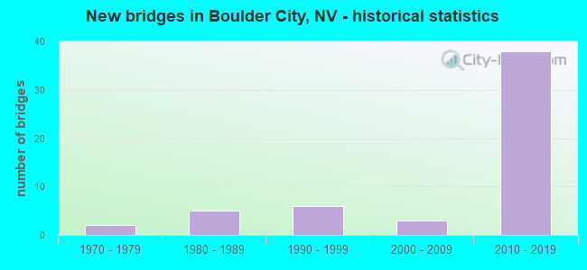
- New bridges - historical statistics
- 21970-1979
- 51980-1989
- 61990-1999
- 32000-2009
- 382010-2019


- Bridge Condition - Deck
- 46.2%Very good
- 46.2%Good
- 7.7%Satisfactory

- Bridge Condition - Superstructure
- 64.3%Very good
- 35.7%Good

- Bridge Condition - Substructure
- 57.1%Very good
- 42.9%Good

- Bridge Condition - Channel
- 3.1%Excellent
- 50.0%Very good
- 25.0%Good
- 21.9%Satisfactory

- Bridge Condition - Culverts
- 85.7%Good
- 9.5%Satisfactory
- 4.8%Poor
Find on map >> Show street view
Structure Number: 305-B1868, Location: Hoover Dam (Lat: 36.015858, Lng: -114.740164), Route carried "on" structure: Spur State highway 172, Year Built: 1990, Status: Open, Structure Length: 19.94m (65.42ft), Average Daily Traffic: 1,300 (year 2012), Truck Traffic: 1%, Average Future Daily Traffic: 1,900 (year 2039), Design Load: HS 20+Mod, Features Intersected: Canyon Relief
Minimum Vertical Clearance: 21.95m (72.01ft), Kilometerpoint: 0.010, Lanes on structure: 2, Owner: Bureau of Reclamation, Approaching Roadway Width: 12.5m (41.0ft), Material/Design: Prestressed concrete continuous, Design/Construction: Segmental Box Girder, Number Of Spans In Main Unit: 2, Number Of Approach Spans: 2, Length of Maximum Span: 80.8m (265.1ft), Curb or Sidewalk Widths: Left: 0.0m, Right: 1.4m (4.6ft), Curb-To-Curb Width: 10.4m (34.1ft), Out-to-Out Width: 13.2m (43.3ft)
Condition: Deck: Good, Superstructure: Good, Substructure: Good, Operating Rating: 97.2 metric tons, Method Used To Determine Operating Rating: Load Factor (LF) rating reported by rating factor (RF) method using MS18 loading, Inventory Rating: 93.3 metric tons, Method Used To Determine Inventory Rating: Load Factor (LF) rating reported by rating factor (RF) method using MS18 loading, Structural Evaluation: Better than present minimum criteria, Deck Geometry: Equal to present minimum criteria, Approach Roadway Alignment: Equal to present desirable criteria, Designated Inspection Frequency: Every 24 months, Inspection Date: December 2021, Deck Structure Type: Concrete Cast-file-Place
Find on map >> Show street view
Structure Number: G254, Location: BOULDER CITY (Lat: 35.968361, Lng: -114.868392), Route carried "under" structure: City street , Year Built: 2000, Structure Length: 0. m, Average Daily Traffic: 2,000 (year 2017), Features Intersected: VETERANS MEMORIAL DR, Facility Carried by Structure: UPRR HENDRSN SPUR
Minimum Vertical Clearance: 4.72m (15.49ft), Kilometerpoint: 0.000, Lanes under structure: 4, Material/Design: Steel, Design/Construction: Girder and Floorbeam System, Length of Maximum Span: 13.7m (44.9ft)
Find on map >> Show street view
Structure Number: H2702, Location: HOOVER DAM RESERVATION (Lat: 36.014694, Lng: -114.755639), Route carried "under" structure: US 93, Year Built: 2010, Structure Length: 0. m, Average Daily Traffic: 13,000 (year 2009), Truck Traffic: 5%, Features Intersected: OLD US 93
Minimum Vertical Clearance: 30+ m (98+ ft), Kilometerpoint: 0.000, Lanes on structure: 4, Lanes under structure: 2, Material/Design: Prestressed concrete continuous, Design/Construction: Box Beam or Girders - Single/Spread, Length of Maximum Span: 53.3m (174.9ft)
Find on map >> Show street view
Structure Number: H2703, Location: LAKE MEAD NAT. REC. AREA (Lat: 36.015400, Lng: -114.751681), Route carried "under" structure: US 93, Year Built: 2010, Structure Length: 0. m, Average Daily Traffic: 13,000 (year 2009), Truck Traffic: 1%, Features Intersected: OLD US 93
Minimum Vertical Clearance: 5.70m (18.70ft), Kilometerpoint: 0.000, Lanes on structure: 4, Lanes under structure: 3, Material/Design: Prestressed concrete, Design/Construction: Box Beam or Girders - Single/Spread, Length of Maximum Span: 45.0m (147.6ft)
Find on map >> Show street view
Structure Number: I2699, Location: LAKE MEAD NAT. RECR. A (Lat: 36.011344, Lng: -114.774208), Route carried "under" structure: Federal lands road , Year Built: 2010, Structure Length: 0. m, Average Daily Traffic: 500 (year 2009), Features Intersected: HOOVER DAM ACCESS ROAD, Facility Carried by Structure: US 93
Minimum Vertical Clearance: 5.00m (16.40ft), Kilometerpoint: 0.000, Lanes on structure: 4, Lanes under structure: 2, Material/Design: Prestressed concrete, Design/Construction: Box Beam or Girders - Single/Spread, Length of Maximum Span: 47.0m (154.2ft)
Find on map >> Show street view
Structure Number: P3175, Location: BOULDER CITY BYPASS (Lat: 35.991944, Lng: -114.799444), Route carried "under" structure: Interstate 11, Year Built: 2018, Structure Length: 0. m, Average Daily Traffic: 41,000 (year 2017), Features Intersected: I-11, Facility Carried by Structure: WILDLIFE OVERPASS
Minimum Vertical Clearance: 30+ m (98+ ft), Kilometerpoint: 6.759, Lanes under structure: 4, Material/Design: Concrete, Design/Construction: Arch - Deck, Length of Maximum Span: 22.9m (75.1ft)