Bridge Statistics for Boulder, Colorado (CO)
Condition, Traffic, Stress, Structural Evaluation, Project Costs
- National Bridge Inventory (NBI) Statistics
- 126Number of bridges
- 958ft / 292mTotal length
- $10,476,000Total costs
- 1,968,611Total average daily traffic
- 80,310Total average daily truck traffic
- National Bridge Inventory (NBI) Registered Bridges for Boulder
- No street view available for this location
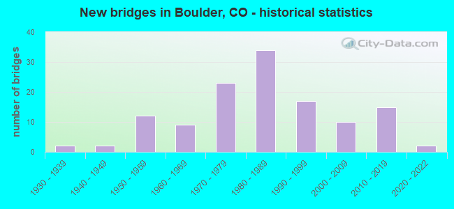
- New bridges - historical statistics
- 21930-1939
- 21940-1949
- 121950-1959
- 91960-1969
- 231970-1979
- 341980-1989
- 171990-1999
- 102000-2009
- 152010-2019
- 22020-2022
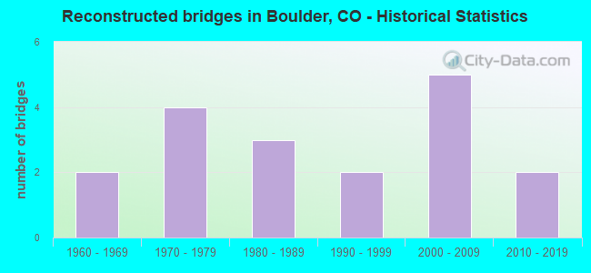
- Reconstructed bridges - Historical Statistics
- 21960-1969
- 41970-1979
- 31980-1989
- 21990-1999
- 52000-2009
- 22010-2019
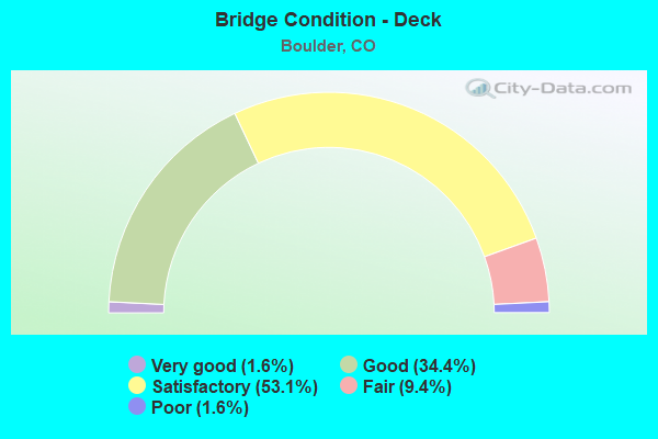
- Bridge Condition - Deck
- 1.6%Very good
- 34.4%Good
- 53.1%Satisfactory
- 9.4%Fair
- 1.6%Poor
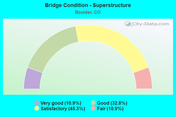
- Bridge Condition - Superstructure
- 10.9%Very good
- 32.8%Good
- 45.3%Satisfactory
- 10.9%Fair
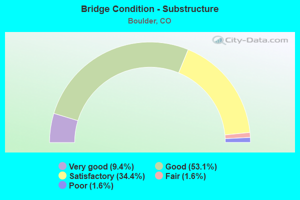
- Bridge Condition - Substructure
- 9.4%Very good
- 53.1%Good
- 34.4%Satisfactory
- 1.6%Fair
- 1.6%Poor
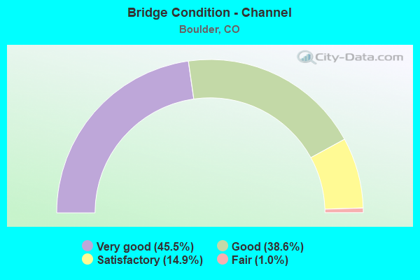
- Bridge Condition - Channel
- 45.5%Very good
- 38.6%Good
- 14.9%Satisfactory
- 1.0%Fair
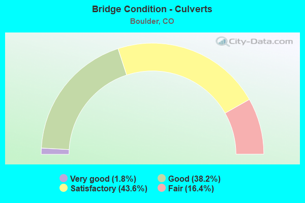
- Bridge Condition - Culverts
- 1.8%Very good
- 38.2%Good
- 43.6%Satisfactory
- 16.4%Fair
Find on map >> Show street view
Structure Number: D-15-BC, Location: N. of Arapahoe Ave (Lat: 40.014658, Lng: -105.278728), Route carried "on" structure: State highway 93A, Year Built: 2004, Status: Open, Structure Length: 6.28m (20.60ft), Average Daily Traffic: 22,000 (year 2020), Truck Traffic: 4%, Average Future Daily Traffic: 23,320 (year 2040), Design Load: HS 25 or greater, Features Intersected: BOULDER CREEK, Facility Carried by Structure: SH 93 ML
Minimum Vertical Clearance: 30+ m (98+ ft), Kilometerpoint: 31.538, Lanes on structure: 4, Base Highway Network: Yes, Owner: State Highway Agency, Approaching Roadway Width: 15.2m (49.9ft), Material/Design: Prestressed concrete continuous, Design/Construction: Tee Beam, Number Of Spans In Main Unit: 3, Length of Maximum Span: 40.2m (131.9ft), Curb or Sidewalk Widths: Left: 4.0m (13.1ft), Right: 4.0m (13.1ft), Curb-To-Curb Width: 15.2m (49.9ft), Out-to-Out Width: 24.4m (80.1ft)
Condition: Deck: Satisfactory, Superstructure: Good, Substructure: Good, Channel: Very good, Operating Rating: 58.0 metric tons, Method Used To Determine Operating Rating: Load Factor (LF), Inventory Rating: 34.8 metric tons, Method Used To Determine Inventory Rating: Load Factor (LF), Structural Evaluation: Better than present minimum criteria, Deck Geometry: High priority of corrective action, Waterway Adequacy: Equal to present desirable criteria, Approach Roadway Alignment: Equal to present desirable criteria, Designated Inspection Frequency: Every 24 months, Inspection Date: June 2021, Deck Structure Type: Concrete Cast-file-Place, Wearing Surface/Protective System: Wearing Surface: Latex Concrete, Deck Protection: Epoxy Coated Reinforcing
Find on map >> Show street view
Structure Number: D-15-BG, Location: BROADWAY AND 16TH ST. (Lat: 40.005983, Lng: -105.272128), Route carried "on" structure: State highway 93A, Year Built: 2013, Status: Open, Structure Length: 0.85m (2.79ft), Average Daily Traffic: 27,000 (year 2020), Truck Traffic: 4%, Average Future Daily Traffic: 29,160 (year 2040), Design Load: HL 93, Features Intersected: PED. UNDERPASS, Facility Carried by Structure: SH 93 ML
Minimum Vertical Clearance: 30.45m (99.90ft), Kilometerpoint: 30.386, Lanes on structure: 6, Base Highway Network: Yes, Owner: State Highway Agency, Approaching Roadway Width: 22.6m (74.1ft), Skew: 30 degrees, Material/Design: Concrete, Design/Construction: Frame, Number Of Spans In Main Unit: 1, Length of Maximum Span: 7.3m (24.0ft), Curb or Sidewalk Widths: Left: 2.6m (8.5ft), Right: 0.2m (0.7ft), Curb-To-Curb Width: 23.2m (76.1ft), Out-to-Out Width: 27.2m (89.2ft)
Condition: Deck: Satisfactory, Superstructure: Satisfactory, Substructure: Good, Operating Rating: 64.8 metric tons, Method Used To Determine Operating Rating: Load and Resistance Factor Rating (LRFR) rating reported by rating factor(RF) method using HL-93 loadings, Inventory Rating: 49.9 metric tons, Method Used To Determine Inventory Rating: Load and Resistance Factor Rating (LRFR) rating reported by rating factor(RF) method using HL-93 loadings, Structural Evaluation: Equal to present minimum criteria, Deck Geometry: Meets minimum limits, Approach Roadway Alignment: Equal to present desirable criteria, Designated Inspection Frequency: Every 24 months, Inspection Date: June 2021, Deck Structure Type: Concrete Cast-file-Place, Wearing Surface/Protective System: Wearing Surface: Bituminous, Membrane: Built-up, Deck Protection: Epoxy Coated Reinforcing
Find on map >> Show street view
Structure Number: D-15-BO, Location: S end of BOULDER (Lat: 40.000653, Lng: -105.258156), Route carried "on" structure: US 36B, Year Built: 1993, Status: Open, Structure Length: 9.57m (31.40ft), Average Daily Traffic: 16,500 (year 2020), Truck Traffic: 3%, Average Future Daily Traffic: 18,150 (year 2040), Design Load: HS 20, Features Intersected: US 36 SPUR/BASELINE RD, Facility Carried by Structure: US 36 WBND SPUR
Minimum Vertical Clearance: 30+ m (98+ ft), Kilometerpoint: 60.492, Lanes on structure: 2, Lanes under structure: 6, Base Highway Network: Yes, Owner: State Highway Agency, Approaching Roadway Width: 14.0m (45.9ft), Skew: 13 degrees, Material/Design: Prestressed concrete, Design/Construction: Box Beam or Girders - Multiple, Number Of Spans In Main Unit: 2, Length of Maximum Span: 47.3m (155.2ft), Curb-To-Curb Width: 14.0m (45.9ft), Out-to-Out Width: 14.9m (48.9ft)
Condition: Deck: Good, Superstructure: Good, Substructure: Good, Operating Rating: 79.5 metric tons, Method Used To Determine Operating Rating: Load Factor (LF), Inventory Rating: 47.7 metric tons, Method Used To Determine Inventory Rating: Load Factor (LF), Structural Evaluation: Better than present minimum criteria, Deck Geometry: Superior to present desirable criteria, Underclear: Superior to present desirable criteria, Approach Roadway Alignment: Equal to present desirable criteria, Designated Inspection Frequency: Every 24 months, Inspection Date: August 2021, Deck Structure Type: Other, Wearing Surface/Protective System: Wearing Surface: Bituminous, Membrane: Preformed Fabric, Deck Protection: Epoxy Coated Reinforcing
Find on map >> Show street view
Structure Number: D-15-BP, Location: BROADWAY AT COLLEGE BLVD (Lat: 40.007567, Lng: -105.275028), Route carried "on" structure: State highway 93A, Year Built: 1992, Status: Open, Structure Length: 0.80m (2.62ft), Average Daily Traffic: 27,000 (year 2020), Truck Traffic: 4%, Average Future Daily Traffic: 29,160 (year 2040), Design Load: HS 20, Features Intersected: PEDESTRIAN UNDERPASS, Facility Carried by Structure: SH 93 ML
Minimum Vertical Clearance: 30+ m (98+ ft), Kilometerpoint: 30.687, Lanes on structure: 4, Base Highway Network: Yes, Owner: State Highway Agency, Approaching Roadway Width: 14.0m (45.9ft), Skew: 31 degrees, Material/Design: Concrete, Design/Construction: Culvert, Number Of Spans In Main Unit: 1, Length of Maximum Span: 8.0m (26.2ft), Curb-To-Curb Width: 14.0m (45.9ft), Out-to-Out Width: 18.7m (61.4ft)
Condition: Culverts: Satisfactory, Operating Rating: 36.3 metric tons, Method Used To Determine Operating Rating: Field evaluation and documented engineering judgment, Inventory Rating: 32.7 metric tons, Method Used To Determine Inventory Rating: Field evaluation and documented engineering judgment, Structural Evaluation: Equal to present minimum criteria, Deck Geometry: High priority of replacement, Approach Roadway Alignment: Equal to present desirable criteria, Length Of Structure Improvement: 0.80m (2.62ft), Designated Inspection Frequency: Every 24 months, Inspection Date: June 2021, Bridge Improvement Cost: $59,000, Roadway Improvement Cost: $6,000, Total Project Cost: $88,000
Find on map >> Show street view
Structure Number: D-15-BR, Location: 28TH ST/WINDING TRAIL DR. (Lat: 40.043608, Lng: -105.258517), Route carried "on" structure: US 36B, Year Built: 2015, Status: Open, Structure Length: 1.05m (3.44ft), Average Daily Traffic: 16,000 (year 2020), Truck Traffic: 2%, Average Future Daily Traffic: 18,240 (year 2040), Design Load: HL 93, Features Intersected: Ped Underpath / Creek, Facility Carried by Structure: US 36 ML
Minimum Vertical Clearance: 30+ m (98+ ft), Kilometerpoint: 55.712, Lanes on structure: 5, Owner: State Highway Agency, Approaching Roadway Width: 20.7m (67.9ft), Material/Design: Concrete, Design/Construction: Culvert, Number Of Spans In Main Unit: 2, Length of Maximum Span: 4.9m (16.1ft), Curb or Sidewalk Widths: Left: 0.0m, Right: 6.9m (22.6ft), Curb-To-Curb Width: 20.7m (67.9ft), Out-to-Out Width: 36.4m (119.4ft)
Condition: Channel: Very good, Culverts: Good, Operating Rating: 43.7 metric tons, Method Used To Determine Operating Rating: Load and Resistance Factor Rating (LRFR) rating reported by rating factor(RF) method using HL-93 loadings, Inventory Rating: 33.7 metric tons, Method Used To Determine Inventory Rating: Load and Resistance Factor Rating (LRFR) rating reported by rating factor(RF) method using HL-93 loadings, Structural Evaluation: Better than present minimum criteria, Deck Geometry: Somewhat better than minimum adequacy, Waterway Adequacy: Equal to present desirable criteria, Approach Roadway Alignment: Equal to present desirable criteria, Designated Inspection Frequency: Every 24 months, Inspection Date: August 2021
Find on map >> Show street view
Structure Number: D-15-CC, Location: 0.1 MI N of 27th WAY (Lat: 39.997919, Lng: -105.261908), Route carried "on" structure: State highway 93A, Year Built: 2014, Status: Open, Structure Length: 0.67m (2.20ft), Average Daily Traffic: 20,000 (year 2020), Truck Traffic: 5%, Average Future Daily Traffic: 21,400 (year 2040), Features Intersected: SKUNK CREEK / PED PATH, Facility Carried by Structure: SH 93 ML
Minimum Vertical Clearance: 30.17m (98.98ft), Kilometerpoint: 29.099, Lanes on structure: 6, Base Highway Network: Yes, Owner: State Highway Agency, Approaching Roadway Width: 21.2m (69.6ft), Skew: 30 degrees, Material/Design: Concrete, Design/Construction: Culvert, Number Of Spans In Main Unit: 1, Length of Maximum Span: 6.7m (22.0ft), Curb or Sidewalk Widths: Left: 3.4m (11.2ft), Right: 0.0m, Curb-To-Curb Width: 21.2m (69.6ft), Out-to-Out Width: 30.2m (99.1ft)
Condition: Channel: Very good, Culverts: Satisfactory, Operating Rating: 36.3 metric tons, Method Used To Determine Operating Rating: Field evaluation and documented engineering judgment, Inventory Rating: 32.7 metric tons, Method Used To Determine Inventory Rating: Field evaluation and documented engineering judgment, Structural Evaluation: Equal to present minimum criteria, Deck Geometry: High priority of replacement, Approach Roadway Alignment: Equal to present desirable criteria, Designated Inspection Frequency: Every 24 months, Inspection Date: June 2021
Find on map >> Show street view
Structure Number: D-15-G, Location: JUST WEST OF BOULDER (Lat: 40.012169, Lng: -105.302556), Route carried "on" structure: State highway 119A, Year Built: 1953, Status: Open, Structure Length: 3.67m (12.04ft), Average Daily Traffic: 6,400 (year 2020), Truck Traffic: 3%, Average Future Daily Traffic: 7,040 (year 2040), Design Load: H 15, Features Intersected: BOULDER CREEK, Facility Carried by Structure: SH 119 ML
Minimum Vertical Clearance: 30+ m (98+ ft), Kilometerpoint: 64.972, Lanes on structure: 2, Base Highway Network: Yes, Owner: State Highway Agency, Approaching Roadway Width: 8.5m (27.9ft), Skew: 4 degrees, Material/Design: Concrete continuous, Design/Construction: Tee Beam, Number Of Spans In Main Unit: 3, Length of Maximum Span: 22.9m (75.1ft), Curb or Sidewalk Widths: Left: 0.0m, Right: 2.6m (8.5ft), Curb-To-Curb Width: 9.1m (29.9ft), Out-to-Out Width: 12.5m (41.0ft)
Condition: Deck: Satisfactory, Superstructure: Satisfactory, Substructure: Good, Channel: Good, Operating Rating: 49.9 metric tons, Method Used To Determine Operating Rating: Load Factor (LF), Inventory Rating: 30.0 metric tons, Method Used To Determine Inventory Rating: Load Factor (LF), Structural Evaluation: Equal to present minimum criteria, Deck Geometry: High priority of corrective action, Waterway Adequacy: Equal to present minimum criteria, Approach Roadway Alignment: Equal to present desirable criteria, Length Of Structure Improvement: 3.69m (12.11ft), Designated Inspection Frequency: Every 24 months, Inspection Date: September 2021, Bridge Improvement Cost: $179,000, Roadway Improvement Cost: $18,000, Total Project Cost: $268,000, Deck Structure Type: Other, Wearing Surface/Protective System: Wearing Surface: Bituminous
Find on map >> Show street view
Structure Number: D-16-C, Location: IN LONGMONT (Lat: 40.146817, Lng: -105.102364), Route carried "on" structure: US 287C, Year Built: 1948, Year Reconstructed: 1970, Status: Open, Structure Length: 1.31m (4.30ft), Average Daily Traffic: 24,000 (year 2020), Truck Traffic: 4%, Average Future Daily Traffic: 30,480 (year 2040), Design Load: H 20, Features Intersected: LEFT HAND CREEK, Facility Carried by Structure: US 287 ML
Minimum Vertical Clearance: 30+ m (98+ ft), Kilometerpoint: 50.809, Lanes on structure: 6, Base Highway Network: Yes, Owner: State Highway Agency, Approaching Roadway Width: 26.8m (87.9ft), Skew: 3 degrees, Material/Design: Steel, Design/Construction: Stringer/Multi-beam, Number Of Spans In Main Unit: 1, Length of Maximum Span: 11.9m (39.0ft), Curb-To-Curb Width: 26.8m (87.9ft), Out-to-Out Width: 27.6m (90.6ft)
Condition: Deck: Satisfactory, Superstructure: Good, Substructure: Good, Channel: Satisfactory, Operating Rating: 37.6 metric tons, Method Used To Determine Operating Rating: Load Factor (LF), Inventory Rating: 22.6 metric tons, Method Used To Determine Inventory Rating: Load Factor (LF), Structural Evaluation: Somewhat better than minimum adequacy, Deck Geometry: Better than present minimum criteria, Waterway Adequacy: Equal to present desirable criteria, Approach Roadway Alignment: Equal to present desirable criteria, Designated Inspection Frequency: Every 24 months, Inspection Date: August 2021, Deck Structure Type: Concrete Cast-file-Place, Wearing Surface/Protective System: Wearing Surface: Bituminous
Find on map >> Show street view
Structure Number: D-16-CF, Location: @ 55TH ST NE OF BOULDER (Lat: 40.058308, Lng: -105.225292), Route carried "on" structure: State highway 119B, Year Built: 1971, Status: Open, Structure Length: 0.63m (2.07ft), Average Daily Traffic: 22,000 (year 2020), Truck Traffic: 3%, Average Future Daily Traffic: 25,520 (year 2040), Design Load: HS 20, Features Intersected: BEASLEY DITCH, Facility Carried by Structure: SH 119 ML SBND
Minimum Vertical Clearance: 30+ m (98+ ft), Kilometerpoint: 3.924, Lanes on structure: 4, Base Highway Network: Yes, Owner: State Highway Agency, Approaching Roadway Width: 11.6m (38.1ft), Skew: 4 degrees, Material/Design: Concrete, Design/Construction: Culvert, Number Of Spans In Main Unit: 1, Length of Maximum Span: 6.3m (20.7ft), Out-to-Out Width: 30.6m (100.4ft)
Condition: Channel: Good, Culverts: Good, Operating Rating: 36.3 metric tons, Method Used To Determine Operating Rating: Field evaluation and documented engineering judgment, Inventory Rating: 32.7 metric tons, Method Used To Determine Inventory Rating: Field evaluation and documented engineering judgment, Structural Evaluation: Better than present minimum criteria, Waterway Adequacy: Equal to present desirable criteria, Approach Roadway Alignment: Equal to present desirable criteria, Designated Inspection Frequency: Every 24 months, Inspection Date: April 2021
Find on map >> Show street view
Structure Number: D-16-CN, Location: 0.03 MI N OF PEARL ST (Lat: 40.045744, Lng: -105.411711), Route carried "on" structure: State highway 157A, Year Built: 1986, Status: Open, Structure Length: 1.35m (4.43ft), Average Daily Traffic: 42,000 (year 2020), Truck Traffic: 3%, Average Future Daily Traffic: 44,940 (year 2040), Design Load: HS 20, Features Intersected: SOUTH GOOSE CREEK, Facility Carried by Structure: SH 157 ML
Minimum Vertical Clearance: 30+ m (98+ ft), Kilometerpoint: 4.884, Lanes on structure: 6, Base Highway Network: Yes, Owner: State Highway Agency, Approaching Roadway Width: 26.2m (86.0ft), Skew: 23 degrees, Material/Design: Concrete, Design/Construction: Culvert, Number Of Spans In Main Unit: 4, Length of Maximum Span: 3.1m (10.2ft), Out-to-Out Width: 75.7m (248.4ft)
Condition: Channel: Good, Culverts: Fair, Operating Rating: 89.8 metric tons, Method Used To Determine Operating Rating: Field evaluation and documented engineering judgment, Inventory Rating: 89.8 metric tons, Method Used To Determine Inventory Rating: Field evaluation and documented engineering judgment, Structural Evaluation: Somewhat better than minimum adequacy, Waterway Adequacy: Equal to present desirable criteria, Approach Roadway Alignment: Equal to present desirable criteria, Designated Inspection Frequency: Every 24 months, Inspection Date: August 2021
Find on map >> Show street view
Structure Number: D-16-CR, Location: NEAR COLORADO AVE. (Lat: 40.008031, Lng: -105.239036), Route carried "on" structure: State highway 157A, Year Built: 1978, Status: Open, Structure Length: 1.43m (4.69ft), Average Daily Traffic: 38,000 (year 2020), Truck Traffic: 5%, Average Future Daily Traffic: 39,140 (year 2040), Design Load: HS 20, Features Intersected: BEAR CANYON CREEK, Facility Carried by Structure: SH 157 ML
Minimum Vertical Clearance: 30+ m (98+ ft), Kilometerpoint: 3.092, Lanes on structure: 5, Base Highway Network: Yes, Owner: State Highway Agency, Approaching Roadway Width: 26.5m (86.9ft), Skew: 22 degrees, Material/Design: Concrete, Design/Construction: Culvert, Number Of Spans In Main Unit: 3, Length of Maximum Span: 5.2m (17.1ft), Curb or Sidewalk Widths: Left: 0.0m, Right: 3.0m (9.8ft), Out-to-Out Width: 38.1m (125.0ft)
Condition: Channel: Good, Culverts: Fair, Operating Rating: 36.3 metric tons, Method Used To Determine Operating Rating: Load Factor (LF), Inventory Rating: 32.7 metric tons, Method Used To Determine Inventory Rating: Load Factor (LF), Structural Evaluation: Somewhat better than minimum adequacy, Waterway Adequacy: Equal to present minimum criteria, Approach Roadway Alignment: Equal to present desirable criteria, Designated Inspection Frequency: Every 24 months, Inspection Date: August 2021
Find on map >> Show street view
Structure Number: D-16-CS, Location: IN BOULDER (Lat: 40.012378, Lng: -105.240150), Route carried "on" structure: State highway 157A, Year Built: 1978, Status: Open, Structure Length: 0.87m (2.85ft), Average Daily Traffic: 43,000 (year 2020), Truck Traffic: 4%, Average Future Daily Traffic: 46,440 (year 2040), Design Load: HS 20, Features Intersected: SKUNK CREEK, Facility Carried by Structure: SH 157 ML
Minimum Vertical Clearance: 30+ m (98+ ft), Kilometerpoint: 3.602, Lanes on structure: 5, Base Highway Network: Yes, Owner: State Highway Agency, Approaching Roadway Width: 24.5m (80.4ft), Skew: 23 degrees, Material/Design: Concrete, Design/Construction: Culvert, Number Of Spans In Main Unit: 2, Length of Maximum Span: 4.2m (13.8ft), Curb or Sidewalk Widths: Left: 0.0m, Right: 3.7m (12.1ft), Out-to-Out Width: 41.7m (136.8ft)
Condition: Channel: Good, Culverts: Satisfactory, Operating Rating: 36.3 metric tons, Method Used To Determine Operating Rating: Field evaluation and documented engineering judgment, Inventory Rating: 32.7 metric tons, Method Used To Determine Inventory Rating: Field evaluation and documented engineering judgment, Structural Evaluation: Equal to present minimum criteria, Waterway Adequacy: Equal to present minimum criteria, Approach Roadway Alignment: Equal to present desirable criteria, Designated Inspection Frequency: Every 24 months, Inspection Date: August 2021
Find on map >> Show street view
Structure Number: D-16-CU, Location: 2.9 MI N OF US 36 (Lat: 40.022683, Lng: -105.244689), Route carried "on" structure: State highway 157A, Year Built: 1985, Status: Open, Structure Length: 4.69m (15.39ft), Average Daily Traffic: 43,000 (year 2020), Truck Traffic: 4%, Average Future Daily Traffic: 46,440 (year 2040), Design Load: HS 20+Mod, Features Intersected: PEARL STREET, Facility Carried by Structure: SH 157 ML
Minimum Vertical Clearance: 5.28m (17.32ft), Kilometerpoint: 4.823, Lanes on structure: 4, Lanes under structure: 4, Base Highway Network: Yes, Owner: State Highway Agency, Approaching Roadway Width: 21.3m (69.9ft), Skew: 10 degrees, Material/Design: Prestressed concrete, Design/Construction: Stringer/Multi-beam, Number Of Spans In Main Unit: 1, Length of Maximum Span: 45.7m (149.9ft), Curb-To-Curb Width: 21.3m (69.9ft), Out-to-Out Width: 26.4m (86.6ft)
Condition: Deck: Good, Superstructure: Satisfactory, Substructure: Satisfactory, Operating Rating: 69.5 metric tons, Method Used To Determine Operating Rating: Load Factor (LF), Inventory Rating: 8.2 metric tons, Method Used To Determine Inventory Rating: Load Factor (LF), Structural Evaluation: High priority of corrective action, Deck Geometry: Better than present minimum criteria, Underclear: Equal to present minimum criteria, Approach Roadway Alignment: Equal to present desirable criteria, Designated Inspection Frequency: Every 24 months, Inspection Date: August 2021, Deck Structure Type: Concrete Cast-file-Place, Wearing Surface/Protective System: Wearing Surface: Bituminous, Membrane: Preformed Fabric, Deck Protection: Epoxy Coated Reinforcing
Find on map >> Show street view
Structure Number: D-16-CV, Location: IN BOULDER (Lat: 40.020336, Lng: -105.244128), Route carried "on" structure: State highway 157A, Year Built: 1981, Status: Open, Structure Length: 5.65m (18.54ft), Average Daily Traffic: 43,000 (year 2020), Truck Traffic: 4%, Average Future Daily Traffic: 46,440 (year 2040), Design Load: HS 20+Mod, Features Intersected: BNSF RR, Facility Carried by Structure: SH 157 ML
Minimum Vertical Clearance: 7.21m (23.65ft), Kilometerpoint: 4.556, Lanes on structure: 6, Base Highway Network: Yes, Owner: State Highway Agency, Approaching Roadway Width: 26.8m (87.9ft), Skew: 23 degrees, Material/Design: Prestressed concrete continuous, Design/Construction: Box Beam or Girders - Single/Spread, Number Of Spans In Main Unit: 3, Length of Maximum Span: 23.6m (77.4ft), Curb or Sidewalk Widths: Left: 0.0m, Right: 3.0m (9.8ft), Curb-To-Curb Width: 31.1m (102.0ft), Out-to-Out Width: 35.1m (115.2ft)
Condition: Deck: Satisfactory, Superstructure: Good, Substructure: Good, Operating Rating: 35.6 metric tons, Method Used To Determine Operating Rating: Load Factor (LF), Inventory Rating: 10.9 metric tons, Method Used To Determine Inventory Rating: Load Factor (LF), Structural Evaluation: High priority of corrective action, Deck Geometry: Superior to present desirable criteria, Underclear: Equal to present minimum criteria, Approach Roadway Alignment: Equal to present desirable criteria, Length Of Structure Improvement: 5.65m (18.54ft), Designated Inspection Frequency: Every 24 months, Inspection Date: August 2021, Bridge Improvement Cost: $1,459,000, Roadway Improvement Cost: $146,000, Total Project Cost: $1,605,000 ( Estimate for 2017), Deck Structure Type: Concrete Cast-file-Place, Wearing Surface/Protective System: Wearing Surface: Bituminous, Membrane: Preformed Fabric
Find on map >> Show street view
Structure Number: D-16-CW, Location: JUST N. OF HWY 7 (Lat: 40.015883, Lng: -105.241353), Route carried "on" structure: State highway 157A, Year Built: 1981, Status: Open, Structure Length: 11.20m (36.75ft), Average Daily Traffic: 43,000 (year 2020), Truck Traffic: 4%, Average Future Daily Traffic: 46,440 (year 2040), Design Load: HS 20, Features Intersected: BOULDER CREEK, Facility Carried by Structure: SH 157 ML
Minimum Vertical Clearance: 30+ m (98+ ft), Kilometerpoint: 4.006, Lanes on structure: 6, Base Highway Network: Yes, Owner: State Highway Agency, Approaching Roadway Width: 24.5m (80.4ft), Skew: 32 degrees, Material/Design: Prestressed concrete continuous, Design/Construction: Stringer/Multi-beam, Number Of Spans In Main Unit: 4, Length of Maximum Span: 31.7m (104.0ft), Curb-To-Curb Width: 24.5m (80.4ft), Out-to-Out Width: 26.4m (86.6ft)
Condition: Deck: Satisfactory, Superstructure: Good, Substructure: Satisfactory, Channel: Very good, Operating Rating: 64.6 metric tons, Method Used To Determine Operating Rating: Load Factor (LF), Inventory Rating: 35.8 metric tons, Method Used To Determine Inventory Rating: Load Factor (LF), Structural Evaluation: Equal to present minimum criteria, Deck Geometry: Meets minimum limits, Waterway Adequacy: Equal to present desirable criteria, Approach Roadway Alignment: Equal to present desirable criteria, Designated Inspection Frequency: Every 24 months, Inspection Date: August 2021, Deck Structure Type: Concrete Cast-file-Place, Wearing Surface/Protective System: Wearing Surface: Bituminous, Membrane: Preformed Fabric
Find on map >> Show street view
Structure Number: D-16-CX, Location: IN BOULDER (Lat: 40.019386, Lng: -105.243647), Route carried "on" structure: State highway 157A, Year Built: 1981, Status: Open, Structure Length: 4.63m (15.19ft), Average Daily Traffic: 43,000 (year 2020), Truck Traffic: 4%, Average Future Daily Traffic: 46,440 (year 2040), Design Load: HS 20+Mod, Features Intersected: WALNUT STREET, Facility Carried by Structure: SH 157 ML
Minimum Vertical Clearance: 6.78m (22.24ft), Kilometerpoint: 4.440, Lanes on structure: 6, Lanes under structure: 2, Base Highway Network: Yes, Owner: State Highway Agency, Approaching Roadway Width: 26.8m (87.9ft), Skew: 20 degrees, Material/Design: Concrete continuous, Design/Construction: Tee Beam, Number Of Spans In Main Unit: 3, Length of Maximum Span: 20.3m (66.6ft), Curb or Sidewalk Widths: Left: 0.0m, Right: 3.0m (9.8ft), Curb-To-Curb Width: 31.1m (102.0ft), Out-to-Out Width: 35.1m (115.2ft)
Condition: Deck: Satisfactory, Superstructure: Good, Substructure: Good, Operating Rating: 68.3 metric tons, Method Used To Determine Operating Rating: Load Factor (LF), Inventory Rating: 40.9 metric tons, Method Used To Determine Inventory Rating: Load Factor (LF), Structural Evaluation: Better than present minimum criteria, Deck Geometry: Superior to present desirable criteria, Underclear: Superior to present desirable criteria, Approach Roadway Alignment: Equal to present desirable criteria, Designated Inspection Frequency: Every 24 months, Inspection Date: August 2021, Deck Structure Type: Concrete Cast-file-Place, Wearing Surface/Protective System: Wearing Surface: Bituminous, Membrane: Preformed Fabric
Find on map >> Show street view
Structure Number: D-16-CZ, Location: 0.05 MI N OF PEARL ST. (Lat: 40.025503, Lng: -105.244619), Route carried "on" structure: State highway 157A, Year Built: 1986, Status: Open, Structure Length: 1.90m (6.23ft), Average Daily Traffic: 42,000 (year 2020), Truck Traffic: 3%, Average Future Daily Traffic: 44,940 (year 2040), Design Load: HS 20, Features Intersected: NORTH GOOSE CREEK, Facility Carried by Structure: SH 157 ML
Minimum Vertical Clearance: 30+ m (98+ ft), Kilometerpoint: 5.135, Lanes on structure: 6, Base Highway Network: Yes, Owner: State Highway Agency, Approaching Roadway Width: 26.2m (86.0ft), Skew: 20 degrees, Material/Design: Concrete, Design/Construction: Culvert, Number Of Spans In Main Unit: 7, Length of Maximum Span: 2.4m (7.9ft), Out-to-Out Width: 94.5m (310.0ft)
Condition: Channel: Good, Culverts: Satisfactory, Operating Rating: 89.8 metric tons, Method Used To Determine Operating Rating: Field evaluation and documented engineering judgment, Inventory Rating: 89.8 metric tons, Method Used To Determine Inventory Rating: Field evaluation and documented engineering judgment, Structural Evaluation: Equal to present minimum criteria, Waterway Adequacy: Equal to present desirable criteria, Approach Roadway Alignment: Equal to present desirable criteria, Designated Inspection Frequency: Every 24 months, Inspection Date: July 2021
Find on map >> Show street view
Structure Number: D-16-D, Location: Ken Pratt Blvd-Longmont (Lat: 40.152236, Lng: -105.103428), Route carried "on" structure: US 287C, Year Built: 1947, Year Reconstructed: 1970, Status: Open, Structure Length: 0.64m (2.10ft), Average Daily Traffic: 22,000 (year 2020), Truck Traffic: 5%, Average Future Daily Traffic: 25,300 (year 2040), Design Load: H 20, Features Intersected: DRY CREEK, Facility Carried by Structure: US 287 ML
Minimum Vertical Clearance: 30+ m (98+ ft), Kilometerpoint: 19.191, Lanes on structure: 12, Base Highway Network: Yes, Owner: State Highway Agency, Approaching Roadway Width: 27.1m (88.9ft), Skew: 9 degrees, Material/Design: Concrete, Design/Construction: Culvert, Number Of Spans In Main Unit: 2, Length of Maximum Span: 3.0m (9.8ft), Curb or Sidewalk Widths: Left: 2.4m (7.9ft), Right: 2.4m (7.9ft), Out-to-Out Width: 105.2m (345.1ft)
Condition: Channel: Good, Culverts: Satisfactory, Operating Rating: 36.3 metric tons, Method Used To Determine Operating Rating: Field evaluation and documented engineering judgment, Inventory Rating: 32.7 metric tons, Method Used To Determine Inventory Rating: Field evaluation and documented engineering judgment, Structural Evaluation: Equal to present minimum criteria, Waterway Adequacy: Equal to present desirable criteria, Approach Roadway Alignment: Equal to present desirable criteria, Designated Inspection Frequency: Every 24 months, Inspection Date: August 2021
Find on map >> Show street view
Structure Number: D-16-DB, Location: JCT 157 & ARAPAHOE (Lat: 40.014922, Lng: -105.239536), Route carried "on" structure: State highway 7C, Year Built: 1985, Status: Open, Structure Length: 2.63m (8.63ft), Average Daily Traffic: 29,000 (year 2020), Truck Traffic: 3%, Average Future Daily Traffic: 32,770 (year 2040), Design Load: HS 20, Features Intersected: BEAR CANYON CREEK, Facility Carried by Structure: SH 7 ML
Minimum Vertical Clearance: 30+ m (98+ ft), Kilometerpoint: 1.630, Lanes on structure: 11, Base Highway Network: Yes, Owner: State Highway Agency, Approaching Roadway Width: 41.0m (134.5ft), Skew: 30 degrees, Material/Design: Concrete, Design/Construction: Culvert, Number Of Spans In Main Unit: 7, Length of Maximum Span: 4.3m (14.1ft), Curb or Sidewalk Widths: Left: 3.9m (12.8ft), Right: 3.8m (12.5ft), Curb-To-Curb Width: 41.0m (134.5ft), Out-to-Out Width: 50.7m (166.3ft)
Condition: Channel: Very good, Culverts: Fair, Operating Rating: 36.3 metric tons, Method Used To Determine Operating Rating: Field evaluation and documented engineering judgment, Inventory Rating: 32.7 metric tons, Method Used To Determine Inventory Rating: Field evaluation and documented engineering judgment, Structural Evaluation: Somewhat better than minimum adequacy, Deck Geometry: Somewhat better than minimum adequacy, Waterway Adequacy: Equal to present desirable criteria, Approach Roadway Alignment: Equal to present desirable criteria, Designated Inspection Frequency: Every 24 months, Inspection Date: July 2021
Find on map >> Show street view
Structure Number: D-16-DD, Location: IN BOULDER (Lat: 40.033075, Lng: -105.244017), Route carried "on" structure: State highway 157A, Year Built: 1987, Year Reconstructed: 2005, Status: Open, Structure Length: 1.78m (5.84ft), Average Daily Traffic: 34,000 (year 2020), Truck Traffic: 3%, Average Future Daily Traffic: 36,720 (year 2040), Design Load: HS 20, Features Intersected: WONDERLAND CREEK, Facility Carried by Structure: SH 157 ML
Minimum Vertical Clearance: 30+ m (98+ ft), Kilometerpoint: 5.975, Lanes on structure: 6, Base Highway Network: Yes, Owner: State Highway Agency, Approaching Roadway Width: 35.1m (115.2ft), Skew: 4 degrees, Material/Design: Concrete, Design/Construction: Culvert, Number Of Spans In Main Unit: 3, Length of Maximum Span: 5.7m (18.7ft), Out-to-Out Width: 98.8m (324.1ft)
Condition: Channel: Good, Culverts: Satisfactory, Operating Rating: 89.8 metric tons, Method Used To Determine Operating Rating: Field evaluation and documented engineering judgment, Inventory Rating: 89.8 metric tons, Method Used To Determine Inventory Rating: Field evaluation and documented engineering judgment, Structural Evaluation: Equal to present minimum criteria, Waterway Adequacy: Equal to present desirable criteria, Approach Roadway Alignment: Equal to present desirable criteria, Designated Inspection Frequency: Every 24 months, Inspection Date: August 2021
Find on map >> Show street view
Structure Number: D-16-DE, Location: IN BOULDER (Lat: 40.033733, Lng: -105.244308), Route carried "on" structure: State highway 157A, Year Built: 1987, Year Reconstructed: 2005, Status: Open, Structure Length: 0.64m (2.10ft), Average Daily Traffic: 34,000 (year 2020), Truck Traffic: 3%, Average Future Daily Traffic: 36,720 (year 2040), Design Load: HS 20, Features Intersected: BOULDER, WHITEROCK DITCH, Facility Carried by Structure: SH 157 ML
Minimum Vertical Clearance: 30+ m (98+ ft), Kilometerpoint: 6.046, Lanes on structure: 7, Base Highway Network: Yes, Owner: State Highway Agency, Approaching Roadway Width: 35.1m (115.2ft), Skew: 3 degrees, Material/Design: Concrete, Design/Construction: Culvert, Number Of Spans In Main Unit: 2, Length of Maximum Span: 3.0m (9.8ft), Out-to-Out Width: 93.6m (307.1ft)
Condition: Channel: Satisfactory, Culverts: Satisfactory, Operating Rating: 89.8 metric tons, Method Used To Determine Operating Rating: Field evaluation and documented engineering judgment, Inventory Rating: 89.8 metric tons, Method Used To Determine Inventory Rating: Field evaluation and documented engineering judgment, Structural Evaluation: Equal to present minimum criteria, Waterway Adequacy: Equal to present desirable criteria, Approach Roadway Alignment: Equal to present desirable criteria, Designated Inspection Frequency: Every 24 months, Inspection Date: August 2021
Find on map >> Show street view
Structure Number: D-16-DF, Location: IN BOULDER (Lat: 40.038011, Lng: -105.244692), Route carried "on" structure: State highway 157A, Year Built: 1988, Status: Open, Structure Length: 6.05m (19.85ft), Average Daily Traffic: 34,000 (year 2020), Truck Traffic: 3%, Average Future Daily Traffic: 36,720 (year 2040), Design Load: HS 20+Mod, Features Intersected: SH 119 ML, Facility Carried by Structure: SH 157 ML
Minimum Vertical Clearance: 5.84m (19.16ft), Kilometerpoint: 6.521, Lanes on structure: 4, Lanes under structure: 7, Base Highway Network: Yes, Owner: State Highway Agency, Approaching Roadway Width: 21.3m (69.9ft), Skew: 22 degrees, Material/Design: Prestressed concrete continuous, Design/Construction: Stringer/Multi-beam, Number Of Spans In Main Unit: 2, Length of Maximum Span: 31.2m (102.4ft), Curb-To-Curb Width: 21.3m (69.9ft), Out-to-Out Width: 26.4m (86.6ft)
Condition: Deck: Satisfactory, Superstructure: Good, Substructure: Satisfactory, Operating Rating: 62.0 metric tons, Method Used To Determine Operating Rating: Load Factor (LF), Inventory Rating: 36.5 metric tons, Method Used To Determine Inventory Rating: Load Factor (LF), Structural Evaluation: Equal to present minimum criteria, Deck Geometry: Better than present minimum criteria, Underclear: High priority of corrective action, Approach Roadway Alignment: Equal to present desirable criteria, Designated Inspection Frequency: Every 24 months, Inspection Date: August 2021, Deck Structure Type: Concrete Cast-file-Place, Wearing Surface/Protective System: Wearing Surface: Epoxy Overlay, Membrane: Other, Deck Protection: Epoxy Coated Reinforcing
Find on map >> Show street view
Structure Number: D-16-DG, Location: IN BOULDER (Lat: 40.035156, Lng: -105.244689), Route carried "on" structure: State highway 157A, Year Built: 1988, Status: Open, Structure Length: 10.35m (33.96ft), Average Daily Traffic: 34,000 (year 2020), Truck Traffic: 3%, Average Future Daily Traffic: 36,720 (year 2040), Design Load: HS 20, Features Intersected: BNSF RR, Facility Carried by Structure: SH 157 ML
Minimum Vertical Clearance: 30+ m (98+ ft), Kilometerpoint: 6.204, Lanes on structure: 5, Base Highway Network: Yes, Owner: State Highway Agency, Approaching Roadway Width: 24.4m (80.1ft), Skew: 26 degrees, Material/Design: Prestressed concrete continuous, Design/Construction: Stringer/Multi-beam, Number Of Spans In Main Unit: 3, Length of Maximum Span: 36.9m (121.1ft), Curb-To-Curb Width: 28.7m (94.2ft), Out-to-Out Width: 29.4m (96.5ft)
Condition: Deck: Satisfactory, Superstructure: Satisfactory, Substructure: Satisfactory, Operating Rating: 44.3 metric tons, Method Used To Determine Operating Rating: Load Factor (LF), Inventory Rating: 26.5 metric tons, Method Used To Determine Inventory Rating: Load Factor (LF), Structural Evaluation: Equal to present minimum criteria, Deck Geometry: Superior to present desirable criteria, Underclear: Somewhat better than minimum adequacy, Approach Roadway Alignment: Equal to present desirable criteria, Designated Inspection Frequency: Every 24 months, Inspection Date: August 2021, Deck Structure Type: Concrete Cast-file-Place, Wearing Surface/Protective System: Wearing Surface: Monolithic Concrete
Find on map >> Show street view
Structure Number: D-16-DJ, Location: TWO MILES N OF BOULDER CI (Lat: 40.045419, Lng: -105.240231), Route carried "on" structure: State highway 157A, Year Built: 1988, Status: Open, Structure Length: 4.03m (13.22ft), Average Daily Traffic: 20,500 (year 2020), Truck Traffic: 3%, Average Future Daily Traffic: 22,550 (year 2040), Design Load: HS 20, Features Intersected: FOUR MILE CANYON CREEK, Facility Carried by Structure: SH 157 NBND
Minimum Vertical Clearance: 30+ m (98+ ft), Kilometerpoint: 7.490, Lanes on structure: 2, Base Highway Network: Yes, Owner: State Highway Agency, Approaching Roadway Width: 11.6m (38.1ft), Skew: 14 degrees, Material/Design: Prestressed concrete continuous, Design/Construction: Box Beam or Girders - Single/Spread, Number Of Spans In Main Unit: 2, Length of Maximum Span: 19.6m (64.3ft), Curb-To-Curb Width: 11.6m (38.1ft), Out-to-Out Width: 12.3m (40.4ft)
Condition: Deck: Good, Superstructure: Good, Substructure: Good, Channel: Very good, Operating Rating: 61.4 metric tons, Method Used To Determine Operating Rating: Load Factor (LF), Inventory Rating: 38.3 metric tons, Method Used To Determine Inventory Rating: Load Factor (LF), Structural Evaluation: Better than present minimum criteria, Deck Geometry: Equal to present minimum criteria, Waterway Adequacy: Equal to present desirable criteria, Approach Roadway Alignment: Equal to present desirable criteria, Designated Inspection Frequency: Every 24 months, Inspection Date: July 2021, Deck Structure Type: Concrete Cast-file-Place, Wearing Surface/Protective System: Wearing Surface: Epoxy Overlay, Membrane: Other, Deck Protection: Epoxy Coated Reinforcing
Find on map >> Show street view
Structure Number: D-16-DK, Location: .25 MI S OF SH119 INTSN (Lat: 40.045414, Lng: -105.240572), Route carried "on" structure: State highway 157A, Year Built: 1988, Status: Open, Structure Length: 4.03m (13.22ft), Average Daily Traffic: 20,500 (year 2020), Truck Traffic: 3%, Average Future Daily Traffic: 22,550 (year 2040), Design Load: HS 20, Features Intersected: FOUR MILE CANYON CREEK, Facility Carried by Structure: SH 157 SBND
Minimum Vertical Clearance: 30+ m (98+ ft), Kilometerpoint: 7.469, Lanes on structure: 3, Base Highway Network: Yes, Owner: State Highway Agency, Approaching Roadway Width: 14.0m (45.9ft), Skew: 14 degrees, Material/Design: Prestressed concrete continuous, Design/Construction: Box Beam or Girders - Single/Spread, Number Of Spans In Main Unit: 2, Length of Maximum Span: 19.6m (64.3ft), Curb-To-Curb Width: 14.0m (45.9ft), Out-to-Out Width: 14.8m (48.6ft)
Condition: Deck: Good, Superstructure: Good, Substructure: Good, Channel: Very good, Operating Rating: 56.2 metric tons, Method Used To Determine Operating Rating: Load Factor (LF), Inventory Rating: 35.1 metric tons, Method Used To Determine Inventory Rating: Load Factor (LF), Structural Evaluation: Better than present minimum criteria, Deck Geometry: Meets minimum limits, Waterway Adequacy: Equal to present desirable criteria, Approach Roadway Alignment: Equal to present desirable criteria, Designated Inspection Frequency: Every 24 months, Inspection Date: July 2021, Deck Structure Type: Concrete Cast-file-Place, Wearing Surface/Protective System: Wearing Surface: Epoxy Overlay, Membrane: Other, Deck Protection: Epoxy Coated Reinforcing
Find on map >> Show street view
Structure Number: D-16-DL, Location: NEAR SH 119 IN BOULDER (Lat: 40.041878, Lng: -105.244158), Route carried "on" structure: City street , Year Built: 1989, Status: Open, Structure Length: 11.88m (38.98ft), Average Daily Traffic: 4,627 (year 2020), Truck Traffic: 6%, Average Future Daily Traffic: 7,214 (year 2028), Design Load: HS 20, Features Intersected: SH 157 ML, Facility Carried by Structure: 47TH STREET
Minimum Vertical Clearance: 5.82m (19.09ft), Kilometerpoint: 2.245, Lanes on structure: 2, Lanes under structure: 5, Owner: State Highway Agency, Approaching Roadway Width: 11.3m (37.1ft), Skew: 5 degrees, Material/Design: Prestressed concrete continuous, Design/Construction: Stringer/Multi-beam, Number Of Spans In Main Unit: 4, Length of Maximum Span: 36.3m (119.1ft), Curb or Sidewalk Widths: Left: 0.0m, Right: 1.5m (4.9ft), Curb-To-Curb Width: 11.3m (37.1ft), Out-to-Out Width: 13.7m (44.9ft)
Condition: Deck: Good, Superstructure: Good, Substructure: Satisfactory, Operating Rating: 50.7 metric tons, Method Used To Determine Operating Rating: Load Factor (LF), Inventory Rating: 30.4 metric tons, Method Used To Determine Inventory Rating: Load Factor (LF), Structural Evaluation: Equal to present minimum criteria, Deck Geometry: Somewhat better than minimum adequacy, Underclear: High priority of corrective action, Approach Roadway Alignment: Equal to present desirable criteria, Designated Inspection Frequency: Every 24 months, Inspection Date: August 2021, Deck Structure Type: Concrete Cast-file-Place, Wearing Surface/Protective System: Wearing Surface: Bituminous, Membrane: Preformed Fabric, Deck Protection: Epoxy Coated Reinforcing
Find on map >> Show street view
Structure Number: D-16-DQ, Location: EAST OF JCT SH 7 & SH (Lat: 40.014897, Lng: -105.240183), Route carried "on" structure: State highway 7C, Year Built: 2006, Status: Open, Structure Length: 0.67m (2.20ft), Average Daily Traffic: 29,000 (year 2020), Truck Traffic: 3%, Average Future Daily Traffic: 32,770 (year 2040), Design Load: HS 20, Features Intersected: BIKE/PED UNDERPASS, Facility Carried by Structure: SH 7 (ARAPAHOE)
Minimum Vertical Clearance: 30+ m (98+ ft), Kilometerpoint: 1.574, Lanes on structure: 11, Base Highway Network: Yes, Owner: State Highway Agency, Approaching Roadway Width: 41.3m (135.5ft), Skew: 30 degrees, Material/Design: Concrete, Design/Construction: Frame, Number Of Spans In Main Unit: 1, Length of Maximum Span: 6.1m (20.0ft), Curb or Sidewalk Widths: Left: 4.1m (13.5ft), Right: 4.7m (15.4ft), Curb-To-Curb Width: 41.3m (135.5ft), Out-to-Out Width: 51.8m (169.9ft)
Condition: Deck: Satisfactory, Superstructure: Satisfactory, Substructure: Satisfactory, Operating Rating: 81.6 metric tons, Method Used To Determine Operating Rating: Load Factor (LF), Inventory Rating: 58.0 metric tons, Method Used To Determine Inventory Rating: Load Factor (LF), Structural Evaluation: Equal to present minimum criteria, Deck Geometry: Somewhat better than minimum adequacy, Approach Roadway Alignment: Equal to present desirable criteria, Designated Inspection Frequency: Every 24 months, Inspection Date: July 2021, Deck Structure Type: Concrete Cast-file-Place, Wearing Surface/Protective System: Wearing Surface: Monolithic Concrete
Find on map >> Show street view
Structure Number: D-16-I, Location: IN BOULDER (Lat: 40.045481, Lng: -105.239017), Route carried "on" structure: State highway 119B, Year Built: 1958, Year Reconstructed: 1971, Status: Open, Structure Length: 3.32m (10.89ft), Average Daily Traffic: 4,800 (year 2020), Truck Traffic: 4%, Average Future Daily Traffic: 5,040 (year 2040), Design Load: HS 20, Features Intersected: FOUR MILE CREEK, Facility Carried by Structure: SH 119 N/EBND
Minimum Vertical Clearance: 30+ m (98+ ft), Kilometerpoint: 2.166, Lanes on structure: 2, Base Highway Network: Yes, Owner: State Highway Agency, Approaching Roadway Width: 18.3m (60.0ft), Skew: 2 degrees, Material/Design: Concrete, Design/Construction: Tee Beam, Number Of Spans In Main Unit: 3, Length of Maximum Span: 11.0m (36.1ft), Curb-To-Curb Width: 17.1m (56.1ft), Out-to-Out Width: 18.3m (60.0ft)
Condition: Deck: Satisfactory, Superstructure: Satisfactory, Substructure: Satisfactory, Channel: Satisfactory, Operating Rating: 66.0 metric tons, Method Used To Determine Operating Rating: Load Factor (LF), Inventory Rating: 39.5 metric tons, Method Used To Determine Inventory Rating: Load Factor (LF), Structural Evaluation: Equal to present minimum criteria, Deck Geometry: Superior to present desirable criteria, Waterway Adequacy: Equal to present minimum criteria, Approach Roadway Alignment: Equal to present desirable criteria, Designated Inspection Frequency: Every 24 months, Inspection Date: September 2021, Deck Structure Type: Concrete Cast-file-Place, Wearing Surface/Protective System: Wearing Surface: Bituminous
Find on map >> Show street view
Structure Number: D-16-J, Location: IN BOULDER (Lat: 40.014625, Lng: -105.214908), Route carried "on" structure: State highway 7C, Year Built: 1938, Year Reconstructed: 1997, Status: Open, Structure Length: 2.40m (7.87ft), Average Daily Traffic: 25,000 (year 2020), Truck Traffic: 4%, Average Future Daily Traffic: 29,250 (year 2040), Design Load: HS 25 or greater, Features Intersected: SOUTH BOULDER CREEK, Facility Carried by Structure: SH 7 ML
Minimum Vertical Clearance: 30+ m (98+ ft), Kilometerpoint: 3.734, Lanes on structure: 5, Base Highway Network: Yes, Owner: State Highway Agency, Approaching Roadway Width: 21.9m (71.9ft), Skew: 20 degrees, Material/Design: Steel continuous, Design/Construction: Stringer/Multi-beam, Number Of Spans In Main Unit: 2, Length of Maximum Span: 11.3m (37.1ft), Curb-To-Curb Width: 26.2m (86.0ft), Out-to-Out Width: 27.1m (88.9ft)
Condition: Deck: Good, Superstructure: Satisfactory, Substructure: Satisfactory, Channel: Satisfactory, Operating Rating: 81.2 metric tons, Method Used To Determine Operating Rating: Load Factor (LF), Inventory Rating: 48.5 metric tons, Method Used To Determine Inventory Rating: Load Factor (LF), Structural Evaluation: Equal to present minimum criteria, Deck Geometry: Superior to present desirable criteria, Waterway Adequacy: Equal to present desirable criteria, Approach Roadway Alignment: Equal to present desirable criteria, Designated Inspection Frequency: Every 24 months, Inspection Date: July 2021, Deck Structure Type: Concrete Cast-file-Place, Wearing Surface/Protective System: Wearing Surface: Bituminous, Membrane: Built-up, Deck Protection: Epoxy Coated Reinforcing
Find on map >> Show street view
Structure Number: D-16-M, Location: 4.5 MI NE OF JCT US 36 (Lat: 40.079686, Lng: -105.200233), Route carried "on" structure: State highway 119B, Year Built: 1959, Status: Open, Structure Length: 1.13m (3.71ft), Average Daily Traffic: 18,500 (year 2020), Truck Traffic: 4%, Average Future Daily Traffic: 21,275 (year 2040), Design Load: HS 20, Features Intersected: DRAW, Facility Carried by Structure: SH 119 NBND
Minimum Vertical Clearance: 30+ m (98+ ft), Kilometerpoint: 7.205, Lanes on structure: 2, Base Highway Network: Yes, Owner: State Highway Agency, Approaching Roadway Width: 11.6m (38.1ft), Skew: 3 degrees, Material/Design: Concrete, Design/Construction: Culvert, Number Of Spans In Main Unit: 3, Length of Maximum Span: 4.2m (13.8ft), Out-to-Out Width: 19.3m (63.3ft)
Condition: Channel: Very good, Culverts: Good, Structural Evaluation: Better than present minimum criteria, Waterway Adequacy: Equal to present desirable criteria, Approach Roadway Alignment: Equal to present desirable criteria, Designated Inspection Frequency: Every 24 months, Inspection Date: September 2021
Find on map >> Show street view
Structure Number: E-15-AC, Location: IN BOULDER (Lat: 39.994508, Lng: -105.248994), Route carried "on" structure: US 36B, Year Built: 1951, Status: Open, Structure Length: 1.02m (3.35ft), Average Daily Traffic: 45,000 (year 2020), Truck Traffic: 3%, Average Future Daily Traffic: 53,100 (year 2040), Design Load: H 20, Features Intersected: CANYON CREEK, Facility Carried by Structure: US 36 ML
Minimum Vertical Clearance: 30+ m (98+ ft), Kilometerpoint: 61.554, Lanes on structure: 4, Base Highway Network: Yes, Owner: State Highway Agency, Approaching Roadway Width: 27.7m (90.9ft), Skew: 33 degrees, Material/Design: Concrete, Design/Construction: Culvert, Number Of Spans In Main Unit: 2, Length of Maximum Span: 4.9m (16.1ft), Curb-To-Curb Width: 27.7m (90.9ft), Out-to-Out Width: 28.8m (94.5ft)
Condition: Channel: Fair, Culverts: Fair, Operating Rating: 36.3 metric tons, Method Used To Determine Operating Rating: Field evaluation and documented engineering judgment, Inventory Rating: 32.7 metric tons, Method Used To Determine Inventory Rating: Field evaluation and documented engineering judgment, Structural Evaluation: Somewhat better than minimum adequacy, Deck Geometry: Superior to present desirable criteria, Waterway Adequacy: Equal to present desirable criteria, Approach Roadway Alignment: Equal to present desirable criteria, Designated Inspection Frequency: Every 24 months, Inspection Date: July 2021
Find on map >> Show street view
Structure Number: E-16-FB, Location: IN BOULDER (Lat: 39.986344, Lng: -105.234678), Route carried "on" structure: City street , Year Built: 1951, Year Reconstructed: 1972, Status: Open, Structure Length: 5.43m (17.81ft), Average Daily Traffic: 25,521 (year 2020), Truck Traffic: 3%, Average Future Daily Traffic: 55,370 (year 2028), Design Load: HS 20, Features Intersected: US 36 ML, Facility Carried by Structure: TABLE MESA DRIVE
Minimum Vertical Clearance: 30+ m (98+ ft), Kilometerpoint: 5.775, Lanes on structure: 5, Lanes under structure: 5, Owner: State Highway Agency, Approaching Roadway Width: 24.4m (80.1ft), Skew: 3 degrees, Material/Design: Steel continuous, Design/Construction: Stringer/Multi-beam, Number Of Spans In Main Unit: 4, Length of Maximum Span: 16.0m (52.5ft), Curb or Sidewalk Widths: Left: 2.1m (6.9ft), Right: 1.7m (5.6ft), Curb-To-Curb Width: 23.3m (76.4ft), Out-to-Out Width: 28.7m (94.2ft)
Condition: Deck: Satisfactory, Superstructure: Satisfactory, Substructure: Satisfactory, Operating Rating: 50.8 metric tons, Method Used To Determine Operating Rating: Load Factor (LF), Inventory Rating: 30.9 metric tons, Method Used To Determine Inventory Rating: Load Factor (LF), Structural Evaluation: Equal to present minimum criteria, Deck Geometry: Better than present minimum criteria, Underclear: Meets minimum limits, Approach Roadway Alignment: Equal to present desirable criteria, Length Of Structure Improvement: 2.33m (7.64ft), Designated Inspection Frequency: Every 24 months, Inspection Date: July 2021, Bridge Improvement Cost: $1,066,000, Roadway Improvement Cost: $107,000, Total Project Cost: $1,172,000 ( Estimate for 2019), Deck Structure Type: Concrete Cast-file-Place, Wearing Surface/Protective System: Wearing Surface: Bituminous, Membrane: Preformed Fabric
Find on map >> Show street view
Structure Number: E-16-FD, Location: 2.4 MI E OF JCT SH 93 (Lat: 39.980333, Lng: -105.221458), Route carried "on" structure: US 36B, Year Built: 1951, Year Reconstructed: 2015, Status: Open, Structure Length: 3.50m (11.48ft), Average Daily Traffic: 77,000 (year 2020), Truck Traffic: 2%, Average Future Daily Traffic: 89,320 (year 2040), Design Load: HS 25 or greater, Features Intersected: SOUTH BOULDER CREEK, Facility Carried by Structure: US 36 ML
Minimum Vertical Clearance: 30+ m (98+ ft), Kilometerpoint: 64.388, Lanes on structure: 5, Base Highway Network: Yes, Owner: State Highway Agency, Approaching Roadway Width: 31.5m (103.3ft), Skew: 32 degrees, Material/Design: Steel continuous, Design/Construction: Stringer/Multi-beam, Number Of Spans In Main Unit: 3, Length of Maximum Span: 15.2m (49.9ft), Curb or Sidewalk Widths: Left: 4.0m (13.1ft), Right: 0.0m, Curb-To-Curb Width: 31.5m (103.3ft), Out-to-Out Width: 37.6m (123.4ft)
Condition: Deck: Good, Superstructure: Good, Substructure: Good, Channel: Very good, Operating Rating: 75.7 metric tons, Method Used To Determine Operating Rating: Load Factor (LF), Inventory Rating: 45.4 metric tons, Method Used To Determine Inventory Rating: Load Factor (LF), Structural Evaluation: Better than present minimum criteria, Deck Geometry: Superior to present desirable criteria, Waterway Adequacy: Equal to present desirable criteria, Approach Roadway Alignment: Equal to present desirable criteria, Designated Inspection Frequency: Every 24 months, Inspection Date: July 2021, Deck Structure Type: Concrete Cast-file-Place, Wearing Surface/Protective System: Wearing Surface: Bituminous, Membrane: Preformed Fabric, Deck Protection: Epoxy Coated Reinforcing
Find on map >> Show street view
Structure Number: E-16-HB, Location: 0.4 MI E OF JCT SH 93 (Lat: 39.924406, Lng: -105.227828), Route carried "on" structure: State highway 128A, Year Built: 1967, Status: Open, Structure Length: 0.98m (3.22ft), Average Daily Traffic: 4,100 (year 2020), Truck Traffic: 6%, Average Future Daily Traffic: 5,535 (year 2040), Design Load: HS 20, Features Intersected: COAL CREEK, Facility Carried by Structure: SH 128 ML
Minimum Vertical Clearance: 30+ m (98+ ft), Kilometerpoint: 0.777, Lanes on structure: 2, Base Highway Network: Yes, Owner: State Highway Agency, Approaching Roadway Width: 11.3m (37.1ft), Material/Design: Concrete, Design/Construction: Culvert, Number Of Spans In Main Unit: 3, Length of Maximum Span: 3.7m (12.1ft), Out-to-Out Width: 42.4m (139.1ft)
Condition: Channel: Satisfactory, Culverts: Fair, Operating Rating: 89.8 metric tons, Method Used To Determine Operating Rating: Field evaluation and documented engineering judgment, Inventory Rating: 89.8 metric tons, Method Used To Determine Inventory Rating: Field evaluation and documented engineering judgment, Structural Evaluation: Somewhat better than minimum adequacy, Waterway Adequacy: Equal to present desirable criteria, Approach Roadway Alignment: Equal to present desirable criteria, Designated Inspection Frequency: Every 24 months, Inspection Date: May 2020
Find on map >> Show street view
Structure Number: E-16-HW, Location: IN BOULDER (Lat: 39.985150, Lng: -105.232300), Route carried "on" structure: Ramp State highway 157A, Year Built: 1971, Year Reconstructed: 2013, Status: Open, Structure Length: 6.95m (22.80ft), Average Daily Traffic: 38,000 (year 2020), Truck Traffic: 4%, Average Future Daily Traffic: 40,660 (year 2040), Design Load: HS 20, Features Intersected: US 36 ML, Facility Carried by Structure: SH 157 RAMP
Minimum Vertical Clearance: 30+ m (98+ ft), Kilometerpoint: 0.415, Lanes on structure: 2, Lanes under structure: 6, Base Highway Network: Yes, Owner: State Highway Agency, Approaching Roadway Width: 12.8m (42.0ft), Skew: 2 degrees, Material/Design: Steel continuous, Design/Construction: Stringer/Multi-beam, Number Of Spans In Main Unit: 2, Length of Maximum Span: 34.8m (114.2ft), Curb-To-Curb Width: 12.8m (42.0ft), Out-to-Out Width: 13.7m (44.9ft)
Condition: Deck: Good, Superstructure: Satisfactory, Substructure: Good, Operating Rating: 54.8 metric tons, Method Used To Determine Operating Rating: Load Factor (LF), Inventory Rating: 32.8 metric tons, Method Used To Determine Inventory Rating: Load Factor (LF), Structural Evaluation: Equal to present minimum criteria, Deck Geometry: Superior to present desirable criteria, Underclear: High priority of corrective action, Approach Roadway Alignment: Equal to present desirable criteria, Designated Inspection Frequency: Every 24 months, Inspection Date: August 2021, Deck Structure Type: Concrete Cast-file-Place, Wearing Surface/Protective System: Wearing Surface: Epoxy Overlay, Deck Protection: Epoxy Coated Reinforcing
Find on map >> Show street view
Structure Number: E-16-HX, Location: 0.08 MI N OF JCT US 36 (Lat: 39.986433, Lng: -105.231497), Route carried "on" structure: State highway 157A, Year Built: 1973, Status: Open, Structure Length: 5.63m (18.47ft), Average Daily Traffic: 19,000 (year 2020), Truck Traffic: 4%, Average Future Daily Traffic: 20,330 (year 2040), Design Load: HS 20, Features Intersected: SOUTH BOULDER ROAD, Facility Carried by Structure: SH 157 ML NBND
Minimum Vertical Clearance: 30+ m (98+ ft), Kilometerpoint: 0.526, Lanes on structure: 2, Lanes under structure: 4, Base Highway Network: Yes, Owner: State Highway Agency, Approaching Roadway Width: 15.2m (49.9ft), Skew: 12 degrees, Material/Design: Steel continuous, Design/Construction: Stringer/Multi-beam, Number Of Spans In Main Unit: 2, Length of Maximum Span: 28.7m (94.2ft), Curb-To-Curb Width: 15.2m (49.9ft), Out-to-Out Width: 16.0m (52.5ft)
Condition: Deck: Good, Superstructure: Good, Substructure: Satisfactory, Operating Rating: 50.4 metric tons, Method Used To Determine Operating Rating: Load Factor (LF), Inventory Rating: 30.2 metric tons, Method Used To Determine Inventory Rating: Load Factor (LF), Structural Evaluation: Equal to present minimum criteria, Deck Geometry: Superior to present desirable criteria, Underclear: Superior to present desirable criteria, Approach Roadway Alignment: Equal to present desirable criteria, Designated Inspection Frequency: Every 24 months, Inspection Date: July 2021, Deck Structure Type: Concrete Cast-file-Place, Wearing Surface/Protective System: Wearing Surface: Bituminous, Membrane: Preformed Fabric
Find on map >> Show street view
Structure Number: E-16-HY, Location: 0.9 MI N OF JCT US 36 (Lat: 39.986925, Lng: -105.232014), Route carried "on" structure: State highway 157A, Year Built: 1973, Status: Open, Structure Length: 4.66m (15.29ft), Average Daily Traffic: 19,000 (year 2020), Truck Traffic: 4%, Average Future Daily Traffic: 20,330 (year 2040), Design Load: HS 20+Mod, Features Intersected: S BLDR Rd-TBLE MSA Dr, Facility Carried by Structure: SH 157 ML SBND
Minimum Vertical Clearance: 30+ m (98+ ft), Kilometerpoint: 0.578, Lanes on structure: 2, Lanes under structure: 5, Base Highway Network: Yes, Owner: State Highway Agency, Approaching Roadway Width: 12.8m (42.0ft), Skew: 11 degrees, Material/Design: Steel continuous, Design/Construction: Stringer/Multi-beam, Number Of Spans In Main Unit: 2, Length of Maximum Span: 23.8m (78.1ft), Curb-To-Curb Width: 12.8m (42.0ft), Out-to-Out Width: 13.6m (44.6ft)
Condition: Deck: Satisfactory, Superstructure: Satisfactory, Substructure: Satisfactory, Operating Rating: 49.0 metric tons, Method Used To Determine Operating Rating: Load Factor (LF), Inventory Rating: 29.4 metric tons, Method Used To Determine Inventory Rating: Load Factor (LF), Structural Evaluation: Equal to present minimum criteria, Deck Geometry: Equal to present desirable criteria, Underclear: Better than present minimum criteria, Approach Roadway Alignment: Equal to present desirable criteria, Designated Inspection Frequency: Every 24 months, Inspection Date: July 2021, Deck Structure Type: Concrete Cast-file-Place, Wearing Surface/Protective System: Wearing Surface: Bituminous, Membrane: Preformed Fabric
Find on map >> Show street view
Structure Number: E-16-QT, Location: 1.4 MI E OF JCT SH 157 (Lat: 39.976108, Lng: -105.212767), Route carried "on" structure: City street , Year Built: 2009, Status: Open, Structure Length: 8.82m (28.94ft), Average Daily Traffic: 2,885 (year 2008), Truck Traffic: 1%, Average Future Daily Traffic: 4,905 (year 2028), Design Load: HS 25 or greater, Features Intersected: SH 36 ML, Facility Carried by Structure: CHERRYVALE ROAD
Minimum Vertical Clearance: 30+ m (98+ ft), Kilometerpoint: 2.972, Lanes on structure: 2, Lanes under structure: 7, Owner: State Highway Agency, Approaching Roadway Width: 12.1m (39.7ft), Skew: 3 degrees, Material/Design: Prestressed concrete continuous, Design/Construction: Stringer/Multi-beam, Number Of Spans In Main Unit: 2, Length of Maximum Span: 42.5m (139.4ft), Curb-To-Curb Width: 12.1m (39.7ft), Out-to-Out Width: 13.1m (43.0ft)
Condition: Deck: Good, Superstructure: Satisfactory, Substructure: Good, Operating Rating: 59.0 metric tons, Method Used To Determine Operating Rating: Load Factor (LF), Inventory Rating: 35.4 metric tons, Method Used To Determine Inventory Rating: Load Factor (LF), Structural Evaluation: Equal to present minimum criteria, Deck Geometry: Somewhat better than minimum adequacy, Underclear: Equal to present minimum criteria, Approach Roadway Alignment: Equal to present desirable criteria, Designated Inspection Frequency: Every 24 months, Inspection Date: July 2021, Deck Structure Type: Concrete Cast-file-Place, Wearing Surface/Protective System: Wearing Surface: Bituminous, Membrane: Built-up, Deck Protection: Epoxy Coated Reinforcing
Find on map >> Show street view
Structure Number: D-15-AZ, Location: IN BOULDER (Lat: 40.000528, Lng: -105.258642), Route carried "under" structure: US 36E, Year Built: 1963, Structure Length: 0. m, Average Daily Traffic: 30,000 (year 2011), Truck Traffic: 3%, Features Intersected: US 36 SPUR/BASELINE RD, Facility Carried by Structure: EBND US 36 ML
Minimum Vertical Clearance: 5.36m (17.59ft), Kilometerpoint: 0.002, Lanes on structure: 2, Lanes under structure: 5, Material/Design: Steel, Design/Construction: Stringer/Multi-beam, Length of Maximum Span: 29.2m (95.8ft)
Find on map >> Show street view
Structure Number: D-15-BO, Location: S end of BOULDER (Lat: 40.000653, Lng: -105.258156), Route carried "under" structure: Spur US 36E, Year Built: 1993, Structure Length: 0. m, Average Daily Traffic: 30,000 (year 2011), Truck Traffic: 3%, Features Intersected: US 36 SPUR/BASELINE RD, Facility Carried by Structure: US 36 WBND SPUR
Minimum Vertical Clearance: 5.58m (18.31ft), Kilometerpoint: 0.003, Lanes on structure: 2, Lanes under structure: 6, Material/Design: Prestressed concrete, Design/Construction: Box Beam or Girders - Multiple, Length of Maximum Span: 47.3m (155.2ft)
Find on map >> Show street view
Structure Number: D-16-DF, Location: IN BOULDER (Lat: 40.038011, Lng: -105.244692), Route carried "under" structure: State highway 119B, Year Built: 1988, Structure Length: 0. m, Average Daily Traffic: 29,000 (year 2011), Truck Traffic: 3%, Features Intersected: SH 119 ML, Facility Carried by Structure: SH 157 ML
Minimum Vertical Clearance: 5.89m (19.32ft), Kilometerpoint: 72.368, Lanes on structure: 4, Lanes under structure: 7, Material/Design: Prestressed concrete continuous, Design/Construction: Stringer/Multi-beam, Length of Maximum Span: 31.2m (102.4ft)
Find on map >> Show street view
Structure Number: D-16-DL, Location: NEAR SH 119 IN BOULDER (Lat: 40.041878, Lng: -105.244158), Route carried "under" structure: State highway 157A, Year Built: 1989, Structure Length: 0. m, Average Daily Traffic: 4,761 (year 2016), Truck Traffic: 3%, Features Intersected: SH 157 ML, Facility Carried by Structure: 47TH STREET
Minimum Vertical Clearance: 5.82m (19.09ft), Kilometerpoint: 2.243, Lanes on structure: 2, Lanes under structure: 5, Material/Design: Prestressed concrete continuous, Design/Construction: Stringer/Multi-beam, Length of Maximum Span: 36.3m (119.1ft)
Find on map >> Show street view
Structure Number: E-16-FB, Location: IN BOULDER (Lat: 39.986344, Lng: -105.234678), Route carried "under" structure: US 36B, Year Built: 1951, Structure Length: 0. m, Average Daily Traffic: 17,183 (year 2016), Truck Traffic: 4%, Features Intersected: US 36 ML, Facility Carried by Structure: TABLE MESA DRIVE
Minimum Vertical Clearance: 4.93m (16.17ft), Kilometerpoint: 5.776, Lanes on structure: 5, Lanes under structure: 5, Material/Design: Steel continuous, Design/Construction: Stringer/Multi-beam, Length of Maximum Span: 16.0m (52.5ft)