Bridge Statistics for Brighton, Colorado (CO)
Condition, Traffic, Stress, Structural Evaluation, Project Costs
- National Bridge Inventory (NBI) Statistics
- 77Number of bridges
- 1,125ft / 343mTotal length
- $10,240,000Total costs
- 1,097,551Total average daily traffic
- 102,938Total average daily truck traffic
- National Bridge Inventory (NBI) Registered Bridges for Brighton
- No street view available for this location
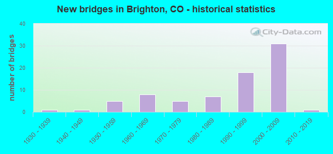
- New bridges - historical statistics
- 11930-1939
- 11940-1949
- 51950-1959
- 81960-1969
- 51970-1979
- 71980-1989
- 181990-1999
- 312000-2009
- 12010-2019

- Reconstructed bridges - Historical Statistics
- 11960-1969
- 11970-1979
- 11980-1989
- 31990-1999


- Bridge Condition - Deck
- 2.2%Very good
- 52.2%Good
- 28.3%Satisfactory
- 17.4%Fair

- Bridge Condition - Superstructure
- 4.3%Very good
- 45.7%Good
- 30.4%Satisfactory
- 17.4%Fair
- 2.2%Poor

- Bridge Condition - Substructure
- 4.3%Very good
- 50.0%Good
- 32.6%Satisfactory
- 13.0%Fair

- Bridge Condition - Channel
- 54.3%Very good
- 23.9%Good
- 13.0%Satisfactory
- 6.5%Fair
- 2.2%Poor

- Bridge Condition - Culverts
- 21.4%Good
- 64.3%Satisfactory
- 14.3%Fair
Find on map >> Show street view
Structure Number: E-18-B, Location: 0.3 MI W OF JCT SH7 (Lat: 39.983550, Lng: -104.738908), Route carried "on" structure: Interstate 76A, Year Built: 1935, Year Reconstructed: 1986, Status: Open, Structure Length: 0.66m (2.17ft), Average Daily Traffic: 28,000 (year 2020), Truck Traffic: 15%, Average Future Daily Traffic: 46,480 (year 2040), Design Load: H 15, Features Intersected: WEST BURLINGTON CANAL, Facility Carried by Structure: I 76 ML
Minimum Vertical Clearance: 30.45m (99.90ft), Kilometerpoint: 37.684, Lanes on structure: 8, Base Highway Network: Yes, Owner: State Highway Agency, Approaching Roadway Width: 42.1m (138.1ft), Skew: 31 degrees, Material/Design: Concrete, Design/Construction: Culvert, Number Of Spans In Main Unit: 2, Length of Maximum Span: 3.1m (10.2ft), Out-to-Out Width: 73.9m (242.5ft)
Condition: Channel: Satisfactory, Culverts: Satisfactory, Operating Rating: 36.3 metric tons, Method Used To Determine Operating Rating: Field evaluation and documented engineering judgment, Inventory Rating: 32.7 metric tons, Method Used To Determine Inventory Rating: Field evaluation and documented engineering judgment, Structural Evaluation: Equal to present minimum criteria, Waterway Adequacy: Equal to present desirable criteria, Approach Roadway Alignment: Equal to present desirable criteria, Designated Inspection Frequency: Every 24 months, Inspection Date: Febuary 2021
Find on map >> Show street view
Structure Number: E-470-35.34D, Location: 35.34 MI FROM I25 (Lat: 39.927811, Lng: -104.799200), Route carried "on" structure: Ramp Other road 470, Year Built: 2002, Status: Open, Structure Length: 15.85m (52.00ft), Average Daily Traffic: 3,000 (year 2018), Truck Traffic: 6%, Average Future Daily Traffic: 3,382 (year 2035), Design Load: HS 25 or greater, Features Intersected: BNSFRR, Cameron Drive
Minimum Vertical Clearance: 30+ m (98+ ft), Kilometerpoint: 1.015, Lanes on structure: 1, Lanes under structure: 2, Toll: On toll road, Owner: Local Toll Authority, Approaching Roadway Width: 7.6m (24.9ft), Material/Design: Steel continuous, Design/Construction: Stringer/Multi-beam, Number Of Spans In Main Unit: 4, Length of Maximum Span: 41.6m (136.5ft), Curb-To-Curb Width: 7.6m (24.9ft), Out-to-Out Width: 8.5m (27.9ft)
Condition: Deck: Good, Superstructure: Good, Substructure: Good, Channel: Satisfactory, Operating Rating: 45.0 metric tons, Method Used To Determine Operating Rating: Load and Resistance Factor Rating (LRFR) rating reported by rating factor(RF) method using HL-93 loadings, Inventory Rating: 34.7 metric tons, Method Used To Determine Inventory Rating: Load and Resistance Factor Rating (LRFR) rating reported by rating factor(RF) method using HL-93 loadings, Structural Evaluation: Better than present minimum criteria, Deck Geometry: Better than present minimum criteria, Underclear: Somewhat better than minimum adequacy, Waterway Adequacy: Equal to present desirable criteria, Approach Roadway Alignment: Equal to present desirable criteria, Designated Inspection Frequency: Every 24 months, Inspection Date: July 2021, Deck Structure Type: Concrete Cast-file-Place, Wearing Surface/Protective System: Wearing Surface: Integral Concrete, Deck Protection: Epoxy Coated Reinforcing
Find on map >> Show street view
Structure Number: E-470-35.44A, Location: 35.44 MI FROM I25 (Lat: 39.924881, Lng: -104.803381), Route carried "on" structure: Other road 470, Year Built: 2001, Status: Open, Structure Length: 20.67m (67.81ft), Average Daily Traffic: 21,177 (year 2018), Truck Traffic: 6%, Average Future Daily Traffic: 37,695 (year 2038), Design Load: HS 25 or greater, Features Intersected: I76, BNSFRR
Minimum Vertical Clearance: 30+ m (98+ ft), Kilometerpoint: 57.205, Lanes on structure: 2, Lanes under structure: 7, Toll: On toll road, Owner: Local Toll Authority, Approaching Roadway Width: 11.6m (38.1ft), Skew: 1 degrees, Material/Design: Prestressed concrete continuous, Design/Construction: Stringer/Multi-beam, Number Of Spans In Main Unit: 5, Length of Maximum Span: 40.4m (132.5ft), Curb-To-Curb Width: 11.6m (38.1ft), Out-to-Out Width: 12.2m (40.0ft)
Condition: Deck: Good, Superstructure: Good, Substructure: Good, Operating Rating: 44.1 metric tons, Method Used To Determine Operating Rating: Load and Resistance Factor Rating (LRFR) rating reported by rating factor(RF) method using HL-93 loadings, Inventory Rating: 30.8 metric tons, Method Used To Determine Inventory Rating: Load and Resistance Factor Rating (LRFR) rating reported by rating factor(RF) method using HL-93 loadings, Structural Evaluation: Better than present minimum criteria, Deck Geometry: Equal to present minimum criteria, Underclear: Better than present minimum criteria, Approach Roadway Alignment: Equal to present desirable criteria, Designated Inspection Frequency: Every 24 months, Inspection Date: July 2021, Deck Structure Type: Concrete Cast-file-Place, Wearing Surface/Protective System: Wearing Surface: Bituminous, Membrane: Built-up, Deck Protection: Epoxy Coated Reinforcing
Find on map >> Show street view
Structure Number: E-470-35.44B, Location: 35.44 MI FROM I25 (Lat: 39.924719, Lng: -104.803600), Route carried "on" structure: Other road 470, Year Built: 2001, Status: Open, Structure Length: 20.67m (67.81ft), Average Daily Traffic: 21,940 (year 2018), Truck Traffic: 6%, Average Future Daily Traffic: 39,053 (year 2038), Design Load: HS 25 or greater, Features Intersected: I76, BNSFRR
Minimum Vertical Clearance: 30+ m (98+ ft), Kilometerpoint: 57.209, Lanes on structure: 3, Lanes under structure: 7, Toll: On toll road, Owner: Local Toll Authority, Approaching Roadway Width: 14.0m (45.9ft), Skew: 11 degrees, Material/Design: Prestressed concrete continuous, Design/Construction: Stringer/Multi-beam, Number Of Spans In Main Unit: 5, Length of Maximum Span: 40.4m (132.5ft), Curb-To-Curb Width: 14.0m (45.9ft), Out-to-Out Width: 14.6m (47.9ft)
Condition: Deck: Good, Superstructure: Good, Substructure: Good, Operating Rating: 42.4 metric tons, Method Used To Determine Operating Rating: Load and Resistance Factor Rating (LRFR) rating reported by rating factor(RF) method using HL-93 loadings, Inventory Rating: 31.1 metric tons, Method Used To Determine Inventory Rating: Load and Resistance Factor Rating (LRFR) rating reported by rating factor(RF) method using HL-93 loadings, Structural Evaluation: Better than present minimum criteria, Deck Geometry: Meets minimum limits, Underclear: Equal to present minimum criteria, Approach Roadway Alignment: Equal to present desirable criteria, Designated Inspection Frequency: Every 24 months, Inspection Date: July 2021, Deck Structure Type: Concrete Cast-file-Place, Wearing Surface/Protective System: Wearing Surface: Bituminous, Membrane: Built-up, Deck Protection: Epoxy Coated Reinforcing
Find on map >> Show street view
Structure Number: E-470-35.46D, Location: 35.46 MI FROM I25 (Lat: 39.925700, Lng: -104.803119), Route carried "on" structure: Ramp Other road 470, Year Built: 2001, Status: Open, Structure Length: 6.68m (21.92ft), Average Daily Traffic: 2,700 (year 2021), Average Future Daily Traffic: 4,806 (year 2041), Design Load: HS 25 or greater, Features Intersected: Relocated Third Creek
Minimum Vertical Clearance: 30+ m (98+ ft), Kilometerpoint: 0.939, Lanes on structure: 1, Toll: On toll road, Owner: Local Toll Authority, Approaching Roadway Width: 7.6m (24.9ft), Material/Design: Prestressed concrete continuous, Design/Construction: Stringer/Multi-beam, Number Of Spans In Main Unit: 3, Length of Maximum Span: 21.3m (69.9ft), Curb-To-Curb Width: 7.6m (24.9ft), Out-to-Out Width: 8.5m (27.9ft)
Condition: Deck: Good, Superstructure: Good, Substructure: Very good, Channel: Very good, Operating Rating: 69.0 metric tons, Method Used To Determine Operating Rating: Load and Resistance Factor Rating (LRFR) rating reported by rating factor(RF) method using HL-93 loadings, Inventory Rating: 53.5 metric tons, Method Used To Determine Inventory Rating: Load and Resistance Factor Rating (LRFR) rating reported by rating factor(RF) method using HL-93 loadings, Structural Evaluation: Better than present minimum criteria, Deck Geometry: Better than present minimum criteria, Waterway Adequacy: Equal to present desirable criteria, Approach Roadway Alignment: Equal to present desirable criteria, Designated Inspection Frequency: Every 24 months, Inspection Date: July 2021, Deck Structure Type: Concrete Cast-file-Place, Wearing Surface/Protective System: Wearing Surface: Epoxy Overlay, Deck Protection: Epoxy Coated Reinforcing
Find on map >> Show street view
Structure Number: E-470-36.27C, Location: 36.27 MI FROM I25 (Lat: 39.928311, Lng: -104.818369), Route carried "on" structure: State highway 2D, Year Built: 2002, Status: Open, Structure Length: 7.21m (23.65ft), Average Daily Traffic: 27,878 (year 2020), Truck Traffic: 6%, Average Future Daily Traffic: 21,360 (year 2035), Design Load: HS 25 or greater, Features Intersected: E-470, Facility Carried by Structure: SABLE ROAD/SH 2
Minimum Vertical Clearance: 30+ m (98+ ft), Kilometerpoint: 1.547, Lanes on structure: 2, Lanes under structure: 4, Owner: Local Toll Authority, Approaching Roadway Width: 12.2m (40.0ft), Material/Design: Prestressed concrete continuous, Design/Construction: Stringer/Multi-beam, Number Of Spans In Main Unit: 2, Length of Maximum Span: 36.0m (118.1ft), Curb-To-Curb Width: 12.2m (40.0ft), Out-to-Out Width: 13.1m (43.0ft)
Condition: Deck: Good, Superstructure: Very good, Substructure: Good, Operating Rating: 45.4 metric tons, Method Used To Determine Operating Rating: Load Factor (LF), Inventory Rating: 40.8 metric tons, Method Used To Determine Inventory Rating: Load Factor (LF), Structural Evaluation: Better than present minimum criteria, Deck Geometry: Somewhat better than minimum adequacy, Underclear: Equal to present minimum criteria, Approach Roadway Alignment: Equal to present desirable criteria, Designated Inspection Frequency: Every 24 months, Inspection Date: July 2021, Deck Structure Type: Concrete Cast-file-Place, Wearing Surface/Protective System: Wearing Surface: Bituminous, Membrane: Built-up, Deck Protection: Epoxy Coated Reinforcing
Find on map >> Show street view
Structure Number: E-470-37.07A, Location: 37.07 MI FROM I25 (Lat: 39.928739, Lng: -104.833711), Route carried "on" structure: Other road 25, Year Built: 2001, Status: Open, Structure Length: 6.26m (20.54ft), Average Daily Traffic: 32,000 (year 2018), Average Future Daily Traffic: 57,919 (year 2038), Design Load: HS 25 or greater, Features Intersected: Second Creek, Facility Carried by Structure: E-470 NB
Minimum Vertical Clearance: 30+ m (98+ ft), Kilometerpoint: 59.842, Lanes on structure: 2, Toll: On toll road, Owner: Local Toll Authority, Approaching Roadway Width: 11.6m (38.1ft), Skew: 13 degrees, Material/Design: Prestressed concrete continuous, Design/Construction: Stringer/Multi-beam, Number Of Spans In Main Unit: 2, Length of Maximum Span: 30.1m (98.8ft), Curb-To-Curb Width: 11.6m (38.1ft), Out-to-Out Width: 12.2m (40.0ft)
Condition: Deck: Good, Superstructure: Good, Substructure: Very good, Channel: Very good, Operating Rating: 36.9 metric tons, Method Used To Determine Operating Rating: Load and Resistance Factor Rating (LRFR) rating reported by rating factor(RF) method using HL-93 loadings, Inventory Rating: 28.2 metric tons, Method Used To Determine Inventory Rating: Load and Resistance Factor Rating (LRFR) rating reported by rating factor(RF) method using HL-93 loadings, Structural Evaluation: Better than present minimum criteria, Deck Geometry: Better than present minimum criteria, Waterway Adequacy: Equal to present desirable criteria, Approach Roadway Alignment: Equal to present desirable criteria, Designated Inspection Frequency: Every 24 months, Inspection Date: July 2021, Deck Structure Type: Concrete Cast-file-Place, Wearing Surface/Protective System: Wearing Surface: Bituminous, Membrane: Built-up, Deck Protection: Epoxy Coated Reinforcing
Find on map >> Show street view
Structure Number: E-470-37.07B, Location: 37.07 MI FROM I25 (Lat: 39.928519, Lng: -104.833631), Route carried "on" structure: Other road 470, Year Built: 2002, Status: Open, Structure Length: 6.23m (20.44ft), Average Daily Traffic: 20,682 (year 2018), Truck Traffic: 6%, Average Future Daily Traffic: 36,813 (year 2038), Design Load: HS 25 or greater, Features Intersected: Second Creek
Minimum Vertical Clearance: 30+ m (98+ ft), Kilometerpoint: 59.869, Lanes on structure: 2, Toll: On toll road, Owner: Local Toll Authority, Approaching Roadway Width: 12.2m (40.0ft), Skew: 3 degrees, Material/Design: Prestressed concrete continuous, Design/Construction: Stringer/Multi-beam, Number Of Spans In Main Unit: 2, Length of Maximum Span: 30.0m (98.4ft), Curb-To-Curb Width: 12.2m (40.0ft), Out-to-Out Width: 12.8m (42.0ft)
Condition: Deck: Good, Superstructure: Good, Substructure: Good, Channel: Very good, Operating Rating: 35.0 metric tons, Method Used To Determine Operating Rating: Load and Resistance Factor Rating (LRFR) rating reported by rating factor(RF) method using HL-93 loadings, Inventory Rating: 26.9 metric tons, Method Used To Determine Inventory Rating: Load and Resistance Factor Rating (LRFR) rating reported by rating factor(RF) method using HL-93 loadings, Structural Evaluation: Equal to present minimum criteria, Deck Geometry: Better than present minimum criteria, Waterway Adequacy: Equal to present desirable criteria, Approach Roadway Alignment: Equal to present desirable criteria, Designated Inspection Frequency: Every 24 months, Inspection Date: July 2021, Deck Structure Type: Concrete Cast-file-Place, Wearing Surface/Protective System: Wearing Surface: Bituminous, Membrane: Built-up, Deck Protection: Epoxy Coated Reinforcing
Find on map >> Show street view
Structure Number: E-470-37.30CBC, Location: 37.30 MI FROM I-25 (Lat: 39.929111, Lng: -104.836331), Route carried "on" structure: Other road 470B, Year Built: 2002, Status: Open, Structure Length: 0.75m (2.46ft), Average Daily Traffic: 40,466 (year 2018), Truck Traffic: 2%, Average Future Daily Traffic: 72,029 (year 2038), Design Load: HS 25 or greater, Features Intersected: LOCAL DRAINAGE, Facility Carried by Structure: E-470
Minimum Vertical Clearance: 30+ m (98+ ft), Kilometerpoint: 60.106, Lanes on structure: 4, Toll: On toll road, Owner: Local Toll Authority, Approaching Roadway Width: 23.2m (76.1ft), Skew: 32 degrees, Material/Design: Concrete, Design/Construction: Culvert, Number Of Spans In Main Unit: 2, Length of Maximum Span: 3.4m (11.2ft), Out-to-Out Width: 63.6m (208.7ft)
Condition: Channel: Good, Culverts: Satisfactory, Operating Rating: 89.8 metric tons, Method Used To Determine Operating Rating: Field evaluation and documented engineering judgment, Inventory Rating: 89.8 metric tons, Method Used To Determine Inventory Rating: Field evaluation and documented engineering judgment, Structural Evaluation: Equal to present minimum criteria, Waterway Adequacy: Equal to present desirable criteria, Approach Roadway Alignment: Equal to present desirable criteria, Designated Inspection Frequency: Every 24 months, Inspection Date: July 2021
Find on map >> Show street view
Structure Number: E-470-37.72C, Location: 37.72 MI FROM I25 (Lat: 39.927639, Lng: -104.849539), Route carried "on" structure: Ramp Other road 470, Year Built: 2001, Status: Open, Structure Length: 7.03m (23.06ft), Average Daily Traffic: 1,500 (year 2018), Truck Traffic: 6%, Average Future Daily Traffic: 2,100 (year 2038), Design Load: HS 25 or greater, Features Intersected: US 85 ML
Minimum Vertical Clearance: 30+ m (98+ ft), Kilometerpoint: 0.065, Lanes on structure: 2, Lanes under structure: 4, Toll: On toll road, Owner: Local Toll Authority, Approaching Roadway Width: 15.8m (51.8ft), Material/Design: Prestressed concrete continuous, Design/Construction: Stringer/Multi-beam, Number Of Spans In Main Unit: 2, Length of Maximum Span: 34.5m (113.2ft), Curb-To-Curb Width: 15.8m (51.8ft), Out-to-Out Width: 16.8m (55.1ft)
Condition: Deck: Good, Superstructure: Good, Substructure: Good, Operating Rating: 45.4 metric tons, Method Used To Determine Operating Rating: Field evaluation and documented engineering judgment, Inventory Rating: 40.8 metric tons, Method Used To Determine Inventory Rating: Field evaluation and documented engineering judgment, Structural Evaluation: Better than present minimum criteria, Deck Geometry: Superior to present desirable criteria, Underclear: Equal to present minimum criteria, Approach Roadway Alignment: Equal to present desirable criteria, Designated Inspection Frequency: Every 24 months, Inspection Date: July 2021, Deck Structure Type: Concrete Cast-file-Place, Wearing Surface/Protective System: Wearing Surface: Integral Concrete, Deck Protection: Epoxy Coated Reinforcing
Find on map >> Show street view
Structure Number: E-470-37.83A, Location: 37.83 MI FROM I25 (Lat: 39.933631, Lng: -104.845169), Route carried "on" structure: Other road 470, Year Built: 2001, Status: Open, Structure Length: 23.83m (78.18ft), Average Daily Traffic: 19,615 (year 2018), Truck Traffic: 6%, Average Future Daily Traffic: 34,914 (year 2038), Design Load: HS 25 or greater, Features Intersected: US85, UPRR, FULTON DITCH
Minimum Vertical Clearance: 30+ m (98+ ft), Kilometerpoint: 61.020, Lanes on structure: 2, Lanes under structure: 4, Toll: On toll road, Owner: Local Toll Authority, Approaching Roadway Width: 11.6m (38.1ft), Skew: 2 degrees, Material/Design: Prestressed concrete continuous, Design/Construction: Stringer/Multi-beam, Number Of Spans In Main Unit: 6, Length of Maximum Span: 39.4m (129.3ft), Curb-To-Curb Width: 11.6m (38.1ft), Out-to-Out Width: 12.2m (40.0ft)
Condition: Deck: Good, Superstructure: Good, Substructure: Good, Channel: Very good, Operating Rating: 40.8 metric tons, Method Used To Determine Operating Rating: Load and Resistance Factor Rating (LRFR) rating reported by rating factor(RF) method using HL-93 loadings, Inventory Rating: 31.1 metric tons, Method Used To Determine Inventory Rating: Load and Resistance Factor Rating (LRFR) rating reported by rating factor(RF) method using HL-93 loadings, Structural Evaluation: Better than present minimum criteria, Deck Geometry: Equal to present minimum criteria, Underclear: Equal to present minimum criteria, Waterway Adequacy: Equal to present desirable criteria, Approach Roadway Alignment: Equal to present desirable criteria, Designated Inspection Frequency: Every 24 months, Inspection Date: July 2021, Deck Structure Type: Concrete Cast-file-Place, Wearing Surface/Protective System: Wearing Surface: Bituminous, Membrane: Built-up, Deck Protection: Epoxy Coated Reinforcing
Find on map >> Show street view
Structure Number: E-470-37.83B, Location: 37.83 MI FROM I25 (Lat: 39.933411, Lng: -104.845339), Route carried "on" structure: Other road 470, Year Built: 2002, Status: Open, Structure Length: 23.76m (77.95ft), Average Daily Traffic: 20,095 (year 2018), Truck Traffic: 6%, Average Future Daily Traffic: 35,769 (year 2038), Design Load: HS 25 or greater, Features Intersected: US85, UPRR, FULTON DITCH
Minimum Vertical Clearance: 30+ m (98+ ft), Kilometerpoint: 61.011, Lanes on structure: 3, Lanes under structure: 4, Toll: On toll road, Owner: Local Toll Authority, Approaching Roadway Width: 14.0m (45.9ft), Skew: 2 degrees, Material/Design: Prestressed concrete continuous, Design/Construction: Stringer/Multi-beam, Number Of Spans In Main Unit: 6, Length of Maximum Span: 39.0m (128.0ft), Curb-To-Curb Width: 14.0m (45.9ft), Out-to-Out Width: 14.6m (47.9ft)
Condition: Deck: Good, Superstructure: Good, Substructure: Good, Channel: Very good, Operating Rating: 43.4 metric tons, Method Used To Determine Operating Rating: Load and Resistance Factor Rating (LRFR) rating reported by rating factor(RF) method using HL-93 loadings, Inventory Rating: 28.8 metric tons, Method Used To Determine Inventory Rating: Load and Resistance Factor Rating (LRFR) rating reported by rating factor(RF) method using HL-93 loadings, Structural Evaluation: Better than present minimum criteria, Deck Geometry: Meets minimum limits, Underclear: Equal to present minimum criteria, Waterway Adequacy: Equal to present desirable criteria, Approach Roadway Alignment: Equal to present desirable criteria, Designated Inspection Frequency: Every 24 months, Inspection Date: July 2021, Deck Structure Type: Concrete Cast-file-Place, Wearing Surface/Protective System: Wearing Surface: Bituminous, Membrane: Built-up, Deck Protection: Epoxy Coated Reinforcing
Find on map >> Show street view
Structure Number: E-470-38.38C, Location: 38.38 MILES FROM I25 (Lat: 39.940131, Lng: -104.851000), Route carried "on" structure: Ramp Other road 470, Year Built: 2001, Status: Open, Structure Length: 9.29m (30.48ft), Average Daily Traffic: 1,500 (year 2018), Truck Traffic: 6%, Average Future Daily Traffic: 2,100 (year 2038), Design Load: HS 25 or greater, Features Intersected: E-470, Facility Carried by Structure: US 85 CONNECTOR
Minimum Vertical Clearance: 30+ m (98+ ft), Kilometerpoint: 0.832, Lanes on structure: 2, Lanes under structure: 5, Owner: Local Toll Authority, Approaching Roadway Width: 16.8m (55.1ft), Skew: 34 degrees, Material/Design: Prestressed concrete continuous, Design/Construction: Stringer/Multi-beam, Number Of Spans In Main Unit: 2, Length of Maximum Span: 45.5m (149.3ft), Curb-To-Curb Width: 17.4m (57.1ft), Out-to-Out Width: 18.0m (59.1ft)
Condition: Deck: Good, Superstructure: Good, Substructure: Good, Operating Rating: 45.4 metric tons, Method Used To Determine Operating Rating: Field evaluation and documented engineering judgment, Inventory Rating: 40.8 metric tons, Method Used To Determine Inventory Rating: Field evaluation and documented engineering judgment, Structural Evaluation: Better than present minimum criteria, Deck Geometry: Superior to present desirable criteria, Underclear: High priority of corrective action, Approach Roadway Alignment: Equal to present desirable criteria, Designated Inspection Frequency: Every 24 months, Inspection Date: July 2021, Deck Structure Type: Concrete Cast-file-Place, Wearing Surface/Protective System: Wearing Surface: Integral Concrete, Deck Protection: Epoxy Coated Reinforcing
Find on map >> Show street view
Structure Number: E-470-38.47C, Location: 38.47 MI FROM I25 (Lat: 39.941250, Lng: -104.852031), Route carried "on" structure: County highway BRIGH, Year Built: 2001, Status: Open, Structure Length: 9.88m (32.41ft), Average Daily Traffic: 3,200 (year 2018), Truck Traffic: 4%, Average Future Daily Traffic: 4,480 (year 2038), Design Load: HS 25 or greater, Features Intersected: E-470
Minimum Vertical Clearance: 30+ m (98+ ft), Kilometerpoint: 3.044, Lanes on structure: 2, Lanes under structure: 6, Owner: Local Toll Authority, Approaching Roadway Width: 12.2m (40.0ft), Skew: 2 degrees, Material/Design: Prestressed concrete continuous, Design/Construction: Stringer/Multi-beam, Number Of Spans In Main Unit: 2, Length of Maximum Span: 48.2m (158.1ft), Curb-To-Curb Width: 12.3m (40.4ft), Out-to-Out Width: 13.0m (42.7ft)
Condition: Deck: Good, Superstructure: Good, Substructure: Good, Operating Rating: 45.4 metric tons, Method Used To Determine Operating Rating: Field evaluation and documented engineering judgment, Inventory Rating: 40.8 metric tons, Method Used To Determine Inventory Rating: Field evaluation and documented engineering judgment, Structural Evaluation: Better than present minimum criteria, Deck Geometry: Equal to present minimum criteria, Underclear: High priority of corrective action, Approach Roadway Alignment: Equal to present desirable criteria, Designated Inspection Frequency: Every 24 months, Inspection Date: July 2021, Deck Structure Type: Concrete Cast-file-Place, Wearing Surface/Protective System: Wearing Surface: Bituminous, Membrane: Built-up, Deck Protection: Epoxy Coated Reinforcing
Find on map >> Show street view
Structure Number: E-470-38.97A, Location: 38.97 MI FROM I25 (Lat: 39.947200, Lng: -104.858589), Route carried "on" structure: Other road 470, Year Built: 2003, Status: Open, Structure Length: 27.66m (90.75ft), Average Daily Traffic: 18,870 (year 2018), Truck Traffic: 6%, Average Future Daily Traffic: 33,588 (year 2038), Design Load: HS 25 or greater, Features Intersected: South Platte River
Minimum Vertical Clearance: 30+ m (98+ ft), Kilometerpoint: 62.929, Lanes on structure: 2, Toll: On toll road, Owner: Local Toll Authority, Approaching Roadway Width: 11.6m (38.1ft), Skew: 3 degrees, Material/Design: Prestressed concrete continuous, Design/Construction: Stringer/Multi-beam, Number Of Spans In Main Unit: 6, Length of Maximum Span: 44.8m (147.0ft), Curb-To-Curb Width: 11.6m (38.1ft), Out-to-Out Width: 12.2m (40.0ft)
Condition: Deck: Good, Superstructure: Good, Substructure: Good, Channel: Fair, Operating Rating: 47.3 metric tons, Method Used To Determine Operating Rating: Load and Resistance Factor Rating (LRFR) rating reported by rating factor(RF) method using HL-93 loadings, Inventory Rating: 25.3 metric tons, Method Used To Determine Inventory Rating: Load and Resistance Factor Rating (LRFR) rating reported by rating factor(RF) method using HL-93 loadings, Structural Evaluation: Equal to present minimum criteria, Deck Geometry: Equal to present minimum criteria, Waterway Adequacy: Equal to present desirable criteria, Approach Roadway Alignment: Equal to present desirable criteria, Designated Inspection Frequency: Every 24 months, Inspection Date: July 2021, Deck Structure Type: Concrete Cast-file-Place, Wearing Surface/Protective System: Wearing Surface: Bituminous, Membrane: Built-up, Deck Protection: Epoxy Coated Reinforcing
Find on map >> Show street view
Structure Number: E-470-38.97B, Location: 38.97 MI FROM I25 (Lat: 39.946969, Lng: -104.858800), Route carried "on" structure: Other road 470, Year Built: 2003, Status: Open, Structure Length: 27.66m (90.75ft), Average Daily Traffic: 19,215 (year 2018), Truck Traffic: 6%, Average Future Daily Traffic: 34,202 (year 2038), Design Load: HS 25 or greater, Features Intersected: South Platte River
Minimum Vertical Clearance: 30+ m (98+ ft), Kilometerpoint: 62.927, Lanes on structure: 2, Toll: On toll road, Owner: Local Toll Authority, Approaching Roadway Width: 11.6m (38.1ft), Skew: 3 degrees, Material/Design: Prestressed concrete continuous, Design/Construction: Stringer/Multi-beam, Number Of Spans In Main Unit: 6, Length of Maximum Span: 44.8m (147.0ft), Curb-To-Curb Width: 11.6m (38.1ft), Out-to-Out Width: 12.2m (40.0ft)
Condition: Deck: Good, Superstructure: Good, Substructure: Good, Channel: Fair, Operating Rating: 47.3 metric tons, Method Used To Determine Operating Rating: Load and Resistance Factor Rating (LRFR) rating reported by rating factor(RF) method using HL-93 loadings, Inventory Rating: 25.3 metric tons, Method Used To Determine Inventory Rating: Load and Resistance Factor Rating (LRFR) rating reported by rating factor(RF) method using HL-93 loadings, Structural Evaluation: Equal to present minimum criteria, Deck Geometry: Equal to present minimum criteria, Waterway Adequacy: Equal to present desirable criteria, Approach Roadway Alignment: Equal to present desirable criteria, Designated Inspection Frequency: Every 24 months, Inspection Date: July 2021, Deck Structure Type: Concrete Cast-file-Place, Wearing Surface/Protective System: Wearing Surface: Bituminous, Membrane: Built-up, Deck Protection: Epoxy Coated Reinforcing
Find on map >> Show street view
Structure Number: WEL004.0-027.0A, Location: 0.9 Mi E of US Hwy 85 (Lat: 40.014944, Lng: -104.797000), Route carried "on" structure: County highway , Year Built: 1970, Status: Open, Structure Length: 0.92m (3.02ft), Average Daily Traffic: 4,257 (year 2020), Truck Traffic: 32%, Average Future Daily Traffic: 6,045 (year 2040), Design Load: HS 20, Features Intersected: Fulton Ditch, Facility Carried by Structure: County Road 4
Minimum Vertical Clearance: 30+ m (98+ ft), Kilometerpoint: 0.557, Lanes on structure: 2, Owner: County Highway Agency, Approaching Roadway Width: 7.0m (23.0ft), Material/Design: Prestressed concrete, Design/Construction: Tee Beam, Number Of Spans In Main Unit: 1, Length of Maximum Span: 8.8m (28.9ft), Curb-To-Curb Width: 8.4m (27.6ft), Out-to-Out Width: 8.5m (27.9ft)
Condition: Deck: Satisfactory, Superstructure: Satisfactory, Substructure: Satisfactory, Channel: Good, Operating Rating: 32.7 metric tons, Method Used To Determine Operating Rating: Field evaluation and documented engineering judgment, Inventory Rating: 32.7 metric tons, Method Used To Determine Inventory Rating: Field evaluation and documented engineering judgment, Structural Evaluation: Equal to present minimum criteria, Deck Geometry: High priority of corrective action, Waterway Adequacy: Equal to present desirable criteria, Approach Roadway Alignment: Equal to present desirable criteria, Designated Inspection Frequency: Every 24 months, Inspection Date: March 2022, Deck Structure Type: Other, Wearing Surface/Protective System: Wearing Surface: Bituminous
Find on map >> Show street view
Structure Number: WEL006.0_025.0B, Location: 1.4 Mi E of Co Rd 23 (Lat: 40.029528, Lng: -104.820639), Route carried "on" structure: County highway , Year Built: 2001, Status: Open, Structure Length: 1.78m (5.84ft), Average Daily Traffic: 2,087 (year 2020), Truck Traffic: 34%, Average Future Daily Traffic: 2,964 (year 2040), Design Load: HS 20, Features Intersected: South Platte R. Overflow, Facility Carried by Structure: County Road 6
Minimum Vertical Clearance: 30+ m (98+ ft), Kilometerpoint: 12.004, Lanes on structure: 2, Owner: County Highway Agency, Approaching Roadway Width: 7.3m (24.0ft), Material/Design: Steel, Design/Construction: Stringer/Multi-beam, Number Of Spans In Main Unit: 1, Length of Maximum Span: 17.4m (57.1ft), Curb-To-Curb Width: 12.0m (39.4ft), Out-to-Out Width: 12.3m (40.4ft)
Condition: Deck: Very good, Superstructure: Satisfactory, Substructure: Satisfactory, Channel: Fair, Operating Rating: 58.4 metric tons, Method Used To Determine Operating Rating: Load Factor (LF), Inventory Rating: 35.0 metric tons, Method Used To Determine Inventory Rating: Load Factor (LF), Structural Evaluation: Equal to present minimum criteria, Deck Geometry: Somewhat better than minimum adequacy, Waterway Adequacy: Equal to present minimum criteria, Approach Roadway Alignment: Equal to present desirable criteria, Designated Inspection Frequency: Every 24 months, Inspection Date: April 2020, Deck Structure Type: Corrugated Steel, Wearing Surface/Protective System: Wearing Surface: Bituminous
Find on map >> Show street view
Structure Number: WEL006.0_027.0A, Location: 200 Ft W of Co Rd 29 (Lat: 40.029444, Lng: -104.792361), Route carried "on" structure: County highway , Year Built: 1999, Status: Open, Structure Length: 0.90m (2.95ft), Average Daily Traffic: 574 (year 2020), Truck Traffic: 31%, Average Future Daily Traffic: 815 (year 2040), Design Load: HS 20, Features Intersected: Fulton Ditch, Facility Carried by Structure: County Road 6
Minimum Vertical Clearance: 30+ m (98+ ft), Kilometerpoint: 0.061, Lanes on structure: 2, Owner: County Highway Agency, Approaching Roadway Width: 7.3m (24.0ft), Material/Design: Steel, Design/Construction: Stringer/Multi-beam, Number Of Spans In Main Unit: 1, Length of Maximum Span: 8.0m (26.2ft), Curb-To-Curb Width: 9.5m (31.2ft), Out-to-Out Width: 9.8m (32.2ft)
Condition: Deck: Good, Superstructure: Satisfactory, Substructure: Satisfactory, Channel: Good, Operating Rating: 54.8 metric tons, Method Used To Determine Operating Rating: Load Factor (LF), Inventory Rating: 32.8 metric tons, Method Used To Determine Inventory Rating: Load Factor (LF), Structural Evaluation: Equal to present minimum criteria, Deck Geometry: Equal to present minimum criteria, Waterway Adequacy: Equal to present desirable criteria, Approach Roadway Alignment: Equal to present desirable criteria, Designated Inspection Frequency: Every 24 months, Inspection Date: March 2022, Deck Structure Type: Corrugated Steel, Wearing Surface/Protective System: Wearing Surface: Gravel
Find on map >> Show street view
Structure Number: E-17-JC, Location: BRIGHTON (Lat: 39.986606, Lng: -104.823864), Route carried "under" structure: State highway 7D, Year Built: 1965, Structure Length: 0. m, Average Daily Traffic: 17,000 (year 2011), Truck Traffic: 4%, Features Intersected: SH 7 ML, Facility Carried by Structure: US 85 ML SBND
Minimum Vertical Clearance: 5.16m (16.93ft), Kilometerpoint: 123.870, Lanes on structure: 2, Lanes under structure: 4, Material/Design: Steel, Design/Construction: Stringer/Multi-beam, Length of Maximum Span: 24.4m (80.1ft)
Find on map >> Show street view
Structure Number: E-17-JD, Location: BRIGHTON (Lat: 39.986606, Lng: -104.823667), Route carried "under" structure: State highway 7D, Year Built: 1965, Structure Length: 0. m, Average Daily Traffic: 17,000 (year 2011), Truck Traffic: 4%, Features Intersected: SH 7 ML, Facility Carried by Structure: US 85 ML NBND
Minimum Vertical Clearance: 5.64m (18.50ft), Kilometerpoint: 123.872, Lanes on structure: 2, Lanes under structure: 4, Material/Design: Steel, Design/Construction: Stringer/Multi-beam, Length of Maximum Span: 25.0m (82.0ft)
Find on map >> Show street view
Structure Number: E-17-MI, Location: 4.98 MI NE OF JCT SH 51 - (Lat: 39.972369, Lng: -104.751817), Route carried "under" structure: Interstate 76A, Year Built: 1986, Structure Length: 0. m, Average Daily Traffic: 11,993 (year 2016), Truck Traffic: 15%, Features Intersected: I 76 ML, Facility Carried by Structure: BROMLEY LANE
Minimum Vertical Clearance: 5.18m (16.99ft), Kilometerpoint: 3.211, Lanes on structure: 2, Lanes under structure: 4, Material/Design: Steel continuous, Design/Construction: Stringer/Multi-beam, Length of Maximum Span: 40.5m (132.9ft)
Find on map >> Show street view
Structure Number: E-17-PQ, Location: BUCKLEY RD @ I76 and BN (Lat: 39.935594, Lng: -104.789836), Route carried "under" structure: Interstate 76A, Year Built: 1994, Structure Length: 0. m, Average Daily Traffic: 7,521 (year 2016), Truck Traffic: 18%, Features Intersected: I 76 ML, BNSF RR, Facility Carried by Structure: BUCKLEY ROAD
Minimum Vertical Clearance: 7.10m (23.29ft), Kilometerpoint: 2.345, Lanes on structure: 4, Lanes under structure: 4, Material/Design: Prestressed concrete continuous, Design/Construction: Stringer/Multi-beam, Length of Maximum Span: 55.8m (183.1ft)
Find on map >> Show street view
Structure Number: E-17-PR, Location: 136TH AVE OVER I76 ML (Lat: 39.943264, Lng: -104.785108), Route carried "under" structure: Interstate 76A, Year Built: 1994, Structure Length: 0. m, Average Daily Traffic: 43,000 (year 2018), Truck Traffic: 18%, Features Intersected: I 76 ML, Facility Carried by Structure: 136TH AVE
Minimum Vertical Clearance: 5.23m (17.16ft), Kilometerpoint: 5.562, Lanes on structure: 3, Lanes under structure: 4, Material/Design: Prestressed concrete continuous, Design/Construction: Stringer/Multi-beam, Length of Maximum Span: 37.4m (122.7ft)
Find on map >> Show street view
Structure Number: E-17-PS, Location: 2.8 MI. W. OF JCT SH 7 (Lat: 39.956342, Lng: -104.771375), Route carried "under" structure: City street , Year Built: 1994, Structure Length: 0. m, Features Intersected: 144TH AVE, Facility Carried by Structure: I 76 ML EBND
Minimum Vertical Clearance: 5.58m (18.31ft), Kilometerpoint: 0.000, Lanes on structure: 2, Lanes under structure: 4, Material/Design: Prestressed concrete continuous, Design/Construction: Stringer/Multi-beam, Length of Maximum Span: 30.2m (99.1ft)
Find on map >> Show street view
Structure Number: E-17-PT, Location: 2.8 Mi W of SH-7 (Lat: 39.956461, Lng: -104.771564), Route carried "under" structure: City street , Year Built: 1994, Structure Length: 0. m, Features Intersected: 144TH AVE, Facility Carried by Structure: I 76 ML WBND
Minimum Vertical Clearance: 5.70m (18.70ft), Kilometerpoint: 0.000, Lanes on structure: 2, Lanes under structure: 4, Material/Design: Prestressed concrete continuous, Design/Construction: Stringer/Multi-beam, Length of Maximum Span: 30.2m (99.1ft)
Find on map >> Show street view
Structure Number: E-18-AO, Location: 4.41 MI E JCT SH 51-BRIGH (Lat: 39.986878, Lng: -104.736492), Route carried "under" structure: Interstate 76A, Year Built: 1986, Structure Length: 0. m, Average Daily Traffic: 20,000 (year 2011), Truck Traffic: 15%, Features Intersected: I 76 ML, Facility Carried by Structure: SH 7 ML
Minimum Vertical Clearance: 5.36m (17.59ft), Kilometerpoint: 38.153, Lanes on structure: 2, Lanes under structure: 4, Material/Design: Steel continuous, Design/Construction: Stringer/Multi-beam, Length of Maximum Span: 43.9m (144.0ft)
Find on map >> Show street view
Structure Number: E-470-35.34D, Location: 35.34 MI FROM I25 (Lat: 39.927811, Lng: -104.799200), Route carried "under" structure: County highway CAMER, Year Built: 2002, Structure Length: 0. m, Features Intersected: BNSFRR, Cameron Drive, Facility Carried by Structure: NB E470 RAMP I76EB
Minimum Vertical Clearance: 7.25m (23.79ft), Kilometerpoint: 0.016, Lanes on structure: 1, Lanes under structure: 2, Material/Design: Steel continuous, Design/Construction: Stringer/Multi-beam, Length of Maximum Span: 41.6m (136.5ft)
Find on map >> Show street view
Structure Number: E-470-35.44A, Location: 35.44 MI FROM I25 (Lat: 39.924881, Lng: -104.803381), Route carried "under" structure: Interstate 76, Year Built: 2001, Structure Length: 0. m, Truck Traffic: 6%, Features Intersected: I76, BNSFRR, Facility Carried by Structure: E-470 NB
Minimum Vertical Clearance: 7.71m (25.30ft), Kilometerpoint: 29.226, Lanes on structure: 2, Lanes under structure: 7, Toll: On toll road, Material/Design: Prestressed concrete continuous, Design/Construction: Stringer/Multi-beam, Length of Maximum Span: 40.4m (132.5ft)
Find on map >> Show street view
Structure Number: E-470-35.44B, Location: 35.44 MI FROM I25 (Lat: 39.924719, Lng: -104.803600), Route carried "under" structure: Interstate 76, Year Built: 2001, Structure Length: 0. m, Truck Traffic: 6%, Features Intersected: I76, BNSFRR, Facility Carried by Structure: E-470 SB
Minimum Vertical Clearance: 7.80m (25.59ft), Kilometerpoint: 29.226, Lanes on structure: 3, Lanes under structure: 7, Material/Design: Prestressed concrete continuous, Design/Construction: Stringer/Multi-beam, Length of Maximum Span: 40.4m (132.5ft)
Find on map >> Show street view
Structure Number: E-470-36.27C, Location: 36.27 MI FROM I25 (Lat: 39.928311, Lng: -104.818369), Route carried "under" structure: Other road 470, Year Built: 2002, Structure Length: 0. m, Average Daily Traffic: 8,900 (year 2014), Truck Traffic: 4%, Features Intersected: E-470, Facility Carried by Structure: SABLE ROAD/SH 2
Minimum Vertical Clearance: 5.58m (18.31ft), Kilometerpoint: 1.511, Lanes on structure: 2, Lanes under structure: 4, Material/Design: Prestressed concrete continuous, Design/Construction: Stringer/Multi-beam, Length of Maximum Span: 36.0m (118.1ft)
Find on map >> Show street view
Structure Number: E-470-37.72C, Location: 37.72 MI FROM I25 (Lat: 39.927639, Lng: -104.849539), Route carried "under" structure: US 85, Year Built: 2001, Structure Length: 0. m, Truck Traffic: 6%, Features Intersected: US 85 ML, Facility Carried by Structure: E-470 CONNECTOR
Minimum Vertical Clearance: 5.33m (17.49ft), Kilometerpoint: 373.722, Lanes on structure: 2, Lanes under structure: 4, Material/Design: Prestressed concrete continuous, Design/Construction: Stringer/Multi-beam, Length of Maximum Span: 34.5m (113.2ft)
Find on map >> Show street view
Structure Number: E-470-37.83A, Location: 37.83 MI FROM I25 (Lat: 39.933631, Lng: -104.845169), Route carried "under" structure: US 85, Year Built: 2001, Structure Length: 0. m, Truck Traffic: 6%, Features Intersected: US85, UPRR, FULTON DITCH, Facility Carried by Structure: E-470 NB
Minimum Vertical Clearance: 7.22m (23.69ft), Kilometerpoint: 373.738, Lanes on structure: 2, Lanes under structure: 4, Toll: On toll road, Material/Design: Prestressed concrete continuous, Design/Construction: Stringer/Multi-beam, Length of Maximum Span: 39.4m (129.3ft)
Find on map >> Show street view
Structure Number: E-470-37.83B, Location: 37.83 MI FROM I25 (Lat: 39.933411, Lng: -104.845339), Route carried "under" structure: US 85, Year Built: 2002, Structure Length: 0. m, Truck Traffic: 6%, Features Intersected: US85, UPRR, FULTON DITCH, Facility Carried by Structure: E-470 SB
Minimum Vertical Clearance: 8.02m (26.31ft), Kilometerpoint: 373.706, Lanes on structure: 3, Lanes under structure: 4, Material/Design: Prestressed concrete continuous, Design/Construction: Stringer/Multi-beam, Length of Maximum Span: 39.0m (128.0ft)
Find on map >> Show street view
Structure Number: E-470-38.38C, Location: 38.38 MILES FROM I25 (Lat: 39.940131, Lng: -104.851000), Route carried "under" structure: Other road 470, Year Built: 2001, Structure Length: 0. m, Average Daily Traffic: 1,700 (year 2018), Truck Traffic: 6%, Features Intersected: E-470, Facility Carried by Structure: US 85 CONNECTOR
Minimum Vertical Clearance: 5.18m (16.99ft), Kilometerpoint: 1.192, Lanes on structure: 2, Lanes under structure: 5, Toll: Toll bridge, Material/Design: Prestressed concrete continuous, Design/Construction: Stringer/Multi-beam, Length of Maximum Span: 45.5m (149.3ft)
Find on map >> Show street view
Structure Number: E-470-38.47C, Location: 38.47 MI FROM I25 (Lat: 39.941250, Lng: -104.852031), Route carried "under" structure: Other road 470, Year Built: 2001, Structure Length: 0. m, Average Daily Traffic: 2,600 (year 2014), Truck Traffic: 4%, Features Intersected: E-470, Facility Carried by Structure: BRIGHTON BLVD
Minimum Vertical Clearance: 5.24m (17.19ft), Kilometerpoint: 61.911, Lanes on structure: 2, Lanes under structure: 6, Toll: Toll bridge, Material/Design: Prestressed concrete continuous, Design/Construction: Stringer/Multi-beam, Length of Maximum Span: 48.2m (158.1ft)