Bridge Statistics for Bristol, Tennessee (TN)
Condition, Traffic, Stress, Structural Evaluation, Project Costs
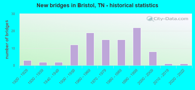
- New bridges - historical statistics
- 31920-1929
- 21930-1939
- 21940-1949
- 121950-1959
- 191960-1969
- 151970-1979
- 151980-1989
- 221990-1999
- 82000-2009
- 12010-2019
- 12020-2022

- Reconstructed bridges - Historical Statistics
- 11960-1969
- 21970-1979
- 31980-1989
- 11990-1999
- 32000-2009


- Bridge Condition - Deck
- 2.2%Excellent
- 8.7%Very good
- 50.0%Good
- 30.4%Satisfactory
- 6.5%Fair
- 2.2%Poor

- Bridge Condition - Superstructure
- 2.1%Excellent
- 8.5%Very good
- 53.2%Good
- 19.1%Satisfactory
- 14.9%Fair
- 2.1%Poor

- Bridge Condition - Substructure
- 2.1%Excellent
- 6.4%Very good
- 55.3%Good
- 12.8%Satisfactory
- 21.3%Fair
- 2.1%Poor

- Bridge Condition - Channel
- 2.8%Very good
- 56.9%Good
- 26.4%Satisfactory
- 12.5%Fair
- 1.4%Poor

- Bridge Condition - Culverts
- 2.8%Very good
- 47.2%Good
- 41.7%Satisfactory
- 8.3%Fair
Find on map >> Show street view
Structure Number: 82SR3940012, Location: IN THE CITY OF BRISTOL (Lat: 36.543067, Lng: -82.172250), Route carried "on" structure: State highway 394, Year Built: 1991, Status: Open, Structure Length: 5.85m (19.19ft), Average Daily Traffic: 6,843 (year 2020), Truck Traffic: 9%, Average Future Daily Traffic: 13,104 (year 2041), Design Load: HS 20, Features Intersected: SR 358
Minimum Vertical Clearance: 30+ m (98+ ft), Kilometerpoint: 22.788, Lanes on structure: 2, Lanes under structure: 2, Base Highway Network: Yes, Owner: State Highway Agency, Approaching Roadway Width: 25.6m (84.0ft), Material/Design: Steel continuous, Design/Construction: Stringer/Multi-beam, Number Of Spans In Main Unit: 3, Length of Maximum Span: 37.5m (123.0ft), Curb-To-Curb Width: 13.0m (42.7ft), Out-to-Out Width: 13.6m (44.6ft)
Condition: Deck: Good, Superstructure: Good, Substructure: Good, Operating Rating: 67.5 metric tons, Method Used To Determine Operating Rating: Load Factor (LF), Inventory Rating: 32.4 metric tons, Method Used To Determine Inventory Rating: Load Factor (LF), Structural Evaluation: Better than present minimum criteria, Deck Geometry: Superior to present desirable criteria, Underclear: Superior to present desirable criteria, Approach Roadway Alignment: Equal to present desirable criteria, Designated Inspection Frequency: Every 24 months, Inspection Date: Febuary 2021, Deck Structure Type: Concrete Precast Panels, Wearing Surface/Protective System: Wearing Surface: Monolithic Concrete, Deck Protection: Epoxy Coated Reinforcing
Find on map >> Show street view
Structure Number: 820A2890001, Location: 3 MI SOUTH OF SR37 (Lat: 36.498700, Lng: -82.301033), Route carried "under" structure: County highway 290, Year Built: 1987, Structure Length: 0. m, Average Daily Traffic: 100 (year 2022), Truck Traffic: 2%, Features Intersected: NFA A289, Facility Carried by Structure: NFA A289
Minimum Vertical Clearance: 3.76m (12.34ft), Kilometerpoint: 0.129, Lanes on structure: 2, Lanes under structure: 1, Material/Design: Prestressed concrete, Design/Construction: Box Beam or Girders - Single/Spread, Length of Maximum Span: 17.1m (56.1ft)
Find on map >> Show street view
Structure Number: 82I00810037, Location: JUST SW OF I81-US11W EXIT (Lat: 36.581667, Lng: -82.266667), Route carried "under" structure: City street 4519, Year Built: 1976, Structure Length: 0. m, Average Daily Traffic: 3,360 (year 2020), Truck Traffic: 3%, Features Intersected: I81 RT LN, Facility Carried by Structure: I81 RT LN
Minimum Vertical Clearance: 5.26m (17.26ft), Kilometerpoint: 1.947, Lanes on structure: 2, Lanes under structure: 2, Material/Design: Prestressed concrete continuous, Design/Construction: Stringer/Multi-beam, Length of Maximum Span: 16.2m (53.1ft)
Find on map >> Show street view
Structure Number: 82I00810038, Location: JUST SW OF I81-US11W EXIT (Lat: 36.581667, Lng: -82.266667), Route carried "under" structure: City street 4519, Year Built: 1979, Structure Length: 0. m, Average Daily Traffic: 3,360 (year 2020), Truck Traffic: 3%, Features Intersected: I81 LF LN, Facility Carried by Structure: I81 LF LN
Minimum Vertical Clearance: 4.80m (15.75ft), Kilometerpoint: 1.980, Lanes on structure: 2, Lanes under structure: 2, Material/Design: Prestressed concrete continuous, Design/Construction: Stringer/Multi-beam, Length of Maximum Span: 16.2m (53.1ft)
Find on map >> Show street view
Structure Number: 82I00810039, Location: JUST W OF BRISTOL (Lat: 36.585000, Lng: -82.261667), Route carried "under" structure: Interstate 81, Year Built: 1960, Structure Length: 0. m, Average Daily Traffic: 31,039 (year 2020), Truck Traffic: 32%, Features Intersected: SR 1, Facility Carried by Structure: FAP 1
Minimum Vertical Clearance: 5.92m (19.42ft), Kilometerpoint: 34.006, Lanes on structure: 2, Lanes under structure: 4, Material/Design: Concrete continuous, Design/Construction: Tee Beam, Length of Maximum Span: 31.4m (103.0ft)
Find on map >> Show street view
Structure Number: 82I0081004, Location: AT VIRGINIA STATE LINE (Lat: 36.585000, Lng: -82.261667), Route carried "under" structure: Interstate 81, Year Built: 1960, Structure Length: 0. m, Average Daily Traffic: 32,517 (year 2020), Truck Traffic: 31%, Features Intersected: SR 1, Facility Carried by Structure: FAP 1
Minimum Vertical Clearance: 4.85m (15.91ft), Kilometerpoint: 34.038, Lanes on structure: 2, Lanes under structure: 4, Material/Design: Concrete continuous, Design/Construction: Tee Beam, Length of Maximum Span: 31.4m (103.0ft)
Find on map >> Show street view
Structure Number: 82S23730005, Location: JUST N OF SR44 (Lat: 36.485817, Lng: -82.200150), Route carried "under" structure: County highway 893, Year Built: 1975, Structure Length: 0. m, Average Daily Traffic: 150 (year 2022), Truck Traffic: 5%, Features Intersected: SR 358, Facility Carried by Structure: FAS 358
Minimum Vertical Clearance: 4.62m (15.16ft), Kilometerpoint: 1.648, Lanes on structure: 2, Lanes under structure: 2, Material/Design: Steel continuous, Design/Construction: Stringer/Multi-beam, Length of Maximum Span: 36.6m (120.1ft)
Find on map >> Show street view
Structure Number: 82SR0340002, Location: SOUTH OF BRISTOL (Lat: 36.469050, Lng: -82.284400), Route carried "under" structure: County highway 2658, Year Built: 1977, Structure Length: 0. m, Average Daily Traffic: 350 (year 2020), Truck Traffic: 3%, Features Intersected: SR 34 LF LN, Facility Carried by Structure: FAP 34
Minimum Vertical Clearance: 8.03m (26.35ft), Kilometerpoint: 5.906, Lanes on structure: 2, Lanes under structure: 2, Material/Design: Steel continuous, Design/Construction: Stringer/Multi-beam, Length of Maximum Span: 85.3m (279.9ft)
Find on map >> Show street view
Structure Number: 82SR0340013, Location: S OF DOWNTOWN BRISTOL (Lat: 36.555800, Lng: -82.215317), Route carried "under" structure: County highway 1378, Year Built: 1963, Structure Length: 0. m, Average Daily Traffic: 7,176 (year 2020), Truck Traffic: 4%, Features Intersected: SR 34, Facility Carried by Structure: FAP 34
Minimum Vertical Clearance: 5.08m (16.67ft), Kilometerpoint: 13.937, Lanes on structure: 2, Lanes under structure: 2, Material/Design: Concrete continuous, Design/Construction: Tee Beam, Length of Maximum Span: 21.9m (71.9ft)
Find on map >> Show street view
Structure Number: 82SR0340033, Location: 2ND STREET (Lat: 36.592167, Lng: -82.183333), Route carried "under" structure: City street 729, Year Built: 2008, Structure Length: 0. m, Average Daily Traffic: 8,550 (year 2018), Truck Traffic: 5%, Features Intersected: SR 473 / A729, Facility Carried by Structure: FAP 473
Minimum Vertical Clearance: 7.57m (24.84ft), Kilometerpoint: 0.338, Lanes on structure: 5, Lanes under structure: 2, Material/Design: Prestressed concrete continuous, Design/Construction: Stringer/Multi-beam, Length of Maximum Span: 25.9m (85.0ft)
Find on map >> Show street view
Structure Number: 82SR0340033, Location: 3RD STREET (Lat: 36.592167, Lng: -82.184167), Route carried "under" structure: City street 730, Year Built: 2008, Structure Length: 0. m, Average Daily Traffic: 8,550 (year 2018), Truck Traffic: 5%, Features Intersected: SR 473 / A730, Facility Carried by Structure: FAP 473
Minimum Vertical Clearance: 5.87m (19.26ft), Kilometerpoint: 0.322, Lanes on structure: 5, Lanes under structure: 2, Material/Design: Prestressed concrete continuous, Design/Construction: Stringer/Multi-beam, Length of Maximum Span: 25.9m (85.0ft)
Find on map >> Show street view
Structure Number: 82SR0340033, Location: BEECHAM STREET (Lat: 36.592167, Lng: -82.186500), Route carried "under" structure: City street 547, Year Built: 2008, Structure Length: 0. m, Average Daily Traffic: 8,550 (year 2018), Truck Traffic: 5%, Features Intersected: SR 473 / A547, Facility Carried by Structure: FAP 473
Minimum Vertical Clearance: 6.80m (22.31ft), Kilometerpoint: 0.145, Lanes on structure: 5, Lanes under structure: 2, Material/Design: Prestressed concrete continuous, Design/Construction: Stringer/Multi-beam, Length of Maximum Span: 25.9m (85.0ft)
Find on map >> Show street view
Structure Number: 82SR1260017, Location: EASTMAN TRUSS WALKWAY (Lat: 36.533711, Lng: -82.551311), Route carried "under" structure: State highway SR126, Year Built: 2016, Structure Length: 0. m, Average Daily Traffic: 12,276 (year 2020), Truck Traffic: 4%, Features Intersected: WILCOX DRIVE
Minimum Vertical Clearance: 5.59m (18.34ft), Kilometerpoint: 3.702, Lanes on structure: 2, Lanes under structure: 2, Material/Design: Steel continuous, Design/Construction: Truss - Thru, Length of Maximum Span: 30.5m (100.1ft)
Find on map >> Show street view
Structure Number: 82SR3580001, Location: JUST OUTSIDE OF BRISTOL (Lat: 36.550883, Lng: -82.177550), Route carried "under" structure: State highway 358, Year Built: 1940, Structure Length: 0. m, Average Daily Traffic: 6,858 (year 2020), Truck Traffic: 4%, Features Intersected: NORFOLK / SOUTHERN RR, Facility Carried by Structure: SOU RR 731106N
Minimum Vertical Clearance: 4.65m (15.26ft), Kilometerpoint: 10.831, Lanes under structure: 2, Material/Design: Prestressed concrete, Design/Construction: Box Beam or Girders - Single/Spread, Length of Maximum Span: 11.9m (39.0ft)
Find on map >> Show street view
Structure Number: 82SR3940009, Location: IN THE CITY OF BRISTOL (Lat: 36.526900, Lng: -82.209600), Route carried "under" structure: County highway 1378, Year Built: 1992, Structure Length: 0. m, Average Daily Traffic: 2,181 (year 2020), Truck Traffic: 3%, Features Intersected: NFA 1378 & SOUTHERN RWY, Facility Carried by Structure: FAP 394
Minimum Vertical Clearance: 7.37m (24.18ft), Kilometerpoint: 6.759, Lanes on structure: 2, Lanes under structure: 2, Material/Design: Prestressed concrete continuous, Design/Construction: Stringer/Multi-beam, Length of Maximum Span: 34.7m (113.8ft)
Find on map >> Show street view
Structure Number: 82SR394001, Location: IN THE CITY OF BRISTOL (Lat: 36.527517, Lng: -82.209450), Route carried "under" structure: County highway 1378, Year Built: 1992, Structure Length: 0. m, Average Daily Traffic: 2,181 (year 2020), Truck Traffic: 3%, Features Intersected: NFA 1378 & SOUTHERN RWY, Facility Carried by Structure: FAP 394
Minimum Vertical Clearance: 7.42m (24.34ft), Kilometerpoint: 6.791, Lanes on structure: 2, Lanes under structure: 2, Material/Design: Prestressed concrete continuous, Design/Construction: Stringer/Multi-beam, Length of Maximum Span: 34.7m (113.8ft)
Find on map >> Show street view
Structure Number: 82SR3940011, Location: IN THE CITY OF BRISTOL (Lat: 36.542950, Lng: -82.172350), Route carried "under" structure: State highway 358, Year Built: 1991, Structure Length: 0. m, Average Daily Traffic: 6,858 (year 2020), Truck Traffic: 4%, Features Intersected: SR 358, Facility Carried by Structure: FAP 394
Minimum Vertical Clearance: 5.13m (16.83ft), Kilometerpoint: 9.817, Lanes on structure: 2, Lanes under structure: 2, Material/Design: Steel continuous, Design/Construction: Stringer/Multi-beam, Length of Maximum Span: 37.5m (123.0ft)
Find on map >> Show street view
Structure Number: 82SR3940012, Location: IN THE CITY OF BRISTOL (Lat: 36.543067, Lng: -82.172250), Route carried "under" structure: State highway 358, Year Built: 1991, Structure Length: 0. m, Average Daily Traffic: 6,858 (year 2020), Truck Traffic: 4%, Features Intersected: SR 358, Facility Carried by Structure: FAP 394
Minimum Vertical Clearance: 5.92m (19.42ft), Kilometerpoint: 9.849, Lanes on structure: 2, Lanes under structure: 2, Material/Design: Steel continuous, Design/Construction: Stringer/Multi-beam, Length of Maximum Span: 37.5m (123.0ft)