Bridge Statistics for Bullhead City, Arizona (AZ)
Condition, Traffic, Stress, Structural Evaluation, Project Costs
- National Bridge Inventory (NBI) Statistics
- 48Number of bridges
- 594ft / 181mTotal length
- $36,000Total costs
- 566,108Total average daily traffic
- 29,883Total average daily truck traffic
- 583,217Total future (year 2034) average daily traffic
- National Bridge Inventory (NBI) Registered Bridges for Bullhead City
- No street view available for this location
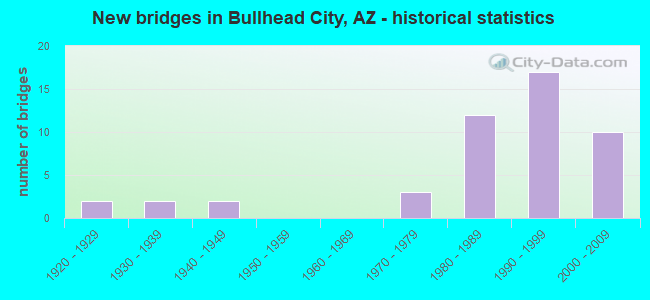
- New bridges - historical statistics
- 21920-1929
- 21930-1939
- 21940-1949
- 31970-1979
- 121980-1989
- 171990-1999
- 102000-2009
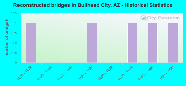
- Reconstructed bridges - Historical Statistics
- 11920-1929
- 01930-1939
- 01940-1949
- 11950-1959
- 01960-1969
- 11970-1979
- 11980-1989
- 11990-1999
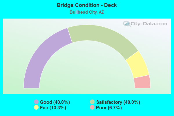
- Bridge Condition - Deck
- 40.0%Good
- 40.0%Satisfactory
- 13.3%Fair
- 6.7%Poor
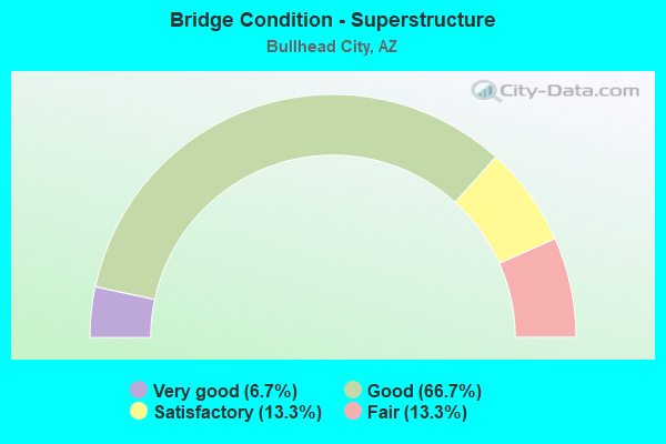
- Bridge Condition - Superstructure
- 6.7%Very good
- 66.7%Good
- 13.3%Satisfactory
- 13.3%Fair
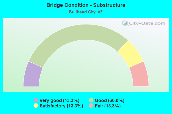
- Bridge Condition - Substructure
- 13.3%Very good
- 60.0%Good
- 13.3%Satisfactory
- 13.3%Fair
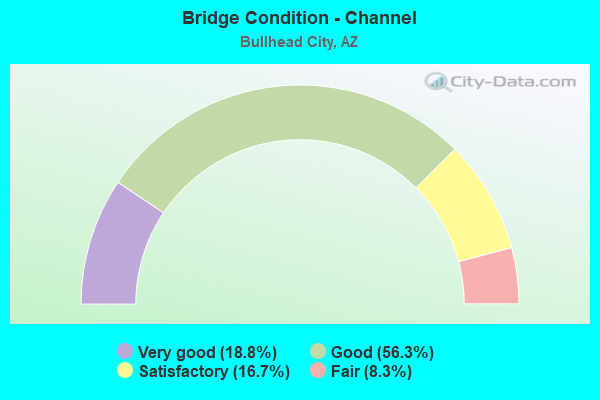
- Bridge Condition - Channel
- 18.8%Very good
- 56.3%Good
- 16.7%Satisfactory
- 8.3%Fair
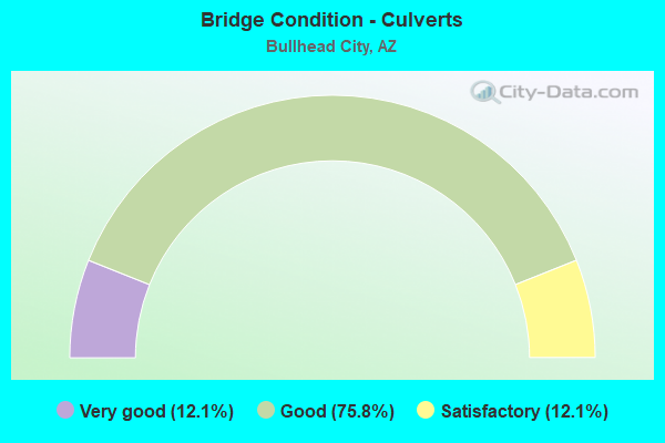
- Bridge Condition - Culverts
- 12.1%Very good
- 75.8%Good
- 12.1%Satisfactory
Find on map >> Show street view
Structure Number: 305-001, Location: Davis Camp (Lat: 35.185600, Lng: -114.568000), Route carried "on" structure: Business Other road , Year Built: 1945, Status: Open, Structure Length: 1.11m (3.64ft), Average Daily Traffic: 40 (year 2019), Average Future Daily Traffic: 40 (year 2039), Features Intersected: Unnamed Arroyo, Facility Carried by Structure: Main Street
Minimum Vertical Clearance: 30+ m (98+ ft), Kilometerpoint: 0.000, Lanes on structure: 2, Owner: Bureau of Reclamation, Approaching Roadway Width: 5.5m (18.0ft), Material/Design: Steel, Design/Construction: Culvert, Number Of Spans In Main Unit: 4, Length of Maximum Span: 2.3m (7.5ft), Curb-To-Curb Width: 7.2m (23.6ft), Out-to-Out Width: 7.2m (23.6ft)
Condition: Channel: Very good, Culverts: Satisfactory, Structural Evaluation: Equal to present minimum criteria, Deck Geometry: Somewhat better than minimum adequacy, Waterway Adequacy: Better than present minimum criteria, Approach Roadway Alignment: Equal to present desirable criteria, Designated Inspection Frequency: Every 24 months, Inspection Date: January 2021
Find on map >> Show street view
Structure Number: 305-3004, Location: 3.5 m N from Bullhead, AZ (Lat: 35.198314, Lng: -114.567542), Route carried "on" structure: Bypass State highway , Year Built: 1949, Status: Open, Structure Length: 16.55m (54.30ft), Average Daily Traffic: 80 (year 2012), Average Future Daily Traffic: 150 (year 2034), Design Load: HS 20, Features Intersected: Forebay Channel, Facility Carried by Structure: Davis Dam Road
Minimum Vertical Clearance: 30+ m (98+ ft), Kilometerpoint: 0.000, Lanes on structure: 2, Owner: Bureau of Reclamation, Approaching Roadway Width: 9.1m (29.9ft), Material/Design: Steel, Design/Construction: Girder and Floorbeam System, Number Of Spans In Main Unit: 2, Number Of Approach Spans: 2, Length of Maximum Span: 64.0m (210.0ft), Curb or Sidewalk Widths: Left: 1.2m (3.9ft), Right: 1.2m (3.9ft), Curb-To-Curb Width: 9.1m (29.9ft), Out-to-Out Width: 12.3m (40.4ft)
Condition: Deck: Fair, Superstructure: Good, Substructure: Good, Channel: Very good, Operating Rating: 47.3 metric tons, Method Used To Determine Operating Rating: Load Factor (LF), Inventory Rating: 28.2 metric tons, Method Used To Determine Inventory Rating: Load Factor (LF), Structural Evaluation: Better than present minimum criteria, Deck Geometry: Better than present minimum criteria, Waterway Adequacy: Superior to present desirable criteria, Approach Roadway Alignment: Equal to present desirable criteria, Designated Inspection Frequency: Every 24 months, Critical Feature Inspection Frequency: Every 24 months, Underwater Inspection Frequency: Every 60 months, Inspection Date: October 2020, Critical Feature Inspection Date: October 2020, Underwater Inspection Date: December 2018, Deck Structure Type: Concrete Cast-file-Place
Find on map >> Show street view
Structure Number: 107, Location: 1.1 mi N Jct SR 82 (Lat: 31.760000, Lng: -110.111100), Route carried "on" structure: State highway 80, Year Built: 1934, Year Reconstructed: 1959, Status: Open, Structure Length: 4.94m (16.21ft), Average Daily Traffic: 3,239 (year 2019), Truck Traffic: 14%, Average Future Daily Traffic: 4,338 (year 2039), Design Load: HS 20, Features Intersected: Willow Gulch
Minimum Vertical Clearance: 30+ m (98+ ft), Kilometerpoint: 503.403, Lanes on structure: 2, Owner: State Highway Agency, Approaching Roadway Width: 10.4m (34.1ft), Material/Design: Concrete, Design/Construction: Tee Beam, Number Of Spans In Main Unit: 4, Length of Maximum Span: 12.2m (40.0ft), Curb-To-Curb Width: 10.4m (34.1ft), Out-to-Out Width: 11.1m (36.4ft)
Condition: Deck: Fair, Superstructure: Fair, Substructure: Fair, Channel: Satisfactory, Operating Rating: 48.1 metric tons, Method Used To Determine Operating Rating: Load Factor (LF), Inventory Rating: 28.1 metric tons, Method Used To Determine Inventory Rating: Load Factor (LF), Structural Evaluation: Somewhat better than minimum adequacy, Deck Geometry: Somewhat better than minimum adequacy, Waterway Adequacy: Equal to present desirable criteria, Approach Roadway Alignment: Equal to present desirable criteria, Designated Inspection Frequency: Every 24 months, Inspection Date: March 2021, Deck Structure Type: Concrete Cast-file-Place, Wearing Surface/Protective System: Wearing Surface: Bituminous
Find on map >> Show street view
Structure Number: 2009, Location: 450 ft N Jct SR 68 (Lat: 35.187800, Lng: -114.551600), Route carried "on" structure: Other road 68, Year Built: 1985, Status: Open, Structure Length: 2.71m (8.89ft), Average Daily Traffic: 1,200 (year 2020), Truck Traffic: 5%, Average Future Daily Traffic: 1,210 (year 2040), Design Load: HS 20, Features Intersected: Arabian Wash
Minimum Vertical Clearance: 30+ m (98+ ft), Kilometerpoint: 2.189, Lanes on structure: 2, Owner: State Highway Agency, Approaching Roadway Width: 13.4m (44.0ft), Material/Design: Prestressed concrete, Design/Construction: Stringer/Multi-beam, Number Of Spans In Main Unit: 1, Length of Maximum Span: 26.2m (86.0ft), Curb-To-Curb Width: 13.4m (44.0ft), Out-to-Out Width: 14.4m (47.2ft)
Condition: Deck: Good, Superstructure: Good, Substructure: Good, Channel: Good, Operating Rating: 89.8 metric tons, Method Used To Determine Operating Rating: Load Factor (LF), Inventory Rating: 55.3 metric tons, Method Used To Determine Inventory Rating: Load Factor (LF), Structural Evaluation: Better than present minimum criteria, Deck Geometry: Equal to present desirable criteria, Waterway Adequacy: Equal to present minimum criteria, Approach Roadway Alignment: Equal to present desirable criteria, Designated Inspection Frequency: Every 24 months, Inspection Date: June 2020, Deck Structure Type: Concrete Cast-file-Place, Wearing Surface/Protective System: Wearing Surface: Monolithic Concrete
Find on map >> Show street view
Structure Number: 2273, Location: 18.2 mi W Jct US 93 (Lat: 35.192600, Lng: -114.441800), Route carried "on" structure: State highway 68, Year Built: 2001, Status: Open, Structure Length: 8.44m (27.69ft), Average Daily Traffic: 4,333 (year 2018), Truck Traffic: 9%, Average Future Daily Traffic: 4,343 (year 2040), Design Load: HS 20, Features Intersected: Arabian Wash
Minimum Vertical Clearance: 30+ m (98+ ft), Kilometerpoint: 12.070, Lanes on structure: 2, Owner: State Highway Agency, Approaching Roadway Width: 12.8m (42.0ft), Skew: 6 degrees, Material/Design: Prestressed concrete continuous, Design/Construction: Stringer/Multi-beam, Number Of Spans In Main Unit: 2, Length of Maximum Span: 40.2m (131.9ft), Curb-To-Curb Width: 12.8m (42.0ft), Out-to-Out Width: 13.7m (44.9ft)
Condition: Deck: Satisfactory, Superstructure: Good, Substructure: Good, Channel: Good, Operating Rating: 89.8 metric tons, Method Used To Determine Operating Rating: Load Factor (LF), Inventory Rating: 39.0 metric tons, Method Used To Determine Inventory Rating: Load Factor (LF), Structural Evaluation: Better than present minimum criteria, Deck Geometry: Equal to present desirable criteria, Waterway Adequacy: Equal to present minimum criteria, Approach Roadway Alignment: Equal to present desirable criteria, Designated Inspection Frequency: Every 24 months, Inspection Date: June 2020, Deck Structure Type: Concrete Cast-file-Place, Wearing Surface/Protective System: Wearing Surface: Monolithic Concrete
Find on map >> Show street view
Structure Number: 2274, Location: 18.2 mi W Jct US 93 (Lat: 35.192500, Lng: -114.442300), Route carried "on" structure: State highway 68, Year Built: 2001, Status: Open, Structure Length: 8.44m (27.69ft), Average Daily Traffic: 4,364 (year 2018), Truck Traffic: 9%, Average Future Daily Traffic: 4,374 (year 2040), Design Load: HS 20, Features Intersected: Arabian Wash
Minimum Vertical Clearance: 30.45m (99.90ft), Kilometerpoint: 12.231, Lanes on structure: 2, Owner: State Highway Agency, Approaching Roadway Width: 12.8m (42.0ft), Skew: 6 degrees, Material/Design: Prestressed concrete continuous, Design/Construction: Stringer/Multi-beam, Number Of Spans In Main Unit: 2, Length of Maximum Span: 40.2m (131.9ft), Curb-To-Curb Width: 12.8m (42.0ft), Out-to-Out Width: 13.7m (44.9ft)
Condition: Deck: Satisfactory, Superstructure: Good, Substructure: Good, Channel: Good, Operating Rating: 89.8 metric tons, Method Used To Determine Operating Rating: Load Factor (LF), Inventory Rating: 34.5 metric tons, Method Used To Determine Inventory Rating: Load Factor (LF), Structural Evaluation: Better than present minimum criteria, Deck Geometry: Equal to present desirable criteria, Waterway Adequacy: Equal to present desirable criteria, Approach Roadway Alignment: Equal to present desirable criteria, Designated Inspection Frequency: Every 24 months, Inspection Date: June 2020, Deck Structure Type: Concrete Cast-file-Place, Wearing Surface/Protective System: Wearing Surface: Monolithic Concrete
Find on map >> Show street view
Structure Number: 2539, Location: Colorado River-Laughlin (Lat: 35.172200, Lng: -114.570600), Route carried "on" structure: State highway 95, Year Built: 1987, Year Reconstructed: 1990, Status: Open, Structure Length: 22.68m (74.41ft), Average Daily Traffic: 32,500 (year 2014), Truck Traffic: 2%, Average Future Daily Traffic: 50,000 (year 2034), Design Load: HS 20, Features Intersected: Colorado River, Facility Carried by Structure: Laughlin Rd Br
Minimum Vertical Clearance: 30+ m (98+ ft), Kilometerpoint: 402.500, Lanes on structure: 4, Owner: State Highway Agency, Approaching Roadway Width: 14.9m (48.9ft), Navigation Control: Yes ( Vertical Clearance: 4.6m (15.1ft), Horizontal Clearance: 36.3m (119.1ft)), Material/Design: Prestressed concrete, Design/Construction: Stringer/Multi-beam, Number Of Spans In Main Unit: 6, Length of Maximum Span: 37.8m (124.0ft), Curb or Sidewalk Widths: Left: 0.0m, Right: 1.6m (5.2ft), Curb-To-Curb Width: 14.9m (48.9ft), Out-to-Out Width: 17.6m (57.7ft)
Condition: Deck: Satisfactory, Superstructure: Good, Substructure: Satisfactory, Channel: Satisfactory, Operating Rating: 37.2 metric tons, Method Used To Determine Operating Rating: Load Factor (LF), Inventory Rating: 22.7 metric tons, Method Used To Determine Inventory Rating: Load Factor (LF), Structural Evaluation: Somewhat better than minimum adequacy, Deck Geometry: High priority of replacement, Waterway Adequacy: Equal to present desirable criteria, Approach Roadway Alignment: Equal to present desirable criteria, Length Of Structure Improvement: 24.11m (79.10ft), Designated Inspection Frequency: Every 24 months, Underwater Inspection Frequency: Every 48 months, Inspection Date: September 2019, Underwater Inspection Date: August 2019, Bridge Improvement Cost: $3,000, Total Project Cost: $4,000 ( Estimate for 2014), Deck Structure Type: Concrete Cast-file-Place, Wearing Surface/Protective System: Wearing Surface: Monolithic Concrete
Find on map >> Show street view
Structure Number: 6646, Location: 5.4 mi South SR 68 (Lat: 35.124444, Lng: -114.579917), Route carried "on" structure: State highway 95, Year Built: 1978, Year Reconstructed: 1983, Status: Open, Structure Length: 0.76m (2.49ft), Average Daily Traffic: 32,600 (year 2014), Truck Traffic: 6%, Average Future Daily Traffic: 32,610 (year 2036), Design Load: HS 20, Features Intersected: Silver Creek
Minimum Vertical Clearance: 30+ m (98+ ft), Kilometerpoint: 396.381, Lanes on structure: 4, Owner: State Highway Agency, Approaching Roadway Width: 20.7m (67.9ft), Material/Design: Concrete continuous, Design/Construction: Culvert, Number Of Spans In Main Unit: 2, Length of Maximum Span: 3.7m (12.1ft), Curb or Sidewalk Widths: Left: 1.8m (5.9ft), Right: 1.8m (5.9ft)
Condition: Channel: Good, Culverts: Satisfactory, Operating Rating: 89.8 metric tons, Method Used To Determine Operating Rating: Load Factor (LF), Inventory Rating: 75.3 metric tons, Method Used To Determine Inventory Rating: Load Factor (LF), Structural Evaluation: Equal to present minimum criteria, Waterway Adequacy: Better than present minimum criteria, Approach Roadway Alignment: Equal to present desirable criteria, Length Of Structure Improvement: 1.49m (4.89ft), Designated Inspection Frequency: Every 48 months, Inspection Date: March 2020, Bridge Improvement Cost: $1,000, Total Project Cost: $2,000 ( Estimate for 2016)
Find on map >> Show street view
Structure Number: 6843, Location: 6.33 mi S Jct SR 68 (Lat: 35.117083, Lng: -114.598083), Route carried "on" structure: State highway 95, Year Built: 1989, Status: Open, Structure Length: 0.88m (2.89ft), Average Daily Traffic: 26,177 (year 2014), Truck Traffic: 6%, Average Future Daily Traffic: 26,187 (year 2036), Design Load: HS 20, Features Intersected: Montana Wash
Minimum Vertical Clearance: 30+ m (98+ ft), Kilometerpoint: 394.402, Lanes on structure: 4, Owner: State Highway Agency, Approaching Roadway Width: 20.7m (67.9ft), Skew: 4 degrees, Material/Design: Concrete continuous, Design/Construction: Culvert, Number Of Spans In Main Unit: 2, Length of Maximum Span: 3.0m (9.8ft)
Condition: Channel: Good, Culverts: Good, Operating Rating: 89.8 metric tons, Method Used To Determine Operating Rating: Load Factor (LF), Inventory Rating: 72.6 metric tons, Method Used To Determine Inventory Rating: Load Factor (LF), Structural Evaluation: Better than present minimum criteria, Waterway Adequacy: Equal to present minimum criteria, Approach Roadway Alignment: Better than present minimum criteria, Length Of Structure Improvement: 1.49m (4.89ft), Designated Inspection Frequency: Every 48 months, Inspection Date: March 2020, Total Project Cost: $2,000 ( Estimate for 2016)
Find on map >> Show street view
Structure Number: 6844, Location: 4.95 mi South of SR 68 (Lat: 35.129750, Lng: -114.574472), Route carried "on" structure: State highway 95, Year Built: 1989, Status: Open, Structure Length: 1.16m (3.81ft), Average Daily Traffic: 32,600 (year 2014), Truck Traffic: 6%, Average Future Daily Traffic: 32,610 (year 2036), Design Load: HS 20, Features Intersected: Dump Wash
Minimum Vertical Clearance: 30+ m (98+ ft), Kilometerpoint: 397.106, Lanes on structure: 4, Owner: State Highway Agency, Approaching Roadway Width: 20.7m (67.9ft), Skew: 2 degrees, Material/Design: Concrete continuous, Design/Construction: Culvert, Number Of Spans In Main Unit: 4, Length of Maximum Span: 2.4m (7.9ft)
Condition: Channel: Fair, Culverts: Good, Operating Rating: 89.8 metric tons, Method Used To Determine Operating Rating: Load Factor (LF), Inventory Rating: 89.8 metric tons, Method Used To Determine Inventory Rating: Load Factor (LF), Structural Evaluation: Better than present minimum criteria, Waterway Adequacy: Somewhat better than minimum adequacy, Approach Roadway Alignment: Equal to present desirable criteria, Length Of Structure Improvement: 1.95m (6.40ft), Designated Inspection Frequency: Every 48 months, Inspection Date: March 2020, Bridge Improvement Cost: $1,000, Total Project Cost: $2,000 ( Estimate for 2016)
Find on map >> Show street view
Structure Number: 6845, Location: 4.60 mi S Jct SR 68 (Lat: 35.134583, Lng: -114.571917), Route carried "on" structure: State highway 95, Year Built: 1989, Status: Open, Structure Length: 3.96m (12.99ft), Average Daily Traffic: 26,676 (year 2014), Truck Traffic: 6%, Average Future Daily Traffic: 26,686 (year 2036), Design Load: HS 20, Features Intersected: Secret Pass Wash
Minimum Vertical Clearance: 30+ m (98+ ft), Kilometerpoint: 397.669, Lanes on structure: 4, Owner: State Highway Agency, Approaching Roadway Width: 20.7m (67.9ft), Material/Design: Concrete continuous, Design/Construction: Culvert, Number Of Spans In Main Unit: 10, Length of Maximum Span: 3.7m (12.1ft)
Condition: Channel: Fair, Culverts: Good, Operating Rating: 89.8 metric tons, Method Used To Determine Operating Rating: Load Factor (LF), Inventory Rating: 89.8 metric tons, Method Used To Determine Inventory Rating: Load Factor (LF), Structural Evaluation: Better than present minimum criteria, Waterway Adequacy: Equal to present desirable criteria, Approach Roadway Alignment: Equal to present desirable criteria, Length Of Structure Improvement: 4.85m (15.91ft), Designated Inspection Frequency: Every 48 months, Inspection Date: March 2020, Bridge Improvement Cost: $1,000, Total Project Cost: $3,000 ( Estimate for 2016)
Find on map >> Show street view
Structure Number: 6846, Location: 4.33 mi S Jct SR 68 (Lat: 35.138056, Lng: -114.570194), Route carried "on" structure: State highway 95, Year Built: 1989, Status: Open, Structure Length: 0.64m (2.10ft), Average Daily Traffic: 26,676 (year 2014), Truck Traffic: 6%, Average Future Daily Traffic: 26,686 (year 2036), Design Load: HS 20, Features Intersected: Boat Ramp Wash
Minimum Vertical Clearance: 30+ m (98+ ft), Kilometerpoint: 398.103, Lanes on structure: 4, Owner: State Highway Agency, Approaching Roadway Width: 20.7m (67.9ft), Skew: 1 degrees, Material/Design: Concrete continuous, Design/Construction: Culvert, Number Of Spans In Main Unit: 2, Length of Maximum Span: 3.0m (9.8ft)
Condition: Channel: Satisfactory, Culverts: Good, Operating Rating: 89.8 metric tons, Method Used To Determine Operating Rating: Load Factor (LF), Inventory Rating: 72.6 metric tons, Method Used To Determine Inventory Rating: Load Factor (LF), Structural Evaluation: Better than present minimum criteria, Waterway Adequacy: Equal to present desirable criteria, Approach Roadway Alignment: Equal to present desirable criteria, Length Of Structure Improvement: 1.37m (4.49ft), Designated Inspection Frequency: Every 48 months, Inspection Date: March 2020, Total Project Cost: $1,000 ( Estimate for 2016)
Find on map >> Show street view
Structure Number: 6859, Location: 1.97 mi S of Jct SR 68 (Lat: 35.171278, Lng: -114.582611), Route carried "on" structure: State highway 95, Year Built: 1989, Status: Open, Structure Length: 3.57m (11.71ft), Average Daily Traffic: 27,135 (year 2014), Truck Traffic: 4%, Average Future Daily Traffic: 27,145 (year 2036), Design Load: HS 20, Features Intersected: Highland Wash
Minimum Vertical Clearance: 30+ m (98+ ft), Kilometerpoint: 401.901, Lanes on structure: 7, Owner: State Highway Agency, Approaching Roadway Width: 27.1m (88.9ft), Material/Design: Concrete continuous, Design/Construction: Culvert, Number Of Spans In Main Unit: 9, Length of Maximum Span: 3.7m (12.1ft), Curb or Sidewalk Widths: Left: 1.7m (5.6ft), Right: 1.7m (5.6ft)
Condition: Channel: Good, Culverts: Good, Operating Rating: 89.8 metric tons, Method Used To Determine Operating Rating: Load Factor (LF), Inventory Rating: 89.8 metric tons, Method Used To Determine Inventory Rating: Load Factor (LF), Structural Evaluation: Better than present minimum criteria, Waterway Adequacy: Equal to present desirable criteria, Approach Roadway Alignment: Equal to present desirable criteria, Length Of Structure Improvement: 4.42m (14.50ft), Designated Inspection Frequency: Every 48 months, Inspection Date: March 2020, Bridge Improvement Cost: $1,000, Roadway Improvement Cost: $1,000, Total Project Cost: $2,000 ( Estimate for 2016)
Find on map >> Show street view
Structure Number: 686, Location: 1.77 mi S Jct SR 68 (Lat: 35.173944, Lng: -114.565778), Route carried "on" structure: State highway 95, Year Built: 1989, Status: Open, Structure Length: 1.04m (3.41ft), Average Daily Traffic: 26,440 (year 2014), Truck Traffic: 6%, Average Future Daily Traffic: 26,450 (year 2036), Design Load: HS 20, Features Intersected: Highland Wash
Minimum Vertical Clearance: 30+ m (98+ ft), Kilometerpoint: 402.223, Lanes on structure: 4, Owner: State Highway Agency, Approaching Roadway Width: 20.7m (67.9ft), Material/Design: Concrete continuous, Design/Construction: Culvert, Number Of Spans In Main Unit: 4, Length of Maximum Span: 2.4m (7.9ft), Curb or Sidewalk Widths: Left: 0.2m (0.7ft), Right: 1.7m (5.6ft)
Condition: Channel: Satisfactory, Culverts: Good, Operating Rating: 89.8 metric tons, Method Used To Determine Operating Rating: Load Factor (LF), Inventory Rating: 89.8 metric tons, Method Used To Determine Inventory Rating: Load Factor (LF), Structural Evaluation: Better than present minimum criteria, Waterway Adequacy: Equal to present minimum criteria, Approach Roadway Alignment: Equal to present desirable criteria, Length Of Structure Improvement: 1.83m (6.00ft), Designated Inspection Frequency: Every 48 months, Inspection Date: March 2020, Total Project Cost: $1,000 ( Estimate for 2016)
Find on map >> Show street view
Structure Number: 7061, Location: 9.02 mi S Jct SR 68 (Lat: 35.054900, Lng: -114.589200), Route carried "on" structure: State highway 95, Year Built: 1999, Status: Open, Structure Length: 2.71m (8.89ft), Average Daily Traffic: 29,640 (year 2014), Truck Traffic: 6%, Average Future Daily Traffic: 29,650 (year 2036), Design Load: HS 20, Features Intersected: Wash
Minimum Vertical Clearance: 30+ m (98+ ft), Kilometerpoint: 387.176, Lanes on structure: 6, Owner: State Highway Agency, Approaching Roadway Width: 25.0m (82.0ft), Skew: 1 degrees, Material/Design: Concrete continuous, Design/Construction: Culvert, Number Of Spans In Main Unit: 8, Length of Maximum Span: 3.0m (9.8ft)
Condition: Channel: Good, Culverts: Good, Operating Rating: 89.8 metric tons, Method Used To Determine Operating Rating: Load Factor (LF), Inventory Rating: 81.6 metric tons, Method Used To Determine Inventory Rating: Load Factor (LF), Structural Evaluation: Better than present minimum criteria, Waterway Adequacy: Equal to present desirable criteria, Approach Roadway Alignment: Equal to present desirable criteria, Length Of Structure Improvement: 3.54m (11.61ft), Designated Inspection Frequency: Every 48 months, Inspection Date: March 2020, Bridge Improvement Cost: $1,000, Total Project Cost: $2,000 ( Estimate for 2016)
Find on map >> Show street view
Structure Number: 7062, Location: 9.0 mi S Jct SR 68 (Lat: 35.055300, Lng: -114.589200), Route carried "on" structure: State highway 95, Year Built: 1999, Status: Open, Structure Length: 1.98m (6.50ft), Average Daily Traffic: 29,640 (year 2014), Truck Traffic: 6%, Average Future Daily Traffic: 29,650 (year 2036), Design Load: HS 20, Features Intersected: Wash
Minimum Vertical Clearance: 30+ m (98+ ft), Kilometerpoint: 387.208, Lanes on structure: 9, Owner: State Highway Agency, Approaching Roadway Width: 32.9m (107.9ft), Material/Design: Concrete continuous, Design/Construction: Culvert, Number Of Spans In Main Unit: 6, Length of Maximum Span: 3.0m (9.8ft)
Condition: Channel: Good, Culverts: Good, Operating Rating: 89.8 metric tons, Method Used To Determine Operating Rating: Load Factor (LF), Inventory Rating: 81.6 metric tons, Method Used To Determine Inventory Rating: Load Factor (LF), Structural Evaluation: Better than present minimum criteria, Waterway Adequacy: Equal to present desirable criteria, Approach Roadway Alignment: Equal to present desirable criteria, Length Of Structure Improvement: 3.41m (11.19ft), Designated Inspection Frequency: Every 48 months, Inspection Date: March 2020, Bridge Improvement Cost: $1,000, Roadway Improvement Cost: $1,000, Total Project Cost: $3,000 ( Estimate for 2016)
Find on map >> Show street view
Structure Number: 7063, Location: 8.6 mi S Jct SR 68 (Lat: 35.061833, Lng: -114.589194), Route carried "on" structure: State highway 95, Year Built: 1999, Status: Open, Structure Length: 0.98m (3.22ft), Average Daily Traffic: 26,556 (year 2014), Truck Traffic: 6%, Average Future Daily Traffic: 26,566 (year 2036), Design Load: HS 20, Features Intersected: Wash
Minimum Vertical Clearance: 30+ m (98+ ft), Kilometerpoint: 387.997, Lanes on structure: 5, Owner: State Highway Agency, Approaching Roadway Width: 24.1m (79.1ft), Material/Design: Concrete continuous, Design/Construction: Culvert, Number Of Spans In Main Unit: 3, Length of Maximum Span: 3.0m (9.8ft)
Condition: Channel: Good, Culverts: Good, Operating Rating: 89.8 metric tons, Method Used To Determine Operating Rating: Load Factor (LF), Inventory Rating: 75.3 metric tons, Method Used To Determine Inventory Rating: Load Factor (LF), Structural Evaluation: Better than present minimum criteria, Waterway Adequacy: Equal to present desirable criteria, Approach Roadway Alignment: Equal to present desirable criteria, Length Of Structure Improvement: 1.77m (5.81ft), Designated Inspection Frequency: Every 48 months, Inspection Date: March 2020, Total Project Cost: $2,000 ( Estimate for 2016)
Find on map >> Show street view
Structure Number: 7064, Location: 8.4 mi S Jct SR 68 (Lat: 35.064700, Lng: -114.589200), Route carried "on" structure: State highway 95, Year Built: 1999, Status: Open, Structure Length: 1.65m (5.41ft), Average Daily Traffic: 26,556 (year 2014), Truck Traffic: 6%, Average Future Daily Traffic: 26,566 (year 2036), Design Load: HS 20, Features Intersected: Wash
Minimum Vertical Clearance: 30+ m (98+ ft), Kilometerpoint: 388.319, Lanes on structure: 4, Owner: State Highway Agency, Approaching Roadway Width: 20.7m (67.9ft), Material/Design: Concrete continuous, Design/Construction: Culvert, Number Of Spans In Main Unit: 5, Length of Maximum Span: 3.0m (9.8ft)
Condition: Channel: Good, Culverts: Good, Operating Rating: 89.8 metric tons, Method Used To Determine Operating Rating: Load Factor (LF), Inventory Rating: 89.8 metric tons, Method Used To Determine Inventory Rating: Load Factor (LF), Structural Evaluation: Better than present minimum criteria, Waterway Adequacy: Equal to present desirable criteria, Approach Roadway Alignment: Equal to present desirable criteria, Length Of Structure Improvement: 2.41m (7.91ft), Designated Inspection Frequency: Every 48 months, Inspection Date: March 2020, Bridge Improvement Cost: $1,000, Total Project Cost: $2,000 ( Estimate for 2016)
Find on map >> Show street view
Structure Number: 7065, Location: 8.2 mi S Jct SR 68 (Lat: 35.067500, Lng: -114.589200), Route carried "on" structure: State highway 95, Year Built: 1999, Status: Open, Structure Length: 1.04m (3.41ft), Average Daily Traffic: 26,859 (year 2014), Truck Traffic: 6%, Average Future Daily Traffic: 25,869 (year 2036), Design Load: HS 20, Features Intersected: Wash
Minimum Vertical Clearance: 30+ m (98+ ft), Kilometerpoint: 388.592, Lanes on structure: 4, Owner: State Highway Agency, Approaching Roadway Width: 20.7m (67.9ft), Skew: 4 degrees, Material/Design: Concrete continuous, Design/Construction: Culvert, Number Of Spans In Main Unit: 4, Length of Maximum Span: 2.4m (7.9ft)
Condition: Channel: Very good, Culverts: Good, Operating Rating: 89.8 metric tons, Method Used To Determine Operating Rating: Load Factor (LF), Inventory Rating: 89.8 metric tons, Method Used To Determine Inventory Rating: Load Factor (LF), Structural Evaluation: Better than present minimum criteria, Waterway Adequacy: Equal to present desirable criteria, Approach Roadway Alignment: Superior to present desirable criteria, Length Of Structure Improvement: 1.80m (5.91ft), Designated Inspection Frequency: Every 48 months, Inspection Date: March 2020, Bridge Improvement Cost: $1,000, Total Project Cost: $2,000 ( Estimate for 2016)
Find on map >> Show street view
Structure Number: 7066, Location: 6.9 mi S Jct SR 68 (Lat: 35.084300, Lng: -114.597700), Route carried "on" structure: State highway 95, Year Built: 1999, Status: Open, Structure Length: 0.64m (2.10ft), Average Daily Traffic: 26,859 (year 2014), Truck Traffic: 6%, Average Future Daily Traffic: 26,869 (year 2036), Design Load: HS 20, Features Intersected: Wash
Minimum Vertical Clearance: 30+ m (98+ ft), Kilometerpoint: 390.684, Lanes on structure: 6, Owner: State Highway Agency, Approaching Roadway Width: 20.7m (67.9ft), Skew: 2 degrees, Material/Design: Concrete continuous, Design/Construction: Culvert, Number Of Spans In Main Unit: 2, Length of Maximum Span: 3.0m (9.8ft)
Condition: Channel: Very good, Culverts: Good, Operating Rating: 89.8 metric tons, Method Used To Determine Operating Rating: Load Factor (LF), Inventory Rating: 89.8 metric tons, Method Used To Determine Inventory Rating: Load Factor (LF), Structural Evaluation: Better than present minimum criteria, Waterway Adequacy: Equal to present desirable criteria, Approach Roadway Alignment: Equal to present desirable criteria, Designated Inspection Frequency: Every 48 months, Inspection Date: March 2020
Find on map >> Show street view
Structure Number: 7067, Location: 6.9 mi S Jct SR 68 (Lat: 35.084833, Lng: -114.597611), Route carried "on" structure: State highway 95, Year Built: 1999, Status: Open, Structure Length: 1.07m (3.51ft), Average Daily Traffic: 26,859 (year 2014), Truck Traffic: 6%, Average Future Daily Traffic: 25,869 (year 2036), Design Load: HS 20, Features Intersected: Wash
Minimum Vertical Clearance: 30+ m (98+ ft), Kilometerpoint: 390.717, Lanes on structure: 5, Owner: State Highway Agency, Approaching Roadway Width: 20.7m (67.9ft), Skew: 4 degrees, Material/Design: Concrete continuous, Design/Construction: Culvert, Number Of Spans In Main Unit: 2, Length of Maximum Span: 3.7m (12.1ft)
Condition: Channel: Very good, Culverts: Good, Operating Rating: 89.8 metric tons, Method Used To Determine Operating Rating: Load Factor (LF), Inventory Rating: 72.6 metric tons, Method Used To Determine Inventory Rating: Load Factor (LF), Structural Evaluation: Better than present minimum criteria, Waterway Adequacy: Equal to present desirable criteria, Approach Roadway Alignment: Better than present minimum criteria, Designated Inspection Frequency: Every 48 months, Inspection Date: March 2020
Find on map >> Show street view
Structure Number: 7068, Location: 16.8 mi N of Needles Br (Lat: 35.086028, Lng: -114.597639), Route carried "on" structure: ServiceState highway 95, Year Built: 1999, Status: Open, Structure Length: 0.76m (2.49ft), Average Daily Traffic: 600 (year 2016), Truck Traffic: 5%, Average Future Daily Traffic: 610 (year 2036), Design Load: HS 20, Features Intersected: Wash, Facility Carried by Structure: Marble Canyon Dr
Minimum Vertical Clearance: 30+ m (98+ ft), Kilometerpoint: 390.910, Lanes on structure: 3, Owner: State Highway Agency, Approaching Roadway Width: 10.4m (34.1ft), Material/Design: Concrete continuous, Design/Construction: Culvert, Number Of Spans In Main Unit: 2, Length of Maximum Span: 3.7m (12.1ft)
Condition: Channel: Very good, Culverts: Good, Operating Rating: 68.0 metric tons, Method Used To Determine Operating Rating: Load Factor (LF), Inventory Rating: 39.9 metric tons, Method Used To Determine Inventory Rating: Load Factor (LF), Structural Evaluation: Better than present minimum criteria, Waterway Adequacy: Equal to present desirable criteria, Approach Roadway Alignment: Equal to present desirable criteria, Designated Inspection Frequency: Every 48 months, Inspection Date: March 2020
Find on map >> Show street view
Structure Number: 7095, Location: 18.8 mi W of US 93 (Lat: 35.196361, Lng: -114.448944), Route carried "on" structure: State highway 68, Year Built: 2001, Status: Open, Structure Length: 1.37m (4.49ft), Average Daily Traffic: 14,276 (year 2018), Truck Traffic: 18%, Average Future Daily Traffic: 14,286 (year 2036), Design Load: HS 20, Features Intersected: Arabian Wash
Minimum Vertical Clearance: 30.45m (99.90ft), Kilometerpoint: 13.036, Lanes on structure: 5, Owner: State Highway Agency, Approaching Roadway Width: 31.1m (102.0ft), Skew: 24 degrees, Material/Design: Concrete continuous, Design/Construction: Culvert, Number Of Spans In Main Unit: 3, Length of Maximum Span: 3.0m (9.8ft)
Condition: Channel: Good, Culverts: Good, Operating Rating: 89.8 metric tons, Method Used To Determine Operating Rating: Load Factor (LF), Inventory Rating: 89.8 metric tons, Method Used To Determine Inventory Rating: Load Factor (LF), Structural Evaluation: Better than present minimum criteria, Waterway Adequacy: Equal to present desirable criteria, Approach Roadway Alignment: Equal to present desirable criteria, Length Of Structure Improvement: 2.13m (6.99ft), Designated Inspection Frequency: Every 48 months, Inspection Date: April 2020, Bridge Improvement Cost: $2,000, Roadway Improvement Cost: $1,000, Total Project Cost: $4,000 ( Estimate for 2016)
Find on map >> Show street view
Structure Number: 8658, Location: 120 ft E Jct 2nd St (Lat: 34.746800, Lng: -112.025200), Route carried "on" structure: City street , Year Built: 1936, Status: Open, Structure Length: 1.01m (3.31ft), Average Daily Traffic: 660 (year 2020), Truck Traffic: 1%, Average Future Daily Traffic: 670 (year 2040), Design Load: H 15, Features Intersected: Blowout Wash, Facility Carried by Structure: Pima Street
Minimum Vertical Clearance: 6.10m (20.01ft), Kilometerpoint: 0.000, Lanes on structure: 1, Owner: City or Municipal Highway Agency, Approaching Roadway Width: 5.8m (19.0ft), Material/Design: Steel, Design/Construction: Stringer/Multi-beam, Number Of Spans In Main Unit: 1, Length of Maximum Span: 9.4m (30.8ft), Curb or Sidewalk Widths: Left: 0.1m (0.3ft), Right: 0.1m (0.3ft), Curb-To-Curb Width: 5.8m (19.0ft), Out-to-Out Width: 6.1m (20.0ft)
Condition: Deck: Poor, Superstructure: Satisfactory, Substructure: Satisfactory, Channel: Satisfactory, Operating Rating: 36.3 metric tons, Method Used To Determine Operating Rating: Field evaluation and documented engineering judgment, Inventory Rating: 21.8 metric tons, Method Used To Determine Inventory Rating: Field evaluation and documented engineering judgment, Structural Evaluation: Somewhat better than minimum adequacy, Deck Geometry: High priority of replacement, Waterway Adequacy: Meets minimum limits, Approach Roadway Alignment: Equal to present minimum criteria, Length Of Structure Improvement: 1.01m (3.31ft), Designated Inspection Frequency: Every 24 months, Inspection Date: July 2020, Deck Structure Type: Concrete Cast-file-Place, Wearing Surface/Protective System: Wearing Surface: Monolithic Concrete
Find on map >> Show street view
Structure Number: 8659, Location: 1.7 mi SW Jct I 15 (Lat: 36.875600, Lng: -113.949400), Route carried "on" structure: County highway , Year Built: 1929, Year Reconstructed: 1932, Status: Open, Structure Length: 0.64m (2.10ft), Average Daily Traffic: 659 (year 2016), Truck Traffic: 1%, Average Future Daily Traffic: 669 (year 2036), Design Load: H 15, Features Intersected: Wash, Facility Carried by Structure: Old US 91
Minimum Vertical Clearance: 30+ m (98+ ft), Kilometerpoint: 12.080, Lanes on structure: 2, Owner: County Highway Agency, Approaching Roadway Width: 7.3m (24.0ft), Material/Design: Concrete continuous, Design/Construction: Culvert, Number Of Spans In Main Unit: 2, Length of Maximum Span: 3.0m (9.8ft), Curb or Sidewalk Widths: Left: 0.2m (0.7ft), Right: 0.2m (0.7ft), Curb-To-Curb Width: 7.3m (24.0ft), Out-to-Out Width: 7.8m (25.6ft)
Condition: Channel: Satisfactory, Culverts: Satisfactory, Operating Rating: 53.5 metric tons, Method Used To Determine Operating Rating: Load Factor (LF), Inventory Rating: 31.8 metric tons, Method Used To Determine Inventory Rating: Load Factor (LF), Structural Evaluation: Equal to present minimum criteria, Deck Geometry: Meets minimum limits, Waterway Adequacy: Equal to present minimum criteria, Approach Roadway Alignment: Equal to present desirable criteria, Designated Inspection Frequency: Every 24 months, Inspection Date: September 2021, Deck Structure Type: Concrete Cast-file-Place, Wearing Surface/Protective System: Wearing Surface: Bituminous
Find on map >> Show street view
Structure Number: 8661, Location: 0.3 mi E Jct US 70 (Lat: 32.961800, Lng: -109.915300), Route carried "on" structure: County highway , Year Built: 1983, Status: Open, Structure Length: 12.34m (40.49ft), Average Daily Traffic: 250 (year 2019), Truck Traffic: 5%, Average Future Daily Traffic: 260 (year 2039), Design Load: HS 20, Features Intersected: Gila River, Facility Carried by Structure: Eden Road
Minimum Vertical Clearance: 30+ m (98+ ft), Kilometerpoint: 0.000, Lanes on structure: 2, Owner: County Highway Agency, Approaching Roadway Width: 9.1m (29.9ft), Material/Design: Prestressed concrete continuous, Design/Construction: Stringer/Multi-beam, Number Of Spans In Main Unit: 4, Length of Maximum Span: 30.8m (101.0ft), Curb-To-Curb Width: 9.1m (29.9ft), Out-to-Out Width: 10.1m (33.1ft)
Condition: Deck: Good, Superstructure: Very good, Substructure: Very good, Channel: Good, Operating Rating: 84.4 metric tons, Method Used To Determine Operating Rating: Load Factor (LF), Inventory Rating: 34.5 metric tons, Method Used To Determine Inventory Rating: Load Factor (LF), Structural Evaluation: Equal to present desirable criteria, Deck Geometry: Equal to present minimum criteria, Waterway Adequacy: Better than present minimum criteria, Approach Roadway Alignment: Equal to present desirable criteria, Designated Inspection Frequency: Every 24 months, Inspection Date: August 2021, Deck Structure Type: Concrete Cast-file-Place, Wearing Surface/Protective System: Wearing Surface: Monolithic Concrete
Find on map >> Show street view
Structure Number: 8662, Location: 2.9 mi E of Az State Ln (Lat: 36.828275, Lng: -114.000806), Route carried "on" structure: County highway , Year Built: 1929, Status: Posted for load, Structure Length: 11.28m (37.01ft), Average Daily Traffic: 320 (year 2019), Truck Traffic: 1%, Average Future Daily Traffic: 330 (year 2039), Design Load: H 15, Features Intersected: Sand Hollow Wash, Facility Carried by Structure: Old Hwy 91
Minimum Vertical Clearance: 30+ m (98+ ft), Kilometerpoint: 0.000, Lanes on structure: 2, Owner: County Highway Agency, Approaching Roadway Width: 6.1m (20.0ft), Material/Design: Steel, Design/Construction: Truss - Deck, Number Of Spans In Main Unit: 2, Number Of Approach Spans: 4, Length of Maximum Span: 24.4m (80.1ft), Curb or Sidewalk Widths: Left: 0.2m (0.7ft), Right: 0.2m (0.7ft), Curb-To-Curb Width: 6.1m (20.0ft), Out-to-Out Width: 6.4m (21.0ft)
Condition: Deck: Satisfactory, Superstructure: Fair, Substructure: Fair, Channel: Satisfactory, Operating Rating: 43.5 metric tons, Method Used To Determine Operating Rating: Load Factor (LF), Inventory Rating: 27.2 metric tons, Method Used To Determine Inventory Rating: Load Factor (LF), Structural Evaluation: Somewhat better than minimum adequacy, Deck Geometry: Meets minimum limits, Waterway Adequacy: Better than present minimum criteria, Approach Roadway Alignment: Meets minimum limits, Length Of Structure Improvement: 12.34m (40.49ft), Designated Inspection Frequency: Every 24 months, Critical Feature Inspection Frequency: Every 24 months, Inspection Date: July 2021, Critical Feature Inspection Date: July 2021, Bridge Improvement Cost: $1,000, Total Project Cost: $1,000 ( Estimate for 2021), Deck Structure Type: Concrete Cast-file-Place, Wearing Surface/Protective System: Wearing Surface: Monolithic Concrete
Find on map >> Show street view
Structure Number: 8664, Location: 0.1 mi S of Baseline Rd (Lat: 33.376600, Lng: -111.919300), Route carried "on" structure: City street , Year Built: 1971, Status: Open, Structure Length: 2.32m (7.61ft), Average Daily Traffic: 1,195 (year 2019), Truck Traffic: 5%, Average Future Daily Traffic: 1,205 (year 2039), Design Load: HS 20, Features Intersected: The Lakes, Facility Carried by Structure: Lakeshore Drive
Minimum Vertical Clearance: 30+ m (98+ ft), Kilometerpoint: 0.000, Lanes on structure: 2, Owner: City or Municipal Highway Agency, Approaching Roadway Width: 15.8m (51.8ft), Skew: 20 degrees, Material/Design: Prestressed concrete, Design/Construction: Tee Beam, Number Of Spans In Main Unit: 1, Length of Maximum Span: 22.3m (73.2ft), Curb or Sidewalk Widths: Left: 2.0m (6.6ft), Right: 1.5m (4.9ft), Curb-To-Curb Width: 15.1m (49.5ft), Out-to-Out Width: 19.4m (63.6ft)
Condition: Deck: Satisfactory, Superstructure: Good, Substructure: Good, Channel: Good, Operating Rating: 49.9 metric tons, Method Used To Determine Operating Rating: Load Factor (LF), Inventory Rating: 19.1 metric tons, Method Used To Determine Inventory Rating: Load Factor (LF), Structural Evaluation: Somewhat better than minimum adequacy, Deck Geometry: Superior to present desirable criteria, Waterway Adequacy: Equal to present desirable criteria, Approach Roadway Alignment: Better than present minimum criteria, Length Of Structure Improvement: 3.11m (10.20ft), Designated Inspection Frequency: Every 24 months, Inspection Date: August 2021, Total Project Cost: $1,000 ( Estimate for 2019), Deck Structure Type: Concrete Cast-file-Place, Wearing Surface/Protective System: Wearing Surface: Monolithic Concrete
Find on map >> Show street view
Structure Number: 8665, Location: 0.25 mi W of Rural Road (Lat: 33.356600, Lng: -111.931700), Route carried "on" structure: City street , Year Built: 1974, Status: Open, Structure Length: 1.28m (4.20ft), Average Daily Traffic: 250 (year 2018), Truck Traffic: 1%, Average Future Daily Traffic: 260 (year 2038), Design Load: HS 20, Features Intersected: Western Canal, Facility Carried by Structure: Muni Golf Cse Rd
Minimum Vertical Clearance: 6.10m (20.01ft), Kilometerpoint: 0.000, Lanes on structure: 2, Owner: City or Municipal Highway Agency, Approaching Roadway Width: 7.3m (24.0ft), Material/Design: Concrete continuous, Design/Construction: Slab, Number Of Spans In Main Unit: 2, Length of Maximum Span: 6.4m (21.0ft), Curb-To-Curb Width: 7.3m (24.0ft), Out-to-Out Width: 8.0m (26.2ft)
Condition: Deck: Satisfactory, Superstructure: Satisfactory, Substructure: Very good, Channel: Very good, Operating Rating: 48.1 metric tons, Method Used To Determine Operating Rating: Load Factor (LF), Inventory Rating: 28.1 metric tons, Method Used To Determine Inventory Rating: Load Factor (LF), Structural Evaluation: Equal to present minimum criteria, Deck Geometry: Somewhat better than minimum adequacy, Waterway Adequacy: Better than present minimum criteria, Approach Roadway Alignment: Equal to present desirable criteria, Designated Inspection Frequency: Every 24 months, Underwater Inspection Frequency: Every 60 months, Inspection Date: January 2022, Underwater Inspection Date: December 2019, Deck Structure Type: Concrete Cast-file-Place, Wearing Surface/Protective System: Wearing Surface: Monolithic Concrete
Find on map >> Show street view
Structure Number: 8666, Location: 8.7 mi S Jct SR 69 (Lat: 34.451972, Lng: -112.387667), Route carried "on" structure: County highway , Year Built: 1982, Status: Open, Structure Length: 0.64m (2.10ft), Average Daily Traffic: 199 (year 2019), Average Future Daily Traffic: 209 (year 2039), Design Load: HS 20, Features Intersected: Lynx Creek, Facility Carried by Structure: Walker Road
Minimum Vertical Clearance: 30+ m (98+ ft), Kilometerpoint: 0.000, Lanes on structure: 2, Owner: County Highway Agency, Approaching Roadway Width: 10.1m (33.1ft), Material/Design: Concrete continuous, Design/Construction: Culvert, Number Of Spans In Main Unit: 2, Length of Maximum Span: 3.0m (9.8ft), Curb or Sidewalk Widths: Left: 0.3m (1.0ft), Right: 0.3m (1.0ft), Curb-To-Curb Width: 10.0m (32.8ft), Out-to-Out Width: 10.6m (34.8ft)
Condition: Channel: Very good, Culverts: Satisfactory, Operating Rating: 53.5 metric tons, Method Used To Determine Operating Rating: Load Factor (LF), Inventory Rating: 31.8 metric tons, Method Used To Determine Inventory Rating: Load Factor (LF), Structural Evaluation: Equal to present minimum criteria, Deck Geometry: Better than present minimum criteria, Waterway Adequacy: Equal to present desirable criteria, Approach Roadway Alignment: Equal to present minimum criteria, Designated Inspection Frequency: Every 48 months, Inspection Date: August 2019, Deck Structure Type: Concrete Cast-file-Place, Wearing Surface/Protective System: Wearing Surface: Monolithic Concrete
Find on map >> Show street view
Structure Number: 8668, Location: Ave 64 E & 4 1/4 St N (Lat: 32.880306, Lng: -113.541194), Route carried "on" structure: County highway , Year Built: 1982, Year Reconstructed: 1993, Status: Open, Structure Length: 22.47m (73.72ft), Average Daily Traffic: 703 (year 2015), Truck Traffic: 1%, Average Future Daily Traffic: 713 (year 2035), Design Load: HS 20, Features Intersected: Gila River, Facility Carried by Structure: Avenue 64E
Minimum Vertical Clearance: 30+ m (98+ ft), Kilometerpoint: 0.000, Lanes on structure: 2, Owner: County Highway Agency, Approaching Roadway Width: 7.3m (24.0ft), Skew: 1 degrees, Material/Design: Prestressed concrete, Design/Construction: Box Beam or Girders - Multiple, Number Of Spans In Main Unit: 11, Length of Maximum Span: 21.3m (69.9ft), Curb-To-Curb Width: 9.0m (29.5ft), Out-to-Out Width: 9.8m (32.2ft)
Condition: Deck: Good, Superstructure: Good, Substructure: Good, Channel: Good, Operating Rating: 78.0 metric tons, Method Used To Determine Operating Rating: Load Factor (LF), Inventory Rating: 36.3 metric tons, Method Used To Determine Inventory Rating: Load Factor (LF), Structural Evaluation: Better than present minimum criteria, Deck Geometry: Somewhat better than minimum adequacy, Waterway Adequacy: Equal to present desirable criteria, Approach Roadway Alignment: Equal to present desirable criteria, Designated Inspection Frequency: Every 24 months, Inspection Date: January 2021, Deck Structure Type: Concrete Precast Panels, Wearing Surface/Protective System: Wearing Surface: Bituminous
Find on map >> Show street view
Structure Number: 8669, Location: 0.24 mi S of Shea Blvd (Lat: 33.579800, Lng: -111.858800), Route carried "on" structure: City street , Year Built: 1980, Status: Open, Structure Length: 1.16m (3.81ft), Average Daily Traffic: 1,550 (year 2020), Truck Traffic: 5%, Average Future Daily Traffic: 1,560 (year 2040), Design Load: HS 20, Features Intersected: Sctsdl Ranch Lake, Facility Carried by Structure: Lakeview Drive
Minimum Vertical Clearance: 30+ m (98+ ft), Kilometerpoint: 0.000, Lanes on structure: 2, Owner: City or Municipal Highway Agency, Approaching Roadway Width: 12.2m (40.0ft), Material/Design: Concrete, Design/Construction: Slab, Number Of Spans In Main Unit: 1, Length of Maximum Span: 11.6m (38.1ft), Curb or Sidewalk Widths: Left: 1.7m (5.6ft), Right: 2.6m (8.5ft), Curb-To-Curb Width: 12.2m (40.0ft), Out-to-Out Width: 17.8m (58.4ft)
Condition: Deck: Good, Superstructure: Good, Substructure: Good, Channel: Very good, Operating Rating: 74.4 metric tons, Method Used To Determine Operating Rating: Load Factor (LF), Inventory Rating: 44.5 metric tons, Method Used To Determine Inventory Rating: Load Factor (LF), Structural Evaluation: Better than present minimum criteria, Deck Geometry: Better than present minimum criteria, Waterway Adequacy: Equal to present desirable criteria, Approach Roadway Alignment: Equal to present desirable criteria, Designated Inspection Frequency: Every 24 months, Inspection Date: January 2022, Deck Structure Type: Concrete Cast-file-Place, Wearing Surface/Protective System: Wearing Surface: Bituminous
Find on map >> Show street view
Structure Number: 10171, Location: 0.2 mi N Jct Mohave Dr (Lat: 35.083278, Lng: -114.604444), Route carried "on" structure: City street , Year Built: 1999, Status: Open, Structure Length: 1.49m (4.89ft), Average Daily Traffic: 14,276 (year 2018), Truck Traffic: 2%, Average Future Daily Traffic: 14,286 (year 2036), Design Load: HS 20, Features Intersected: Wash, Facility Carried by Structure: Country Club Drive
Minimum Vertical Clearance: 30+ m (98+ ft), Kilometerpoint: 0.000, Lanes on structure: 2, Owner: City or Municipal Highway Agency, Approaching Roadway Width: 11.6m (38.1ft), Material/Design: Concrete continuous, Design/Construction: Culvert, Number Of Spans In Main Unit: 4, Length of Maximum Span: 3.7m (12.1ft), Curb or Sidewalk Widths: Left: 1.4m (4.6ft), Right: 1.4m (4.6ft), Curb-To-Curb Width: 11.6m (38.1ft), Out-to-Out Width: 14.6m (47.9ft)
Condition: Channel: Good, Culverts: Good, Operating Rating: 53.5 metric tons, Method Used To Determine Operating Rating: Load Factor (LF), Inventory Rating: 31.8 metric tons, Method Used To Determine Inventory Rating: Load Factor (LF), Structural Evaluation: Better than present minimum criteria, Deck Geometry: Somewhat better than minimum adequacy, Waterway Adequacy: Equal to present desirable criteria, Approach Roadway Alignment: Better than present minimum criteria, Designated Inspection Frequency: Every 48 months, Inspection Date: April 2020, Deck Structure Type: Concrete Cast-file-Place, Wearing Surface/Protective System: Wearing Surface: Bituminous
Find on map >> Show street view
Structure Number: 10173, Location: 0.7 mi S Jct Bullhead Pky (Lat: 35.051500, Lng: -114.570472), Route carried "on" structure: City street , Year Built: 1994, Status: Open, Structure Length: 1.71m (5.61ft), Average Daily Traffic: 14,276 (year 2018), Truck Traffic: 2%, Average Future Daily Traffic: 14,286 (year 2036), Design Load: HS 20, Features Intersected: Wash, Facility Carried by Structure: Arroyo Vista Drive
Minimum Vertical Clearance: 30+ m (98+ ft), Kilometerpoint: 0.000, Lanes on structure: 2, Owner: City or Municipal Highway Agency, Approaching Roadway Width: 15.2m (49.9ft), Material/Design: Concrete, Design/Construction: Culvert, Number Of Spans In Main Unit: 2, Length of Maximum Span: 7.3m (24.0ft)
Condition: Channel: Good, Culverts: Very good, Operating Rating: 89.8 metric tons, Method Used To Determine Operating Rating: Load Factor (LF), Inventory Rating: 72.6 metric tons, Method Used To Determine Inventory Rating: Load Factor (LF), Structural Evaluation: Equal to present desirable criteria, Waterway Adequacy: Equal to present desirable criteria, Approach Roadway Alignment: Equal to present desirable criteria, Designated Inspection Frequency: Every 48 months, Inspection Date: April 2020
Find on map >> Show street view
Structure Number: 10174, Location: 0.2 mi S Jct Bullhead Pky (Lat: 35.058194, Lng: -114.573944), Route carried "on" structure: City street , Year Built: 1994, Status: Open, Structure Length: 0.76m (2.49ft), Average Daily Traffic: 1,476 (year 2018), Truck Traffic: 2%, Average Future Daily Traffic: 1,486 (year 2036), Design Load: HS 20, Features Intersected: Wash, Facility Carried by Structure: Arroyo Vista Drive
Minimum Vertical Clearance: 30+ m (98+ ft), Kilometerpoint: 0.000, Lanes on structure: 2, Owner: City or Municipal Highway Agency, Approaching Roadway Width: 17.1m (56.1ft), Skew: 1 degrees, Material/Design: Concrete, Design/Construction: Culvert, Number Of Spans In Main Unit: 1, Length of Maximum Span: 7.3m (24.0ft)
Condition: Channel: Fair, Culverts: Good, Operating Rating: 89.8 metric tons, Method Used To Determine Operating Rating: Load Factor (LF), Inventory Rating: 89.8 metric tons, Method Used To Determine Inventory Rating: Load Factor (LF), Structural Evaluation: Better than present minimum criteria, Waterway Adequacy: Equal to present desirable criteria, Approach Roadway Alignment: Better than present minimum criteria, Designated Inspection Frequency: Every 48 months, Inspection Date: April 2020
Find on map >> Show street view
Structure Number: 10175, Location: 5.3 mi NW Jct SR 95 (Lat: 35.114639, Lng: -114.545000), Route carried "on" structure: City street , Year Built: 1994, Status: Open, Structure Length: 4.08m (13.39ft), Average Daily Traffic: 14,276 (year 2018), Truck Traffic: 2%, Average Future Daily Traffic: 14,286 (year 2036), Design Load: HS 20, Features Intersected: Silver Creek Wash, Facility Carried by Structure: Bullhead Parkway
Minimum Vertical Clearance: 30+ m (98+ ft), Kilometerpoint: 8.530, Lanes on structure: 4, Owner: City or Municipal Highway Agency, Approaching Roadway Width: 20.7m (67.9ft), Skew: 23 degrees, Material/Design: Steel, Design/Construction: Culvert, Number Of Spans In Main Unit: 5, Length of Maximum Span: 6.4m (21.0ft)
Condition: Channel: Good, Culverts: Good, Operating Rating: 89.8 metric tons, Method Used To Determine Operating Rating: Load Factor (LF), Inventory Rating: 89.8 metric tons, Method Used To Determine Inventory Rating: Load Factor (LF), Structural Evaluation: Better than present minimum criteria, Waterway Adequacy: Equal to present desirable criteria, Approach Roadway Alignment: Equal to present desirable criteria, Designated Inspection Frequency: Every 48 months, Inspection Date: April 2020
Find on map >> Show street view
Structure Number: 10176, Location: 6.4 mi NE Jct SR 95 (Lat: 35.131000, Lng: -114.545194), Route carried "on" structure: City street , Year Built: 1994, Status: Open, Structure Length: 4.45m (14.60ft), Average Daily Traffic: 14,276 (year 2018), Truck Traffic: 2%, Average Future Daily Traffic: 14,286 (year 2036), Design Load: HS 20, Features Intersected: Wash, Facility Carried by Structure: Bullhead Parkway
Minimum Vertical Clearance: 30+ m (98+ ft), Kilometerpoint: 10.300, Lanes on structure: 4, Owner: City or Municipal Highway Agency, Approaching Roadway Width: 20.7m (67.9ft), Skew: 20 degrees, Material/Design: Steel, Design/Construction: Culvert, Number Of Spans In Main Unit: 7, Length of Maximum Span: 6.1m (20.0ft)
Condition: Channel: Good, Culverts: Good, Operating Rating: 89.8 metric tons, Method Used To Determine Operating Rating: Load Factor (LF), Inventory Rating: 72.6 metric tons, Method Used To Determine Inventory Rating: Load Factor (LF), Structural Evaluation: Better than present minimum criteria, Waterway Adequacy: Equal to present desirable criteria, Approach Roadway Alignment: Equal to present desirable criteria, Designated Inspection Frequency: Every 48 months, Inspection Date: April 2020
Find on map >> Show street view
Structure Number: 10177, Location: 9.0 mi NE Jct SR 95 (Lat: 35.167639, Lng: -114.553611), Route carried "on" structure: City street , Year Built: 1994, Status: Open, Structure Length: 5.00m (16.40ft), Average Daily Traffic: 14,276 (year 2018), Truck Traffic: 2%, Average Future Daily Traffic: 14,286 (year 2036), Design Load: HS 20, Features Intersected: Wash, Facility Carried by Structure: Bullhead Parkway
Minimum Vertical Clearance: 30+ m (98+ ft), Kilometerpoint: 14.532, Lanes on structure: 4, Owner: City or Municipal Highway Agency, Approaching Roadway Width: 20.7m (67.9ft), Skew: 23 degrees, Material/Design: Steel, Design/Construction: Culvert, Number Of Spans In Main Unit: 6, Length of Maximum Span: 5.8m (19.0ft)
Condition: Channel: Good, Culverts: Good, Operating Rating: 89.8 metric tons, Method Used To Determine Operating Rating: Load Factor (LF), Inventory Rating: 89.8 metric tons, Method Used To Determine Inventory Rating: Load Factor (LF), Structural Evaluation: Better than present minimum criteria, Waterway Adequacy: Equal to present desirable criteria, Approach Roadway Alignment: Equal to present desirable criteria, Designated Inspection Frequency: Every 48 months, Inspection Date: April 2020
Find on map >> Show street view
Structure Number: 10178, Location: 0.2 mi S McCormick Blvd (Lat: 35.181111, Lng: -114.535889), Route carried "on" structure: City street , Year Built: 1994, Status: Open, Structure Length: 1.19m (3.90ft), Average Daily Traffic: 1,376 (year 2018), Truck Traffic: 2%, Average Future Daily Traffic: 1,386 (year 2036), Design Load: HS 20, Features Intersected: Wash, Facility Carried by Structure: Pegasus Ranch Road
Minimum Vertical Clearance: 30+ m (98+ ft), Kilometerpoint: 0.000, Lanes on structure: 2, Owner: City or Municipal Highway Agency, Approaching Roadway Width: 9.1m (29.9ft), Skew: 3 degrees, Material/Design: Steel, Design/Construction: Culvert, Number Of Spans In Main Unit: 2, Length of Maximum Span: 4.3m (14.1ft)
Condition: Channel: Fair, Culverts: Good, Operating Rating: 89.8 metric tons, Method Used To Determine Operating Rating: Load Factor (LF), Inventory Rating: 89.8 metric tons, Method Used To Determine Inventory Rating: Load Factor (LF), Structural Evaluation: Better than present minimum criteria, Waterway Adequacy: Equal to present desirable criteria, Approach Roadway Alignment: Equal to present desirable criteria, Designated Inspection Frequency: Every 48 months, Inspection Date: April 2020
Find on map >> Show street view
Structure Number: 10498, Location: 0.5 mi S Jct Silver Cr Rd (Lat: 35.098417, Lng: -114.545167), Route carried "on" structure: City street , Year Built: 1994, Status: Open, Structure Length: 1.10m (3.61ft), Average Daily Traffic: 14,276 (year 2018), Truck Traffic: 2%, Average Future Daily Traffic: 14,286 (year 2036), Design Load: HS 20, Features Intersected: Montana Wash, Facility Carried by Structure: Bullhead Parkway
Minimum Vertical Clearance: 9.14m (29.99ft), Kilometerpoint: 6.598, Lanes on structure: 4, Owner: City or Municipal Highway Agency, Approaching Roadway Width: 20.7m (67.9ft), Skew: 20 degrees, Material/Design: Steel, Design/Construction: Culvert, Number Of Spans In Main Unit: 4, Length of Maximum Span: 2.4m (7.9ft)
Condition: Channel: Good, Culverts: Very good, Operating Rating: 89.8 metric tons, Method Used To Determine Operating Rating: Load Factor (LF), Inventory Rating: 72.6 metric tons, Method Used To Determine Inventory Rating: Load Factor (LF), Structural Evaluation: Equal to present desirable criteria, Waterway Adequacy: Equal to present desirable criteria, Approach Roadway Alignment: Equal to present desirable criteria, Designated Inspection Frequency: Every 48 months, Inspection Date: April 2020
Find on map >> Show street view
Structure Number: 10696, Location: 0.1 mi E Jct Bullhead Pky (Lat: 35.156750, Lng: -114.546389), Route carried "on" structure: City street , Year Built: 2001, Status: Open, Structure Length: 1.95m (6.40ft), Average Daily Traffic: 1,651 (year 2018), Truck Traffic: 1%, Average Future Daily Traffic: 1,661 (year 2036), Design Load: HS 20, Features Intersected: Drainage Channel, Facility Carried by Structure: Landon Drive
Minimum Vertical Clearance: 30+ m (98+ ft), Kilometerpoint: 0.000, Lanes on structure: 4, Owner: City or Municipal Highway Agency, Approaching Roadway Width: 18.0m (59.1ft), Material/Design: Concrete continuous, Design/Construction: Culvert, Number Of Spans In Main Unit: 5, Length of Maximum Span: 3.7m (12.1ft)
Condition: Channel: Good, Culverts: Good, Operating Rating: 89.8 metric tons, Method Used To Determine Operating Rating: Load Factor (LF), Inventory Rating: 73.5 metric tons, Method Used To Determine Inventory Rating: Load Factor (LF), Structural Evaluation: Better than present minimum criteria, Waterway Adequacy: Better than present minimum criteria, Approach Roadway Alignment: Equal to present desirable criteria, Length Of Structure Improvement: 2.74m (8.99ft), Designated Inspection Frequency: Every 48 months, Inspection Date: April 2020, Bridge Improvement Cost: $1,000, Total Project Cost: $2,000
Find on map >> Show street view
Structure Number: 10697, Location: 0.1 mi E Jct Bullhead Pky (Lat: 35.165028, Lng: -114.549528), Route carried "on" structure: City street , Year Built: 2007, Status: Open, Structure Length: 2.35m (7.71ft), Average Daily Traffic: 215 (year 2018), Average Future Daily Traffic: 225 (year 2036), Design Load: HS 20, Features Intersected: Drainage Channel, Facility Carried by Structure: Laughlin View Dr
Minimum Vertical Clearance: 30+ m (98+ ft), Kilometerpoint: 0.000, Lanes on structure: 5, Owner: City or Municipal Highway Agency, Approaching Roadway Width: 20.7m (67.9ft), Skew: 20 degrees, Material/Design: Concrete continuous, Design/Construction: Culvert, Number Of Spans In Main Unit: 6, Length of Maximum Span: 3.7m (12.1ft)
Condition: Channel: Satisfactory, Culverts: Very good, Operating Rating: 89.8 metric tons, Method Used To Determine Operating Rating: Load Factor (LF), Inventory Rating: 73.5 metric tons, Method Used To Determine Inventory Rating: Load Factor (LF), Structural Evaluation: Equal to present desirable criteria, Waterway Adequacy: Better than present minimum criteria, Approach Roadway Alignment: Equal to present desirable criteria, Designated Inspection Frequency: Every 48 months, Inspection Date: April 2020
Find on map >> Show street view
Structure Number: 10698, Location: W of SR95 S of Bull. Pkwy (Lat: 35.055278, Lng: -114.594083), Route carried "on" structure: City street , Year Built: 2007, Status: Open, Structure Length: 2.44m (8.01ft), Average Daily Traffic: 4,276 (year 2018), Truck Traffic: 5%, Average Future Daily Traffic: 4,286 (year 2036), Design Load: HS 20, Features Intersected: Drainage Channel, Facility Carried by Structure: Shopping Center Dr
Minimum Vertical Clearance: 30+ m (98+ ft), Kilometerpoint: 0.000, Lanes on structure: 4, Owner: City or Municipal Highway Agency, Approaching Roadway Width: 15.8m (51.8ft), Material/Design: Concrete continuous, Design/Construction: Culvert, Number Of Spans In Main Unit: 7, Length of Maximum Span: 3.7m (12.1ft)
Condition: Channel: Good, Culverts: Good, Operating Rating: 89.8 metric tons, Method Used To Determine Operating Rating: Load Factor (LF), Inventory Rating: 89.8 metric tons, Method Used To Determine Inventory Rating: Load Factor (LF), Structural Evaluation: Better than present minimum criteria, Waterway Adequacy: Better than present minimum criteria, Approach Roadway Alignment: Equal to present desirable criteria, Designated Inspection Frequency: Every 48 months, Inspection Date: April 2020
Find on map >> Show street view
Structure Number: 10699, Location: 220 ft SE Jct Locust Blvd (Lat: 35.168833, Lng: -114.549472), Route carried "on" structure: City street , Year Built: 2002, Status: Open, Structure Length: 1.83m (6.00ft), Average Daily Traffic: 960 (year 2018), Truck Traffic: 1%, Average Future Daily Traffic: 970 (year 2036), Design Load: HS 20, Features Intersected: Drainage Channel, Facility Carried by Structure: Heather Street
Minimum Vertical Clearance: 5.49m (18.01ft), Kilometerpoint: 0.000, Lanes on structure: 2, Owner: City or Municipal Highway Agency, Approaching Roadway Width: 10.1m (33.1ft), Material/Design: Steel, Design/Construction: Culvert, Number Of Spans In Main Unit: 6, Length of Maximum Span: 2.7m (8.9ft)
Condition: Channel: Good, Culverts: Good, Operating Rating: 89.8 metric tons, Method Used To Determine Operating Rating: Load Factor (LF), Inventory Rating: 72.6 metric tons, Method Used To Determine Inventory Rating: Load Factor (LF), Structural Evaluation: Better than present minimum criteria, Waterway Adequacy: Better than present minimum criteria, Approach Roadway Alignment: Better than present minimum criteria, Designated Inspection Frequency: Every 48 months, Inspection Date: April 2020
Find on map >> Show street view
Structure Number: 107, Location: 0.1 mi N Jct SR 68 (Lat: 35.191472, Lng: -114.527333), Route carried "on" structure: City street , Year Built: 2006, Status: Open, Structure Length: 2.38m (7.81ft), Average Daily Traffic: 652 (year 2018), Truck Traffic: 1%, Average Future Daily Traffic: 662 (year 2036), Design Load: HS 20, Features Intersected: Drainage Channel, Facility Carried by Structure: Landon Drive
Minimum Vertical Clearance: 30+ m (98+ ft), Kilometerpoint: 0.000, Lanes on structure: 2, Owner: City or Municipal Highway Agency, Approaching Roadway Width: 14.9m (48.9ft), Skew: 3 degrees, Material/Design: Concrete continuous, Design/Construction: Culvert, Number Of Spans In Main Unit: 5, Length of Maximum Span: 3.7m (12.1ft)
Condition: Channel: Good, Culverts: Very good, Operating Rating: 64.4 metric tons, Method Used To Determine Operating Rating: Load Factor (LF), Inventory Rating: 38.1 metric tons, Method Used To Determine Inventory Rating: Load Factor (LF), Structural Evaluation: Equal to present desirable criteria, Waterway Adequacy: Better than present minimum criteria, Approach Roadway Alignment: Better than present minimum criteria, Designated Inspection Frequency: Every 48 months, Inspection Date: April 2020