Bridge Statistics for Burlington, Iowa (IA)
Condition, Traffic, Stress, Structural Evaluation, Project Costs
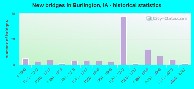
- New bridges - historical statistics
- 5Before 1900
- 21900-1909
- 41910-1919
- 11920-1929
- 31930-1939
- 31940-1949
- 31950-1959
- 21960-1969
- 381970-1979
- 11980-1989
- 121990-1999
- 72000-2009
- 42010-2019
- 12020-2022
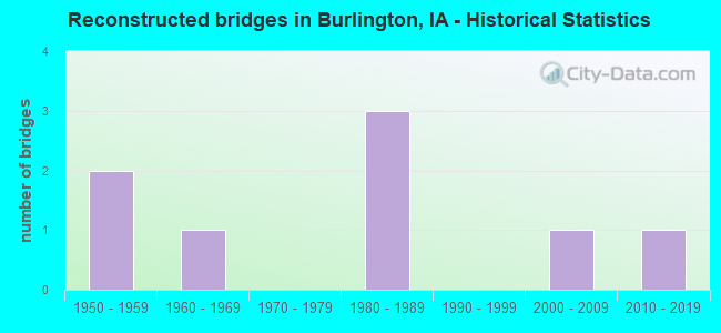
- Reconstructed bridges - Historical Statistics
- 21950-1959
- 11960-1969
- 01970-1979
- 31980-1989
- 01990-1999
- 12000-2009
- 12010-2019
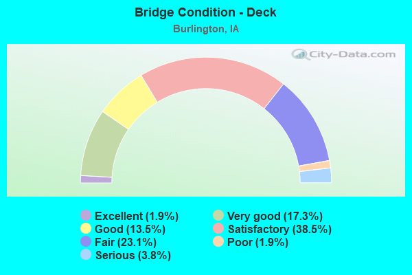
- Bridge Condition - Deck
- 1.9%Excellent
- 17.3%Very good
- 13.5%Good
- 38.5%Satisfactory
- 23.1%Fair
- 1.9%Poor
- 3.8%Serious
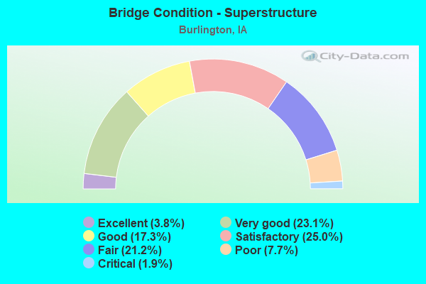
- Bridge Condition - Superstructure
- 3.8%Excellent
- 23.1%Very good
- 17.3%Good
- 25.0%Satisfactory
- 21.2%Fair
- 7.7%Poor
- 1.9%Critical
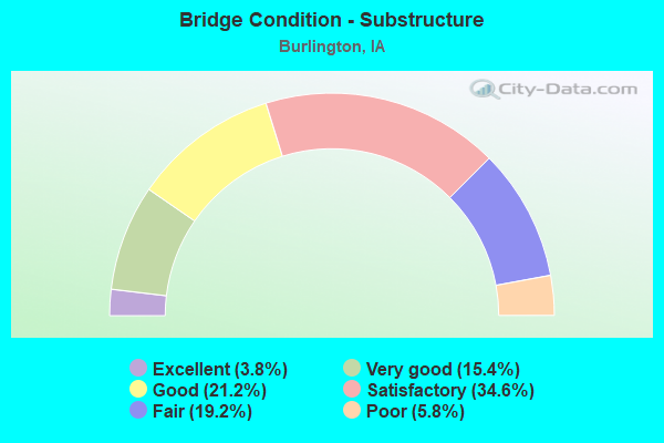
- Bridge Condition - Substructure
- 3.8%Excellent
- 15.4%Very good
- 21.2%Good
- 34.6%Satisfactory
- 19.2%Fair
- 5.8%Poor
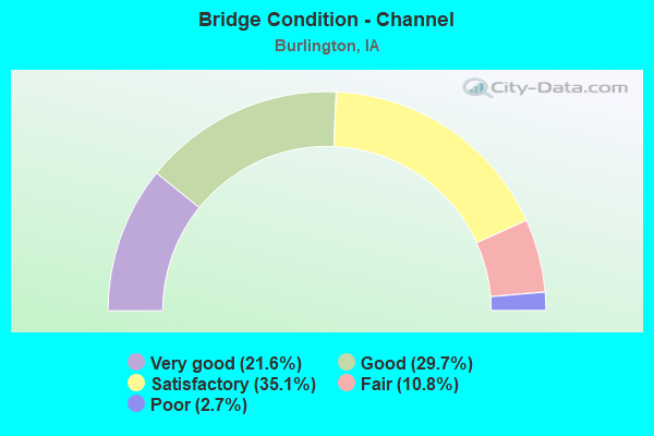
- Bridge Condition - Channel
- 21.6%Very good
- 29.7%Good
- 35.1%Satisfactory
- 10.8%Fair
- 2.7%Poor
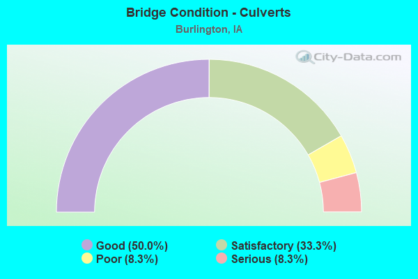
- Bridge Condition - Culverts
- 50.0%Good
- 33.3%Satisfactory
- 8.3%Poor
- 8.3%Serious
Find on map >> Show street view
Structure Number: 602935, Location: 1.4 MI. E OF JCT. US 61 (Lat: 40.815461, Lng: -91.111169), Route carried "on" structure: Ramp US 34, Year Built: 1972, Status: Open, Structure Length: 20.76m (68.11ft), Average Daily Traffic: 2,500 (year 2020), Truck Traffic: 1%, Average Future Daily Traffic: 2,500 (year 2040), Design Load: HS 20, Features Intersected: BNSF RR & CITY STREETS
Minimum Vertical Clearance: 30+ m (98+ ft), Kilometerpoint: 0.100, Lanes on structure: 1, Lanes under structure: 4, Owner: State Highway Agency, Approaching Roadway Width: 7.0m (23.0ft), Skew: 9 degrees, Material/Design: Steel continuous, Design/Construction: Girder and Floorbeam System, Number Of Spans In Main Unit: 3, Number Of Approach Spans: 6, Length of Maximum Span: 32.3m (106.0ft), Curb-To-Curb Width: 6.8m (22.3ft), Out-to-Out Width: 7.7m (25.3ft)
Condition: Deck: Satisfactory, Superstructure: Satisfactory, Substructure: Satisfactory, Operating Rating: 55.6 metric tons, Method Used To Determine Operating Rating: Load Factor (LF), Inventory Rating: 28.1 metric tons, Method Used To Determine Inventory Rating: Load Factor (LF), Structural Evaluation: Equal to present minimum criteria, Deck Geometry: Equal to present minimum criteria, Underclear: Meets minimum limits, Approach Roadway Alignment: Equal to present minimum criteria, Designated Inspection Frequency: Every 24 months, Critical Feature Inspection Frequency: Every 24 months, Other Special Inspection Frequency: Every 24 months, Inspection Date: October 2020, Critical Feature Inspection Date: October 2020, Other Special Inspection Date: October 2021, Deck Structure Type: Concrete Cast-file-Place, Wearing Surface/Protective System: Wearing Surface: Low Slump Concrete
Find on map >> Show street view
Structure Number: 60294, Location: 1.5 mi. E of Jct. US 61 (Lat: 40.816242, Lng: -91.111181), Route carried "on" structure: Ramp US 34, Year Built: 1972, Status: Open, Structure Length: 23.16m (75.98ft), Average Daily Traffic: 2,610 (year 2020), Truck Traffic: 1%, Average Future Daily Traffic: 2,610 (year 2040), Design Load: HS 20, Features Intersected: BNSF RR & CITY STREETS
Minimum Vertical Clearance: 30+ m (98+ ft), Kilometerpoint: 0.101, Lanes on structure: 1, Lanes under structure: 4, Owner: State Highway Agency, Approaching Roadway Width: 7.0m (23.0ft), Material/Design: Prestressed concrete, Design/Construction: Stringer/Multi-beam, Number Of Spans In Main Unit: 10, Length of Maximum Span: 26.5m (86.9ft), Curb-To-Curb Width: 6.7m (22.0ft), Out-to-Out Width: 7.7m (25.3ft)
Condition: Deck: Satisfactory, Superstructure: Satisfactory, Substructure: Satisfactory, Operating Rating: 90.2 metric tons, Method Used To Determine Operating Rating: Load Factor (LF), Inventory Rating: 25.3 metric tons, Method Used To Determine Inventory Rating: Load Factor (LF), Structural Evaluation: Equal to present minimum criteria, Deck Geometry: Equal to present minimum criteria, Underclear: Meets minimum limits, Approach Roadway Alignment: Better than present minimum criteria, Designated Inspection Frequency: Every 24 months, Inspection Date: October 2020, Deck Structure Type: Concrete Cast-file-Place, Wearing Surface/Protective System: Wearing Surface: Low Slump Concrete
Find on map >> Show street view
Structure Number: 602945, Location: 2.1 mi. E of Jct. U.S. 61 (Lat: 40.813819, Lng: -91.102603), Route carried "on" structure: City street , Year Built: 1970, Status: Open, Structure Length: 6.28m (20.60ft), Average Daily Traffic: 1,460 (year 2018), Average Future Daily Traffic: 1,460 (year 2041), Design Load: HS 20, Features Intersected: US 34, Facility Carried by Structure: 4TH ST
Minimum Vertical Clearance: 30+ m (98+ ft), Kilometerpoint: 2.448, Lanes on structure: 2, Lanes under structure: 5, Owner: State Highway Agency, Approaching Roadway Width: 12.2m (40.0ft), Material/Design: Prestressed concrete, Design/Construction: Stringer/Multi-beam, Number Of Spans In Main Unit: 4, Length of Maximum Span: 18.6m (61.0ft), Curb or Sidewalk Widths: Left: 1.5m (4.9ft), Right: 1.5m (4.9ft), Curb-To-Curb Width: 12.8m (42.0ft), Out-to-Out Width: 17.1m (56.1ft)
Condition: Deck: Satisfactory, Superstructure: Satisfactory, Substructure: Fair, Operating Rating: 68.8 metric tons, Method Used To Determine Operating Rating: Load Factor (LF), Inventory Rating: 33.8 metric tons, Method Used To Determine Inventory Rating: Load Factor (LF), Structural Evaluation: Somewhat better than minimum adequacy, Deck Geometry: Better than present minimum criteria, Underclear: Equal to present minimum criteria, Approach Roadway Alignment: Meets minimum limits, Designated Inspection Frequency: Every 24 months, Inspection Date: November 2021, Deck Structure Type: Concrete Cast-file-Place, Wearing Surface/Protective System: Wearing Surface: Low Slump Concrete
Find on map >> Show street view
Structure Number: 604846, Location: 0.3 MI W. OF ILLINOIS ST. (Lat: 40.813419, Lng: -91.100583), Route carried "on" structure: US 34, Year Built: 1971, Year Reconstructed: 1994, Status: Open, Structure Length: 16.12m (52.89ft), Average Daily Traffic: 11,100 (year 2020), Truck Traffic: 14%, Average Future Daily Traffic: 11,100 (year 2041), Design Load: HS 20, Features Intersected: BJRY AND CITY STS
Minimum Vertical Clearance: 30+ m (98+ ft), Kilometerpoint: 432.720, Lanes on structure: 4, Lanes under structure: 5, Base Highway Network: Yes, Owner: State Highway Agency, Approaching Roadway Width: 28.7m (94.2ft), Skew: 30 degrees, Material/Design: Steel continuous, Design/Construction: Stringer/Multi-beam, Number Of Spans In Main Unit: 8, Length of Maximum Span: 25.0m (82.0ft), Curb-To-Curb Width: 22.2m (72.8ft), Out-to-Out Width: 23.3m (76.4ft)
Condition: Deck: Fair, Superstructure: Satisfactory, Substructure: Satisfactory, Operating Rating: 58.1 metric tons, Method Used To Determine Operating Rating: Load Factor (LF), Inventory Rating: 34.9 metric tons, Method Used To Determine Inventory Rating: Load Factor (LF), Structural Evaluation: Equal to present minimum criteria, Deck Geometry: Superior to present desirable criteria, Underclear: Somewhat better than minimum adequacy, Approach Roadway Alignment: Equal to present minimum criteria, Designated Inspection Frequency: Every 24 months, Inspection Date: October 2021, Deck Structure Type: Concrete Cast-file-Place, Wearing Surface/Protective System: Wearing Surface: Low Slump Concrete
Find on map >> Show street view
Structure Number: 604851, Location: 0.2 mi. W of IL St. Line (Lat: 40.813000, Lng: -91.099008), Route carried "on" structure: Ramp US 34, Year Built: 1972, Year Reconstructed: 1993, Status: Open, Structure Length: 15.30m (50.20ft), Average Daily Traffic: 870 (year 2020), Truck Traffic: 10%, Average Future Daily Traffic: 870 (year 2040), Design Load: HS 20, Features Intersected: PARKING LOT
Minimum Vertical Clearance: 30+ m (98+ ft), Kilometerpoint: 0.179, Lanes on structure: 1, Lanes under structure: 2, Owner: State Highway Agency, Approaching Roadway Width: 7.0m (23.0ft), Material/Design: Steel continuous, Design/Construction: Girder and Floorbeam System, Number Of Spans In Main Unit: 6, Length of Maximum Span: 25.3m (83.0ft), Curb-To-Curb Width: 7.0m (23.0ft), Out-to-Out Width: 8.0m (26.2ft)
Condition: Deck: Satisfactory, Superstructure: Satisfactory, Substructure: Good, Operating Rating: 38.5 metric tons, Method Used To Determine Operating Rating: Load Factor (LF), Inventory Rating: 23.2 metric tons, Method Used To Determine Inventory Rating: Load Factor (LF), Structural Evaluation: Equal to present minimum criteria, Deck Geometry: Equal to present minimum criteria, Underclear: Meets minimum limits, Approach Roadway Alignment: Equal to present minimum criteria, Designated Inspection Frequency: Every 24 months, Critical Feature Inspection Frequency: Every 24 months, Other Special Inspection Frequency: Every 24 months, Inspection Date: October 2020, Critical Feature Inspection Date: October 2020, Other Special Inspection Date: October 2021, Deck Structure Type: Concrete Cast-file-Place, Wearing Surface/Protective System: Wearing Surface: Low Slump Concrete, Deck Protection: Epoxy Coated Reinforcing
Find on map >> Show street view
Structure Number: 604856, Location: 0.1 mi. W of IL Border (Lat: 40.812583, Lng: -91.099706), Route carried "on" structure: Ramp US 34, Year Built: 1993, Status: Open, Structure Length: 5.55m (18.21ft), Average Daily Traffic: 1,030 (year 2020), Truck Traffic: 9%, Average Future Daily Traffic: 1,030 (year 2040), Design Load: HS 20, Features Intersected: CITY STS, Facility Carried by Structure: S-E RAMP D
Minimum Vertical Clearance: 30+ m (98+ ft), Kilometerpoint: 0.159, Lanes on structure: 1, Lanes under structure: 4, Owner: State Highway Agency, Approaching Roadway Width: 4.9m (16.1ft), Skew: 9 degrees, Material/Design: Steel continuous, Design/Construction: Girder and Floorbeam System, Number Of Spans In Main Unit: 3, Length of Maximum Span: 18.6m (61.0ft), Curb-To-Curb Width: 6.9m (22.6ft), Out-to-Out Width: 8.0m (26.2ft)
Condition: Deck: Satisfactory, Superstructure: Very good, Substructure: Good, Operating Rating: 45.4 metric tons, Method Used To Determine Operating Rating: Load Factor (LF), Inventory Rating: 27.1 metric tons, Method Used To Determine Inventory Rating: Load Factor (LF), Structural Evaluation: Equal to present minimum criteria, Deck Geometry: Equal to present minimum criteria, Underclear: Somewhat better than minimum adequacy, Approach Roadway Alignment: Equal to present minimum criteria, Designated Inspection Frequency: Every 24 months, Critical Feature Inspection Frequency: Every 24 months, Other Special Inspection Frequency: Every 24 months, Inspection Date: October 2020, Critical Feature Inspection Date: October 2020, Other Special Inspection Date: October 2021, Deck Structure Type: Concrete Cast-file-Place, Wearing Surface/Protective System: Wearing Surface: Low Slump Concrete
Find on map >> Show street view
Structure Number: 60486, Location: 0.4 MI. W OF ILL ST. LINE (Lat: 40.813356, Lng: -91.100594), Route carried "on" structure: Ramp US 34, Year Built: 1972, Status: Open, Structure Length: 12.10m (39.70ft), Average Daily Traffic: 2,530 (year 2020), Truck Traffic: 10%, Average Future Daily Traffic: 2,530 (year 2040), Design Load: HS 20, Features Intersected: HIGH & MAIN ST, Facility Carried by Structure: E-S RAMP B
Minimum Vertical Clearance: 30+ m (98+ ft), Kilometerpoint: 0.103, Lanes on structure: 1, Lanes under structure: 6, Owner: State Highway Agency, Approaching Roadway Width: 15.9m (52.2ft), Material/Design: Steel continuous, Design/Construction: Girder and Floorbeam System, Number Of Spans In Main Unit: 6, Length of Maximum Span: 21.9m (71.9ft), Curb-To-Curb Width: 7.0m (23.0ft), Out-to-Out Width: 8.0m (26.2ft)
Condition: Deck: Satisfactory, Superstructure: Satisfactory, Substructure: Satisfactory, Operating Rating: 44.4 metric tons, Method Used To Determine Operating Rating: Load Factor (LF), Inventory Rating: 26.8 metric tons, Method Used To Determine Inventory Rating: Load Factor (LF), Structural Evaluation: Equal to present minimum criteria, Deck Geometry: Equal to present minimum criteria, Underclear: Meets minimum limits, Approach Roadway Alignment: Meets minimum limits, Designated Inspection Frequency: Every 24 months, Critical Feature Inspection Frequency: Every 24 months, Other Special Inspection Frequency: Every 24 months, Inspection Date: October 2020, Critical Feature Inspection Date: October 2020, Other Special Inspection Date: October 2021, Deck Structure Type: Concrete Cast-file-Place, Wearing Surface/Protective System: Wearing Surface: Low Slump Concrete
Find on map >> Show street view
Structure Number: 604865, Location: 0.4 mi. W of IL St. Line (Lat: 40.814189, Lng: -91.099633), Route carried "on" structure: Ramp US 34, Year Built: 1972, Status: Open, Structure Length: 12.44m (40.81ft), Average Daily Traffic: 2,250 (year 2020), Truck Traffic: 11%, Average Future Daily Traffic: 2,250 (year 2040), Design Load: HS 20, Features Intersected: PARKING LOT
Minimum Vertical Clearance: 30+ m (98+ ft), Kilometerpoint: 0.026, Lanes on structure: 1, Owner: State Highway Agency, Approaching Roadway Width: 7.0m (23.0ft), Material/Design: Steel continuous, Design/Construction: Girder and Floorbeam System, Number Of Spans In Main Unit: 6, Length of Maximum Span: 22.9m (75.1ft), Curb-To-Curb Width: 7.0m (23.0ft), Out-to-Out Width: 8.0m (26.2ft)
Condition: Deck: Satisfactory, Superstructure: Satisfactory, Substructure: Satisfactory, Operating Rating: 33.0 metric tons, Method Used To Determine Operating Rating: Load Factor (LF), Inventory Rating: 20.0 metric tons, Method Used To Determine Inventory Rating: Load Factor (LF), Structural Evaluation: Somewhat better than minimum adequacy, Deck Geometry: Equal to present minimum criteria, Approach Roadway Alignment: Meets minimum limits, Designated Inspection Frequency: Every 24 months, Critical Feature Inspection Frequency: Every 24 months, Other Special Inspection Frequency: Every 24 months, Inspection Date: October 2020, Critical Feature Inspection Date: October 2020, Other Special Inspection Date: October 2021, Deck Structure Type: Concrete Cast-file-Place, Wearing Surface/Protective System: Wearing Surface: Low Slump Concrete
Find on map >> Show street view
Structure Number: DAPAMCIOW005401, Location: APPROX. 500' S. OF RD. M (Lat: 40.781800, Lng: -91.250961), Route carried "on" structure: ServiceOther road , Year Built: 1933, Status: Posted for load, Structure Length: 3.76m (12.34ft), Average Daily Traffic: 15 (year 2014), Truck Traffic: 3%, Average Future Daily Traffic: 20 (year 2042), Features Intersected: LONG CREEK, Facility Carried by Structure: PLANT ROAD I
Minimum Vertical Clearance: 30+ m (98+ ft), Kilometerpoint: 0.000, Lanes on structure: 2, Owner: Army, Approaching Roadway Width: 7.0m (23.0ft), Material/Design: Steel continuous, Design/Construction: Stringer/Multi-beam, Number Of Spans In Main Unit: 3, Length of Maximum Span: 14.6m (47.9ft), Curb or Sidewalk Widths: Left: 0.6m (2.0ft), Right: 0.6m (2.0ft), Curb-To-Curb Width: 7.3m (24.0ft), Out-to-Out Width: 8.5m (27.9ft)
Condition: Deck: Fair, Superstructure: Fair, Substructure: Good, Channel: Good, Operating Rating: 28.8 metric tons, Method Used To Determine Operating Rating: Load Factor (LF), Inventory Rating: 17.3 metric tons, Method Used To Determine Inventory Rating: Load Factor (LF), Structural Evaluation: Somewhat better than minimum adequacy, Deck Geometry: Equal to present minimum criteria, Waterway Adequacy: Equal to present desirable criteria, Approach Roadway Alignment: Equal to present desirable criteria, Bridge Posting: Required (Relationship of Operating Rating to Maximum Legal Load: 10.0 - 19.9% below), Length Of Structure Improvement: 4.68m (15.35ft), Designated Inspection Frequency: Every 24 months, Inspection Date: March 2020, Bridge Improvement Cost: $80,000, Roadway Improvement Cost: $7,000, Total Project Cost: $87,000 ( Estimate for 2020), Deck Structure Type: Concrete Cast-file-Place
Find on map >> Show street view
Structure Number: DAPAMCIOW005402, Location: APPROX. 4000' S. OF RD. I (Lat: 40.772531, Lng: -91.246081), Route carried "on" structure: ServiceOther road , Year Built: 1910, Status: Closed, Structure Length: 1.83m (6.00ft), Average Daily Traffic: 10 (year 2014), Truck Traffic: 2%, Average Future Daily Traffic: 15 (year 2036), Features Intersected: LONG CREEK, Facility Carried by Structure: YARD G ROAD
Minimum Vertical Clearance: 30+ m (98+ ft), Kilometerpoint: 0.000, Lanes on structure: 1, Owner: Army, Approaching Roadway Width: 4.9m (16.1ft), Material/Design: Steel, Design/Construction: Truss - Thru, Number Of Spans In Main Unit: 1, Length of Maximum Span: 18.3m (60.0ft), Curb-To-Curb Width: 4.9m (16.1ft), Out-to-Out Width: 5.2m (17.1ft)
Condition: Deck: Fair, Superstructure: Poor, Substructure: Fair, Channel: Satisfactory, Operating Rating: 34.1 metric tons, Method Used To Determine Operating Rating: Allowable Stress (AS), Inventory Rating: 25.4 metric tons, Method Used To Determine Inventory Rating: Allowable Stress (AS), Structural Evaluation: Meets minimum limits, Deck Geometry: High priority of corrective action, Waterway Adequacy: Equal to present minimum criteria, Approach Roadway Alignment: Better than present minimum criteria, Bridge Posting: Required (Relationship of Operating Rating to Maximum Legal Load: > 39.9% below), Length Of Structure Improvement: 2.55m (8.37ft), Designated Inspection Frequency: Every 12 months, Critical Feature Inspection Frequency: Every 12 months, Inspection Date: August 2014, Critical Feature Inspection Date: August 2014, Bridge Improvement Cost: $4,000, Roadway Improvement Cost: $1,000, Total Project Cost: $5,000 ( Estimate for 2014), Deck Structure Type: Wood or Timber
Find on map >> Show street view
Structure Number: DAPAMCIOW005403, Location: APPROX. 8000' E. OF RD. H (Lat: 40.760400, Lng: -91.244889), Route carried "on" structure: ServiceOther road , Year Built: 1905, Status: Closed, Structure Length: 2.44m (8.01ft), Average Daily Traffic: 10 (year 2014), Truck Traffic: 3%, Average Future Daily Traffic: 15 (year 2036), Features Intersected: LONG CREEK, Facility Carried by Structure: PLANT ROAD K
Minimum Vertical Clearance: 30+ m (98+ ft), Kilometerpoint: 0.000, Lanes on structure: 1, Owner: Army, Approaching Roadway Width: 4.4m (14.4ft), Material/Design: Steel, Design/Construction: Truss - Thru, Number Of Spans In Main Unit: 1, Length of Maximum Span: 24.4m (80.1ft), Curb-To-Curb Width: 4.4m (14.4ft), Out-to-Out Width: 5.2m (17.1ft)
Condition: Deck: Fair, Superstructure: Fair, Substructure: Fair, Channel: Good, Operating Rating: 9.9 metric tons, Method Used To Determine Operating Rating: Allowable Stress (AS), Inventory Rating: 6.9 metric tons, Method Used To Determine Inventory Rating: Allowable Stress (AS), Deck Geometry: Equal to present minimum criteria, Waterway Adequacy: Better than present minimum criteria, Approach Roadway Alignment: Equal to present minimum criteria, Bridge Posting: Required (Relationship of Operating Rating to Maximum Legal Load: > 39.9% below), Length Of Structure Improvement: 3.31m (10.86ft), Designated Inspection Frequency: Every 12 months, Critical Feature Inspection Frequency: Every 12 months, Inspection Date: August 2014, Critical Feature Inspection Date: August 2014, Bridge Improvement Cost: $390,000, Roadway Improvement Cost: $10,000, Total Project Cost: $400,000 ( Estimate for 2014), Deck Structure Type: Wood or Timber
Find on map >> Show street view
Structure Number: DAPAMCIOW005404, Location: N OF STRUCTURE 05416 (Lat: 40.791589, Lng: -91.226231), Route carried "on" structure: ServiceOther road , Year Built: 1946, Status: Closed, Structure Length: 0.76m (2.49ft), Average Daily Traffic: 5 (year 2014), Average Future Daily Traffic: 10 (year 2036), Features Intersected: BRUSH CREEK, Facility Carried by Structure: UNNAMED ROAD
Minimum Vertical Clearance: 30+ m (98+ ft), Kilometerpoint: 0.000, Lanes on structure: 1, Owner: Army, Approaching Roadway Width: 3.7m (12.1ft), Material/Design: Concrete, Design/Construction: Culvert, Number Of Spans In Main Unit: 2, Length of Maximum Span: 3.7m (12.1ft)
Condition: Channel: Satisfactory, Culverts: Good, Waterway Adequacy: Equal to present minimum criteria, Approach Roadway Alignment: Somewhat better than minimum adequacy, Length Of Structure Improvement: 1.41m (4.63ft), Designated Inspection Frequency: Every 24 months, Inspection Date: August 2014, Bridge Improvement Cost: $16,000, Roadway Improvement Cost: $2,000, Total Project Cost: $18,000 ( Estimate for 2014)
Find on map >> Show street view
Structure Number: DAPAMCIOW005405, Location: APPROX. 7000' S. OF RD. D (Lat: 40.785089, Lng: -91.218900), Route carried "on" structure: ServiceOther road , Year Built: 2019, Status: Open, Structure Length: 1.92m (6.30ft), Average Daily Traffic: 20 (year 2020), Truck Traffic: 4%, Average Future Daily Traffic: 25 (year 2042), Design Load: HS 20, Features Intersected: BRUSH CREEK, Facility Carried by Structure: PLANT ROAD H
Minimum Vertical Clearance: 30+ m (98+ ft), Kilometerpoint: 0.000, Lanes on structure: 2, Owner: Army, Approaching Roadway Width: 8.2m (26.9ft), Material/Design: Concrete continuous, Design/Construction: Slab, Number Of Spans In Main Unit: 3, Length of Maximum Span: 7.3m (24.0ft), Curb-To-Curb Width: 9.3m (30.5ft), Out-to-Out Width: 10.1m (33.1ft)
Condition: Deck: Very good, Superstructure: Very good, Substructure: Very good, Channel: Very good, Operating Rating: 58.1 metric tons, Method Used To Determine Operating Rating: Load and Resistance Factor (LRFR), Inventory Rating: 44.7 metric tons, Method Used To Determine Inventory Rating: Load and Resistance Factor (LRFR), Structural Evaluation: Equal to present desirable criteria, Deck Geometry: Better than present minimum criteria, Waterway Adequacy: Equal to present desirable criteria, Approach Roadway Alignment: Equal to present desirable criteria, Length Of Structure Improvement: 2.65m (8.69ft), Designated Inspection Frequency: Every 24 months, Inspection Date: March 2020, Deck Structure Type: Concrete Cast-file-Place, Wearing Surface/Protective System: Deck Protection: Epoxy Coated Reinforcing
Find on map >> Show street view
Structure Number: DAPAMCIOW005406, Location: APPROX. 600' E. OF RD. H (Lat: 40.775869, Lng: -91.216581), Route carried "on" structure: ServiceOther road , Year Built: 1918, Status: Posted for load, Structure Length: 1.11m (3.64ft), Average Daily Traffic: 10 (year 2014), Truck Traffic: 2%, Average Future Daily Traffic: 15 (year 2042), Features Intersected: BRUSH CREEK, Facility Carried by Structure: MIDDLE ROAD
Minimum Vertical Clearance: 30+ m (98+ ft), Kilometerpoint: 0.000, Lanes on structure: 2, Owner: Army, Approaching Roadway Width: 6.4m (21.0ft), Skew: 1 degrees, Material/Design: Concrete, Design/Construction: Tee Beam, Number Of Spans In Main Unit: 1, Length of Maximum Span: 10.4m (34.1ft), Curb-To-Curb Width: 6.3m (20.7ft), Out-to-Out Width: 7.0m (23.0ft)
Condition: Deck: Fair, Superstructure: Satisfactory, Substructure: Fair, Channel: Satisfactory, Deck Geometry: Somewhat better than minimum adequacy, Waterway Adequacy: Better than present minimum criteria, Approach Roadway Alignment: Equal to present desirable criteria, Length Of Structure Improvement: 1.71m (5.61ft), Designated Inspection Frequency: Every 24 months, Inspection Date: March 2020, Bridge Improvement Cost: $31,000, Roadway Improvement Cost: $6,000, Total Project Cost: $37,000 ( Estimate for 2020), Deck Structure Type: Concrete Cast-file-Place, Wearing Surface/Protective System: Wearing Surface: Monolithic Concrete
Find on map >> Show street view
Structure Number: DAPAMCIOW005407, Location: APPROX. 6000' E. OF RD. H (Lat: 40.766839, Lng: -91.198511), Route carried "on" structure: ServiceOther road , Year Built: 2016, Status: Posted for load, Structure Length: 2.83m (9.28ft), Average Daily Traffic: 10 (year 2016), Truck Traffic: 3%, Average Future Daily Traffic: 15 (year 2042), Design Load: HL 93, Features Intersected: BRUSH CREEK, Facility Carried by Structure: PLANT ROAD K
Minimum Vertical Clearance: 30+ m (98+ ft), Kilometerpoint: 0.000, Lanes on structure: 2, Owner: Army, Approaching Roadway Width: 5.3m (17.4ft), Material/Design: Concrete continuous, Design/Construction: Slab, Number Of Spans In Main Unit: 3, Length of Maximum Span: 10.7m (35.1ft), Curb-To-Curb Width: 7.5m (24.6ft), Out-to-Out Width: 8.3m (27.2ft)
Condition: Deck: Good, Superstructure: Good, Substructure: Good, Channel: Good, Operating Rating: 71.3 metric tons, Method Used To Determine Operating Rating: Assigned rating based on Load Factor Design (LFD) reported by rating factor (RF) using MS18 loading, Inventory Rating: 42.1 metric tons, Method Used To Determine Inventory Rating: Assigned rating based on Load Factor Design (LFD) reported by rating factor (RF) using MS18 loading, Structural Evaluation: Better than present minimum criteria, Deck Geometry: Equal to present minimum criteria, Waterway Adequacy: Equal to present desirable criteria, Approach Roadway Alignment: Equal to present desirable criteria, Length Of Structure Improvement: 3.75m (12.30ft), Designated Inspection Frequency: Every 24 months, Inspection Date: March 2020, Bridge Improvement Cost: $390,000, Roadway Improvement Cost: $10,000, Total Project Cost: $400,000 ( Estimate for 2020), Deck Structure Type: Concrete Cast-file-Place
Find on map >> Show street view
Structure Number: DAPAMCIOW005408, Location: APPROX. 3000' N. OF RD. I (Lat: 40.792150, Lng: -91.276550), Route carried "on" structure: ServiceOther road , Year Built: 1948, Status: Posted for load, Structure Length: 1.86m (6.10ft), Average Daily Traffic: 10 (year 2014), Truck Traffic: 2%, Average Future Daily Traffic: 15 (year 2042), Features Intersected: LONG CREEK, Facility Carried by Structure: FS AREA ROAD
Minimum Vertical Clearance: 30+ m (98+ ft), Kilometerpoint: 0.000, Lanes on structure: 1, Owner: Army, Approaching Roadway Width: 4.9m (16.1ft), Material/Design: Steel continuous, Design/Construction: Stringer/Multi-beam, Number Of Spans In Main Unit: 3, Length of Maximum Span: 6.3m (20.7ft), Curb or Sidewalk Widths: Left: 0.4m (1.3ft), Right: 0.4m (1.3ft), Curb-To-Curb Width: 4.9m (16.1ft), Out-to-Out Width: 5.6m (18.4ft)
Condition: Deck: Satisfactory, Superstructure: Satisfactory, Substructure: Satisfactory, Channel: Fair, Operating Rating: 76.1 metric tons, Method Used To Determine Operating Rating: Load Factor (LF), Inventory Rating: 45.7 metric tons, Method Used To Determine Inventory Rating: Load Factor (LF), Structural Evaluation: Equal to present minimum criteria, Deck Geometry: High priority of corrective action, Waterway Adequacy: Better than present minimum criteria, Approach Roadway Alignment: Equal to present desirable criteria, Length Of Structure Improvement: 2.55m (8.37ft), Designated Inspection Frequency: Every 24 months, Inspection Date: March 2020, Bridge Improvement Cost: $25,000, Roadway Improvement Cost: $1,000, Total Project Cost: $26,000 ( Estimate for 2020), Deck Structure Type: Concrete Cast-file-Place, Wearing Surface/Protective System: Wearing Surface: Monolithic Concrete
Find on map >> Show street view
Structure Number: DAPAMCIOW00541, Location: APPROX. 8700' E. OF RD. H (Lat: 40.797169, Lng: -91.187081), Route carried "on" structure: ServiceOther road , Year Built: 1953, Status: Open, Structure Length: 1.22m (4.00ft), Average Daily Traffic: 5 (year 2014), Truck Traffic: 2%, Average Future Daily Traffic: 10 (year 2042), Features Intersected: SPRING CREEK, Facility Carried by Structure: PLANT ROAD P
Minimum Vertical Clearance: 30+ m (98+ ft), Kilometerpoint: 0.000, Lanes on structure: 1, Owner: Army, Approaching Roadway Width: 4.9m (16.1ft), Material/Design: Concrete, Design/Construction: Culvert, Number Of Spans In Main Unit: 1, Length of Maximum Span: 12.2m (40.0ft)
Condition: Channel: Good, Culverts: Satisfactory, Operating Rating: 54.5 metric tons, Method Used To Determine Operating Rating: Field evaluation and documented engineering judgment, Inventory Rating: 32.7 metric tons, Method Used To Determine Inventory Rating: Field evaluation and documented engineering judgment, Structural Evaluation: Equal to present minimum criteria, Waterway Adequacy: Better than present minimum criteria, Approach Roadway Alignment: Equal to present desirable criteria, Length Of Structure Improvement: 1.89m (6.20ft), Designated Inspection Frequency: Every 24 months, Inspection Date: March 2020, Bridge Improvement Cost: $19,000, Roadway Improvement Cost: $8,000, Total Project Cost: $27,000 ( Estimate for 2020)
Find on map >> Show street view
Structure Number: DAPAMCIOW005411, Location: APPROX. 7000' E. OF RD. H (Lat: 40.781689, Lng: -91.192739), Route carried "on" structure: ServiceOther road , Year Built: 1910, Status: Closed, Structure Length: 1.86m (6.10ft), Average Daily Traffic: 5 (year 2014), Truck Traffic: 2%, Average Future Daily Traffic: 10 (year 2036), Features Intersected: SPRING CREEK, Facility Carried by Structure: MIDDLE ROAD
Minimum Vertical Clearance: 30+ m (98+ ft), Kilometerpoint: 0.000, Lanes on structure: 1, Owner: Army, Approaching Roadway Width: 4.7m (15.4ft), Material/Design: Steel, Design/Construction: Truss - Thru, Number Of Spans In Main Unit: 1, Length of Maximum Span: 18.6m (61.0ft), Curb-To-Curb Width: 4.7m (15.4ft), Out-to-Out Width: 5.2m (17.1ft)
Condition: Deck: Fair, Superstructure: Poor, Substructure: Fair, Channel: Satisfactory, Operating Rating: 16.6 metric tons, Method Used To Determine Operating Rating: Allowable Stress (AS), Inventory Rating: 9.8 metric tons, Method Used To Determine Inventory Rating: Allowable Stress (AS), Deck Geometry: Better than present minimum criteria, Waterway Adequacy: Better than present minimum criteria, Approach Roadway Alignment: High priority of corrective action, Bridge Posting: Required (Relationship of Operating Rating to Maximum Legal Load: > 39.9% below), Length Of Structure Improvement: 2.58m (8.46ft), Designated Inspection Frequency: Every 24 months, Critical Feature Inspection Frequency: Every 12 months, Inspection Date: August 2014, Critical Feature Inspection Date: August 2014, Bridge Improvement Cost: $390,000, Roadway Improvement Cost: $10,000, Total Project Cost: $400,000 ( Estimate for 2014), Deck Structure Type: Concrete Cast-file-Place, Wearing Surface/Protective System: Wearing Surface: Bituminous
Find on map >> Show street view
Structure Number: DAPAMCIOW005412, Location: APPROX. 10,000' E. RD. H (Lat: 40.770889, Lng: -91.185511), Route carried "on" structure: ServiceOther road , Year Built: 1910, Status: Closed, Structure Length: 1.98m (6.50ft), Average Daily Traffic: 5 (year 2014), Truck Traffic: 2%, Average Future Daily Traffic: 10 (year 2036), Features Intersected: SPRING CREEK, Facility Carried by Structure: PLANT ROAD K
Minimum Vertical Clearance: 30+ m (98+ ft), Kilometerpoint: 0.000, Lanes on structure: 1, Owner: Army, Approaching Roadway Width: 4.4m (14.4ft), Material/Design: Steel, Design/Construction: Truss - Thru, Number Of Spans In Main Unit: 1, Length of Maximum Span: 19.8m (65.0ft), Curb-To-Curb Width: 4.4m (14.4ft), Out-to-Out Width: 4.8m (15.7ft)
Condition: Deck: Satisfactory, Superstructure: Fair, Substructure: Fair, Channel: Fair, Operating Rating: 15.9 metric tons, Method Used To Determine Operating Rating: Allowable Stress (AS), Inventory Rating: 9.2 metric tons, Method Used To Determine Inventory Rating: Allowable Stress (AS), Deck Geometry: Equal to present minimum criteria, Waterway Adequacy: Better than present minimum criteria, Approach Roadway Alignment: Somewhat better than minimum adequacy, Bridge Posting: Required (Relationship of Operating Rating to Maximum Legal Load: > 39.9% below), Length Of Structure Improvement: 2.73m (8.96ft), Designated Inspection Frequency: Every 24 months, Critical Feature Inspection Frequency: Every 12 months, Inspection Date: August 2014, Critical Feature Inspection Date: August 2014, Bridge Improvement Cost: $4,000, Roadway Improvement Cost: $1,000, Total Project Cost: $5,000 ( Estimate for 2014), Deck Structure Type: Concrete Cast-file-Place, Wearing Surface/Protective System: Wearing Surface: Bituminous
Find on map >> Show street view
Structure Number: DAPAMCIOW005414, Location: APPROX. 1900' N. OF RD. I (Lat: 40.787581, Lng: -91.271061), Route carried "on" structure: ServiceOther road , Year Built: 2000, Status: Open, Structure Length: 1.14m (3.74ft), Average Daily Traffic: 20 (year 2014), Truck Traffic: 3%, Average Future Daily Traffic: 25 (year 2042), Features Intersected: LONG CREEK, Facility Carried by Structure: PLANT ROAD C
Minimum Vertical Clearance: 30+ m (98+ ft), Kilometerpoint: 0.000, Lanes on structure: 2, Owner: Army, Approaching Roadway Width: 6.9m (22.6ft), Material/Design: Concrete, Design/Construction: Culvert, Number Of Spans In Main Unit: 3, Length of Maximum Span: 3.7m (12.1ft)
Condition: Channel: Satisfactory, Culverts: Good, Operating Rating: 54.5 metric tons, Method Used To Determine Operating Rating: Field evaluation and documented engineering judgment, Inventory Rating: 32.7 metric tons, Method Used To Determine Inventory Rating: Field evaluation and documented engineering judgment, Structural Evaluation: Better than present minimum criteria, Waterway Adequacy: Better than present minimum criteria, Approach Roadway Alignment: Equal to present desirable criteria, Length Of Structure Improvement: 1.83m (6.00ft), Designated Inspection Frequency: Every 24 months, Inspection Date: March 2020, Bridge Improvement Cost: $11,000, Roadway Improvement Cost: $2,000, Total Project Cost: $13,000 ( Estimate for 2020)
Find on map >> Show street view
Structure Number: DAPAMCIOW005415, Location: APPROX. 5200 S. OF RD. I (Lat: 40.767331, Lng: -91.246531), Route carried "on" structure: ServiceOther road , Year Built: 1974, Status: Open, Structure Length: 1.71m (5.61ft), Average Daily Traffic: 10 (year 2014), Truck Traffic: 3%, Average Future Daily Traffic: 10 (year 2042), Features Intersected: LONG CREEK, Facility Carried by Structure: YARD G ROAD
Minimum Vertical Clearance: 30+ m (98+ ft), Kilometerpoint: 0.000, Lanes on structure: 1, Owner: Army, Approaching Roadway Width: 5.0m (16.4ft), Material/Design: Steel, Design/Construction: Culvert, Number Of Spans In Main Unit: 3, Length of Maximum Span: 5.2m (17.1ft)
Condition: Channel: Poor, Culverts: Good, Waterway Adequacy: Equal to present minimum criteria, Approach Roadway Alignment: Equal to present desirable criteria, Length Of Structure Improvement: 2.41m (7.91ft), Designated Inspection Frequency: Every 24 months, Inspection Date: March 2020, Bridge Improvement Cost: $28,000, Roadway Improvement Cost: $3,000, Total Project Cost: $31,000 ( Estimate for 2020)
Find on map >> Show street view
Structure Number: DAPAMCIOW005486, Location: APPROX. 1000' SW OF RD M (Lat: 40.782339, Lng: -91.250519), Route carried "on" structure: ServiceOther road , Year Built: 2009, Status: Open, Structure Length: 1.78m (5.84ft), Average Daily Traffic: 15 (year 2014), Truck Traffic: 3%, Average Future Daily Traffic: 20 (year 2042), Design Load: HS 20, Features Intersected: LONG CREEK, Facility Carried by Structure: PLANT ROAD I
Minimum Vertical Clearance: 30+ m (98+ ft), Kilometerpoint: 0.000, Lanes on structure: 2, Owner: Army, Approaching Roadway Width: 7.3m (24.0ft), Skew: 3 degrees, Material/Design: Concrete, Design/Construction: Culvert, Number Of Spans In Main Unit: 4, Length of Maximum Span: 4.2m (13.8ft)
Condition: Channel: Good, Culverts: Good, Operating Rating: 54.5 metric tons, Method Used To Determine Operating Rating: Field evaluation and documented engineering judgment, Inventory Rating: 32.7 metric tons, Method Used To Determine Inventory Rating: Field evaluation and documented engineering judgment, Structural Evaluation: Better than present minimum criteria, Waterway Adequacy: Better than present minimum criteria, Approach Roadway Alignment: Equal to present desirable criteria, Length Of Structure Improvement: 2.49m (8.17ft), Designated Inspection Frequency: Every 24 months, Inspection Date: March 2020, Bridge Improvement Cost: $6,000, Roadway Improvement Cost: $1,000, Total Project Cost: $7,000 ( Estimate for 2020)
Find on map >> Show street view
Structure Number: DAPAMCIOW00549, Location: APPROX 5000' E. OF RD. H (Lat: 40.804211, Lng: -91.200381), Route carried "on" structure: ServiceOther road , Year Built: 1940, Status: Closed, Structure Length: 1.59m (5.22ft), Average Daily Traffic: 5 (year 2014), Truck Traffic: 2%, Average Future Daily Traffic: 10 (year 2036), Features Intersected: SPRING CREEK, Facility Carried by Structure: EXP. DISP. AREA RD
Minimum Vertical Clearance: 30+ m (98+ ft), Kilometerpoint: 0.000, Lanes on structure: 1, Owner: Army, Approaching Roadway Width: 4.9m (16.1ft), Material/Design: Steel, Design/Construction: Culvert, Number Of Spans In Main Unit: 5, Length of Maximum Span: 2.4m (7.9ft)
Condition: Channel: Fair, Culverts: Serious, Waterway Adequacy: Better than present minimum criteria, Approach Roadway Alignment: Better than present minimum criteria, Length Of Structure Improvement: 2.27m (7.45ft), Designated Inspection Frequency: Every 24 months, Inspection Date: August 2014, Bridge Improvement Cost: $4,000, Roadway Improvement Cost: $1,000, Total Project Cost: $5,000 ( Estimate for 2014)
Find on map >> Show street view
Structure Number: DAPAMCIOW005491, Location: APPROX. 3000' N. OF RD I (Lat: 40.793700, Lng: -91.279461), Route carried "on" structure: ServiceOther road , Year Built: 1998, Status: Open, Structure Length: 0.98m (3.22ft), Average Daily Traffic: 10 (year 2014), Truck Traffic: 2%, Average Future Daily Traffic: 15 (year 2042), Features Intersected: LONG CREEK, Facility Carried by Structure: PLANT ROAD FS-12
Minimum Vertical Clearance: 30+ m (98+ ft), Kilometerpoint: 0.000, Lanes on structure: 1, Owner: Army, Approaching Roadway Width: 4.3m (14.1ft), Material/Design: Steel, Design/Construction: Culvert, Number Of Spans In Main Unit: 2, Length of Maximum Span: 4.5m (14.8ft)
Condition: Channel: Fair, Culverts: Satisfactory, Waterway Adequacy: Equal to present minimum criteria, Approach Roadway Alignment: Equal to present minimum criteria, Length Of Structure Improvement: 1.42m (4.66ft), Designated Inspection Frequency: Every 24 months, Inspection Date: March 2020, Bridge Improvement Cost: $19,000, Roadway Improvement Cost: $1,000, Total Project Cost: $20,000 ( Estimate for 2020)
Find on map >> Show street view
Structure Number: 871, Location: 700234000 (Lat: 40.824503, Lng: -91.106942), Route carried "under" structure: City street , Year Built: 1882, Structure Length: 0. m, Average Daily Traffic: 805 (year 1998), Features Intersected: DES MOINES ST, Facility Carried by Structure: ASH ST
Minimum Vertical Clearance: 30+ m (98+ ft), Kilometerpoint: 2.432, Lanes on structure: 2, Lanes under structure: 2, Material/Design: Masonry, Design/Construction: Arch - Deck, Length of Maximum Span: 7.3m (24.0ft)
Find on map >> Show street view
Structure Number: 881, Location: 690205000 (Lat: 40.809008, Lng: -91.106642), Route carried "under" structure: City street , Year Built: 1993, Structure Length: 0. m, Average Daily Traffic: 2,110 (year 2010), Features Intersected: BNSF RR & VALLEY ST, Facility Carried by Structure: 6TH ST
Minimum Vertical Clearance: 30+ m (98+ ft), Kilometerpoint: 1.708, Lanes on structure: 2, Lanes under structure: 2, Material/Design: Prestressed concrete, Design/Construction: Stringer/Multi-beam, Length of Maximum Span: 29.3m (96.1ft)
Find on map >> Show street view
Structure Number: 9, Location: 000000000 (Lat: 40.781114, Lng: -91.098608), Route carried "under" structure: City street , Year Built: 1896, Structure Length: 0. m, Average Daily Traffic: 289 (year 2019), Features Intersected: CASCADE LANDING, Facility Carried by Structure: SO MAIN ST
Minimum Vertical Clearance: 30+ m (98+ ft), Kilometerpoint: 0.319, Lanes on structure: 2, Material/Design: Steel, Design/Construction: Truss - Deck, Length of Maximum Span: 48.8m (160.1ft)
Find on map >> Show street view
Structure Number: 23431, Location: 000234000 (Lat: 40.818119, Lng: -91.114033), Route carried "under" structure: City street , Year Built: 2019, Structure Length: 0. m, Average Daily Traffic: 4,060 (year 2018), Features Intersected: BNSF RR & OSBORN, Facility Carried by Structure: MT PLEASANT ST
Minimum Vertical Clearance: 30+ m (98+ ft), Kilometerpoint: 0.499, Lanes on structure: 2, Lanes under structure: 2, Material/Design: Prestressed concrete, Design/Construction: Stringer/Multi-beam, Length of Maximum Span: 41.8m (137.1ft)
Find on map >> Show street view
Structure Number: 2362, Location: 1.7 mi E of Jct US 61 (Lat: 40.815536, Lng: -91.110200), Route carried "under" structure: US 34, Year Built: 1970, Structure Length: 0. m, Average Daily Traffic: 15,000 (year 2020), Truck Traffic: 13%, Features Intersected: US 34, Facility Carried by Structure: CENTRAL AVE
Minimum Vertical Clearance: 30+ m (98+ ft), Kilometerpoint: 431.856, Lanes on structure: 2, Lanes under structure: 4, Material/Design: Prestressed concrete, Design/Construction: Stringer/Multi-beam, Length of Maximum Span: 21.9m (71.9ft)
Find on map >> Show street view
Structure Number: 2363, Location: 1.8 mi. E of Jct. US 61 (Lat: 40.814944, Lng: -91.107144), Route carried "under" structure: US 34, Year Built: 1971, Structure Length: 0. m, Average Daily Traffic: 15,000 (year 2020), Truck Traffic: 13%, Features Intersected: US 34, Facility Carried by Structure: 8TH ST
Minimum Vertical Clearance: 30+ m (98+ ft), Kilometerpoint: 432.127, Lanes on structure: 2, Lanes under structure: 6, Material/Design: Prestressed concrete, Design/Construction: Stringer/Multi-beam, Length of Maximum Span: 29.3m (96.1ft)
Find on map >> Show street view
Structure Number: 2365, Location: 2.0 mi. E of Jct. US 61 (Lat: 40.814817, Lng: -91.103497), Route carried "under" structure: US 34, Year Built: 1970, Structure Length: 0. m, Average Daily Traffic: 15,800 (year 2020), Truck Traffic: 13%, Features Intersected: US 34, Facility Carried by Structure: 5TH ST
Minimum Vertical Clearance: 30+ m (98+ ft), Kilometerpoint: 432.424, Lanes on structure: 2, Lanes under structure: 5, Material/Design: Prestressed concrete, Design/Construction: Stringer/Multi-beam, Length of Maximum Span: 18.6m (61.0ft)
Find on map >> Show street view
Structure Number: 60287, Location: AT JCT. U.S. 34 (Lat: 40.817242, Lng: -91.141347), Route carried "under" structure: US 34, Year Built: 1973, Structure Length: 0. m, Average Daily Traffic: 8,800 (year 2020), Truck Traffic: 14%, Features Intersected: US 34, Facility Carried by Structure: US 61
Minimum Vertical Clearance: 30+ m (98+ ft), Kilometerpoint: 429.198, Lanes on structure: 4, Lanes under structure: 5, Material/Design: Prestressed concrete, Design/Construction: Stringer/Multi-beam, Length of Maximum Span: 25.0m (82.0ft)
Find on map >> Show street view
Structure Number: 60288, Location: 0.8 mi. E of Jct. US 61 (Lat: 40.817172, Lng: -91.126328), Route carried "under" structure: US 34, Year Built: 1973, Structure Length: 0. m, Average Daily Traffic: 14,700 (year 2020), Truck Traffic: 14%, Features Intersected: US 34, Facility Carried by Structure: CURRAN ST
Minimum Vertical Clearance: 30+ m (98+ ft), Kilometerpoint: 430.472, Lanes on structure: 2, Lanes under structure: 4, Material/Design: Prestressed concrete, Design/Construction: Stringer/Multi-beam, Length of Maximum Span: 25.0m (82.0ft)
Find on map >> Show street view
Structure Number: 602885, Location: 1.5 mi. E of Jct. U.S. 61 (Lat: 40.815978, Lng: -91.113719), Route carried "under" structure: City street , Year Built: 1972, Structure Length: 0. m, Average Daily Traffic: 735 (year 1990), Features Intersected: BNSF RR, CITY STS, Facility Carried by Structure: US 34 EB
Minimum Vertical Clearance: 30+ m (98+ ft), Kilometerpoint: 0.077, Lanes on structure: 2, Lanes under structure: 4, Material/Design: Steel continuous, Design/Construction: Stringer/Multi-beam, Length of Maximum Span: 33.5m (109.9ft)
Find on map >> Show street view
Structure Number: 602885, Location: 1.5 mi. E of Jct. U.S. 61 (Lat: 40.815978, Lng: -91.113719), Route carried "under" structure: City street , Year Built: 1972, Structure Length: 0. m, Average Daily Traffic: 2,265 (year 2018), Features Intersected: BNSF RR, CITY STS, Facility Carried by Structure: US 34 EB
Minimum Vertical Clearance: 30+ m (98+ ft), Kilometerpoint: 0.264, Lanes on structure: 2, Lanes under structure: 4, Material/Design: Steel continuous, Design/Construction: Stringer/Multi-beam, Length of Maximum Span: 33.5m (109.9ft)
Find on map >> Show street view
Structure Number: 602887, Location: 1.5 mi. E of Jct. US 61 (Lat: 40.815922, Lng: -91.111222), Route carried "under" structure: City street , Year Built: 1972, Structure Length: 0. m, Average Daily Traffic: 735 (year 1990), Features Intersected: BNSF RR, CITY STS, Facility Carried by Structure: US 34 WB
Minimum Vertical Clearance: 30+ m (98+ ft), Kilometerpoint: 0.090, Lanes on structure: 2, Lanes under structure: 4, Material/Design: Steel continuous, Design/Construction: Stringer/Multi-beam, Length of Maximum Span: 33.5m (109.9ft)
Find on map >> Show street view
Structure Number: 602935, Location: 1.4 MI. E OF JCT. US 61 (Lat: 40.815461, Lng: -91.111169), Route carried "under" structure: City street , Year Built: 1972, Structure Length: 0. m, Average Daily Traffic: 1,470 (year 1990), Features Intersected: BNSF RR & CITY STREETS, Facility Carried by Structure: US 34 RAMP
Minimum Vertical Clearance: 30+ m (98+ ft), Kilometerpoint: 0.051, Lanes on structure: 1, Lanes under structure: 4, Material/Design: Steel continuous, Design/Construction: Girder and Floorbeam System, Length of Maximum Span: 32.3m (106.0ft)
Find on map >> Show street view
Structure Number: 602935, Location: 1.4 MI. E OF JCT. US 61 (Lat: 40.815461, Lng: -91.111169), Route carried "under" structure: City street , Year Built: 1972, Structure Length: 0. m, Average Daily Traffic: 4,530 (year 2018), Features Intersected: BNSF RR & CITY STREETS, Facility Carried by Structure: US 34 RAMP
Minimum Vertical Clearance: 30+ m (98+ ft), Kilometerpoint: 0.241, Lanes on structure: 1, Lanes under structure: 4, Material/Design: Steel continuous, Design/Construction: Girder and Floorbeam System, Length of Maximum Span: 32.3m (106.0ft)
Find on map >> Show street view
Structure Number: 60294, Location: 1.5 mi. E of Jct. US 61 (Lat: 40.816242, Lng: -91.111181), Route carried "under" structure: City street , Year Built: 1972, Structure Length: 0. m, Average Daily Traffic: 1,470 (year 1990), Features Intersected: BNSF RR & CITY STREETS, Facility Carried by Structure: US 34 RAMP C
Minimum Vertical Clearance: 30+ m (98+ ft), Kilometerpoint: 0.127, Lanes on structure: 1, Lanes under structure: 4, Material/Design: Prestressed concrete, Design/Construction: Stringer/Multi-beam, Length of Maximum Span: 26.5m (86.9ft)
Find on map >> Show street view
Structure Number: 60294, Location: 1.5 mi. E of Jct. US 61 (Lat: 40.816242, Lng: -91.111181), Route carried "under" structure: City street , Year Built: 1972, Structure Length: 0. m, Average Daily Traffic: 4,530 (year 2018), Features Intersected: BNSF RR & CITY STREETS, Facility Carried by Structure: US 34 RAMP C
Minimum Vertical Clearance: 30+ m (98+ ft), Kilometerpoint: 0.311, Lanes on structure: 1, Lanes under structure: 4, Material/Design: Prestressed concrete, Design/Construction: Stringer/Multi-beam, Length of Maximum Span: 26.5m (86.9ft)
Find on map >> Show street view
Structure Number: 602945, Location: 2.1 mi. E of Jct. U.S. 61 (Lat: 40.813819, Lng: -91.102603), Route carried "under" structure: US 34, Year Built: 1970, Structure Length: 0. m, Average Daily Traffic: 15,800 (year 2020), Truck Traffic: 13%, Features Intersected: US 34, Facility Carried by Structure: 4TH ST
Minimum Vertical Clearance: 30+ m (98+ ft), Kilometerpoint: 432.527, Lanes on structure: 2, Lanes under structure: 5, Material/Design: Prestressed concrete, Design/Construction: Stringer/Multi-beam, Length of Maximum Span: 18.6m (61.0ft)
Find on map >> Show street view
Structure Number: 604846, Location: 0.3 MI W. OF ILLINOIS ST. (Lat: 40.813419, Lng: -91.100583), Route carried "under" structure: City street , Year Built: 1971, Structure Length: 0. m, Average Daily Traffic: 5,200 (year 2018), Features Intersected: BJRY AND CITY STS, Facility Carried by Structure: US 34
Minimum Vertical Clearance: 30+ m (98+ ft), Kilometerpoint: 5.137, Lanes on structure: 4, Lanes under structure: 5, Material/Design: Steel continuous, Design/Construction: Stringer/Multi-beam, Length of Maximum Span: 25.0m (82.0ft)
Find on map >> Show street view
Structure Number: 604851, Location: 0.2 mi. W of IL St. Line (Lat: 40.813000, Lng: -91.099008), Route carried "under" structure: City street , Year Built: 1972, Structure Length: 0. m, Average Daily Traffic: 500 (year 2021), Features Intersected: PARKING LOT, Facility Carried by Structure: US 34 WB OFF RAMP
Minimum Vertical Clearance: 30+ m (98+ ft), Kilometerpoint: 0.628, Lanes on structure: 1, Lanes under structure: 2, Material/Design: Steel continuous, Design/Construction: Girder and Floorbeam System, Length of Maximum Span: 25.3m (83.0ft)
Find on map >> Show street view
Structure Number: 604856, Location: 0.1 mi. W of IL Border (Lat: 40.812583, Lng: -91.099706), Route carried "under" structure: City street , Year Built: 1993, Structure Length: 0. m, Average Daily Traffic: 1,407 (year 1998), Features Intersected: CITY STS, Facility Carried by Structure: S-E RAMP D
Minimum Vertical Clearance: 30+ m (98+ ft), Kilometerpoint: 0.739, Lanes on structure: 1, Lanes under structure: 4, Material/Design: Steel continuous, Design/Construction: Girder and Floorbeam System, Length of Maximum Span: 18.6m (61.0ft)
Find on map >> Show street view
Structure Number: 60486, Location: 0.4 MI. W OF ILL ST. LINE (Lat: 40.813356, Lng: -91.100594), Route carried "under" structure: City street , Year Built: 1972, Structure Length: 0. m, Average Daily Traffic: 1,407 (year 1998), Features Intersected: HIGH & MAIN ST, Facility Carried by Structure: E-S RAMP B
Minimum Vertical Clearance: 30+ m (98+ ft), Kilometerpoint: 0.707, Lanes on structure: 1, Lanes under structure: 6, Material/Design: Steel continuous, Design/Construction: Girder and Floorbeam System, Length of Maximum Span: 21.9m (71.9ft)
Find on map >> Show street view
Structure Number: 60486, Location: 0.4 MI. W OF ILL ST. LINE (Lat: 40.813356, Lng: -91.100594), Route carried "under" structure: City street , Year Built: 1972, Structure Length: 0. m, Average Daily Traffic: 5,200 (year 2018), Features Intersected: HIGH & MAIN ST, Facility Carried by Structure: E-S RAMP B
Minimum Vertical Clearance: 30+ m (98+ ft), Kilometerpoint: 5.126, Lanes on structure: 1, Lanes under structure: 6, Material/Design: Steel continuous, Design/Construction: Girder and Floorbeam System, Length of Maximum Span: 21.9m (71.9ft)