Bridge Statistics for California, Pennsylvania (PA)
Condition, Traffic, Stress, Structural Evaluation, Project Costs
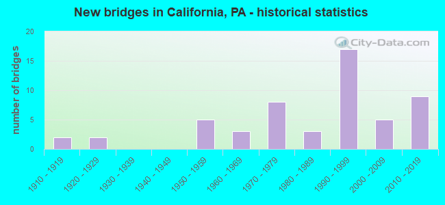
- New bridges - historical statistics
- 21910-1919
- 21920-1929
- 51950-1959
- 31960-1969
- 81970-1979
- 31980-1989
- 171990-1999
- 52000-2009
- 92010-2019


- Bridge Condition - Deck
- 11.5%Excellent
- 11.5%Very good
- 30.8%Good
- 30.8%Satisfactory
- 11.5%Fair
- 3.8%Poor

- Bridge Condition - Superstructure
- 3.4%Excellent
- 24.1%Very good
- 27.6%Good
- 24.1%Satisfactory
- 17.2%Fair
- 3.4%Poor

- Bridge Condition - Substructure
- 6.9%Excellent
- 13.8%Very good
- 10.3%Good
- 37.9%Satisfactory
- 24.1%Fair
- 6.9%Poor

- Bridge Condition - Channel
- 10.5%Excellent
- 10.5%Very good
- 21.1%Good
- 15.8%Satisfactory
- 31.6%Fair
- 10.5%Poor

- Bridge Condition - Culverts
- 33.3%Very good
- 33.3%Good
- 33.3%Satisfactory
Find on map >> Show street view
Structure Number: 40136, Location: NORTH OF 43&70 INTER. (Lat: 40.101667, Lng: -79.918056), Route carried "under" structure: State highway 43, Year Built: 1996, Structure Length: 0. m, Average Daily Traffic: 11,166 (year 2008), Truck Traffic: 4%, Features Intersected: PA TPK (TOLL 43), Facility Carried by Structure: T-465 KENNEDY RD
Minimum Vertical Clearance: 5.93m (19.46ft), Kilometerpoint: 0.000, Lanes on structure: 2, Lanes under structure: 6, Material/Design: Steel continuous, Design/Construction: Stringer/Multi-beam, Length of Maximum Span: 65.5m (214.9ft)
Find on map >> Show street view
Structure Number: 40136, Location: NORTH OF 43&70 INTER. (Lat: 40.101667, Lng: -79.918056), Route carried "under" structure: Ramp State highway 7043, Year Built: 1996, Structure Length: 0. m, Average Daily Traffic: 500 (year 2008), Truck Traffic: 4%, Features Intersected: PA TPK (TOLL 43), Facility Carried by Structure: T-465 KENNEDY RD
Minimum Vertical Clearance: 7.05m (23.13ft), Kilometerpoint: 0.000, Lanes on structure: 2, Lanes under structure: 1, Material/Design: Steel continuous, Design/Construction: Stringer/Multi-beam, Length of Maximum Span: 65.5m (214.9ft)
Find on map >> Show street view
Structure Number: 41983, Location: 1MI. N OF I70 INTERCHANGE (Lat: 40.119444, Lng: -79.927778), Route carried "under" structure: State highway , Year Built: 2000, Structure Length: 0. m, Average Daily Traffic: 2,280 (year 2021), Truck Traffic: 4%, Features Intersected: SR2016,RR,MAPLE C, Facility Carried by Structure: PA TPK (TOLL43)
Minimum Vertical Clearance: 30.18m (99.02ft), Kilometerpoint: 2.433, Lanes on structure: 2, Lanes under structure: 2, Material/Design: Steel continuous, Design/Construction: Stringer/Multi-beam, Length of Maximum Span: 82.9m (272.0ft)
Find on map >> Show street view
Structure Number: 41984, Location: 1MI. N OF I70 INTERCHANGE (Lat: 40.119444, Lng: -79.927778), Route carried "under" structure: State highway , Year Built: 2000, Structure Length: 0. m, Average Daily Traffic: 2,280 (year 2021), Truck Traffic: 4%, Features Intersected: SR2016,RR,MAPLE C, Facility Carried by Structure: PA TPK TOLL43,SB
Minimum Vertical Clearance: 30.18m (99.02ft), Kilometerpoint: 2.433, Lanes on structure: 2, Lanes under structure: 2, Material/Design: Steel continuous, Design/Construction: Stringer/Multi-beam, Length of Maximum Span: 81.7m (268.0ft)
Find on map >> Show street view
Structure Number: 54172, Location: 0.2 mi E from SR 0481 (Lat: 40.125153, Lng: -79.958128), Route carried "under" structure: State highway 481, Year Built: 2017, Structure Length: 0. m, Average Daily Traffic: 4,828 (year 2021), Truck Traffic: 11%, Features Intersected: SR 0481, Facility Carried by Structure: SR 0070 EB
Minimum Vertical Clearance: 5.03m (16.50ft), Kilometerpoint: 10.079, Lanes on structure: 2, Lanes under structure: 3, Material/Design: Steel, Design/Construction: Stringer/Multi-beam, Length of Maximum Span: 51.8m (169.9ft)
Find on map >> Show street view
Structure Number: 54221, Location: 0.2 mi E from SR 0481 (Lat: 40.125108, Lng: -79.957933), Route carried "under" structure: State highway 481, Year Built: 2017, Structure Length: 0. m, Average Daily Traffic: 4,828 (year 2021), Truck Traffic: 11%, Features Intersected: SR 0481, Facility Carried by Structure: SR 0070 WB
Minimum Vertical Clearance: 5.03m (16.50ft), Kilometerpoint: 10.079, Lanes on structure: 2, Lanes under structure: 2, Material/Design: Steel, Design/Construction: Stringer/Multi-beam, Length of Maximum Span: 51.8m (169.9ft)