Bridge Statistics for Canton, Michigan (MI)
Condition, Traffic, Stress, Structural Evaluation, Project Costs
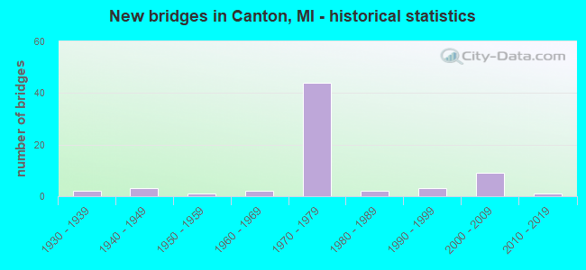
- New bridges - historical statistics
- 21930-1939
- 31940-1949
- 11950-1959
- 21960-1969
- 441970-1979
- 21980-1989
- 31990-1999
- 92000-2009
- 12010-2019

- Reconstructed bridges - Historical Statistics
- 11960-1969
- 01970-1979
- 11980-1989
- 31990-1999
- 62000-2009
- 02010-2019
- 12020-2022


- Bridge Condition - Deck
- 2.5%Excellent
- 12.5%Very good
- 50.0%Good
- 17.5%Satisfactory
- 10.0%Fair
- 2.5%Poor
- 5.0%Serious

- Bridge Condition - Superstructure
- 2.5%Excellent
- 27.5%Very good
- 45.0%Good
- 12.5%Satisfactory
- 5.0%Fair
- 2.5%Poor
- 5.0%Serious

- Bridge Condition - Substructure
- 2.5%Excellent
- 10.0%Very good
- 57.5%Good
- 17.5%Satisfactory
- 10.0%Fair
- 2.5%Poor

- Bridge Condition - Channel
- 2.4%Excellent
- 9.8%Very good
- 39.0%Good
- 14.6%Satisfactory
- 22.0%Fair
- 12.2%Poor

- Bridge Condition - Culverts
- 6.3%Excellent
- 25.0%Very good
- 25.0%Good
- 31.3%Satisfactory
- 6.3%Fair
- 6.3%Poor
Find on map >> Show street view
Structure Number: 11299, Location: 2.3 MI E OF WASHTENAW COL (Lat: 42.267583, Lng: -83.502736), Route carried "on" structure: US 12, Year Built: 2003, Status: Open, Structure Length: 0.97m (3.18ft), Average Daily Traffic: 7,495 (year 2007), Truck Traffic: 5%, Average Future Daily Traffic: 14,346 (year 2018), Features Intersected: APPLE RUN DRAIN
Minimum Vertical Clearance: 30.48m (100.00ft), Kilometerpoint: 4.059, Lanes on structure: 2, Base Highway Network: Yes (Inventory Route: 160, Subroute: 6), Owner: State Highway Agency, Approaching Roadway Width: 12.2m (40.0ft), Skew: 24 degrees, Material/Design: Concrete, Design/Construction: Culvert, Number Of Spans In Main Unit: 1, Length of Maximum Span: 8.8m (28.9ft), Curb-To-Curb Width: 15.8m (51.8ft), Out-to-Out Width: 25.0m (82.0ft)
Condition: Channel: Satisfactory, Culverts: Very good, Operating Rating: 54.1 metric tons, Method Used To Determine Operating Rating: Field evaluation and documented engineering judgment, Inventory Rating: 32.4 metric tons, Method Used To Determine Inventory Rating: Field evaluation and documented engineering judgment, Structural Evaluation: Equal to present desirable criteria, Deck Geometry: Superior to present desirable criteria, Waterway Adequacy: Equal to present desirable criteria, Approach Roadway Alignment: Equal to present desirable criteria, Designated Inspection Frequency: Every 24 months, Inspection Date: October 2020, Bridge Improvement Cost: $5,000, Deck Structure Type: Concrete Cast-file-Place, Wearing Surface/Protective System: Wearing Surface: Bituminous
Find on map >> Show street view
Structure Number: 113, Location: 2.5 MI E OF WASHTENAW COL (Lat: 42.268872, Lng: -83.498839), Route carried "on" structure: US 12, Year Built: 2003, Status: Open, Structure Length: 1.24m (4.07ft), Average Daily Traffic: 7,495 (year 2007), Truck Traffic: 5%, Average Future Daily Traffic: 14,346 (year 2018), Features Intersected: APPLE RUN DRAIN
Minimum Vertical Clearance: 30.48m (100.00ft), Kilometerpoint: 4.355, Lanes on structure: 2, Base Highway Network: Yes (Inventory Route: 470, Subroute: 65), Owner: State Highway Agency, Approaching Roadway Width: 12.2m (40.0ft), Skew: 4 degrees, Material/Design: Concrete, Design/Construction: Culvert, Number Of Spans In Main Unit: 1, Length of Maximum Span: 11.6m (38.1ft), Out-to-Out Width: 26.2m (86.0ft)
Condition: Channel: Very good, Culverts: Very good, Operating Rating: 54.1 metric tons, Method Used To Determine Operating Rating: Field evaluation and documented engineering judgment, Inventory Rating: 32.4 metric tons, Method Used To Determine Inventory Rating: Field evaluation and documented engineering judgment, Structural Evaluation: Equal to present desirable criteria, Waterway Adequacy: Equal to present desirable criteria, Approach Roadway Alignment: Equal to present desirable criteria, Designated Inspection Frequency: Every 24 months, Inspection Date: October 2020, Deck Structure Type: Concrete Cast-file-Place, Wearing Surface/Protective System: Wearing Surface: Bituminous
Find on map >> Show street view
Structure Number: 11327, Location: 3.3 MI E OF WASHTENAW COL (Lat: 42.322036, Lng: -83.483969), Route carried "on" structure: State highway 153, Year Built: 2006, Status: Open, Structure Length: 1.40m (4.59ft), Average Daily Traffic: 25,833 (year 2007), Truck Traffic: 2%, Average Future Daily Traffic: 49,000 (year 2025), Design Load: HS 25 or greater, Features Intersected: FELLOWS CREEK
Minimum Vertical Clearance: 30.48m (100.00ft), Kilometerpoint: 5.131, Lanes on structure: 5, Base Highway Network: Yes (Inventory Route: 159, Subroute: 10), Owner: State Highway Agency, Approaching Roadway Width: 24.4m (80.1ft), Skew: 2 degrees, Material/Design: Prestressed concrete, Design/Construction: Box Beam or Girders - Multiple, Number Of Spans In Main Unit: 1, Length of Maximum Span: 12.8m (42.0ft), Curb or Sidewalk Widths: Left: 3.8m (12.5ft), Right: 2.5m (8.2ft), Curb-To-Curb Width: 24.4m (80.1ft), Out-to-Out Width: 31.5m (103.3ft)
Condition: Deck: Good, Superstructure: Very good, Substructure: Very good, Channel: Good, Operating Rating: 97.2 metric tons, Method Used To Determine Operating Rating: Load Factor (LF) rating reported by rating factor (RF) method using MS18 loading, Inventory Rating: 66.7 metric tons, Method Used To Determine Inventory Rating: Load Factor (LF) rating reported by rating factor (RF) method using MS18 loading, Structural Evaluation: Equal to present desirable criteria, Deck Geometry: Superior to present desirable criteria, Waterway Adequacy: Equal to present desirable criteria, Approach Roadway Alignment: Equal to present desirable criteria, Designated Inspection Frequency: Every 24 months, Inspection Date: June 2021, Deck Structure Type: Concrete Cast-file-Place, Wearing Surface/Protective System: Wearing Surface: Integral Concrete, Deck Protection: Epoxy Coated Reinforcing
Find on map >> Show street view
Structure Number: 11918, Location: 2.5 MI W OF WAYNE (Lat: 42.282217, Lng: -83.443544), Route carried "on" structure: Ramp Interstate 275, Year Built: 1974, Year Reconstructed: 2006, Status: Open, Structure Length: 6.92m (22.70ft), Average Daily Traffic: 7,020 (year 1982), Truck Traffic: 3%, Average Future Daily Traffic: 7,020 (year 1977), Design Load: HS 25 or greater, Features Intersected: LOWER ROUGE R/BIKE PATH
Minimum Vertical Clearance: 30.48m (100.00ft), Kilometerpoint: 0.333, Lanes on structure: 1, Owner: State Highway Agency, Approaching Roadway Width: 7.6m (24.9ft), Skew: 3 degrees, Material/Design: Steel, Design/Construction: Stringer/Multi-beam, Number Of Spans In Main Unit: 4, Length of Maximum Span: 19.8m (65.0ft), Curb-To-Curb Width: 7.2m (23.6ft), Out-to-Out Width: 8.1m (26.6ft)
Condition: Deck: Good, Superstructure: Good, Substructure: Good, Channel: Satisfactory, Inventory Rating: 60.5 metric tons, Method Used To Determine Inventory Rating: Load Factor (LF), Structural Evaluation: Better than present minimum criteria, Deck Geometry: Equal to present minimum criteria, Waterway Adequacy: Equal to present desirable criteria, Approach Roadway Alignment: Equal to present desirable criteria, Designated Inspection Frequency: Every 24 months, Inspection Date: September 2021, Deck Structure Type: Concrete Cast-file-Place, Wearing Surface/Protective System: Wearing Surface: Latex Concrete
Find on map >> Show street view
Structure Number: 11919, Location: 2.5 MI W OF WAYNE (Lat: 42.282472, Lng: -83.442356), Route carried "on" structure: Interstate 275, Year Built: 1974, Status: Open, Structure Length: 7.26m (23.82ft), Average Daily Traffic: 53,635 (year 2007), Truck Traffic: 9%, Average Future Daily Traffic: 51,850 (year 2042), Design Load: HS 25 or greater, Features Intersected: LOWER ROUGE R/BIKE PATH
Minimum Vertical Clearance: 30.48m (100.00ft), Kilometerpoint: 23.377, Lanes on structure: 3, Base Highway Network: Yes (Inventory Route: 160, Subroute: 10), Owner: State Highway Agency, Approaching Roadway Width: 16.5m (54.1ft), Material/Design: Prestressed concrete, Design/Construction: Stringer/Multi-beam, Number Of Spans In Main Unit: 4, Length of Maximum Span: 20.5m (67.3ft), Curb-To-Curb Width: 16.0m (52.5ft), Out-to-Out Width: 17.0m (55.8ft)
Condition: Deck: Good, Superstructure: Good, Substructure: Good, Channel: Good, Operating Rating: 97.2 metric tons, Method Used To Determine Operating Rating: Load Factor (LF) rating reported by rating factor (RF) method using MS18 loading, Inventory Rating: 28.8 metric tons, Method Used To Determine Inventory Rating: Load Factor (LF) rating reported by rating factor (RF) method using MS18 loading, Structural Evaluation: Better than present minimum criteria, Deck Geometry: Equal to present minimum criteria, Waterway Adequacy: Equal to present desirable criteria, Approach Roadway Alignment: Equal to present desirable criteria, Designated Inspection Frequency: Every 24 months, Inspection Date: October 2020, Deck Structure Type: Concrete Cast-file-Place, Wearing Surface/Protective System: Wearing Surface: Latex Concrete
Find on map >> Show street view
Structure Number: 1192, Location: 2.5 MI W OF WAYNE (Lat: 42.282567, Lng: -83.441881), Route carried "on" structure: Interstate 275, Year Built: 1974, Status: Open, Structure Length: 7.26m (23.82ft), Average Daily Traffic: 53,635 (year 2007), Truck Traffic: 9%, Average Future Daily Traffic: 51,850 (year 2042), Design Load: HS 25 or greater, Features Intersected: LOWER ROUGE R/BIKE PATH
Minimum Vertical Clearance: 30.48m (100.00ft), Kilometerpoint: 23.375, Lanes on structure: 3, Base Highway Network: Yes (Inventory Route: 160, Subroute: 8), Owner: State Highway Agency, Approaching Roadway Width: 16.5m (54.1ft), Material/Design: Prestressed concrete, Design/Construction: Stringer/Multi-beam, Number Of Spans In Main Unit: 4, Length of Maximum Span: 20.5m (67.3ft), Curb-To-Curb Width: 18.3m (60.0ft), Out-to-Out Width: 19.3m (63.3ft)
Condition: Deck: Very good, Superstructure: Very good, Substructure: Good, Channel: Good, Operating Rating: 61.6 metric tons, Method Used To Determine Operating Rating: Load and Resistance Factor Rating (LRFR) rating reported by rating factor(RF) method using HL-93 loadings, Inventory Rating: 40.2 metric tons, Method Used To Determine Inventory Rating: Load and Resistance Factor Rating (LRFR) rating reported by rating factor(RF) method using HL-93 loadings, Structural Evaluation: Better than present minimum criteria, Deck Geometry: Better than present minimum criteria, Waterway Adequacy: Equal to present desirable criteria, Approach Roadway Alignment: Equal to present desirable criteria, Designated Inspection Frequency: Every 24 months, Inspection Date: October 2020, Deck Structure Type: Concrete Cast-file-Place, Wearing Surface/Protective System: Wearing Surface: Monolithic Concrete, Deck Protection: Epoxy Coated Reinforcing
Find on map >> Show street view
Structure Number: 11921, Location: 2.0 MI NW OF WAYNE (Lat: 42.306047, Lng: -83.442875), Route carried "on" structure: Interstate 275, Year Built: 1974, Status: Open, Structure Length: 3.23m (10.60ft), Average Daily Traffic: 50,325 (year 2007), Truck Traffic: 9%, Average Future Daily Traffic: 51,850 (year 2042), Design Load: HS 25 or greater, Features Intersected: FELLOWS CREEK
Minimum Vertical Clearance: 30.48m (100.00ft), Kilometerpoint: 26.016, Lanes on structure: 3, Base Highway Network: Yes (Inventory Route: 160, Subroute: 10), Owner: State Highway Agency, Approaching Roadway Width: 17.0m (55.8ft), Skew: 3 degrees, Material/Design: Steel, Design/Construction: Stringer/Multi-beam, Number Of Spans In Main Unit: 3, Length of Maximum Span: 11.5m (37.7ft), Curb-To-Curb Width: 16.2m (53.1ft), Out-to-Out Width: 17.2m (56.4ft)
Condition: Deck: Good, Superstructure: Very good, Substructure: Good, Channel: Fair, Operating Rating: 91.0 metric tons, Method Used To Determine Operating Rating: Load Factor (LF), Inventory Rating: 54.0 metric tons, Method Used To Determine Inventory Rating: Load Factor (LF), Structural Evaluation: Better than present minimum criteria, Deck Geometry: Equal to present minimum criteria, Waterway Adequacy: Equal to present desirable criteria, Approach Roadway Alignment: Equal to present desirable criteria, Designated Inspection Frequency: Every 24 months, Inspection Date: October 2020, Deck Structure Type: Concrete Cast-file-Place, Wearing Surface/Protective System: Wearing Surface: Epoxy Overlay
Find on map >> Show street view
Structure Number: 11922, Location: 0.25 MI W OF WAYNE (Lat: 42.282617, Lng: -83.441514), Route carried "on" structure: Ramp Interstate 275, Year Built: 1974, Status: Open, Structure Length: 7.39m (24.25ft), Average Daily Traffic: 7,020 (year 1982), Truck Traffic: 3%, Average Future Daily Traffic: 7,020 (year 1977), Design Load: HS 25 or greater, Features Intersected: LOWER ROUGE R/BIKE PATH
Minimum Vertical Clearance: 30.48m (100.00ft), Kilometerpoint: 0.369, Lanes on structure: 1, Owner: State Highway Agency, Approaching Roadway Width: 9.1m (29.9ft), Skew: 2 degrees, Material/Design: Steel, Design/Construction: Stringer/Multi-beam, Number Of Spans In Main Unit: 4, Length of Maximum Span: 22.6m (74.1ft), Curb-To-Curb Width: 7.2m (23.6ft), Out-to-Out Width: 8.1m (26.6ft)
Condition: Deck: Good, Superstructure: Good, Substructure: Good, Channel: Satisfactory, Operating Rating: 94.1 metric tons, Method Used To Determine Operating Rating: Load Factor (LF), Inventory Rating: 56.3 metric tons, Method Used To Determine Inventory Rating: Load Factor (LF), Structural Evaluation: Better than present minimum criteria, Deck Geometry: Equal to present minimum criteria, Waterway Adequacy: Equal to present desirable criteria, Approach Roadway Alignment: Somewhat better than minimum adequacy, Designated Inspection Frequency: Every 24 months, Inspection Date: October 2020, Deck Structure Type: Concrete Cast-file-Place, Wearing Surface/Protective System: Wearing Surface: Epoxy Overlay
Find on map >> Show street view
Structure Number: 11923, Location: 2.0 MI NW OF WAYNE (Lat: 42.305800, Lng: -83.442386), Route carried "on" structure: Interstate 275, Year Built: 1974, Year Reconstructed: 2012, Status: Open, Structure Length: 3.23m (10.60ft), Average Daily Traffic: 50,365 (year 2007), Truck Traffic: 9%, Average Future Daily Traffic: 51,850 (year 2042), Design Load: HS 25 or greater, Features Intersected: FELLOWS CREEK
Minimum Vertical Clearance: 30.48m (100.00ft), Kilometerpoint: 25.977, Lanes on structure: 3, Base Highway Network: Yes (Inventory Route: 160, Subroute: 8), Owner: State Highway Agency, Approaching Roadway Width: 15.2m (49.9ft), Skew: 3 degrees, Material/Design: Steel, Design/Construction: Stringer/Multi-beam, Number Of Spans In Main Unit: 3, Length of Maximum Span: 11.4m (37.4ft), Curb-To-Curb Width: 16.2m (53.1ft), Out-to-Out Width: 17.2m (56.4ft)
Condition: Deck: Good, Superstructure: Very good, Substructure: Good, Channel: Poor, Operating Rating: 90.8 metric tons, Method Used To Determine Operating Rating: Load Factor (LF), Inventory Rating: 54.2 metric tons, Method Used To Determine Inventory Rating: Load Factor (LF), Structural Evaluation: Better than present minimum criteria, Deck Geometry: Equal to present minimum criteria, Waterway Adequacy: Equal to present desirable criteria, Approach Roadway Alignment: Equal to present desirable criteria, Designated Inspection Frequency: Every 24 months, Inspection Date: October 2020, Deck Structure Type: Concrete Cast-file-Place, Wearing Surface/Protective System: Wearing Surface: Latex Concrete
Find on map >> Show street view
Structure Number: 11941, Location: 2.2 MI.W OF WAYNE (Lat: 42.268550, Lng: -83.441175), Route carried "on" structure: Interstate 275, Year Built: 1974, Status: Open, Structure Length: 4.73m (15.52ft), Average Daily Traffic: 48,903 (year 2007), Truck Traffic: 9%, Average Future Daily Traffic: 61,850 (year 2042), Design Load: HS 25 or greater, Features Intersected: MDOT RR CORRIDOR
Minimum Vertical Clearance: 30.48m (100.00ft), Kilometerpoint: 21.848, Lanes on structure: 3, Base Highway Network: Yes (Inventory Route: 160, Subroute: 10), Owner: State Highway Agency, Approaching Roadway Width: 15.2m (49.9ft), Skew: 1 degrees, Material/Design: Prestressed concrete, Design/Construction: Stringer/Multi-beam, Number Of Spans In Main Unit: 3, Length of Maximum Span: 15.8m (51.8ft), Curb-To-Curb Width: 16.0m (52.5ft), Out-to-Out Width: 17.0m (55.8ft)
Condition: Deck: Good, Superstructure: Very good, Substructure: Good, Operating Rating: 76.1 metric tons, Method Used To Determine Operating Rating: Load Factor (LF) rating reported by rating factor (RF) method using MS18 loading, Inventory Rating: 33.7 metric tons, Method Used To Determine Inventory Rating: Load Factor (LF) rating reported by rating factor (RF) method using MS18 loading, Structural Evaluation: Better than present minimum criteria, Deck Geometry: Equal to present minimum criteria, Approach Roadway Alignment: Equal to present desirable criteria, Designated Inspection Frequency: Every 24 months, Inspection Date: June 2021, Deck Structure Type: Concrete Cast-file-Place, Wearing Surface/Protective System: Wearing Surface: Epoxy Overlay
Find on map >> Show street view
Structure Number: 11942, Location: 2.2 MI W OF WAYNE (Lat: 42.268617, Lng: -83.440694), Route carried "on" structure: Interstate 275, Year Built: 1974, Year Reconstructed: 2012, Status: Open, Structure Length: 4.73m (15.52ft), Average Daily Traffic: 48,903 (year 2007), Truck Traffic: 9%, Average Future Daily Traffic: 61,850 (year 2042), Design Load: HS 25 or greater, Features Intersected: MDOT RR CORRIDOR
Minimum Vertical Clearance: 30.48m (100.00ft), Kilometerpoint: 21.844, Lanes on structure: 3, Base Highway Network: Yes (Inventory Route: 160, Subroute: 8), Owner: State Highway Agency, Approaching Roadway Width: 15.2m (49.9ft), Material/Design: Prestressed concrete, Design/Construction: Stringer/Multi-beam, Number Of Spans In Main Unit: 3, Length of Maximum Span: 15.8m (51.8ft), Curb or Sidewalk Widths: Left: 0.0m, Right: 2.1m (6.9ft), Curb-To-Curb Width: 16.0m (52.5ft), Out-to-Out Width: 19.2m (63.0ft)
Condition: Deck: Good, Superstructure: Very good, Substructure: Good, Operating Rating: 61.9 metric tons, Method Used To Determine Operating Rating: Load Factor (LF) rating reported by rating factor (RF) method using MS18 loading, Inventory Rating: 24.3 metric tons, Method Used To Determine Inventory Rating: Load Factor (LF) rating reported by rating factor (RF) method using MS18 loading, Structural Evaluation: Equal to present minimum criteria, Deck Geometry: Equal to present minimum criteria, Underclear: Equal to present minimum criteria, Approach Roadway Alignment: Equal to present desirable criteria, Designated Inspection Frequency: Every 24 months, Inspection Date: June 2021, Deck Structure Type: Concrete Cast-file-Place, Wearing Surface/Protective System: Wearing Surface: Latex Concrete
Find on map >> Show street view
Structure Number: 11946, Location: 2.2 MI W OF WAYNE (Lat: 42.264850, Lng: -83.440978), Route carried "on" structure: Interstate 275, Year Built: 1974, Status: Open, Structure Length: 3.66m (12.01ft), Average Daily Traffic: 78,900 (year 2012), Truck Traffic: 9%, Average Future Daily Traffic: 51,850 (year 2042), Design Load: HS 25 or greater, Features Intersected: VAN BORN ROAD
Minimum Vertical Clearance: 30.48m (100.00ft), Kilometerpoint: 21.421, Lanes on structure: 3, Lanes under structure: 2, Base Highway Network: Yes (Inventory Route: 160, Subroute: 10), Owner: State Highway Agency, Approaching Roadway Width: 16.5m (54.1ft), Material/Design: Steel, Design/Construction: Stringer/Multi-beam, Number Of Spans In Main Unit: 1, Length of Maximum Span: 35.5m (116.5ft), Curb-To-Curb Width: 16.0m (52.5ft), Out-to-Out Width: 17.0m (55.8ft)
Condition: Deck: Good, Superstructure: Good, Substructure: Good, Operating Rating: 90.4 metric tons, Method Used To Determine Operating Rating: Load Factor (LF) rating reported by rating factor (RF) method using MS18 loading, Inventory Rating: 54.1 metric tons, Method Used To Determine Inventory Rating: Load Factor (LF) rating reported by rating factor (RF) method using MS18 loading, Structural Evaluation: Better than present minimum criteria, Deck Geometry: Equal to present minimum criteria, Underclear: High priority of corrective action, Approach Roadway Alignment: Equal to present desirable criteria, Designated Inspection Frequency: Every 24 months, Inspection Date: August 2020, Deck Structure Type: Concrete Cast-file-Place, Wearing Surface/Protective System: Wearing Surface: Epoxy Overlay
Find on map >> Show street view
Structure Number: 11947, Location: 3/4 MI W OF W OF LI WAYNE (Lat: 42.280053, Lng: -83.441747), Route carried "on" structure: Interstate 275, Year Built: 1974, Status: Open, Structure Length: 8.20m (26.90ft), Average Daily Traffic: 48,903 (year 2007), Truck Traffic: 9%, Average Future Daily Traffic: 51,850 (year 2042), Design Load: HS 25 or greater, Features Intersected: MICHIGAN AVE(US-12)
Minimum Vertical Clearance: 30.48m (100.00ft), Kilometerpoint: 23.103, Lanes on structure: 3, Lanes under structure: 8, Base Highway Network: Yes (Inventory Route: 160, Subroute: 10), Owner: State Highway Agency, Approaching Roadway Width: 19.2m (63.0ft), Material/Design: Steel, Design/Construction: Stringer/Multi-beam, Number Of Spans In Main Unit: 2, Length of Maximum Span: 41.8m (137.1ft), Curb-To-Curb Width: 18.3m (60.0ft), Out-to-Out Width: 19.4m (63.6ft)
Condition: Deck: Good, Superstructure: Good, Substructure: Good, Operating Rating: 97.2 metric tons, Method Used To Determine Operating Rating: Load Factor (LF), Inventory Rating: 58.2 metric tons, Method Used To Determine Inventory Rating: Load Factor (LF), Structural Evaluation: Better than present minimum criteria, Deck Geometry: Better than present minimum criteria, Underclear: Better than present minimum criteria, Approach Roadway Alignment: Equal to present desirable criteria, Designated Inspection Frequency: Every 24 months, Inspection Date: October 2020, Deck Structure Type: Concrete Cast-file-Place, Wearing Surface/Protective System: Wearing Surface: Epoxy Overlay
Find on map >> Show street view
Structure Number: 11948, Location: 1 MI NW OF WAYNE (Lat: 42.293897, Lng: -83.443131), Route carried "on" structure: County highway 2057, Year Built: 1974, Status: Open, Structure Length: 8.93m (29.30ft), Average Daily Traffic: 3,948 (year 1994), Truck Traffic: 6%, Average Future Daily Traffic: 7,000 (year 2017), Design Load: HS 20, Features Intersected: I-275, Facility Carried by Structure: PALMER RD
Minimum Vertical Clearance: 30.48m (100.00ft), Kilometerpoint: 3.558, Lanes on structure: 2, Lanes under structure: 6, Owner: State Highway Agency, Approaching Roadway Width: 12.3m (40.4ft), Material/Design: Steel, Design/Construction: Stringer/Multi-beam, Number Of Spans In Main Unit: 2, Length of Maximum Span: 45.3m (148.6ft), Curb-To-Curb Width: 13.6m (44.6ft), Out-to-Out Width: 14.8m (48.6ft)
Condition: Deck: Good, Superstructure: Satisfactory, Substructure: Satisfactory, Operating Rating: 90.4 metric tons, Method Used To Determine Operating Rating: Load Factor (LF), Inventory Rating: 54.1 metric tons, Method Used To Determine Inventory Rating: Load Factor (LF), Structural Evaluation: Equal to present minimum criteria, Deck Geometry: Superior to present desirable criteria, Underclear: Somewhat better than minimum adequacy, Approach Roadway Alignment: Equal to present desirable criteria, Designated Inspection Frequency: Every 24 months, Inspection Date: October 2020, Deck Structure Type: Concrete Cast-file-Place, Wearing Surface/Protective System: Wearing Surface: Monolithic Concrete
Find on map >> Show street view
Structure Number: 11949, Location: 2 MI NW OF WAYNE (Lat: 42.308619, Lng: -83.442167), Route carried "on" structure: County highway 2057, Year Built: 1974, Status: Open, Structure Length: 8.84m (29.00ft), Average Daily Traffic: 16,165 (year 1996), Truck Traffic: 8%, Average Future Daily Traffic: 27,000 (year 2017), Design Load: HS 20, Features Intersected: I-275, Facility Carried by Structure: CHERRY HILL RD
Minimum Vertical Clearance: 30.48m (100.00ft), Kilometerpoint: 8.496, Lanes on structure: 2, Lanes under structure: 6, Owner: State Highway Agency, Approaching Roadway Width: 12.3m (40.4ft), Material/Design: Steel, Design/Construction: Stringer/Multi-beam, Number Of Spans In Main Unit: 2, Length of Maximum Span: 44.4m (145.7ft), Curb-To-Curb Width: 13.6m (44.6ft), Out-to-Out Width: 14.8m (48.6ft)
Condition: Deck: Good, Superstructure: Good, Substructure: Good, Inventory Rating: 61.6 metric tons, Method Used To Determine Inventory Rating: Load Factor (LF), Structural Evaluation: Better than present minimum criteria, Deck Geometry: Superior to present desirable criteria, Underclear: Somewhat better than minimum adequacy, Approach Roadway Alignment: Equal to present desirable criteria, Designated Inspection Frequency: Every 24 months, Inspection Date: October 2020, Deck Structure Type: Concrete Cast-file-Place, Wearing Surface/Protective System: Wearing Surface: Monolithic Concrete
Find on map >> Show street view
Structure Number: 1195, Location: 5 MI W OF GARDEN CITY (Lat: 42.323119, Lng: -83.443528), Route carried "on" structure: Interstate 275, Year Built: 1972, Status: Open, Structure Length: 5.49m (18.01ft), Average Daily Traffic: 63,759 (year 2007), Truck Traffic: 7%, Average Future Daily Traffic: 51,850 (year 2042), Design Load: HS 20, Features Intersected: M-153 (FORD RD)
Minimum Vertical Clearance: 30.48m (100.00ft), Kilometerpoint: 27.913, Lanes on structure: 4, Lanes under structure: 6, Base Highway Network: Yes (Inventory Route: 160, Subroute: 10), Owner: State Highway Agency, Approaching Roadway Width: 18.9m (62.0ft), Material/Design: Steel, Design/Construction: Stringer/Multi-beam, Number Of Spans In Main Unit: 2, Length of Maximum Span: 27.3m (89.6ft), Curb-To-Curb Width: 18.7m (61.4ft), Out-to-Out Width: 19.7m (64.6ft)
Condition: Deck: Good, Superstructure: Satisfactory, Substructure: Fair, Operating Rating: 94.9 metric tons, Method Used To Determine Operating Rating: Load Factor (LF), Inventory Rating: 56.8 metric tons, Method Used To Determine Inventory Rating: Load Factor (LF), Structural Evaluation: Somewhat better than minimum adequacy, Deck Geometry: Meets minimum limits, Underclear: Equal to present minimum criteria, Approach Roadway Alignment: Equal to present desirable criteria, Designated Inspection Frequency: Every 24 months, Inspection Date: October 2020, Deck Structure Type: Concrete Cast-file-Place, Wearing Surface/Protective System: Wearing Surface: Epoxy Overlay
Find on map >> Show street view
Structure Number: 11951, Location: 2.2 MI W OF WAYNE (Lat: 42.264861, Lng: -83.440503), Route carried "on" structure: Interstate 275, Year Built: 1974, Status: Open, Structure Length: 3.66m (12.01ft), Average Daily Traffic: 48,903 (year 2007), Truck Traffic: 9%, Average Future Daily Traffic: 51,850 (year 2042), Design Load: HS 25 or greater, Features Intersected: VANBORN ROAD
Minimum Vertical Clearance: 30.48m (100.00ft), Kilometerpoint: 21.410, Lanes on structure: 3, Lanes under structure: 2, Base Highway Network: Yes (Inventory Route: 160, Subroute: 8), Owner: State Highway Agency, Approaching Roadway Width: 16.5m (54.1ft), Material/Design: Steel, Design/Construction: Stringer/Multi-beam, Number Of Spans In Main Unit: 1, Length of Maximum Span: 35.5m (116.5ft), Curb-To-Curb Width: 16.0m (52.5ft), Out-to-Out Width: 17.0m (55.8ft)
Condition: Deck: Good, Superstructure: Very good, Substructure: Good, Operating Rating: 97.2 metric tons, Method Used To Determine Operating Rating: Load Factor (LF) rating reported by rating factor (RF) method using MS18 loading, Inventory Rating: 65.8 metric tons, Method Used To Determine Inventory Rating: Load Factor (LF) rating reported by rating factor (RF) method using MS18 loading, Structural Evaluation: Better than present minimum criteria, Deck Geometry: Equal to present minimum criteria, Underclear: Somewhat better than minimum adequacy, Approach Roadway Alignment: Equal to present desirable criteria, Designated Inspection Frequency: Every 24 months, Inspection Date: August 2020, Deck Structure Type: Concrete Cast-file-Place, Wearing Surface/Protective System: Wearing Surface: Epoxy Overlay
Find on map >> Show street view
Structure Number: 11952, Location: 3/4 MI W OF WAYNE C LTS (Lat: 42.280111, Lng: -83.441225), Route carried "on" structure: Interstate 275, Year Built: 1974, Status: Open, Structure Length: 8.20m (26.90ft), Average Daily Traffic: 48,903 (year 2007), Truck Traffic: 9%, Average Future Daily Traffic: 51,850 (year 2042), Design Load: HS 25 or greater, Features Intersected: MICHIGAN AVE(US-12)
Minimum Vertical Clearance: 30.48m (100.00ft), Kilometerpoint: 23.096, Lanes on structure: 4, Lanes under structure: 9, Base Highway Network: Yes (Inventory Route: 160, Subroute: 8), Owner: State Highway Agency, Approaching Roadway Width: 19.2m (63.0ft), Material/Design: Steel, Design/Construction: Stringer/Multi-beam, Number Of Spans In Main Unit: 2, Length of Maximum Span: 41.8m (137.1ft), Curb-To-Curb Width: 18.4m (60.4ft), Out-to-Out Width: 19.4m (63.6ft)
Condition: Deck: Good, Superstructure: Good, Substructure: Good, Operating Rating: 96.7 metric tons, Method Used To Determine Operating Rating: Load Factor (LF), Inventory Rating: 57.9 metric tons, Method Used To Determine Inventory Rating: Load Factor (LF), Structural Evaluation: Better than present minimum criteria, Deck Geometry: Meets minimum limits, Underclear: Better than present minimum criteria, Approach Roadway Alignment: Equal to present desirable criteria, Designated Inspection Frequency: Every 24 months, Inspection Date: October 2020, Deck Structure Type: Concrete Cast-file-Place, Wearing Surface/Protective System: Wearing Surface: Epoxy Overlay
Find on map >> Show street view
Structure Number: 11953, Location: 5 MI W OF GARDEN CITY (Lat: 42.323136, Lng: -83.443050), Route carried "on" structure: Interstate 275, Year Built: 1972, Status: Open, Structure Length: 5.49m (18.01ft), Average Daily Traffic: 63,759 (year 2007), Truck Traffic: 7%, Average Future Daily Traffic: 51,800 (year 2042), Design Load: HS 20+Mod, Features Intersected: M-153 (FORD RD)
Minimum Vertical Clearance: 30.48m (100.00ft), Kilometerpoint: 27.902, Lanes on structure: 4, Lanes under structure: 6, Base Highway Network: Yes (Inventory Route: 160, Subroute: 8), Owner: State Highway Agency, Approaching Roadway Width: 18.0m (59.1ft), Material/Design: Steel, Design/Construction: Stringer/Multi-beam, Number Of Spans In Main Unit: 2, Length of Maximum Span: 27.3m (89.6ft), Curb-To-Curb Width: 18.7m (61.4ft), Out-to-Out Width: 19.7m (64.6ft)
Condition: Deck: Satisfactory, Superstructure: Good, Substructure: Satisfactory, Operating Rating: 78.7 metric tons, Method Used To Determine Operating Rating: Load Factor (LF), Inventory Rating: 47.1 metric tons, Method Used To Determine Inventory Rating: Load Factor (LF), Structural Evaluation: Equal to present minimum criteria, Deck Geometry: Meets minimum limits, Underclear: Equal to present minimum criteria, Approach Roadway Alignment: Equal to present desirable criteria, Designated Inspection Frequency: Every 24 months, Inspection Date: October 2020, Deck Structure Type: Concrete Cast-file-Place, Wearing Surface/Protective System: Wearing Surface: Epoxy Overlay
Find on map >> Show street view
Structure Number: 11954, Location: 3.5 MI SE OF PLYMOUTH (Lat: 42.334975, Lng: -83.443606), Route carried "on" structure: Interstate 275, Year Built: 1972, Status: Open, Structure Length: 1.07m (3.51ft), Average Daily Traffic: 63,759 (year 2007), Truck Traffic: 7%, Average Future Daily Traffic: 70,250 (year 2042), Design Load: HS 20+Mod, Features Intersected: TONQUISH CR
Minimum Vertical Clearance: 30.48m (100.00ft), Kilometerpoint: 29.230, Lanes on structure: 3, Base Highway Network: Yes (Inventory Route: 160, Subroute: 10), Owner: State Highway Agency, Approaching Roadway Width: 18.2m (59.7ft), Material/Design: Prestressed concrete, Design/Construction: Stringer/Multi-beam, Number Of Spans In Main Unit: 1, Length of Maximum Span: 9.6m (31.5ft), Curb-To-Curb Width: 16.0m (52.5ft), Out-to-Out Width: 17.0m (55.8ft)
Condition: Deck: Good, Superstructure: Very good, Substructure: Good, Channel: Fair, Operating Rating: 75.8 metric tons, Method Used To Determine Operating Rating: Load Factor (LF) rating reported by rating factor (RF) method using MS18 loading, Inventory Rating: 45.4 metric tons, Method Used To Determine Inventory Rating: Load Factor (LF) rating reported by rating factor (RF) method using MS18 loading, Structural Evaluation: Better than present minimum criteria, Deck Geometry: Equal to present minimum criteria, Waterway Adequacy: Equal to present desirable criteria, Approach Roadway Alignment: Equal to present desirable criteria, Designated Inspection Frequency: Every 24 months, Inspection Date: October 2020, Deck Structure Type: Concrete Cast-file-Place, Wearing Surface/Protective System: Wearing Surface: Epoxy Overlay
Find on map >> Show street view
Structure Number: 11957, Location: 3.5 MI SE OF PLYMOUTH (Lat: 42.334967, Lng: -83.443111), Route carried "on" structure: Interstate 275, Year Built: 1972, Status: Open, Structure Length: 1.07m (3.51ft), Average Daily Traffic: 63,759 (year 2007), Truck Traffic: 7%, Average Future Daily Traffic: 76,050 (year 2042), Design Load: HS 20+Mod, Features Intersected: TONQUISH CR
Minimum Vertical Clearance: 30.48m (100.00ft), Kilometerpoint: 29.217, Lanes on structure: 3, Base Highway Network: Yes (Inventory Route: 160, Subroute: 8), Owner: State Highway Agency, Approaching Roadway Width: 18.2m (59.7ft), Material/Design: Prestressed concrete, Design/Construction: Stringer/Multi-beam, Number Of Spans In Main Unit: 1, Length of Maximum Span: 9.6m (31.5ft), Curb-To-Curb Width: 16.0m (52.5ft), Out-to-Out Width: 17.0m (55.8ft)
Condition: Deck: Very good, Superstructure: Very good, Substructure: Good, Channel: Good, Operating Rating: 75.8 metric tons, Method Used To Determine Operating Rating: Load Factor (LF) rating reported by rating factor (RF) method using MS18 loading, Inventory Rating: 45.4 metric tons, Method Used To Determine Inventory Rating: Load Factor (LF) rating reported by rating factor (RF) method using MS18 loading, Structural Evaluation: Better than present minimum criteria, Deck Geometry: Equal to present minimum criteria, Waterway Adequacy: Equal to present desirable criteria, Approach Roadway Alignment: Equal to present desirable criteria, Designated Inspection Frequency: Every 24 months, Inspection Date: October 2020, Deck Structure Type: Concrete Cast-file-Place, Wearing Surface/Protective System: Wearing Surface: Epoxy Overlay
Find on map >> Show street view
Structure Number: 11959, Location: 1 MI W OF LIVONIA (Lat: 42.343369, Lng: -83.440886), Route carried "on" structure: Interstate 275, Year Built: 1972, Year Reconstructed: 2012, Status: Open, Structure Length: 6.28m (20.60ft), Average Daily Traffic: 63,759 (year 2007), Truck Traffic: 7%, Average Future Daily Traffic: 76,050 (year 2042), Design Load: HS 20, Features Intersected: CSX RR
Minimum Vertical Clearance: 30.48m (100.00ft), Kilometerpoint: 30.170, Lanes on structure: 3, Base Highway Network: Yes (Inventory Route: 160, Subroute: 8), Owner: State Highway Agency, Approaching Roadway Width: 16.2m (53.1ft), Skew: 4 degrees, Material/Design: Steel, Design/Construction: Stringer/Multi-beam, Number Of Spans In Main Unit: 3, Length of Maximum Span: 22.4m (73.5ft), Curb-To-Curb Width: 17.7m (58.1ft), Out-to-Out Width: 18.7m (61.4ft)
Condition: Deck: Very good, Superstructure: Good, Substructure: Good, Operating Rating: 77.5 metric tons, Method Used To Determine Operating Rating: Load Factor (LF), Inventory Rating: 46.4 metric tons, Method Used To Determine Inventory Rating: Load Factor (LF), Structural Evaluation: Better than present minimum criteria, Deck Geometry: Better than present minimum criteria, Underclear: Better than present minimum criteria, Approach Roadway Alignment: Equal to present desirable criteria, Designated Inspection Frequency: Every 24 months, Inspection Date: October 2020, Deck Structure Type: Concrete Cast-file-Place, Wearing Surface/Protective System: Wearing Surface: Monolithic Concrete, Deck Protection: Epoxy Coated Reinforcing
Find on map >> Show street view
Structure Number: 11961, Location: 1.0 MI W OF LIVONIA (Lat: 42.343794, Lng: -83.441236), Route carried "on" structure: Interstate 275, Year Built: 1972, Year Reconstructed: 2012, Status: Open, Structure Length: 6.28m (20.60ft), Average Daily Traffic: 63,759 (year 2007), Truck Traffic: 7%, Average Future Daily Traffic: 70,250 (year 2042), Design Load: HS 20, Features Intersected: CSX RR
Minimum Vertical Clearance: 30.48m (100.00ft), Kilometerpoint: 30.231, Lanes on structure: 3, Base Highway Network: Yes (Inventory Route: 160, Subroute: 10), Owner: State Highway Agency, Approaching Roadway Width: 16.2m (53.1ft), Skew: 4 degrees, Material/Design: Steel, Design/Construction: Stringer/Multi-beam, Number Of Spans In Main Unit: 3, Length of Maximum Span: 22.4m (73.5ft), Curb-To-Curb Width: 17.7m (58.1ft), Out-to-Out Width: 18.7m (61.4ft)
Condition: Deck: Very good, Superstructure: Good, Substructure: Satisfactory, Operating Rating: 77.5 metric tons, Method Used To Determine Operating Rating: Load Factor (LF), Inventory Rating: 46.4 metric tons, Method Used To Determine Inventory Rating: Load Factor (LF), Structural Evaluation: Equal to present minimum criteria, Deck Geometry: Better than present minimum criteria, Underclear: Better than present minimum criteria, Approach Roadway Alignment: Equal to present desirable criteria, Designated Inspection Frequency: Every 24 months, Inspection Date: October 2020, Deck Structure Type: Concrete Cast-file-Place, Wearing Surface/Protective System: Wearing Surface: Monolithic Concrete, Deck Protection: Epoxy Coated Reinforcing
Find on map >> Show street view
Structure Number: 11964, Location: 3 MI SE OF PLYMOUTH (Lat: 42.332508, Lng: -83.442947), Route carried "on" structure: County highway 2057, Year Built: 1972, Year Reconstructed: 2012, Status: Open, Structure Length: 9.94m (32.61ft), Average Daily Traffic: 17,481 (year 1997), Truck Traffic: 8%, Average Future Daily Traffic: 17,200 (year 2042), Design Load: HS 20, Features Intersected: I-275, Facility Carried by Structure: WARREN RD
Minimum Vertical Clearance: 30.48m (100.00ft), Kilometerpoint: 8.696, Lanes on structure: 2, Lanes under structure: 6, Owner: State Highway Agency, Approaching Roadway Width: 15.8m (51.8ft), Skew: 1 degrees, Material/Design: Steel, Design/Construction: Stringer/Multi-beam, Number Of Spans In Main Unit: 4, Length of Maximum Span: 38.1m (125.0ft), Curb or Sidewalk Widths: Left: 0.0m, Right: 4.3m (14.1ft), Curb-To-Curb Width: 15.8m (51.8ft), Out-to-Out Width: 21.1m (69.2ft)
Condition: Deck: Very good, Superstructure: Very good, Substructure: Good, Operating Rating: 90.1 metric tons, Method Used To Determine Operating Rating: Load Factor (LF) rating reported by rating factor (RF) method using MS18 loading, Inventory Rating: 54.1 metric tons, Method Used To Determine Inventory Rating: Load Factor (LF) rating reported by rating factor (RF) method using MS18 loading, Structural Evaluation: Better than present minimum criteria, Deck Geometry: Superior to present desirable criteria, Underclear: Better than present minimum criteria, Approach Roadway Alignment: Equal to present desirable criteria, Designated Inspection Frequency: Every 24 months, Inspection Date: October 2020, Deck Structure Type: Concrete Cast-file-Place, Wearing Surface/Protective System: Wearing Surface: Monolithic Concrete, Deck Protection: Epoxy Coated Reinforcing
Find on map >> Show street view
Structure Number: 11979, Location: 1 MI W OF LIVONIA LTS (Lat: 42.341308, Lng: -83.442236), Route carried "on" structure: Interstate 275, Year Built: 1972, Status: Open, Structure Length: 3.00m (9.84ft), Average Daily Traffic: 63,759 (year 2007), Truck Traffic: 7%, Average Future Daily Traffic: 70,250 (year 2042), Design Load: HS 20, Features Intersected: KOPPERNICK RD
Minimum Vertical Clearance: 30.48m (100.00ft), Kilometerpoint: 29.943, Lanes on structure: 3, Lanes under structure: 2, Base Highway Network: Yes (Inventory Route: 160, Subroute: 10), Owner: State Highway Agency, Approaching Roadway Width: 15.0m (49.2ft), Skew: 1 degrees, Material/Design: Steel, Design/Construction: Stringer/Multi-beam, Number Of Spans In Main Unit: 1, Length of Maximum Span: 28.9m (94.8ft), Curb-To-Curb Width: 16.2m (53.1ft), Out-to-Out Width: 17.2m (56.4ft)
Condition: Deck: Fair, Superstructure: Fair, Substructure: Satisfactory, Operating Rating: 80.4 metric tons, Method Used To Determine Operating Rating: Load Factor (LF) rating reported by rating factor (RF) method using MS18 loading, Inventory Rating: 48.3 metric tons, Method Used To Determine Inventory Rating: Load Factor (LF) rating reported by rating factor (RF) method using MS18 loading, Structural Evaluation: Somewhat better than minimum adequacy, Deck Geometry: Equal to present minimum criteria, Underclear: Somewhat better than minimum adequacy, Approach Roadway Alignment: Equal to present desirable criteria, Designated Inspection Frequency: Every 24 months, Inspection Date: November 2020, Deck Structure Type: Concrete Cast-file-Place, Wearing Surface/Protective System: Wearing Surface: Epoxy Overlay
Find on map >> Show street view
Structure Number: 1198, Location: 1 MI W OF LIVONIA (Lat: 42.341319, Lng: -83.441717), Route carried "on" structure: Interstate 275, Year Built: 1972, Status: Open, Structure Length: 3.00m (9.84ft), Average Daily Traffic: 63,759 (year 2007), Truck Traffic: 7%, Average Future Daily Traffic: 76,050 (year 2042), Design Load: HS 20, Features Intersected: KOPPERNICK RD
Minimum Vertical Clearance: 30.48m (100.00ft), Kilometerpoint: 29.932, Lanes on structure: 3, Lanes under structure: 2, Base Highway Network: Yes (Inventory Route: 160, Subroute: 8), Owner: State Highway Agency, Approaching Roadway Width: 15.0m (49.2ft), Skew: 1 degrees, Material/Design: Steel, Design/Construction: Stringer/Multi-beam, Number Of Spans In Main Unit: 1, Length of Maximum Span: 28.9m (94.8ft), Curb-To-Curb Width: 16.2m (53.1ft), Out-to-Out Width: 17.2m (56.4ft)
Condition: Deck: Satisfactory, Superstructure: Good, Substructure: Good, Operating Rating: 80.7 metric tons, Method Used To Determine Operating Rating: Load Factor (LF) rating reported by rating factor (RF) method using MS18 loading, Inventory Rating: 48.3 metric tons, Method Used To Determine Inventory Rating: Load Factor (LF) rating reported by rating factor (RF) method using MS18 loading, Structural Evaluation: Better than present minimum criteria, Deck Geometry: Equal to present minimum criteria, Underclear: Somewhat better than minimum adequacy, Approach Roadway Alignment: Equal to present desirable criteria, Designated Inspection Frequency: Every 24 months, Inspection Date: November 2020, Deck Structure Type: Concrete Cast-file-Place, Wearing Surface/Protective System: Wearing Surface: Epoxy Overlay
Find on map >> Show street view
Structure Number: 12045, Location: CANTON W/BARR (Lat: 42.277058, Lng: -83.538767), Route carried "on" structure: County highway 2057, Year Built: 2001, Status: Open, Structure Length: 0.80m (2.62ft), Average Daily Traffic: 5,404 (year 2000), Truck Traffic: 1%, Average Future Daily Traffic: 6,215 (year 2020), Design Load: H 10, Features Intersected: FOWLER DRAIN, Facility Carried by Structure: GEDDES ROAD
Minimum Vertical Clearance: 30.48m (100.00ft), Kilometerpoint: 1.259, Lanes on structure: 2, Owner: County Highway Agency, Approaching Roadway Width: 12.2m (40.0ft), Material/Design: Concrete, Design/Construction: Culvert, Number Of Spans In Main Unit: 1, Length of Maximum Span: 7.4m (24.3ft), Curb-To-Curb Width: 9.7m (31.8ft), Out-to-Out Width: 12.8m (42.0ft)
Condition: Channel: Fair, Culverts: Good, Operating Rating: 62.5 metric tons, Method Used To Determine Operating Rating: Load Factor (LF) rating reported by rating factor (RF) method using MS18 loading, Inventory Rating: 37.3 metric tons, Method Used To Determine Inventory Rating: Load Factor (LF) rating reported by rating factor (RF) method using MS18 loading, Structural Evaluation: Better than present minimum criteria, Deck Geometry: High priority of corrective action, Waterway Adequacy: Equal to present desirable criteria, Approach Roadway Alignment: Equal to present desirable criteria, Designated Inspection Frequency: Every 24 months, Inspection Date: June 2021
Find on map >> Show street view
Structure Number: 12046, Location: CANTON W/CANTON CENTER (Lat: 42.277811, Lng: -83.492619), Route carried "on" structure: County highway 2057, Year Built: 1997, Status: Open, Structure Length: 0.73m (2.40ft), Average Daily Traffic: 8,349 (year 1997), Truck Traffic: 3%, Average Future Daily Traffic: 8,114 (year 2015), Design Load: HS 25 or greater, Features Intersected: SINES DRAIN, Facility Carried by Structure: GEDDES ROAD
Minimum Vertical Clearance: 30.48m (100.00ft), Kilometerpoint: 5.071, Lanes on structure: 2, Owner: County Highway Agency, Approaching Roadway Width: 11.6m (38.1ft), Material/Design: Prestressed concrete, Design/Construction: Box Beam or Girders - Multiple, Number Of Spans In Main Unit: 1, Length of Maximum Span: 6.1m (20.0ft), Curb or Sidewalk Widths: Left: 2.5m (8.2ft), Right: 2.5m (8.2ft), Curb-To-Curb Width: 9.2m (30.2ft), Out-to-Out Width: 13.4m (44.0ft)
Condition: Deck: Fair, Superstructure: Satisfactory, Substructure: Good, Channel: Good, Operating Rating: 97.2 metric tons, Method Used To Determine Operating Rating: Load Factor (LF) rating reported by rating factor (RF) method using MS18 loading, Inventory Rating: 97.2 metric tons, Method Used To Determine Inventory Rating: Load Factor (LF) rating reported by rating factor (RF) method using MS18 loading, Structural Evaluation: Equal to present minimum criteria, Deck Geometry: High priority of corrective action, Waterway Adequacy: Equal to present desirable criteria, Approach Roadway Alignment: Equal to present desirable criteria, Designated Inspection Frequency: Every 12 months, Inspection Date: May 2021, Deck Structure Type: Concrete Cast-file-Place, Wearing Surface/Protective System: Wearing Surface: Integral Concrete, Deck Protection: Epoxy Coated Reinforcing
Find on map >> Show street view
Structure Number: 12048, Location: CANTON W/I-275 (Lat: 42.308581, Lng: -83.443869), Route carried "on" structure: County highway 2057, Year Built: 1975, Status: Posted for load, Structure Length: 4.08m (13.39ft), Average Daily Traffic: 16,165 (year 1996), Truck Traffic: 3%, Average Future Daily Traffic: 17,390 (year 2015), Design Load: HS 20+Mod, Features Intersected: FELLOWS CREEK, Facility Carried by Structure: CHERRY HILL ROAD
Minimum Vertical Clearance: 30.48m (100.00ft), Kilometerpoint: 8.372, Lanes on structure: 2, Owner: County Highway Agency, Approaching Roadway Width: 12.2m (40.0ft), Material/Design: Steel, Design/Construction: Stringer/Multi-beam, Number Of Spans In Main Unit: 3, Length of Maximum Span: 15.2m (49.9ft), Curb or Sidewalk Widths: Left: 0.2m (0.7ft), Right: 0.2m (0.7ft), Curb-To-Curb Width: 13.5m (44.3ft), Out-to-Out Width: 14.7m (48.2ft)
Condition: Deck: Satisfactory, Superstructure: Satisfactory, Substructure: Very good, Channel: Good, Operating Rating: 58.0 metric tons, Method Used To Determine Operating Rating: Load Factor (LF) rating reported by rating factor (RF) method using MS18 loading, Inventory Rating: 34.7 metric tons, Method Used To Determine Inventory Rating: Load Factor (LF) rating reported by rating factor (RF) method using MS18 loading, Structural Evaluation: Equal to present minimum criteria, Deck Geometry: Superior to present desirable criteria, Waterway Adequacy: Superior to present desirable criteria, Approach Roadway Alignment: Equal to present desirable criteria, Bridge Posting: Required (Relationship of Operating Rating to Maximum Legal Load: 20.0 - 29.9% below), Designated Inspection Frequency: Every 24 months, Inspection Date: May 2021, Deck Structure Type: Concrete Cast-file-Place, Wearing Surface/Protective System: Wearing Surface: Monolithic Concrete
Find on map >> Show street view
Structure Number: 12103, Location: CANTON N/PROCTOR (Lat: 42.295942, Lng: -83.541989), Route carried "on" structure: County highway , Year Built: 1979, Status: Open, Structure Length: 0.94m (3.08ft), Average Daily Traffic: 2,935 (year 1996), Truck Traffic: 3%, Average Future Daily Traffic: 2,958 (year 2015), Design Load: HS 20+Mod, Features Intersected: LOWER ROUGE RIVER, Facility Carried by Structure: RIDGE ROAD
Minimum Vertical Clearance: 30.48m (100.00ft), Kilometerpoint: 2.401, Lanes on structure: 2, Owner: County Highway Agency, Approaching Roadway Width: 10.9m (35.8ft), Design/Construction: Culvert, Number Of Spans In Main Unit: 1, Length of Maximum Span: 9.4m (30.8ft), Curb-To-Curb Width: 11.0m (36.1ft), Out-to-Out Width: 20.1m (65.9ft)
Condition: Channel: Fair, Culverts: Fair, Operating Rating: 32.4 metric tons, Method Used To Determine Operating Rating: Load and Resistance Factor Rating (LRFR) rating reported by rating factor(RF) method using HL-93 loadings, Inventory Rating: 24.9 metric tons, Method Used To Determine Inventory Rating: Load and Resistance Factor Rating (LRFR) rating reported by rating factor(RF) method using HL-93 loadings, Structural Evaluation: Somewhat better than minimum adequacy, Deck Geometry: Somewhat better than minimum adequacy, Waterway Adequacy: Equal to present minimum criteria, Approach Roadway Alignment: Equal to present minimum criteria, Designated Inspection Frequency: Every 24 months, Inspection Date: June 2021
Find on map >> Show street view
Structure Number: 12104, Location: CANTON N/GEDDES (Lat: 42.282253, Lng: -83.505425), Route carried "on" structure: County highway 2057, Year Built: 1967, Year Reconstructed: 1996, Status: Open, Structure Length: 0.73m (2.40ft), Average Daily Traffic: 1,393 (year 1997), Truck Traffic: 2%, Average Future Daily Traffic: 1,039 (year 2015), Features Intersected: FOWLER CREEK, Facility Carried by Structure: BECK ROAD
Minimum Vertical Clearance: 30.48m (100.00ft), Kilometerpoint: 1.661, Lanes on structure: 2, Owner: County Highway Agency, Approaching Roadway Width: 12.2m (40.0ft), Material/Design: Steel, Design/Construction: Stringer/Multi-beam, Number Of Spans In Main Unit: 1, Length of Maximum Span: 6.7m (22.0ft), Curb-To-Curb Width: 11.8m (38.7ft), Out-to-Out Width: 12.8m (42.0ft)
Condition: Deck: Good, Superstructure: Good, Substructure: Satisfactory, Channel: Good, Operating Rating: 76.8 metric tons, Method Used To Determine Operating Rating: Load Factor (LF) rating reported by rating factor (RF) method using MS18 loading, Inventory Rating: 46.0 metric tons, Method Used To Determine Inventory Rating: Load Factor (LF) rating reported by rating factor (RF) method using MS18 loading, Structural Evaluation: Equal to present minimum criteria, Deck Geometry: Equal to present minimum criteria, Waterway Adequacy: Equal to present desirable criteria, Approach Roadway Alignment: Equal to present desirable criteria, Designated Inspection Frequency: Every 24 months, Inspection Date: May 2021, Deck Structure Type: Concrete Cast-file-Place, Wearing Surface/Protective System: Wearing Surface: Integral Concrete, Deck Protection: Epoxy Coated Reinforcing
Find on map >> Show street view
Structure Number: 12105, Location: CANTON N/GEDDES (Lat: 42.283478, Lng: -83.505467), Route carried "on" structure: County highway 2057, Year Built: 1967, Status: Open, Structure Length: 1.22m (4.00ft), Average Daily Traffic: 1,393 (year 1997), Truck Traffic: 2%, Average Future Daily Traffic: 1,039 (year 2015), Features Intersected: LOWER ROUGE RIVER, Facility Carried by Structure: BECK ROAD
Minimum Vertical Clearance: 30.48m (100.00ft), Kilometerpoint: 1.796, Lanes on structure: 2, Owner: County Highway Agency, Approaching Roadway Width: 8.5m (27.9ft), Skew: 1 degrees, Material/Design: Steel, Design/Construction: Stringer/Multi-beam, Number Of Spans In Main Unit: 1, Length of Maximum Span: 10.9m (35.8ft), Curb-To-Curb Width: 11.8m (38.7ft), Out-to-Out Width: 12.8m (42.0ft)
Condition: Deck: Good, Superstructure: Very good, Substructure: Good, Channel: Good, Operating Rating: 71.0 metric tons, Method Used To Determine Operating Rating: Load Factor (LF) rating reported by rating factor (RF) method using MS18 loading, Inventory Rating: 42.4 metric tons, Method Used To Determine Inventory Rating: Load Factor (LF) rating reported by rating factor (RF) method using MS18 loading, Structural Evaluation: Better than present minimum criteria, Deck Geometry: Equal to present minimum criteria, Waterway Adequacy: Equal to present desirable criteria, Approach Roadway Alignment: Equal to present desirable criteria, Designated Inspection Frequency: Every 24 months, Inspection Date: May 2021, Deck Structure Type: Concrete Cast-file-Place, Wearing Surface/Protective System: Wearing Surface: Integral Concrete, Deck Protection: Epoxy Coated Reinforcing
Find on map >> Show street view
Structure Number: 12106, Location: CANTON T N/FORD (Lat: 42.321161, Lng: -83.507233), Route carried "on" structure: County highway 2057, Year Built: 1993, Status: Open, Structure Length: 0.97m (3.18ft), Average Daily Traffic: 8,061 (year 1997), Truck Traffic: 2%, Average Future Daily Traffic: 12,000 (year 2015), Design Load: HS 25 or greater, Features Intersected: FELLOWS CREEK, Facility Carried by Structure: BECK ROAD
Minimum Vertical Clearance: 30.48m (100.00ft), Kilometerpoint: 5.984, Lanes on structure: 3, Owner: County Highway Agency, Approaching Roadway Width: 9.1m (29.9ft), Material/Design: Prestressed concrete, Design/Construction: Box Beam or Girders - Multiple, Number Of Spans In Main Unit: 1, Length of Maximum Span: 8.5m (27.9ft), Curb or Sidewalk Widths: Left: 1.5m (4.9ft), Right: 0.3m (1.0ft), Curb-To-Curb Width: 12.8m (42.0ft), Out-to-Out Width: 15.3m (50.2ft)
Condition: Deck: Fair, Superstructure: Good, Substructure: Good, Channel: Satisfactory, Operating Rating: 90.4 metric tons, Method Used To Determine Operating Rating: Load Factor (LF) rating reported by rating factor (RF) method using MS18 loading, Inventory Rating: 45.7 metric tons, Method Used To Determine Inventory Rating: Load Factor (LF) rating reported by rating factor (RF) method using MS18 loading, Structural Evaluation: Better than present minimum criteria, Deck Geometry: Meets minimum limits, Waterway Adequacy: Equal to present desirable criteria, Approach Roadway Alignment: Equal to present desirable criteria, Designated Inspection Frequency: Every 24 months, Inspection Date: March 2022, Deck Structure Type: Concrete Cast-file-Place, Wearing Surface/Protective System: Wearing Surface: Monolithic Concrete, Deck Protection: Epoxy Coated Reinforcing
Find on map >> Show street view
Structure Number: 12111, Location: CANTON S/PALMER (Lat: 42.288600, Lng: -83.486253), Route carried "on" structure: County highway 2057, Year Built: 2003, Status: Open, Structure Length: 2.77m (9.09ft), Average Daily Traffic: 17,600 (year 2000), Truck Traffic: 10%, Average Future Daily Traffic: 28,500 (year 2020), Design Load: HS 20+Mod, Features Intersected: LOWER ROUGE RIVER, Facility Carried by Structure: CANTON CENTER ROAD
Minimum Vertical Clearance: 30.48m (100.00ft), Kilometerpoint: 1.873, Lanes on structure: 2, Base Highway Network: Yes (Inventory Route: 470, Subroute: 30), Owner: County Highway Agency, Approaching Roadway Width: 8.4m (27.6ft), Material/Design: Prestressed concrete, Design/Construction: Box Beam or Girders - Multiple, Number Of Spans In Main Unit: 2, Length of Maximum Span: 12.6m (41.3ft), Curb or Sidewalk Widths: Left: 1.5m (4.9ft), Right: 1.5m (4.9ft), Curb-To-Curb Width: 18.6m (61.0ft), Out-to-Out Width: 22.3m (73.2ft)
Condition: Deck: Good, Superstructure: Good, Substructure: Very good, Channel: Very good, Operating Rating: 89.4 metric tons, Method Used To Determine Operating Rating: Load Factor (LF) rating reported by rating factor (RF) method using MS18 loading, Inventory Rating: 53.5 metric tons, Method Used To Determine Inventory Rating: Load Factor (LF) rating reported by rating factor (RF) method using MS18 loading, Structural Evaluation: Better than present minimum criteria, Deck Geometry: Superior to present desirable criteria, Waterway Adequacy: Equal to present desirable criteria, Approach Roadway Alignment: Equal to present desirable criteria, Designated Inspection Frequency: Every 24 months, Inspection Date: May 2020, Deck Structure Type: Concrete Cast-file-Place, Wearing Surface/Protective System: Wearing Surface: Epoxy Overlay, Membrane: Epoxy, Deck Protection: Bituminous
Find on map >> Show street view
Structure Number: 12112, Location: CANTON N/FORD (Lat: 42.322203, Lng: -83.487925), Route carried "on" structure: County highway 2057, Year Built: 2001, Status: Open, Structure Length: 0.79m (2.59ft), Average Daily Traffic: 30,266 (year 2000), Truck Traffic: 5%, Average Future Daily Traffic: 21,925 (year 2015), Design Load: HS 25 or greater, Features Intersected: FELLOWS CREEK, Facility Carried by Structure: CANTON CENTER ROAD
Minimum Vertical Clearance: 30.48m (100.00ft), Kilometerpoint: 5.607, Lanes on structure: 6, Base Highway Network: Yes (Inventory Route: 470, Subroute: 30), Owner: County Highway Agency, Approaching Roadway Width: 21.9m (71.9ft), Material/Design: Concrete, Design/Construction: Culvert, Number Of Spans In Main Unit: 1, Length of Maximum Span: 7.3m (24.0ft), Curb or Sidewalk Widths: Left: 1.5m (4.9ft), Right: 1.5m (4.9ft), Curb-To-Curb Width: 18.7m (61.4ft), Out-to-Out Width: 21.9m (71.9ft)
Condition: Channel: Satisfactory, Culverts: Very good, Operating Rating: 67.1 metric tons, Method Used To Determine Operating Rating: Load Factor (LF) rating reported by rating factor (RF) method using MS18 loading, Inventory Rating: 40.2 metric tons, Method Used To Determine Inventory Rating: Load Factor (LF) rating reported by rating factor (RF) method using MS18 loading, Structural Evaluation: Equal to present desirable criteria, Deck Geometry: High priority of replacement, Waterway Adequacy: Better than present minimum criteria, Approach Roadway Alignment: Equal to present desirable criteria, Designated Inspection Frequency: Every 24 months, Inspection Date: May 2021
Find on map >> Show street view
Structure Number: 12127, Location: CANTON N/WARREN (Lat: 42.342114, Lng: -83.459611), Route carried "on" structure: County highway 2057, Year Built: 1946, Status: Open, Structure Length: 0.79m (2.59ft), Average Daily Traffic: 18,579 (year 1996), Truck Traffic: 2%, Average Future Daily Traffic: 17,790 (year 2015), Design Load: HS 20+Mod, Features Intersected: TONQUISH CREEK, Facility Carried by Structure: LILLEY ROAD
Minimum Vertical Clearance: 30.48m (100.00ft), Kilometerpoint: 7.202, Lanes on structure: 2, Owner: County Highway Agency, Approaching Roadway Width: 10.9m (35.8ft), Material/Design: Concrete, Design/Construction: Slab, Number Of Spans In Main Unit: 1, Length of Maximum Span: 7.3m (24.0ft), Curb or Sidewalk Widths: Left: 0.2m (0.7ft), Right: 0.2m (0.7ft), Curb-To-Curb Width: 13.5m (44.3ft), Out-to-Out Width: 14.1m (46.3ft)
Condition: Deck: Poor, Superstructure: Poor, Substructure: Fair, Channel: Good, Operating Rating: 54.4 metric tons, Method Used To Determine Operating Rating: Load Factor (LF) rating reported by rating factor (RF) method using MS18 loading, Inventory Rating: 32.4 metric tons, Method Used To Determine Inventory Rating: Load Factor (LF) rating reported by rating factor (RF) method using MS18 loading, Structural Evaluation: Meets minimum limits, Deck Geometry: Superior to present desirable criteria, Waterway Adequacy: Equal to present desirable criteria, Approach Roadway Alignment: Equal to present desirable criteria, Designated Inspection Frequency: Every 12 months, Inspection Date: May 2021, Deck Structure Type: Concrete Cast-file-Place, Wearing Surface/Protective System: Wearing Surface: Bituminous
Find on map >> Show street view
Structure Number: 12131, Location: CANTON N/MICHIGAN (Lat: 42.279886, Lng: -83.446917), Route carried "on" structure: County highway 2057, Year Built: 1931, Year Reconstructed: 1997, Status: Open, Structure Length: 2.13m (6.99ft), Average Daily Traffic: 1,616 (year 1995), Truck Traffic: 3%, Average Future Daily Traffic: 2,005 (year 2015), Design Load: HS 20, Features Intersected: LOWER ROUGE RIVER, Facility Carried by Structure: HAGGERTY ROAD
Minimum Vertical Clearance: 30.48m (100.00ft), Kilometerpoint: 7.970, Lanes on structure: 4, Owner: County Highway Agency, Approaching Roadway Width: 15.8m (51.8ft), Skew: 7 degrees, Material/Design: Prestressed concrete, Design/Construction: Box Beam or Girders - Multiple, Number Of Spans In Main Unit: 1, Length of Maximum Span: 20.7m (67.9ft), Curb or Sidewalk Widths: Left: 1.8m (5.9ft), Right: 1.8m (5.9ft), Curb-To-Curb Width: 15.8m (51.8ft), Out-to-Out Width: 20.2m (66.3ft)
Condition: Deck: Satisfactory, Superstructure: Good, Substructure: Very good, Channel: Very good, Operating Rating: 97.2 metric tons, Method Used To Determine Operating Rating: Load Factor (LF) rating reported by rating factor (RF) method using MS18 loading, Inventory Rating: 90.1 metric tons, Method Used To Determine Inventory Rating: Load Factor (LF) rating reported by rating factor (RF) method using MS18 loading, Structural Evaluation: Better than present minimum criteria, Deck Geometry: Meets minimum limits, Waterway Adequacy: Equal to present desirable criteria, Approach Roadway Alignment: Equal to present desirable criteria, Designated Inspection Frequency: Every 24 months, Inspection Date: March 2022, Deck Structure Type: Concrete Cast-file-Place, Wearing Surface/Protective System: Wearing Surface: Epoxy Overlay, Deck Protection: Epoxy Coated Reinforcing
Find on map >> Show street view
Structure Number: 12132, Location: CANTON S/CHERRY HILL (Lat: 42.301092, Lng: -83.448011), Route carried "on" structure: County highway 2057, Year Built: 1973, Status: Open, Structure Length: 0.73m (2.40ft), Average Daily Traffic: 6,827 (year 1995), Truck Traffic: 5%, Average Future Daily Traffic: 7,250 (year 2015), Design Load: HS 20+Mod, Features Intersected: TRUESDELL DRAIN, Facility Carried by Structure: HAGGERTY ROAD
Minimum Vertical Clearance: 30.48m (100.00ft), Kilometerpoint: 10.326, Lanes on structure: 2, Owner: County Highway Agency, Approaching Roadway Width: 12.2m (40.0ft), Material/Design: Concrete, Design/Construction: Culvert, Number Of Spans In Main Unit: 2, Length of Maximum Span: 3.0m (9.8ft), Curb or Sidewalk Widths: Left: 1.5m (4.9ft), Right: 1.5m (4.9ft), Out-to-Out Width: 37.2m (122.0ft)
Condition: Channel: Fair, Culverts: Satisfactory, Operating Rating: 69.6 metric tons, Method Used To Determine Operating Rating: Field evaluation and documented engineering judgment, Inventory Rating: 41.5 metric tons, Method Used To Determine Inventory Rating: Field evaluation and documented engineering judgment, Structural Evaluation: Equal to present minimum criteria, Waterway Adequacy: Better than present minimum criteria, Approach Roadway Alignment: Equal to present desirable criteria, Designated Inspection Frequency: Every 24 months, Inspection Date: May 2021
Find on map >> Show street view
Structure Number: 12253, Location: CANTON W/RIDGE (Lat: 42.327944, Lng: -83.532222), Route carried "on" structure: County highway , Year Built: 1944, Status: Posted for load, Structure Length: 0.67m (2.20ft), Average Daily Traffic: 200 (year 1987), Truck Traffic: 1%, Average Future Daily Traffic: 240 (year 2015), Design Load: HS 20+Mod, Features Intersected: FELLOWS CREEK, Facility Carried by Structure: HANFORD ROAD
Minimum Vertical Clearance: 30.48m (100.00ft), Kilometerpoint: 4.402, Lanes on structure: 2, Owner: County Highway Agency, Approaching Roadway Width: 8.5m (27.9ft), Material/Design: Concrete, Design/Construction: Slab, Number Of Spans In Main Unit: 1, Length of Maximum Span: 6.1m (20.0ft), Curb-To-Curb Width: 8.9m (29.2ft), Out-to-Out Width: 9.6m (31.5ft)
Condition: Deck: Serious, Superstructure: Serious, Substructure: Satisfactory, Channel: Fair, Operating Rating: 39.5 metric tons, Method Used To Determine Operating Rating: Load Factor (LF) rating reported by rating factor (RF) method using MS18 loading, Inventory Rating: 23.7 metric tons, Method Used To Determine Inventory Rating: Load Factor (LF) rating reported by rating factor (RF) method using MS18 loading, Structural Evaluation: High priority of corrective action, Deck Geometry: Equal to present minimum criteria, Waterway Adequacy: Equal to present desirable criteria, Approach Roadway Alignment: Equal to present desirable criteria, Bridge Posting: Required (Relationship of Operating Rating to Maximum Legal Load: 10.0 - 19.9% below), Designated Inspection Frequency: Every 12 months, Inspection Date: May 2021, Deck Structure Type: Concrete Cast-file-Place, Wearing Surface/Protective System: Wearing Surface: Gravel
Find on map >> Show street view
Structure Number: 12254, Location: CANTON N/FORD (Lat: 42.326458, Lng: -83.527400), Route carried "on" structure: County highway , Year Built: 1978, Year Reconstructed: 2020, Status: Open, Structure Length: 0.67m (2.20ft), Average Daily Traffic: 1,139 (year 2019), Truck Traffic: 4%, Average Future Daily Traffic: 1,300 (year 2039), Design Load: HL 93, Features Intersected: FELLOWS CREEK, Facility Carried by Structure: RIDGE ROAD
Minimum Vertical Clearance: 30.48m (100.00ft), Kilometerpoint: 4.849, Lanes on structure: 2, Owner: County Highway Agency, Approaching Roadway Width: 8.2m (26.9ft), Material/Design: Concrete, Design/Construction: Culvert, Number Of Spans In Main Unit: 1, Length of Maximum Span: 6.7m (22.0ft)
Condition: Channel: Excellent, Culverts: Excellent, Operating Rating: 97.2 metric tons, Method Used To Determine Operating Rating: Load and Resistance Factor Rating (LRFR) rating reported by rating factor(RF) method using HL-93 loadings, Inventory Rating: 87.5 metric tons, Method Used To Determine Inventory Rating: Load and Resistance Factor Rating (LRFR) rating reported by rating factor(RF) method using HL-93 loadings, Structural Evaluation: Superior to present desirable criteria, Waterway Adequacy: Equal to present desirable criteria, Approach Roadway Alignment: Equal to present desirable criteria, Designated Inspection Frequency: Every 24 months, Inspection Date: May 2021