Bridge Statistics for Cape Coral, Florida (FL)
Condition, Traffic, Stress, Structural Evaluation, Project Costs
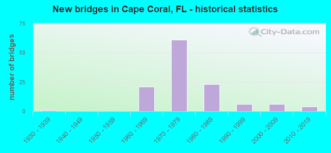
- New bridges - historical statistics
- 11930-1939
- 211960-1969
- 611970-1979
- 231980-1989
- 61990-1999
- 62000-2009
- 42010-2019

- Reconstructed bridges - Historical Statistics
- 11940-1949
- 01950-1959
- 01960-1969
- 61970-1979
- 01980-1989
- 11990-1999
- 12000-2009


- Bridge Condition - Deck
- 4.6%Very good
- 74.1%Good
- 5.6%Satisfactory
- 12.0%Fair
- 3.7%Poor

- Bridge Condition - Superstructure
- 4.6%Very good
- 73.1%Good
- 6.5%Satisfactory
- 12.0%Fair
- 3.7%Poor

- Bridge Condition - Substructure
- 2.8%Very good
- 90.7%Good
- 6.5%Satisfactory

- Bridge Condition - Channel
- 1.7%Excellent
- 7.6%Very good
- 89.9%Good
- 0.8%Satisfactory

- Bridge Condition - Culverts
- 92.3%Good
- 7.7%Satisfactory
Find on map >> Show street view
Structure Number: 125743, Location: .5MI S OF ELDORADO PKWY (Lat: 26.545678, Lng: -81.989528), Route carried "on" structure: City street , Year Built: 1984, Status: Open, Structure Length: 2.87m (9.42ft), Average Daily Traffic: 1,100 (year 2021), Truck Traffic: 2%, Average Future Daily Traffic: 1,155 (year 2041), Design Load: HS 20, Features Intersected: CELLINI CANAL, Facility Carried by Structure: ROSE GARDEN (WB)
Minimum Vertical Clearance: 30+ m (98+ ft), Kilometerpoint: 1.653, Lanes on structure: 1, Owner: City or Municipal Highway Agency, Approaching Roadway Width: 6.1m (20.0ft), Material/Design: Prestressed concrete, Design/Construction: Slab, Number Of Spans In Main Unit: 3, Length of Maximum Span: 9.5m (31.2ft), Curb or Sidewalk Widths: Left: 1.2m (3.9ft), Right: 0.0m, Curb-To-Curb Width: 7.2m (23.6ft), Out-to-Out Width: 9.4m (30.8ft)
Condition: Deck: Good, Superstructure: Good, Substructure: Good, Channel: Good, Operating Rating: 88.4 metric tons, Method Used To Determine Operating Rating: Load Factor (LF), Inventory Rating: 53.1 metric tons, Method Used To Determine Inventory Rating: Load Factor (LF), Structural Evaluation: Better than present minimum criteria, Deck Geometry: High priority of corrective action, Waterway Adequacy: Equal to present desirable criteria, Approach Roadway Alignment: Equal to present desirable criteria, Designated Inspection Frequency: Every 24 months, Inspection Date: November 2021, Deck Structure Type: Concrete Precast Panels, Wearing Surface/Protective System: Wearing Surface: Bituminous
Find on map >> Show street view
Structure Number: 125744, Location: 0.5MI S OF ELDORADO PKWY (Lat: 26.545556, Lng: -81.989583), Route carried "on" structure: City street , Year Built: 1984, Status: Open, Structure Length: 2.87m (9.42ft), Average Daily Traffic: 1,100 (year 2021), Truck Traffic: 2%, Average Future Daily Traffic: 1,155 (year 2041), Design Load: HS 20, Features Intersected: CELLINI CANAL, Facility Carried by Structure: ROSE GARDEN (EB)
Minimum Vertical Clearance: 30+ m (98+ ft), Kilometerpoint: 1.653, Lanes on structure: 1, Owner: City or Municipal Highway Agency, Approaching Roadway Width: 6.1m (20.0ft), Material/Design: Prestressed concrete, Design/Construction: Slab, Number Of Spans In Main Unit: 3, Length of Maximum Span: 9.5m (31.2ft), Curb-To-Curb Width: 8.4m (27.6ft), Out-to-Out Width: 9.4m (30.8ft)
Condition: Deck: Good, Superstructure: Good, Substructure: Good, Channel: Good, Inventory Rating: 54.7 metric tons, Method Used To Determine Inventory Rating: Load Factor (LF), Structural Evaluation: Better than present minimum criteria, Deck Geometry: Meets minimum limits, Waterway Adequacy: Equal to present desirable criteria, Approach Roadway Alignment: Equal to present desirable criteria, Designated Inspection Frequency: Every 24 months, Inspection Date: November 2021, Deck Structure Type: Concrete Precast Panels, Wearing Surface/Protective System: Wearing Surface: Bituminous
Find on map >> Show street view
Structure Number: 125745, Location: BETWEEN US-41 & BROADWAY (Lat: 26.604269, Lng: -81.871981), Route carried "on" structure: City street , Year Built: 2000, Status: Open, Structure Length: 0.63m (2.07ft), Average Daily Traffic: 16,100 (year 2021), Truck Traffic: 10%, Average Future Daily Traffic: 16,905 (year 2041), Design Load: HS 20+Mod, Features Intersected: 10 MILE DRAIN, Facility Carried by Structure: WINKLER AVE
Minimum Vertical Clearance: 30+ m (98+ ft), Kilometerpoint: 0.000, Lanes on structure: 5, Owner: City or Municipal Highway Agency, Approaching Roadway Width: 20.4m (66.9ft), Skew: 20 degrees, Material/Design: Concrete, Design/Construction: Culvert, Number Of Spans In Main Unit: 2, Length of Maximum Span: 3.3m (10.8ft)
Condition: Channel: Good, Culverts: Good, Inventory Rating: 80.7 metric tons, Method Used To Determine Inventory Rating: Load Factor (LF), Structural Evaluation: Better than present minimum criteria, Waterway Adequacy: Better than present minimum criteria, Approach Roadway Alignment: Equal to present desirable criteria, Designated Inspection Frequency: Every 24 months, Inspection Date: October 2021
Find on map >> Show street view
Structure Number: 124098, Location: 4.7MI W OF US-41/SR-45 (Lat: 26.607408, Lng: -81.941219), Route carried "under" structure: Alternate County highway 867, Year Built: 1997, Structure Length: 0. m, Average Daily Traffic: 57,600 (year 2021), Truck Traffic: 5%, Features Intersected: CR-867A/DEL PRADO BLVD, Facility Carried by Structure: CR884/VETERANS PKY
Minimum Vertical Clearance: 5.21m (17.09ft), Kilometerpoint: 4.974, Lanes on structure: 4, Lanes under structure: 6, Material/Design: Steel continuous, Design/Construction: Box Beam or Girders - Multiple, Length of Maximum Span: 67.7m (222.1ft)