Bridge Statistics for Carlsbad, California (CA)
Condition, Traffic, Stress, Structural Evaluation, Project Costs
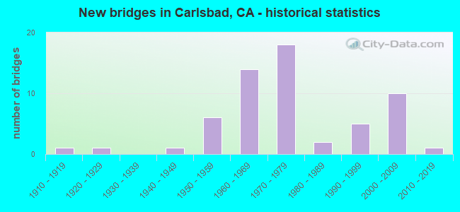
- New bridges - historical statistics
- 11910-1919
- 11920-1929
- 11940-1949
- 61950-1959
- 141960-1969
- 181970-1979
- 21980-1989
- 51990-1999
- 102000-2009
- 12010-2019
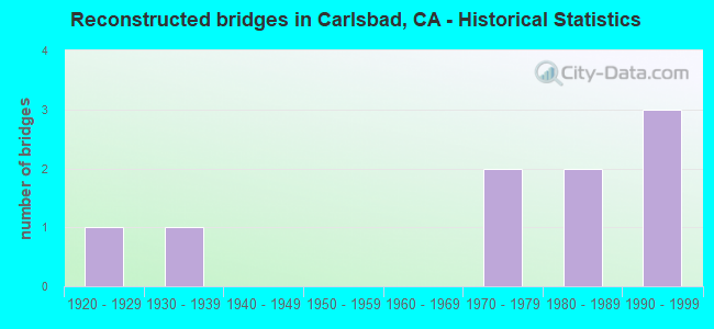
- Reconstructed bridges - Historical Statistics
- 11920-1929
- 11930-1939
- 01940-1949
- 01950-1959
- 01960-1969
- 21970-1979
- 21980-1989
- 31990-1999
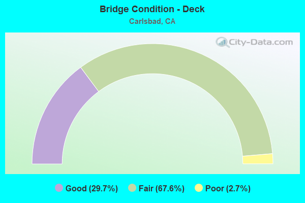
- Bridge Condition - Deck
- 29.7%Good
- 67.6%Fair
- 2.7%Poor
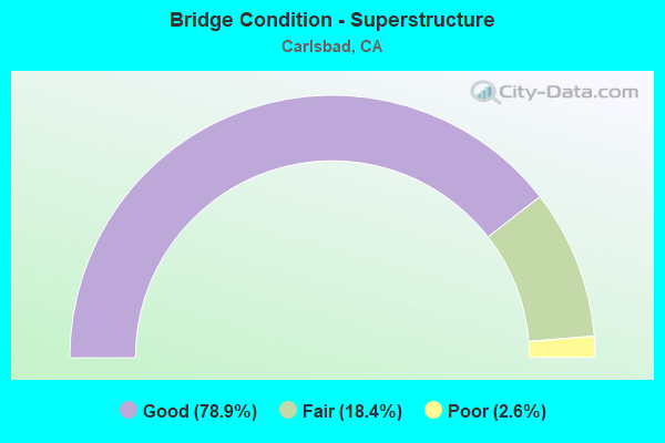
- Bridge Condition - Superstructure
- 78.9%Good
- 18.4%Fair
- 2.6%Poor
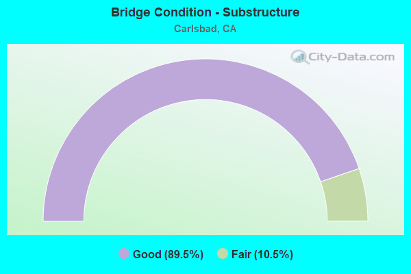
- Bridge Condition - Substructure
- 89.5%Good
- 10.5%Fair
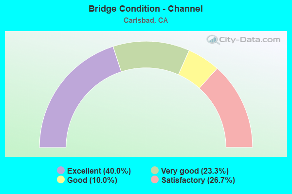
- Bridge Condition - Channel
- 40.0%Excellent
- 23.3%Very good
- 10.0%Good
- 26.7%Satisfactory
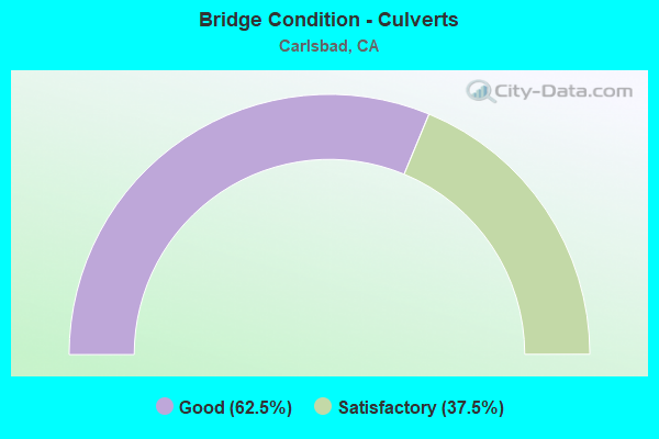
- Bridge Condition - Culverts
- 62.5%Good
- 37.5%Satisfactory
Find on map >> Show street view
Structure Number: 57C0765, Location: 275 FT W/O EL CAMINO REAL (Lat: 33.072894, Lng: -117.264139), Route carried "on" structure: City street , Year Built: 2000, Status: Open, Structure Length: 3.40m (11.15ft), Average Daily Traffic: 12,616 (year 2016), Truck Traffic: 2%, Average Future Daily Traffic: 13,500 (year 2038), Design Load: HS 20+Mod, Features Intersected: ENCINITAS CREEK, Facility Carried by Structure: CALLE BARCELONA
Minimum Vertical Clearance: 30+ m (98+ ft), Kilometerpoint: 0.000, Lanes on structure: 4, Owner: City or Municipal Highway Agency, Approaching Roadway Width: 21.0m (68.9ft), Material/Design: Concrete continuous, Design/Construction: Slab, Number Of Spans In Main Unit: 3, Length of Maximum Span: 13.4m (44.0ft), Curb or Sidewalk Widths: Left: 1.7m (5.6ft), Right: 1.7m (5.6ft), Curb-To-Curb Width: 21.0m (68.9ft), Out-to-Out Width: 24.9m (81.7ft)
Condition: Deck: Fair, Superstructure: Fair, Substructure: Good, Channel: Excellent, Operating Rating: 54.1 metric tons, Method Used To Determine Operating Rating: Assigned rating based on Load Factor Design (LFD) reported in metric tons, Inventory Rating: 32.4 metric tons, Method Used To Determine Inventory Rating: Assigned rating based on Load Factor Design (LFD) reported in metric tons, Structural Evaluation: Somewhat better than minimum adequacy, Deck Geometry: Superior to present desirable criteria, Waterway Adequacy: Equal to present desirable criteria, Approach Roadway Alignment: Equal to present desirable criteria, Designated Inspection Frequency: Every 24 months, Inspection Date: August 2021, Deck Structure Type: Concrete Cast-file-Place
Find on map >> Show street view
Structure Number: 57C0767, Location: 0.1 M E/O CARLSBAD BLVD (Lat: 33.092358, Lng: -117.311892), Route carried "on" structure: City street , Year Built: 1997, Status: Open, Structure Length: 4.42m (14.50ft), Average Daily Traffic: 3,429 (year 2017), Truck Traffic: 1%, Average Future Daily Traffic: 6,609 (year 2039), Design Load: HS 20+Mod, Features Intersected: NCTD, BNSF RY, & AMTRAK, Facility Carried by Structure: AVENIDA ENCINAS
Minimum Vertical Clearance: 30+ m (98+ ft), Kilometerpoint: 0.000, Lanes on structure: 2, Owner: City or Municipal Highway Agency, Approaching Roadway Width: 17.0m (55.8ft), Skew: 1 degrees, Material/Design: Concrete continuous, Design/Construction: Box Beam or Girders - Multiple, Number Of Spans In Main Unit: 3, Length of Maximum Span: 20.7m (67.9ft), Curb or Sidewalk Widths: Left: 1.7m (5.6ft), Right: 1.7m (5.6ft), Curb-To-Curb Width: 17.0m (55.8ft), Out-to-Out Width: 21.0m (68.9ft)
Condition: Deck: Fair, Superstructure: Good, Substructure: Good, Operating Rating: 54.1 metric tons, Method Used To Determine Operating Rating: Assigned rating based on Load Factor Design (LFD) reported in metric tons, Inventory Rating: 32.4 metric tons, Method Used To Determine Inventory Rating: Assigned rating based on Load Factor Design (LFD) reported in metric tons, Structural Evaluation: Better than present minimum criteria, Deck Geometry: Superior to present desirable criteria, Underclear: Equal to present minimum criteria, Approach Roadway Alignment: Equal to present desirable criteria, Designated Inspection Frequency: Every 24 months, Inspection Date: August 2021, Deck Structure Type: Concrete Cast-file-Place
Find on map >> Show street view
Structure Number: 57C0768L, Location: 0.2 M S/O MELROSE DR (Lat: 33.103386, Lng: -117.223933), Route carried "on" structure: City street , Year Built: 2004, Status: Open, Structure Length: 11.22m (36.81ft), Average Daily Traffic: 14,738 (year 2017), Truck Traffic: 3%, Average Future Daily Traffic: 16,245 (year 2039), Design Load: HS 20+Mod, Features Intersected: SAN MARCOS CREEK, Facility Carried by Structure: RANCHO SANTA FE SB
Minimum Vertical Clearance: 30+ m (98+ ft), Kilometerpoint: 0.000, Lanes on structure: 3, Base Highway Network: Yes, Owner: City or Municipal Highway Agency, Approaching Roadway Width: 13.2m (43.3ft), Skew: 5 degrees, Material/Design: Concrete continuous, Design/Construction: Box Beam or Girders - Multiple, Number Of Spans In Main Unit: 3, Length of Maximum Span: 38.4m (126.0ft), Curb or Sidewalk Widths: Left: 1.4m (4.6ft), Right: 0.0m, Curb-To-Curb Width: 13.2m (43.3ft), Out-to-Out Width: 15.8m (51.8ft)
Condition: Deck: Fair, Superstructure: Good, Substructure: Good, Channel: Very good, Operating Rating: 54.1 metric tons, Method Used To Determine Operating Rating: Assigned rating based on Load Factor Design (LFD) reported in metric tons, Inventory Rating: 32.4 metric tons, Method Used To Determine Inventory Rating: Assigned rating based on Load Factor Design (LFD) reported in metric tons, Structural Evaluation: Better than present minimum criteria, Deck Geometry: Somewhat better than minimum adequacy, Waterway Adequacy: Equal to present desirable criteria, Approach Roadway Alignment: Equal to present desirable criteria, Designated Inspection Frequency: Every 24 months, Inspection Date: August 2021, Deck Structure Type: Concrete Cast-file-Place
Find on map >> Show street view
Structure Number: 57C0768R, Location: 0.2 M S/O MELROSE DR (Lat: 33.103317, Lng: -117.223583), Route carried "on" structure: City street , Year Built: 2004, Status: Open, Structure Length: 11.22m (36.81ft), Average Daily Traffic: 14,101 (year 2017), Truck Traffic: 3%, Average Future Daily Traffic: 16,245 (year 2039), Design Load: HS 20+Mod, Features Intersected: SAN MARCOS CREEK, Facility Carried by Structure: RANCHO SANTA FE NB
Minimum Vertical Clearance: 30+ m (98+ ft), Kilometerpoint: 0.000, Lanes on structure: 3, Base Highway Network: Yes, Owner: City or Municipal Highway Agency, Approaching Roadway Width: 13.2m (43.3ft), Skew: 5 degrees, Material/Design: Concrete continuous, Design/Construction: Box Beam or Girders - Multiple, Number Of Spans In Main Unit: 3, Length of Maximum Span: 38.4m (126.0ft), Curb or Sidewalk Widths: Left: 0.0m, Right: 1.4m (4.6ft), Curb-To-Curb Width: 13.2m (43.3ft), Out-to-Out Width: 15.8m (51.8ft)
Condition: Deck: Fair, Superstructure: Good, Substructure: Good, Channel: Excellent, Operating Rating: 54.1 metric tons, Method Used To Determine Operating Rating: Assigned rating based on Load Factor Design (LFD) reported in metric tons, Inventory Rating: 32.4 metric tons, Method Used To Determine Inventory Rating: Assigned rating based on Load Factor Design (LFD) reported in metric tons, Structural Evaluation: Better than present minimum criteria, Deck Geometry: Somewhat better than minimum adequacy, Waterway Adequacy: Equal to present desirable criteria, Approach Roadway Alignment: Equal to present desirable criteria, Designated Inspection Frequency: Every 24 months, Inspection Date: August 2021, Deck Structure Type: Concrete Cast-file-Place
Find on map >> Show street view
Structure Number: 57C0769, Location: 0.22 MI S/O OLIVENHAIN RD (Lat: 33.065728, Lng: -117.244594), Route carried "on" structure: City street , Year Built: 2004, Status: Open, Structure Length: 0.98m (3.22ft), Average Daily Traffic: 16,929 (year 2016), Truck Traffic: 1%, Average Future Daily Traffic: 17,500 (year 2038), Features Intersected: ENCINITAS CREEK, Facility Carried by Structure: RANCHO SANTA FE RD
Minimum Vertical Clearance: 30+ m (98+ ft), Kilometerpoint: 0.000, Lanes on structure: 4, Owner: City or Municipal Highway Agency, Approaching Roadway Width: 21.8m (71.5ft), Skew: 30 degrees, Material/Design: Concrete continuous, Design/Construction: Culvert, Number Of Spans In Main Unit: 3, Length of Maximum Span: 3.2m (10.5ft)
Condition: Channel: Excellent, Culverts: Good, Operating Rating: 54.1 metric tons, Method Used To Determine Operating Rating: Field evaluation and documented engineering judgment, Inventory Rating: 32.4 metric tons, Method Used To Determine Inventory Rating: Field evaluation and documented engineering judgment, Structural Evaluation: Better than present minimum criteria, Waterway Adequacy: Equal to present desirable criteria, Approach Roadway Alignment: Equal to present desirable criteria, Designated Inspection Frequency: Every 48 months, Inspection Date: July 2019
Find on map >> Show street view
Structure Number: 57C0790L, Location: 0.6 MI S/O PALOMAR ARPRT (Lat: 33.115808, Lng: -117.324983), Route carried "on" structure: City street , Year Built: 2010, Status: Open, Structure Length: 1.17m (3.84ft), Average Daily Traffic: 11,000 (year 2017), Truck Traffic: 1%, Average Future Daily Traffic: 16,269 (year 2039), Design Load: HS 20+Mod, Features Intersected: LAS ENCINAS CREEK, Facility Carried by Structure: CARLSBAD BLVD SB
Minimum Vertical Clearance: 30+ m (98+ ft), Kilometerpoint: 0.000, Lanes on structure: 2, Owner: City or Municipal Highway Agency, Approaching Roadway Width: 12.0m (39.4ft), Material/Design: Concrete, Design/Construction: Culvert, Number Of Spans In Main Unit: 10, Length of Maximum Span: 11.0m (36.1ft), Curb or Sidewalk Widths: Left: 0.0m, Right: 1.5m (4.9ft), Curb-To-Curb Width: 10.7m (35.1ft), Out-to-Out Width: 12.2m (40.0ft)
Condition: Channel: Excellent, Culverts: Good, Operating Rating: 54.1 metric tons, Method Used To Determine Operating Rating: Assigned rating based on Load Factor Design (LFD) reported in metric tons, Inventory Rating: 32.4 metric tons, Method Used To Determine Inventory Rating: Assigned rating based on Load Factor Design (LFD) reported in metric tons, Structural Evaluation: Better than present minimum criteria, Deck Geometry: Somewhat better than minimum adequacy, Waterway Adequacy: Equal to present desirable criteria, Approach Roadway Alignment: Equal to present desirable criteria, Designated Inspection Frequency: Every 48 months, Inspection Date: August 2021
Find on map >> Show street view
Structure Number: 57 0249, Location: 11-SD-005-R47.98-CBD (Lat: 33.134514, Lng: -117.329106), Route carried "under" structure: City street S0349, Year Built: 1971, Structure Length: 0. m, Average Daily Traffic: 6,050 (year 2020), Truck Traffic: 2%, Features Intersected: CANNON ROAD, Facility Carried by Structure: INTERSTATE 5
Minimum Vertical Clearance: 4.60m (15.09ft), Kilometerpoint: 0.000, Lanes on structure: 8, Lanes under structure: 6, Material/Design: Prestressed concrete, Design/Construction: Box Beam or Girders - Multiple, Length of Maximum Span: 35.4m (116.1ft)
Find on map >> Show street view
Structure Number: 57 0271, Location: 11-SD-005-R50.86-CBD (Lat: 33.172336, Lng: -117.348483), Route carried "under" structure: Interstate 5, Year Built: 1970, Structure Length: 0. m, Average Daily Traffic: 203,000 (year 2020), Truck Traffic: 6%, Features Intersected: ROUTE 5, Facility Carried by Structure: JEFFERSON ST
Minimum Vertical Clearance: 5.69m (18.67ft), Kilometerpoint: 50.860, Lanes on structure: 2, Lanes under structure: 10, Material/Design: Concrete continuous, Design/Construction: Box Beam or Girders - Multiple, Length of Maximum Span: 38.4m (126.0ft)
Find on map >> Show street view
Structure Number: 57 0272, Location: 11-SD-005-R50.68-CBD (Lat: 33.170611, Lng: -117.346881), Route carried "under" structure: Interstate 5, Year Built: 1971, Structure Length: 0. m, Average Daily Traffic: 203,000 (year 2020), Truck Traffic: 6%, Features Intersected: ROUTE 5, Facility Carried by Structure: LAS FLORES DR
Minimum Vertical Clearance: 5.41m (17.75ft), Kilometerpoint: 50.680, Lanes on structure: 2, Lanes under structure: 8, Material/Design: Prestressed concrete continuous, Design/Construction: Box Beam or Girders - Multiple, Length of Maximum Span: 39.3m (128.9ft)
Find on map >> Show street view
Structure Number: 57 0274, Location: 11-SD-005-R50.11-CBD (Lat: 33.163253, Lng: -117.341978), Route carried "under" structure: City street S352, Year Built: 1971, Structure Length: 0. m, Average Daily Traffic: 17,800 (year 2020), Truck Traffic: 2%, Features Intersected: CARLSBAD VILLAGE DR, Facility Carried by Structure: INTERSTATE 5
Minimum Vertical Clearance: 4.55m (14.93ft), Kilometerpoint: 0.000, Lanes on structure: 8, Lanes under structure: 5, Material/Design: Prestressed concrete, Design/Construction: Box Beam or Girders - Multiple, Length of Maximum Span: 37.5m (123.0ft)
Find on map >> Show street view
Structure Number: 57 0275, Location: 11-SD-005-R49.73-CBD (Lat: 33.158169, Lng: -117.339400), Route carried "under" structure: City street S0351, Year Built: 1971, Structure Length: 0. m, Average Daily Traffic: 5,470 (year 2020), Truck Traffic: 2%, Features Intersected: CHESTNUT AVE, Facility Carried by Structure: INTERSTATE 5
Minimum Vertical Clearance: 4.67m (15.32ft), Kilometerpoint: 0.000, Lanes on structure: 8, Lanes under structure: 2, Material/Design: Prestressed concrete, Design/Construction: Box Beam or Girders - Multiple, Length of Maximum Span: 35.1m (115.2ft)
Find on map >> Show street view
Structure Number: 57 0276, Location: 11-SD-005-R49.28-CBD (Lat: 33.151919, Lng: -117.336694), Route carried "under" structure: Interstate 5, Year Built: 1971, Structure Length: 0. m, Average Daily Traffic: 203,000 (year 2020), Truck Traffic: 6%, Features Intersected: INTERSTATE 5, Facility Carried by Structure: TAMARACK AVENUE
Minimum Vertical Clearance: 5.36m (17.59ft), Kilometerpoint: 49.280, Lanes on structure: 5, Lanes under structure: 8, Material/Design: Prestressed concrete continuous, Design/Construction: Box Beam or Girders - Multiple, Length of Maximum Span: 35.4m (116.1ft)
Find on map >> Show street view
Structure Number: 57 046, Location: 11-SD-005-R44.07-CBD (Lat: 33.084033, Lng: -117.298458), Route carried "under" structure: Interstate 5, Year Built: 1965, Structure Length: 0. m, Average Daily Traffic: 222,000 (year 2020), Truck Traffic: 6%, Features Intersected: INTERSTATE 5, Facility Carried by Structure: LA COSTA AVE
Minimum Vertical Clearance: 5.31m (17.42ft), Kilometerpoint: 44.070, Lanes on structure: 6, Lanes under structure: 8, Material/Design: Concrete continuous, Design/Construction: Box Beam or Girders - Multiple, Length of Maximum Span: 34.1m (111.9ft)
Find on map >> Show street view
Structure Number: 57 0555, Location: 11-SD-005-R45.57-CBD (Lat: 33.103231, Lng: -117.310831), Route carried "under" structure: Interstate 5, Year Built: 1965, Structure Length: 0. m, Average Daily Traffic: 222,000 (year 2020), Truck Traffic: 6%, Features Intersected: INTERSTATE 5, Facility Carried by Structure: POINSETTIA LANE
Minimum Vertical Clearance: 5.03m (16.50ft), Kilometerpoint: 45.570, Lanes on structure: 6, Lanes under structure: 8, Material/Design: Concrete continuous, Design/Construction: Box Beam or Girders - Multiple, Length of Maximum Span: 32.3m (106.0ft)
Find on map >> Show street view
Structure Number: 57 0556, Location: 11-SD-005-R47.03-CBD (Lat: 33.121975, Lng: -117.322442), Route carried "under" structure: Interstate 5, Year Built: 1966, Structure Length: 0. m, Average Daily Traffic: 222,000 (year 2020), Truck Traffic: 7%, Features Intersected: INTERSTATE 5, Facility Carried by Structure: PALOMAR AIRPORT RD
Minimum Vertical Clearance: 5.00m (16.40ft), Kilometerpoint: 47.030, Lanes on structure: 7, Lanes under structure: 9, Material/Design: Prestressed concrete continuous, Design/Construction: Box Beam or Girders - Multiple, Length of Maximum Span: 43.6m (143.0ft)
Find on map >> Show street view
Structure Number: 57 0672, Location: 11-SD-005-R49.12-CBD (Lat: 33.149936, Lng: -117.335597), Route carried "under" structure: Interstate 5, Year Built: 1970, Structure Length: 0. m, Average Daily Traffic: 222,000 (year 2020), Truck Traffic: 6%, Features Intersected: INTERSTATE 5, Facility Carried by Structure: CHINQUAPIN AVE
Minimum Vertical Clearance: 5.21m (17.09ft), Kilometerpoint: 49.120, Lanes on structure: 2, Lanes under structure: 10, Material/Design: Prestressed concrete continuous, Design/Construction: Box Beam or Girders - Multiple, Length of Maximum Span: 48.8m (160.1ft)
Find on map >> Show street view
Structure Number: 57C0215, Location: 0.35MI W/O ROUTE 5 (Lat: 33.123500, Lng: -117.327675), Route carried "under" structure: City street , Year Built: 1953, Structure Length: 0. m, Average Daily Traffic: 7,269 (year 2017), Truck Traffic: 1%, Features Intersected: CARLSBAD BLVD, Facility Carried by Structure: PALOMAR AIRPORT RD
Minimum Vertical Clearance: 6.05m (19.85ft), Kilometerpoint: 0.000, Lanes on structure: 2, Lanes under structure: 2, Material/Design: Concrete continuous, Design/Construction: Box Beam or Girders - Multiple, Length of Maximum Span: 28.7m (94.2ft)
Find on map >> Show street view
Structure Number: 57C0758, Location: 460FT N/O PALOMAR AIRPORT (Lat: 33.125489, Lng: -117.301478), Route carried "under" structure: City street , Year Built: 2005, Structure Length: 0. m, Average Daily Traffic: 11,000 (year 2017), Truck Traffic: 1%, Features Intersected: COLLEGE BLVD, Facility Carried by Structure: GOLF CART/PED WALK
Minimum Vertical Clearance: 5.59m (18.34ft), Kilometerpoint: 0.000, Lanes under structure: 4, Material/Design: Prestressed concrete, Design/Construction: Box Beam or Girders - Single/Spread, Length of Maximum Span: 37.5m (123.0ft)
Find on map >> Show street view
Structure Number: 57C0766, Location: 0.5 M E/O EL CAMINO REAL (Lat: 33.075564, Lng: -117.254478), Route carried "under" structure: City street , Year Built: 1999, Structure Length: 0. m, Average Daily Traffic: 10,489 (year 2017), Truck Traffic: 2%, Features Intersected: CALLE BARCELONA, Facility Carried by Structure: PEDESTRIAN WALKWAY
Minimum Vertical Clearance: 5.19m (17.03ft), Kilometerpoint: 0.000, Lanes under structure: 4, Material/Design: Concrete, Design/Construction: Stringer/Multi-beam, Length of Maximum Span: 33.5m (109.9ft)