Bridge Statistics for Carneys Point, New Jersey (NJ)
Condition, Traffic, Stress, Structural Evaluation, Project Costs
- National Bridge Inventory (NBI) Statistics
- 50Number of bridges
- 463ft / 141mTotal length
- $29,717,000Total costs
- 1,019,944Total average daily traffic
- 85,269Total average daily truck traffic
- National Bridge Inventory (NBI) Registered Bridges for Carneys Point
- No street view available for this location
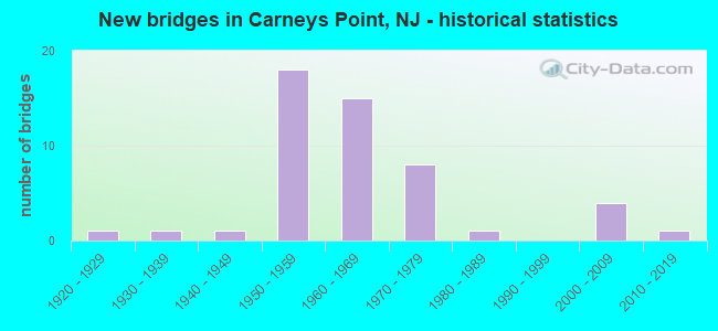
- New bridges - historical statistics
- 11920-1929
- 11930-1939
- 11940-1949
- 181950-1959
- 151960-1969
- 81970-1979
- 11980-1989
- 42000-2009
- 12010-2019

- Reconstructed bridges - Historical Statistics
- 41990-1999
- 22000-2009
- 02010-2019
- 12020-2022


- Bridge Condition - Deck
- 17.2%Very good
- 27.6%Good
- 31.0%Satisfactory
- 17.2%Fair
- 6.9%Poor

- Bridge Condition - Superstructure
- 3.4%Excellent
- 3.4%Very good
- 34.5%Good
- 27.6%Satisfactory
- 27.6%Fair
- 3.4%Poor

- Bridge Condition - Substructure
- 6.9%Very good
- 20.7%Good
- 51.7%Satisfactory
- 17.2%Fair
- 3.4%Poor

- Bridge Condition - Channel
- 6.3%Excellent
- 25.0%Very good
- 25.0%Good
- 43.8%Satisfactory
Find on map >> Show street view
Structure Number: M00489, Location: 3.6 MI NORTH OF EXIT 1 (Lat: 39.694550, Lng: -75.404008), Route carried "under" structure: Other road NJTPK, Year Built: 1950, Structure Length: 0. m, Average Daily Traffic: 51,322 (year 2020), Truck Traffic: 7%, Features Intersected: NJ TURNPIKE, Facility Carried by Structure: PENNSGROVE-AUBURN
Minimum Vertical Clearance: 4.80m (15.75ft), Kilometerpoint: 8.224, Lanes on structure: 2, Lanes under structure: 4, Toll: On toll road, Material/Design: Steel continuous, Design/Construction: Stringer/Multi-beam, Length of Maximum Span: 15.8m (51.8ft)
Find on map >> Show street view
Structure Number: M00573, Location: 4.5 MI NORTH OF EXIT 1 (Lat: 39.698850, Lng: -75.389278), Route carried "under" structure: Other road NJTPK, Year Built: 1950, Structure Length: 0. m, Average Daily Traffic: 52,348 (year 2020), Truck Traffic: 12%, Features Intersected: NJ TURNPIKE, Facility Carried by Structure: STUMPY ROAD
Minimum Vertical Clearance: 4.70m (15.42ft), Kilometerpoint: 9.656, Lanes on structure: 2, Lanes under structure: 4, Toll: On toll road, Material/Design: Steel continuous, Design/Construction: Stringer/Multi-beam, Length of Maximum Span: 17.7m (58.1ft)