Bridge Statistics for Carrollton, Texas (TX)
Condition, Traffic, Stress, Structural Evaluation, Project Costs
- National Bridge Inventory (NBI) Statistics
- 221Number of bridges
- 9,108ft / 2,776mTotal length
- $757,000Total costs
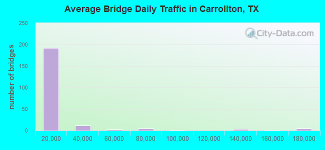
- 3,696,418Total average daily traffic
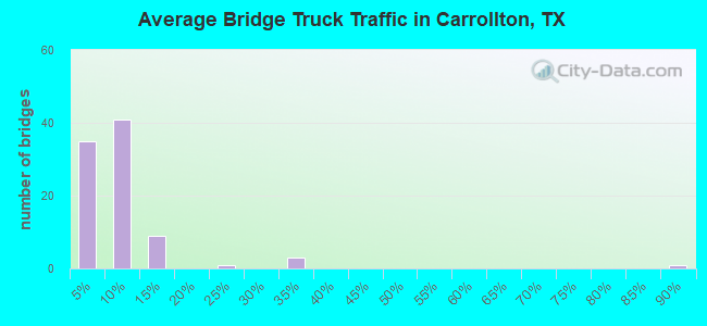
- 196,233Total average daily truck traffic
- National Bridge Inventory (NBI) Registered Bridges for Carrollton
- No street view available for this location
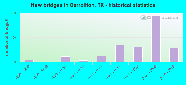
- New bridges - historical statistics
- 41930-1939
- 111950-1959
- 31960-1969
- 131970-1979
- 351980-1989
- 311990-1999
- 952000-2009
- 292010-2019
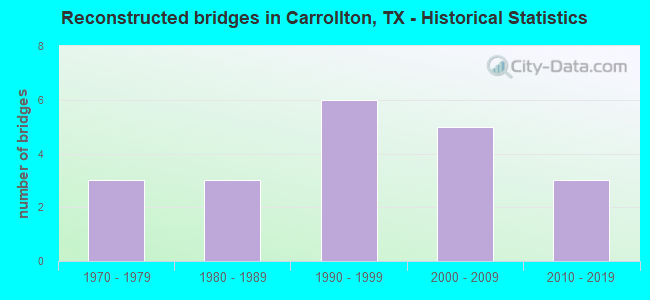
- Reconstructed bridges - Historical Statistics
- 31970-1979
- 31980-1989
- 61990-1999
- 52000-2009
- 32010-2019
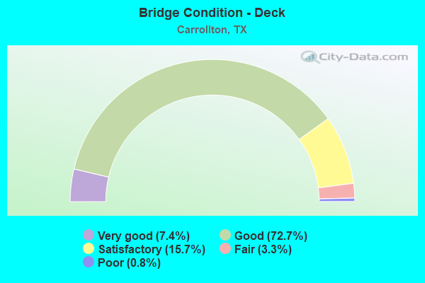
- Bridge Condition - Deck
- 7.4%Very good
- 72.7%Good
- 15.7%Satisfactory
- 3.3%Fair
- 0.8%Poor
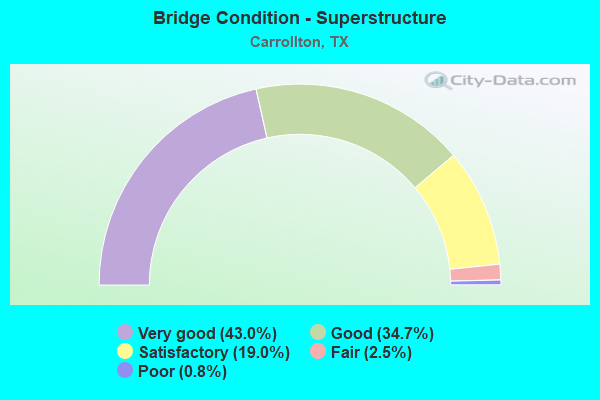
- Bridge Condition - Superstructure
- 43.0%Very good
- 34.7%Good
- 19.0%Satisfactory
- 2.5%Fair
- 0.8%Poor
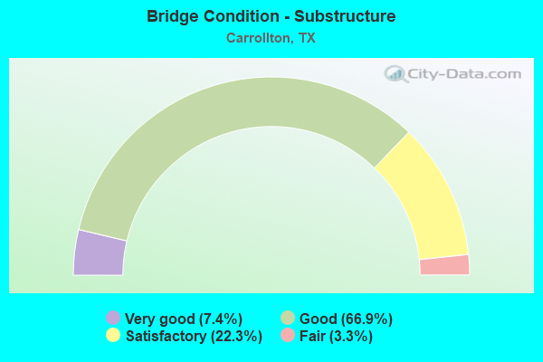
- Bridge Condition - Substructure
- 7.4%Very good
- 66.9%Good
- 22.3%Satisfactory
- 3.3%Fair
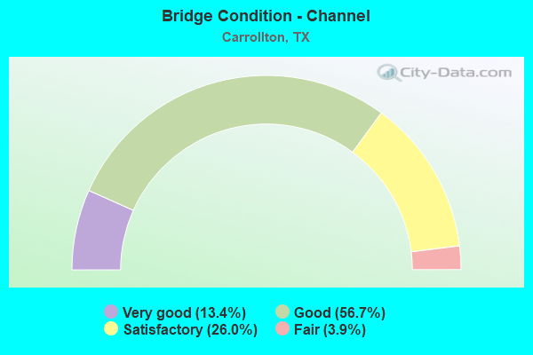
- Bridge Condition - Channel
- 13.4%Very good
- 56.7%Good
- 26.0%Satisfactory
- 3.9%Fair
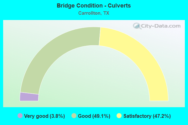
- Bridge Condition - Culverts
- 3.8%Very good
- 49.1%Good
- 47.2%Satisfactory
Find on map >> Show street view
Structure Number: 180570296402588, Location: 3.0 Mi N of IH 635 (Lat: 32.945900, Lng: -96.928169), Route carried "on" structure: Other road 190, Year Built: 2006, Status: Open, Structure Length: 127.92m (419.69ft), Average Daily Traffic: 10,000 (year 2011), Average Future Daily Traffic: 12,000 (year 2031), Design Load: HS 20, Features Intersected: Belt Line Rd & Hutton Br, Facility Carried by Structure: PGBT SB
Minimum Vertical Clearance: 30+ m (98+ ft), Kilometerpoint: 85.670, Lanes on structure: 3, Lanes under structure: 9, Toll: On toll road, Owner: Local Toll Authority, Approaching Roadway Width: 20.7m (67.9ft), Skew: 9 degrees, Material/Design: Prestressed concrete, Design/Construction: Stringer/Multi-beam, Number Of Spans In Main Unit: 35, Length of Maximum Span: 38.7m (127.0ft), Curb-To-Curb Width: 20.5m (67.3ft), Out-to-Out Width: 21.3m (69.9ft)
Condition: Deck: Good, Superstructure: Good, Substructure: Good, Channel: Good, Operating Rating: 54.4 metric tons, Method Used To Determine Operating Rating: Assigned rating based on Load Factor Design (LFD) reported in metric tons, Inventory Rating: 32.7 metric tons, Method Used To Determine Inventory Rating: Assigned rating based on Load Factor Design (LFD) reported in metric tons, Structural Evaluation: Better than present minimum criteria, Deck Geometry: Superior to present desirable criteria, Underclear: High priority of corrective action, Waterway Adequacy: Superior to present desirable criteria, Approach Roadway Alignment: Equal to present desirable criteria, Designated Inspection Frequency: Every 24 months, Inspection Date: June 2020, Deck Structure Type: Concrete Precast Panels
Find on map >> Show street view
Structure Number: 180570296402589, Location: 3.0 Mi N of IH 635 (Lat: 32.945900, Lng: -96.927819), Route carried "on" structure: Other road 190, Year Built: 2006, Status: Open, Structure Length: 127.92m (419.69ft), Average Daily Traffic: 10,000 (year 2011), Average Future Daily Traffic: 12,000 (year 2031), Design Load: HS 20, Features Intersected: Belt Line Rd & Hutton Br, Facility Carried by Structure: PGBT NB
Minimum Vertical Clearance: 30+ m (98+ ft), Kilometerpoint: 85.670, Lanes on structure: 3, Lanes under structure: 9, Toll: On toll road, Owner: Local Toll Authority, Approaching Roadway Width: 17.5m (57.4ft), Skew: 9 degrees, Material/Design: Prestressed concrete, Design/Construction: Stringer/Multi-beam, Number Of Spans In Main Unit: 35, Length of Maximum Span: 39.3m (128.9ft), Curb-To-Curb Width: 17.5m (57.4ft), Out-to-Out Width: 21.3m (69.9ft)
Condition: Deck: Good, Superstructure: Good, Substructure: Good, Channel: Good, Operating Rating: 54.4 metric tons, Method Used To Determine Operating Rating: Assigned rating based on Load Factor Design (LFD) reported in metric tons, Inventory Rating: 32.7 metric tons, Method Used To Determine Inventory Rating: Assigned rating based on Load Factor Design (LFD) reported in metric tons, Structural Evaluation: Better than present minimum criteria, Deck Geometry: Better than present minimum criteria, Underclear: High priority of corrective action, Waterway Adequacy: Superior to present desirable criteria, Approach Roadway Alignment: Equal to present desirable criteria, Designated Inspection Frequency: Every 24 months, Inspection Date: June 2020, Deck Structure Type: Concrete Precast Panels
Find on map >> Show street view
Structure Number: 18057029640259, Location: 3.2 Mi N of IH 635 (Lat: 32.954819, Lng: -96.925550), Route carried "on" structure: Ramp Other road 190, Year Built: 2006, Status: Open, Structure Length: 29.75m (97.60ft), Average Daily Traffic: 10,000 (year 2011), Average Future Daily Traffic: 12,000 (year 2031), Design Load: HS 20, Features Intersected: Tributary of Elm Fork, Facility Carried by Structure: PGBT SB Off-Ramp
Minimum Vertical Clearance: 5.18m (16.99ft), Kilometerpoint: 90.878, Lanes on structure: 1, Toll: On toll road, Owner: Local Toll Authority, Approaching Roadway Width: 8.4m (27.6ft), Material/Design: Prestressed concrete, Design/Construction: Stringer/Multi-beam, Number Of Spans In Main Unit: 14, Length of Maximum Span: 22.6m (74.1ft), Curb-To-Curb Width: 8.3m (27.2ft), Out-to-Out Width: 9.1m (29.9ft)
Condition: Deck: Good, Superstructure: Good, Substructure: Good, Channel: Very good, Operating Rating: 54.4 metric tons, Method Used To Determine Operating Rating: Assigned rating based on Load Factor Design (LFD) reported in metric tons, Inventory Rating: 32.7 metric tons, Method Used To Determine Inventory Rating: Assigned rating based on Load Factor Design (LFD) reported in metric tons, Structural Evaluation: Better than present minimum criteria, Deck Geometry: Better than present minimum criteria, Waterway Adequacy: Superior to present desirable criteria, Approach Roadway Alignment: Equal to present desirable criteria, Designated Inspection Frequency: Every 24 months, Inspection Date: June 2020, Deck Structure Type: Concrete Precast Panels
Find on map >> Show street view
Structure Number: 180570296402591, Location: 3.3 Mi N of IH 635 (Lat: 32.955194, Lng: -96.925353), Route carried "on" structure: Ramp Other road 190, Year Built: 2006, Status: Open, Structure Length: 23.65m (77.59ft), Average Daily Traffic: 10,000 (year 2011), Average Future Daily Traffic: 12,000 (year 2031), Design Load: HS 20, Features Intersected: Tributary of Elm Fork, Facility Carried by Structure: PGBT NB On-Ramp
Minimum Vertical Clearance: 30+ m (98+ ft), Kilometerpoint: 91.462, Lanes on structure: 1, Toll: On toll road, Owner: Local Toll Authority, Approaching Roadway Width: 7.9m (25.9ft), Material/Design: Prestressed concrete, Design/Construction: Stringer/Multi-beam, Number Of Spans In Main Unit: 10, Length of Maximum Span: 24.4m (80.1ft), Curb-To-Curb Width: 7.7m (25.3ft), Out-to-Out Width: 8.5m (27.9ft)
Condition: Deck: Good, Superstructure: Good, Substructure: Good, Channel: Very good, Operating Rating: 54.4 metric tons, Method Used To Determine Operating Rating: Assigned rating based on Load Factor Design (LFD) reported in metric tons, Inventory Rating: 32.7 metric tons, Method Used To Determine Inventory Rating: Assigned rating based on Load Factor Design (LFD) reported in metric tons, Structural Evaluation: Better than present minimum criteria, Deck Geometry: Better than present minimum criteria, Waterway Adequacy: Superior to present desirable criteria, Approach Roadway Alignment: Equal to present desirable criteria, Designated Inspection Frequency: Every 24 months, Inspection Date: June 2020, Deck Structure Type: Concrete Precast Panels
Find on map >> Show street view
Structure Number: 180570296402592, Location: 1.0 Mi S of IH 35E (Lat: 32.968358, Lng: -96.932625), Route carried "on" structure: Other road 190, Year Built: 2006, Status: Open, Structure Length: 6.98m (22.90ft), Average Daily Traffic: 10,000 (year 2011), Average Future Daily Traffic: 12,000 (year 2031), Design Load: HS 20, Features Intersected: Sandy Lake Rd, Facility Carried by Structure: PGBT NB
Minimum Vertical Clearance: 30+ m (98+ ft), Kilometerpoint: 112.392, Lanes on structure: 3, Lanes under structure: 9, Toll: On toll road, Owner: Local Toll Authority, Approaching Roadway Width: 20.5m (67.3ft), Material/Design: Prestressed concrete, Design/Construction: Stringer/Multi-beam, Number Of Spans In Main Unit: 2, Length of Maximum Span: 38.4m (126.0ft), Curb-To-Curb Width: 20.5m (67.3ft), Out-to-Out Width: 21.3m (69.9ft)
Condition: Deck: Good, Superstructure: Very good, Substructure: Good, Operating Rating: 54.4 metric tons, Method Used To Determine Operating Rating: Assigned rating based on Load Factor Design (LFD) reported in metric tons, Inventory Rating: 32.7 metric tons, Method Used To Determine Inventory Rating: Assigned rating based on Load Factor Design (LFD) reported in metric tons, Structural Evaluation: Better than present minimum criteria, Deck Geometry: Superior to present desirable criteria, Underclear: Meets minimum limits, Approach Roadway Alignment: Equal to present desirable criteria, Designated Inspection Frequency: Every 24 months, Inspection Date: June 2020, Deck Structure Type: Concrete Precast Panels
Find on map >> Show street view
Structure Number: 180570296402593, Location: 1.0 Mi S of IH 35E (Lat: 32.968361, Lng: -96.932944), Route carried "on" structure: Other road 190, Year Built: 2006, Status: Open, Structure Length: 6.98m (22.90ft), Average Daily Traffic: 10,000 (year 2011), Average Future Daily Traffic: 12,000 (year 2031), Design Load: HS 20, Features Intersected: Sandy Lake Rd, Facility Carried by Structure: PGBT SB
Minimum Vertical Clearance: 30+ m (98+ ft), Kilometerpoint: 112.392, Lanes on structure: 3, Lanes under structure: 9, Toll: On toll road, Owner: Local Toll Authority, Approaching Roadway Width: 20.5m (67.3ft), Material/Design: Prestressed concrete, Design/Construction: Stringer/Multi-beam, Number Of Spans In Main Unit: 2, Length of Maximum Span: 38.4m (126.0ft), Curb-To-Curb Width: 20.5m (67.3ft), Out-to-Out Width: 21.3m (69.9ft)
Condition: Deck: Good, Superstructure: Good, Substructure: Good, Operating Rating: 54.4 metric tons, Method Used To Determine Operating Rating: Assigned rating based on Load Factor Design (LFD) reported in metric tons, Inventory Rating: 32.7 metric tons, Method Used To Determine Inventory Rating: Assigned rating based on Load Factor Design (LFD) reported in metric tons, Structural Evaluation: Better than present minimum criteria, Deck Geometry: Superior to present desirable criteria, Underclear: Meets minimum limits, Approach Roadway Alignment: Equal to present desirable criteria, Designated Inspection Frequency: Every 24 months, Inspection Date: June 2020, Deck Structure Type: Concrete Precast Panels
Find on map >> Show street view
Structure Number: 180570296402594, Location: 0.8 Mi S of IH 35E (Lat: 32.971200, Lng: -96.931928), Route carried "on" structure: Other road 190, Year Built: 2006, Status: Open, Structure Length: 10.85m (35.60ft), Average Daily Traffic: 10,000 (year 2011), Average Future Daily Traffic: 12,000 (year 2031), Design Load: HS 20, Features Intersected: DWU Access Rd, Facility Carried by Structure: PGBT NBFR
Minimum Vertical Clearance: 30+ m (98+ ft), Kilometerpoint: 7.557, Lanes on structure: 2, Lanes under structure: 1, Toll: On toll road, Owner: Local Toll Authority, Approaching Roadway Width: 8.3m (27.2ft), Skew: 9 degrees, Material/Design: Prestressed concrete, Design/Construction: Stringer/Multi-beam, Number Of Spans In Main Unit: 4, Length of Maximum Span: 34.1m (111.9ft), Curb-To-Curb Width: 8.3m (27.2ft), Out-to-Out Width: 9.1m (29.9ft)
Condition: Deck: Good, Superstructure: Very good, Substructure: Good, Operating Rating: 54.4 metric tons, Method Used To Determine Operating Rating: Assigned rating based on Load Factor Design (LFD) reported in metric tons, Inventory Rating: 32.7 metric tons, Method Used To Determine Inventory Rating: Assigned rating based on Load Factor Design (LFD) reported in metric tons, Structural Evaluation: Better than present minimum criteria, Deck Geometry: High priority of replacement, Underclear: Superior to present desirable criteria, Approach Roadway Alignment: Equal to present desirable criteria, Length Of Structure Improvement: 10.85m (35.60ft), Designated Inspection Frequency: Every 24 months, Inspection Date: June 2020, Bridge Improvement Cost: $19,000, Roadway Improvement Cost: $5,000, Total Project Cost: $24,000, Deck Structure Type: Concrete Precast Panels
Find on map >> Show street view
Structure Number: 180570296402595, Location: 0.8 Mi S of IH 35E (Lat: 32.971200, Lng: -96.932044), Route carried "on" structure: Other road 190, Year Built: 2006, Status: Open, Structure Length: 10.85m (35.60ft), Average Daily Traffic: 10,000 (year 2011), Average Future Daily Traffic: 12,000 (year 2031), Design Load: HS 20, Features Intersected: DWU Access Rd, Facility Carried by Structure: PGBT NB On-Ramp
Minimum Vertical Clearance: 30+ m (98+ ft), Kilometerpoint: 7.557, Lanes on structure: 1, Lanes under structure: 1, Toll: On toll road, Owner: Local Toll Authority, Approaching Roadway Width: 7.8m (25.6ft), Skew: 9 degrees, Material/Design: Prestressed concrete, Design/Construction: Stringer/Multi-beam, Number Of Spans In Main Unit: 4, Length of Maximum Span: 34.1m (111.9ft), Curb-To-Curb Width: 7.7m (25.3ft), Out-to-Out Width: 8.5m (27.9ft)
Condition: Deck: Good, Superstructure: Very good, Substructure: Good, Operating Rating: 54.4 metric tons, Method Used To Determine Operating Rating: Assigned rating based on Load Factor Design (LFD) reported in metric tons, Inventory Rating: 32.7 metric tons, Method Used To Determine Inventory Rating: Assigned rating based on Load Factor Design (LFD) reported in metric tons, Structural Evaluation: Better than present minimum criteria, Deck Geometry: High priority of replacement, Underclear: Superior to present desirable criteria, Approach Roadway Alignment: Equal to present desirable criteria, Designated Inspection Frequency: Every 24 months, Inspection Date: June 2020, Deck Structure Type: Concrete Precast Panels
Find on map >> Show street view
Structure Number: 180570296402596, Location: 0.8 Mi S of IH 35E (Lat: 32.971197, Lng: -96.932250), Route carried "on" structure: Other road 190, Year Built: 2006, Status: Open, Structure Length: 10.85m (35.60ft), Average Daily Traffic: 10,000 (year 2011), Average Future Daily Traffic: 12,000 (year 2031), Design Load: HS 20, Features Intersected: DWU Access Rd, Facility Carried by Structure: PGBT NBML
Minimum Vertical Clearance: 30+ m (98+ ft), Kilometerpoint: 64.602, Lanes on structure: 3, Lanes under structure: 1, Toll: On toll road, Owner: Local Toll Authority, Approaching Roadway Width: 20.8m (68.2ft), Skew: 9 degrees, Material/Design: Prestressed concrete, Design/Construction: Stringer/Multi-beam, Number Of Spans In Main Unit: 4, Length of Maximum Span: 34.1m (111.9ft), Curb-To-Curb Width: 20.5m (67.3ft), Out-to-Out Width: 21.3m (69.9ft)
Condition: Deck: Good, Superstructure: Very good, Substructure: Good, Operating Rating: 54.4 metric tons, Method Used To Determine Operating Rating: Assigned rating based on Load Factor Design (LFD) reported in metric tons, Inventory Rating: 32.7 metric tons, Method Used To Determine Inventory Rating: Assigned rating based on Load Factor Design (LFD) reported in metric tons, Structural Evaluation: Better than present minimum criteria, Deck Geometry: Superior to present desirable criteria, Underclear: Superior to present desirable criteria, Approach Roadway Alignment: Equal to present desirable criteria, Designated Inspection Frequency: Every 24 months, Inspection Date: June 2020, Deck Structure Type: Concrete Precast Panels
Find on map >> Show street view
Structure Number: 180570296402598, Location: 0.8 Mi S of IH 35E (Lat: 32.971203, Lng: -96.932567), Route carried "on" structure: Other road 190, Year Built: 2006, Status: Open, Structure Length: 10.85m (35.60ft), Average Daily Traffic: 10,000 (year 2011), Average Future Daily Traffic: 12,000 (year 2031), Design Load: HS 20, Features Intersected: DWU Access Rd, Facility Carried by Structure: PGBT SBML
Minimum Vertical Clearance: 30+ m (98+ ft), Kilometerpoint: 64.602, Lanes on structure: 4, Lanes under structure: 1, Toll: On toll road, Owner: Local Toll Authority, Approaching Roadway Width: 24.2m (79.4ft), Skew: 9 degrees, Material/Design: Prestressed concrete, Design/Construction: Stringer/Multi-beam, Number Of Spans In Main Unit: 4, Length of Maximum Span: 34.1m (111.9ft), Curb-To-Curb Width: 24.1m (79.1ft), Out-to-Out Width: 25.0m (82.0ft)
Condition: Deck: Good, Superstructure: Satisfactory, Substructure: Satisfactory, Operating Rating: 54.4 metric tons, Method Used To Determine Operating Rating: Assigned rating based on Load Factor Design (LFD) reported in metric tons, Inventory Rating: 32.7 metric tons, Method Used To Determine Inventory Rating: Assigned rating based on Load Factor Design (LFD) reported in metric tons, Structural Evaluation: Equal to present minimum criteria, Deck Geometry: Superior to present desirable criteria, Underclear: Superior to present desirable criteria, Approach Roadway Alignment: Equal to present desirable criteria, Designated Inspection Frequency: Every 24 months, Inspection Date: June 2020, Deck Structure Type: Concrete Precast Panels
Find on map >> Show street view
Structure Number: 180570296402599, Location: 0.8 Mi S of IH 35E (Lat: 32.971228, Lng: -96.932964), Route carried "on" structure: Other road 190, Year Built: 2006, Status: Open, Structure Length: 10.85m (35.60ft), Average Daily Traffic: 10,000 (year 2011), Average Future Daily Traffic: 12,000 (year 2031), Design Load: HS 20, Features Intersected: DWU Access Rd, Facility Carried by Structure: PGBT SB Off-Ramp
Minimum Vertical Clearance: 30+ m (98+ ft), Kilometerpoint: 64.602, Lanes on structure: 1, Lanes under structure: 1, Toll: On toll road, Owner: Local Toll Authority, Approaching Roadway Width: 7.7m (25.3ft), Skew: 9 degrees, Material/Design: Prestressed concrete, Design/Construction: Stringer/Multi-beam, Number Of Spans In Main Unit: 4, Length of Maximum Span: 34.1m (111.9ft), Curb-To-Curb Width: 7.7m (25.3ft), Out-to-Out Width: 8.5m (27.9ft)
Condition: Deck: Good, Superstructure: Good, Substructure: Good, Operating Rating: 54.4 metric tons, Method Used To Determine Operating Rating: Assigned rating based on Load Factor Design (LFD) reported in metric tons, Inventory Rating: 32.7 metric tons, Method Used To Determine Inventory Rating: Assigned rating based on Load Factor Design (LFD) reported in metric tons, Structural Evaluation: Better than present minimum criteria, Deck Geometry: High priority of replacement, Underclear: Better than present minimum criteria, Approach Roadway Alignment: Equal to present desirable criteria, Designated Inspection Frequency: Every 24 months, Inspection Date: June 2020, Deck Structure Type: Concrete Precast Panels
Find on map >> Show street view
Structure Number: 180570296402621, Location: 0.2 Mi N of Sandy Lake Rd (Lat: 32.974486, Lng: -96.932733), Route carried "on" structure: Other road 190, Year Built: 2003, Status: Open, Structure Length: 0.70m (2.30ft), Average Daily Traffic: 10,000 (year 2011), Average Future Daily Traffic: 12,800 (year 2031), Features Intersected: Drainage Ditch, Facility Carried by Structure: PGBT
Minimum Vertical Clearance: 30+ m (98+ ft), Kilometerpoint: 0.322, Lanes on structure: 10, Toll: On toll road, Owner: Local Toll Authority, Approaching Roadway Width: 51.2m (168.0ft), Skew: 30 degrees, Material/Design: Concrete, Design/Construction: Culvert, Number Of Spans In Main Unit: 3, Length of Maximum Span: 2.1m (6.9ft)
Condition: Channel: Good, Culverts: Good, Operating Rating: 32.7 metric tons, Method Used To Determine Operating Rating: Field evaluation and documented engineering judgment, Inventory Rating: 24.5 metric tons, Method Used To Determine Inventory Rating: Field evaluation and documented engineering judgment, Structural Evaluation: Equal to present minimum criteria, Waterway Adequacy: Superior to present desirable criteria, Approach Roadway Alignment: Equal to present desirable criteria, Designated Inspection Frequency: Every 24 months, Inspection Date: May 2020
Find on map >> Show street view
Structure Number: 18057029640361, Location: 1.2 Mi E of IH 35E (Lat: 32.983028, Lng: -96.909611), Route carried "on" structure: City street , Year Built: 2001, Status: Open, Structure Length: 5.15m (16.90ft), Average Daily Traffic: 8,975 (year 2011), Average Future Daily Traffic: 10,243 (year 2031), Design Load: HS 20, Features Intersected: PGBT, Facility Carried by Structure: Old Denton Rd NB
Minimum Vertical Clearance: 30+ m (98+ ft), Kilometerpoint: 23.704, Lanes on structure: 5, Lanes under structure: 8, Owner: Local Toll Authority, Approaching Roadway Width: 22.2m (72.8ft), Skew: 20 degrees, Material/Design: Prestressed concrete, Design/Construction: Stringer/Multi-beam, Number Of Spans In Main Unit: 2, Length of Maximum Span: 25.6m (84.0ft), Curb or Sidewalk Widths: Left: 0.0m, Right: 2.1m (6.9ft), Curb-To-Curb Width: 23.0m (75.5ft), Out-to-Out Width: 26.2m (86.0ft)
Condition: Deck: Good, Superstructure: Good, Substructure: Good, Operating Rating: 54.4 metric tons, Method Used To Determine Operating Rating: Assigned rating based on Load Factor Design (LFD) reported in metric tons, Inventory Rating: 32.7 metric tons, Method Used To Determine Inventory Rating: Assigned rating based on Load Factor Design (LFD) reported in metric tons, Structural Evaluation: Better than present minimum criteria, Deck Geometry: Equal to present minimum criteria, Underclear: High priority of corrective action, Approach Roadway Alignment: Equal to present desirable criteria, Designated Inspection Frequency: Every 24 months, Inspection Date: June 2020, Deck Structure Type: Concrete Precast Panels
Find on map >> Show street view
Structure Number: 180570296403611, Location: 1.9 Mi E of IH 35E (Lat: 32.984931, Lng: -96.897358), Route carried "on" structure: City street , Year Built: 2001, Status: Open, Structure Length: 7.65m (25.10ft), Average Daily Traffic: 1,217 (year 2011), Average Future Daily Traffic: 5,000 (year 2031), Design Load: HS 20, Features Intersected: PGBT, Facility Carried by Structure: McCoy Rd
Minimum Vertical Clearance: 30+ m (98+ ft), Kilometerpoint: 3.449, Lanes on structure: 4, Lanes under structure: 8, Owner: Local Toll Authority, Approaching Roadway Width: 17.0m (55.8ft), Skew: 9 degrees, Material/Design: Prestressed concrete, Design/Construction: Stringer/Multi-beam, Number Of Spans In Main Unit: 2, Length of Maximum Span: 38.4m (126.0ft), Curb or Sidewalk Widths: Left: 1.8m (5.9ft), Right: 1.8m (5.9ft), Curb-To-Curb Width: 17.0m (55.8ft), Out-to-Out Width: 21.3m (69.9ft)
Condition: Deck: Good, Superstructure: Satisfactory, Substructure: Good, Operating Rating: 54.4 metric tons, Method Used To Determine Operating Rating: Assigned rating based on Load Factor Design (LFD) reported in metric tons, Inventory Rating: 32.7 metric tons, Method Used To Determine Inventory Rating: Assigned rating based on Load Factor Design (LFD) reported in metric tons, Structural Evaluation: Equal to present minimum criteria, Deck Geometry: Somewhat better than minimum adequacy, Underclear: High priority of corrective action, Approach Roadway Alignment: Equal to present desirable criteria, Designated Inspection Frequency: Every 24 months, Inspection Date: June 2020, Deck Structure Type: Concrete Precast Panels
Find on map >> Show street view
Structure Number: 180570296403612, Location: 1.1 Mi E of Old Denton Rd (Lat: 32.985797, Lng: -96.890331), Route carried "on" structure: City street , Year Built: 2001, Status: Open, Structure Length: 5.33m (17.49ft), Average Daily Traffic: 5,000 (year 2011), Average Future Daily Traffic: 15,732 (year 2031), Design Load: HS 20, Features Intersected: PGBT, Facility Carried by Structure: Josey Ln NB
Minimum Vertical Clearance: 30+ m (98+ ft), Kilometerpoint: 5.592, Lanes on structure: 5, Lanes under structure: 8, Owner: Local Toll Authority, Approaching Roadway Width: 17.7m (58.1ft), Skew: 21 degrees, Material/Design: Prestressed concrete, Design/Construction: Stringer/Multi-beam, Number Of Spans In Main Unit: 2, Length of Maximum Span: 26.5m (86.9ft), Curb or Sidewalk Widths: Left: 0.0m, Right: 2.1m (6.9ft), Curb-To-Curb Width: 25.6m (84.0ft), Out-to-Out Width: 28.7m (94.2ft)
Condition: Deck: Good, Superstructure: Satisfactory, Substructure: Good, Operating Rating: 54.4 metric tons, Method Used To Determine Operating Rating: Assigned rating based on Load Factor Design (LFD) reported in metric tons, Inventory Rating: 32.7 metric tons, Method Used To Determine Inventory Rating: Assigned rating based on Load Factor Design (LFD) reported in metric tons, Structural Evaluation: Equal to present minimum criteria, Deck Geometry: Superior to present desirable criteria, Underclear: High priority of corrective action, Approach Roadway Alignment: Equal to present desirable criteria, Designated Inspection Frequency: Every 24 months, Inspection Date: June 2020, Deck Structure Type: Concrete Precast Panels
Find on map >> Show street view
Structure Number: 180570296403613, Location: 0.4 Mi E of Josey Ln (Lat: 32.985433, Lng: -96.883950), Route carried "on" structure: City street , Year Built: 2001, Status: Open, Structure Length: 6.64m (21.78ft), Average Daily Traffic: 743 (year 2011), Average Future Daily Traffic: 1,047 (year 2031), Design Load: HS 20, Features Intersected: PGBT, Facility Carried by Structure: Scott Mill Rd
Minimum Vertical Clearance: 30+ m (98+ ft), Kilometerpoint: 17.659, Lanes on structure: 4, Lanes under structure: 10, Owner: Local Toll Authority, Approaching Roadway Width: 14.6m (47.9ft), Skew: 9 degrees, Material/Design: Prestressed concrete, Design/Construction: Stringer/Multi-beam, Number Of Spans In Main Unit: 2, Length of Maximum Span: 36.3m (119.1ft), Curb or Sidewalk Widths: Left: 1.8m (5.9ft), Right: 1.8m (5.9ft), Curb-To-Curb Width: 15.5m (50.9ft), Out-to-Out Width: 19.8m (65.0ft)
Condition: Deck: Good, Superstructure: Good, Substructure: Good, Operating Rating: 54.4 metric tons, Method Used To Determine Operating Rating: Assigned rating based on Load Factor Design (LFD) reported in metric tons, Inventory Rating: 32.7 metric tons, Method Used To Determine Inventory Rating: Assigned rating based on Load Factor Design (LFD) reported in metric tons, Structural Evaluation: Better than present minimum criteria, Deck Geometry: Meets minimum limits, Underclear: Equal to present minimum criteria, Approach Roadway Alignment: Equal to present desirable criteria, Designated Inspection Frequency: Every 24 months, Inspection Date: June 2020, Deck Structure Type: Concrete Precast Panels
Find on map >> Show street view
Structure Number: 180570296403614, Location: 1.3 Mi E of Josey Ln (Lat: 32.986556, Lng: -96.868811), Route carried "on" structure: City street , Year Built: 2001, Status: Open, Structure Length: 5.73m (18.80ft), Average Daily Traffic: 837 (year 2011), Average Future Daily Traffic: 1,274 (year 2031), Design Load: HS 20, Features Intersected: PGBT, Facility Carried by Structure: Kelly Blvd NB
Minimum Vertical Clearance: 30+ m (98+ ft), Kilometerpoint: 5.913, Lanes on structure: 4, Lanes under structure: 8, Owner: Local Toll Authority, Approaching Roadway Width: 14.6m (47.9ft), Skew: 2 degrees, Material/Design: Prestressed concrete, Design/Construction: Stringer/Multi-beam, Number Of Spans In Main Unit: 2, Length of Maximum Span: 29.0m (95.1ft), Curb or Sidewalk Widths: Left: 0.0m, Right: 1.8m (5.9ft), Curb-To-Curb Width: 14.6m (47.9ft), Out-to-Out Width: 17.4m (57.1ft)
Condition: Deck: Good, Superstructure: Satisfactory, Substructure: Good, Operating Rating: 54.4 metric tons, Method Used To Determine Operating Rating: Assigned rating based on Load Factor Design (LFD) reported in metric tons, Inventory Rating: 32.7 metric tons, Method Used To Determine Inventory Rating: Assigned rating based on Load Factor Design (LFD) reported in metric tons, Structural Evaluation: Equal to present minimum criteria, Deck Geometry: High priority of replacement, Underclear: High priority of corrective action, Approach Roadway Alignment: Equal to present desirable criteria, Designated Inspection Frequency: Every 24 months, Inspection Date: June 2020, Deck Structure Type: Concrete Precast Panels
Find on map >> Show street view
Structure Number: 180570296403615, Location: 0.1 Mi E of Kelly Blvd (Lat: 32.986572, Lng: -96.865783), Route carried "on" structure: City street , Year Built: 2001, Status: Open, Structure Length: 18.17m (59.61ft), Average Daily Traffic: 4,000 (year 2011), Average Future Daily Traffic: 6,000 (year 2031), Design Load: HS 20, Features Intersected: PGBT & Hutton Branch, Facility Carried by Structure: Trinity Mills Conn
Minimum Vertical Clearance: 30+ m (98+ ft), Kilometerpoint: 75.823, Lanes on structure: 3, Lanes under structure: 6, Owner: Local Toll Authority, Approaching Roadway Width: 12.1m (39.7ft), Skew: 9 degrees, Material/Design: Steel continuous, Design/Construction: Stringer/Multi-beam, Number Of Spans In Main Unit: 2, Number Of Approach Spans: 3, Length of Maximum Span: 42.4m (139.1ft), Curb-To-Curb Width: 12.2m (40.0ft), Out-to-Out Width: 13.1m (43.0ft)
Condition: Deck: Good, Superstructure: Good, Substructure: Good, Channel: Good, Operating Rating: 54.4 metric tons, Method Used To Determine Operating Rating: Assigned rating based on Load Factor Design (LFD) reported in metric tons, Inventory Rating: 32.7 metric tons, Method Used To Determine Inventory Rating: Assigned rating based on Load Factor Design (LFD) reported in metric tons, Structural Evaluation: Better than present minimum criteria, Deck Geometry: Meets minimum limits, Underclear: High priority of corrective action, Waterway Adequacy: Superior to present desirable criteria, Approach Roadway Alignment: Equal to present desirable criteria, Length Of Structure Improvement: 18.17m (59.61ft), Designated Inspection Frequency: Every 24 months, Inspection Date: May 2020, Bridge Improvement Cost: $46,000, Roadway Improvement Cost: $12,000, Total Project Cost: $58,000, Deck Structure Type: Concrete Cast-file-Place
Find on map >> Show street view
Structure Number: 180570296403616, Location: 1.1 Mi E of Old Denton Rd (Lat: 32.985714, Lng: -96.890942), Route carried "on" structure: City street , Year Built: 2001, Status: Open, Structure Length: 5.33m (17.49ft), Average Daily Traffic: 5,000 (year 2011), Average Future Daily Traffic: 15,773 (year 2031), Design Load: HS 20, Features Intersected: PGBT, Facility Carried by Structure: Josey Ln SB
Minimum Vertical Clearance: 30+ m (98+ ft), Kilometerpoint: 5.592, Lanes on structure: 5, Lanes under structure: 8, Owner: Local Toll Authority, Approaching Roadway Width: 17.7m (58.1ft), Skew: 21 degrees, Material/Design: Prestressed concrete, Design/Construction: Stringer/Multi-beam, Number Of Spans In Main Unit: 2, Length of Maximum Span: 26.5m (86.9ft), Curb or Sidewalk Widths: Left: 0.0m, Right: 2.1m (6.9ft), Curb-To-Curb Width: 25.6m (84.0ft), Out-to-Out Width: 28.7m (94.2ft)
Condition: Deck: Good, Superstructure: Satisfactory, Substructure: Satisfactory, Operating Rating: 54.4 metric tons, Method Used To Determine Operating Rating: Assigned rating based on Load Factor Design (LFD) reported in metric tons, Inventory Rating: 32.7 metric tons, Method Used To Determine Inventory Rating: Assigned rating based on Load Factor Design (LFD) reported in metric tons, Structural Evaluation: Equal to present minimum criteria, Deck Geometry: Superior to present desirable criteria, Underclear: High priority of corrective action, Approach Roadway Alignment: Equal to present desirable criteria, Designated Inspection Frequency: Every 24 months, Inspection Date: June 2020, Deck Structure Type: Concrete Precast Panels
Find on map >> Show street view
Structure Number: 180570296403617, Location: 1.2 Mi E of IH 35E (Lat: 32.983008, Lng: -96.910169), Route carried "on" structure: City street , Year Built: 2001, Status: Open, Structure Length: 5.15m (16.90ft), Average Daily Traffic: 8,975 (year 2011), Average Future Daily Traffic: 10,243 (year 2031), Design Load: HS 20, Features Intersected: PGBT, Facility Carried by Structure: Old Denton Rd SB
Minimum Vertical Clearance: 30+ m (98+ ft), Kilometerpoint: 23.704, Lanes on structure: 5, Lanes under structure: 8, Owner: Local Toll Authority, Approaching Roadway Width: 22.5m (73.8ft), Skew: 20 degrees, Material/Design: Prestressed concrete, Design/Construction: Stringer/Multi-beam, Number Of Spans In Main Unit: 2, Length of Maximum Span: 25.6m (84.0ft), Curb or Sidewalk Widths: Left: 0.0m, Right: 2.1m (6.9ft), Curb-To-Curb Width: 23.0m (75.5ft), Out-to-Out Width: 26.2m (86.0ft)
Condition: Deck: Good, Superstructure: Satisfactory, Substructure: Good, Operating Rating: 54.4 metric tons, Method Used To Determine Operating Rating: Assigned rating based on Load Factor Design (LFD) reported in metric tons, Inventory Rating: 32.7 metric tons, Method Used To Determine Inventory Rating: Assigned rating based on Load Factor Design (LFD) reported in metric tons, Structural Evaluation: Equal to present minimum criteria, Deck Geometry: Equal to present minimum criteria, Underclear: High priority of corrective action, Approach Roadway Alignment: Equal to present desirable criteria, Designated Inspection Frequency: Every 24 months, Inspection Date: June 2020, Deck Structure Type: Concrete Precast Panels
Find on map >> Show street view
Structure Number: 180570296403618, Location: 1.3 Mi E of Josey Rd (Lat: 32.986439, Lng: -96.869161), Route carried "on" structure: City street , Year Built: 2001, Status: Open, Structure Length: 5.73m (18.80ft), Average Daily Traffic: 837 (year 2011), Average Future Daily Traffic: 1,274 (year 2031), Design Load: HS 20, Features Intersected: PGBT, Facility Carried by Structure: Kelly Blvd SB
Minimum Vertical Clearance: 30+ m (98+ ft), Kilometerpoint: 5.913, Lanes on structure: 3, Lanes under structure: 8, Owner: Local Toll Authority, Approaching Roadway Width: 11.3m (37.1ft), Skew: 2 degrees, Material/Design: Prestressed concrete, Design/Construction: Stringer/Multi-beam, Number Of Spans In Main Unit: 2, Length of Maximum Span: 29.0m (95.1ft), Curb or Sidewalk Widths: Left: 0.0m, Right: 1.8m (5.9ft), Curb-To-Curb Width: 11.3m (37.1ft), Out-to-Out Width: 14.3m (46.9ft)
Condition: Deck: Good, Superstructure: Satisfactory, Substructure: Good, Operating Rating: 54.4 metric tons, Method Used To Determine Operating Rating: Assigned rating based on Load Factor Design (LFD) reported in metric tons, Inventory Rating: 32.7 metric tons, Method Used To Determine Inventory Rating: Assigned rating based on Load Factor Design (LFD) reported in metric tons, Structural Evaluation: Equal to present minimum criteria, Deck Geometry: High priority of replacement, Underclear: High priority of corrective action, Approach Roadway Alignment: Equal to present desirable criteria, Designated Inspection Frequency: Every 24 months, Inspection Date: June 2020, Deck Structure Type: Concrete Precast Panels
Find on map >> Show street view
Structure Number: 180570296403619, Location: 0.1 Mi E of IH 35E (Lat: 32.983808, Lng: -96.927044), Route carried "on" structure: ServiceOther road 190, Year Built: 2003, Status: Open, Structure Length: 13.26m (43.50ft), Average Daily Traffic: 3,351 (year 2019), Truck Traffic: 8%, Average Future Daily Traffic: 3,000 (year 2031), Design Load: HS 20, Features Intersected: Furneaux Creek
Minimum Vertical Clearance: 30+ m (98+ ft), Kilometerpoint: 0.161, Lanes on structure: 2, Toll: On toll road, Owner: Local Toll Authority, Approaching Roadway Width: 8.4m (27.6ft), Skew: 9 degrees, Material/Design: Prestressed concrete, Design/Construction: Stringer/Multi-beam, Number Of Spans In Main Unit: 5, Length of Maximum Span: 26.5m (86.9ft), Curb or Sidewalk Widths: Left: 0.0m, Right: 1.9m (6.2ft), Curb-To-Curb Width: 8.3m (27.2ft), Out-to-Out Width: 11.0m (36.1ft)
Condition: Deck: Good, Superstructure: Very good, Substructure: Satisfactory, Channel: Good, Operating Rating: 54.4 metric tons, Method Used To Determine Operating Rating: Assigned rating based on Load Factor Design (LFD) reported in metric tons, Inventory Rating: 32.7 metric tons, Method Used To Determine Inventory Rating: Assigned rating based on Load Factor Design (LFD) reported in metric tons, Structural Evaluation: Equal to present minimum criteria, Deck Geometry: High priority of replacement, Waterway Adequacy: Superior to present desirable criteria, Approach Roadway Alignment: Equal to present desirable criteria, Designated Inspection Frequency: Every 24 months, Inspection Date: June 2020, Deck Structure Type: Concrete Precast Panels
Find on map >> Show street view
Structure Number: 18057029640362, Location: 0.1 Mi E of IH 35E (Lat: 32.982008, Lng: -96.929150), Route carried "on" structure: Other road 190, Year Built: 2003, Status: Open, Structure Length: 6.68m (21.92ft), Average Daily Traffic: 1,500 (year 2011), Truck Traffic: 8%, Average Future Daily Traffic: 3,000 (year 2031), Design Load: HS 20, Features Intersected: Furneaux Creek
Minimum Vertical Clearance: 30+ m (98+ ft), Kilometerpoint: 0.032, Lanes on structure: 1, Toll: On toll road, Owner: Local Toll Authority, Approaching Roadway Width: 6.6m (21.7ft), Skew: 1 degrees, Material/Design: Prestressed concrete, Design/Construction: Stringer/Multi-beam, Number Of Spans In Main Unit: 3, Length of Maximum Span: 22.3m (73.2ft), Curb or Sidewalk Widths: Left: 1.8m (5.9ft), Right: 0.0m, Curb-To-Curb Width: 6.6m (21.7ft), Out-to-Out Width: 9.1m (29.9ft)
Condition: Deck: Good, Superstructure: Good, Substructure: Good, Channel: Good, Operating Rating: 54.4 metric tons, Method Used To Determine Operating Rating: Assigned rating based on Load Factor Design (LFD) reported in metric tons, Inventory Rating: 32.7 metric tons, Method Used To Determine Inventory Rating: Assigned rating based on Load Factor Design (LFD) reported in metric tons, Structural Evaluation: Better than present minimum criteria, Deck Geometry: High priority of replacement, Waterway Adequacy: Superior to present desirable criteria, Approach Roadway Alignment: Equal to present desirable criteria, Designated Inspection Frequency: Every 24 months, Inspection Date: June 2020, Deck Structure Type: Concrete Precast Panels
Find on map >> Show street view
Structure Number: 1805709S0870004, Location: 0.3 MI W OF IH 35E (Lat: 32.968511, Lng: -96.925139), Route carried "on" structure: County highway , Year Built: 1980, Status: Open, Structure Length: 0.98m (3.22ft), Average Daily Traffic: 12,079 (year 2019), Truck Traffic: 3%, Average Future Daily Traffic: 17,315 (year 2037), Features Intersected: DRAW, Facility Carried by Structure: SandyLake/Whitlock
Minimum Vertical Clearance: 30+ m (98+ ft), Kilometerpoint: 0.483, Lanes on structure: 4, Owner: City or Municipal Highway Agency, Approaching Roadway Width: 18.3m (60.0ft), Material/Design: Concrete, Design/Construction: Culvert, Number Of Spans In Main Unit: 4, Length of Maximum Span: 1.8m (5.9ft), Curb-To-Curb Width: 22.0m (72.2ft), Out-to-Out Width: 22.4m (73.5ft)
Condition: Channel: Good, Culverts: Satisfactory, Operating Rating: 32.7 metric tons, Method Used To Determine Operating Rating: Field evaluation and documented engineering judgment, Inventory Rating: 24.5 metric tons, Method Used To Determine Inventory Rating: Field evaluation and documented engineering judgment, Structural Evaluation: Equal to present minimum criteria, Deck Geometry: Superior to present desirable criteria, Waterway Adequacy: Better than present minimum criteria, Approach Roadway Alignment: Equal to present desirable criteria, Designated Inspection Frequency: Every 24 months, Inspection Date: January 2021, Deck Structure Type: Concrete Cast-file-Place, Wearing Surface/Protective System: Wearing Surface: Bituminous
Find on map >> Show street view
Structure Number: 180570H00164001, Location: 0.04 MI E OF MARSH LN (Lat: 32.968861, Lng: -96.853042), Route carried "on" structure: City street , Year Built: 1995, Status: Open, Structure Length: 0.88m (2.89ft), Average Daily Traffic: 3,000 (year 2013), Average Future Daily Traffic: 4,000 (year 2033), Features Intersected: TRIB OF HUTTON BRANCH, Facility Carried by Structure: BALLANTRAE DR
Minimum Vertical Clearance: 30+ m (98+ ft), Kilometerpoint: 0.048, Lanes on structure: 4, Owner: City or Municipal Highway Agency, Approaching Roadway Width: 14.6m (47.9ft), Skew: 29 degrees, Material/Design: Concrete, Design/Construction: Culvert, Number Of Spans In Main Unit: 3, Length of Maximum Span: 2.7m (8.9ft), Curb or Sidewalk Widths: Left: 1.5m (4.9ft), Right: 0.0m
Condition: Channel: Satisfactory, Culverts: Satisfactory, Operating Rating: 32.7 metric tons, Method Used To Determine Operating Rating: Field evaluation and documented engineering judgment, Inventory Rating: 24.5 metric tons, Method Used To Determine Inventory Rating: Field evaluation and documented engineering judgment, Structural Evaluation: Equal to present minimum criteria, Waterway Adequacy: Better than present minimum criteria, Approach Roadway Alignment: Equal to present desirable criteria, Designated Inspection Frequency: Every 24 months, Inspection Date: Febuary 2021
Find on map >> Show street view
Structure Number: 180570H00225068, Location: 0.4 MI W OF IH 35E (Lat: 32.952297, Lng: -96.916872), Route carried "on" structure: City street , Year Built: 1990, Status: Open, Structure Length: 7.32m (24.02ft), Average Daily Traffic: 15,655 (year 2014), Average Future Daily Traffic: 40,664 (year 2033), Features Intersected: HUTTON BRANCH, Facility Carried by Structure: BELT LINE RD EB
Minimum Vertical Clearance: 30+ m (98+ ft), Kilometerpoint: 10.219, Lanes on structure: 3, Owner: City or Municipal Highway Agency, Approaching Roadway Width: 10.1m (33.1ft), Material/Design: Prestressed concrete, Design/Construction: Stringer/Multi-beam, Number Of Spans In Main Unit: 3, Length of Maximum Span: 24.4m (80.1ft), Curb-To-Curb Width: 10.1m (33.1ft), Out-to-Out Width: 10.9m (35.8ft)
Condition: Deck: Good, Superstructure: Very good, Substructure: Satisfactory, Channel: Fair, Operating Rating: 32.7 metric tons, Method Used To Determine Operating Rating: Field evaluation and documented engineering judgment, Inventory Rating: 24.5 metric tons, Method Used To Determine Inventory Rating: Field evaluation and documented engineering judgment, Structural Evaluation: Equal to present minimum criteria, Deck Geometry: High priority of replacement, Waterway Adequacy: Superior to present desirable criteria, Approach Roadway Alignment: Equal to present desirable criteria, Length Of Structure Improvement: 7.32m (24.02ft), Designated Inspection Frequency: Every 24 months, Inspection Date: Febuary 2021, Bridge Improvement Cost: $16,000, Roadway Improvement Cost: $4,000, Total Project Cost: $20,000, Deck Structure Type: Concrete Cast-file-Place
Find on map >> Show street view
Structure Number: 180570H00225069, Location: 0.4 MI W OF IH 35E (Lat: 32.952339, Lng: -96.916881), Route carried "on" structure: City street , Year Built: 1990, Status: Open, Structure Length: 7.32m (24.02ft), Average Daily Traffic: 15,655 (year 2014), Average Future Daily Traffic: 40,664 (year 2033), Features Intersected: HUTTON BRANCH, Facility Carried by Structure: BELT LINE RD WB
Minimum Vertical Clearance: 30+ m (98+ ft), Kilometerpoint: 10.219, Lanes on structure: 3, Owner: City or Municipal Highway Agency, Approaching Roadway Width: 10.1m (33.1ft), Material/Design: Prestressed concrete, Design/Construction: Stringer/Multi-beam, Number Of Spans In Main Unit: 3, Length of Maximum Span: 24.4m (80.1ft), Curb-To-Curb Width: 10.1m (33.1ft), Out-to-Out Width: 10.9m (35.8ft)
Condition: Deck: Good, Superstructure: Very good, Substructure: Good, Channel: Satisfactory, Operating Rating: 32.7 metric tons, Method Used To Determine Operating Rating: Field evaluation and documented engineering judgment, Inventory Rating: 24.5 metric tons, Method Used To Determine Inventory Rating: Field evaluation and documented engineering judgment, Structural Evaluation: Equal to present minimum criteria, Deck Geometry: High priority of replacement, Waterway Adequacy: Superior to present desirable criteria, Approach Roadway Alignment: Equal to present desirable criteria, Length Of Structure Improvement: 7.32m (24.02ft), Designated Inspection Frequency: Every 24 months, Inspection Date: Febuary 2021, Bridge Improvement Cost: $16,000, Roadway Improvement Cost: $4,000, Total Project Cost: $20,000, Deck Structure Type: Concrete Cast-file-Place
Find on map >> Show street view
Structure Number: 180570H00225071, Location: 1.7 MI W OF IH 35E (Lat: 32.951503, Lng: -96.929717), Route carried "on" structure: City street , Year Built: 1990, Status: Open, Structure Length: 8.53m (27.99ft), Average Daily Traffic: 8,500 (year 2013), Average Future Daily Traffic: 34,899 (year 2033), Features Intersected: ELM FORK TRINITY RIVER, Facility Carried by Structure: BELT LINE RD WB
Minimum Vertical Clearance: 30+ m (98+ ft), Kilometerpoint: 8.127, Lanes on structure: 3, Owner: City or Municipal Highway Agency, Approaching Roadway Width: 10.1m (33.1ft), Material/Design: Prestressed concrete, Design/Construction: Stringer/Multi-beam, Number Of Spans In Main Unit: 1, Number Of Approach Spans: 2, Length of Maximum Span: 36.6m (120.1ft), Curb-To-Curb Width: 10.1m (33.1ft), Out-to-Out Width: 10.9m (35.8ft)
Condition: Deck: Good, Superstructure: Very good, Substructure: Good, Channel: Satisfactory, Operating Rating: 32.7 metric tons, Method Used To Determine Operating Rating: Field evaluation and documented engineering judgment, Inventory Rating: 24.5 metric tons, Method Used To Determine Inventory Rating: Field evaluation and documented engineering judgment, Structural Evaluation: Equal to present minimum criteria, Deck Geometry: High priority of replacement, Waterway Adequacy: Superior to present desirable criteria, Approach Roadway Alignment: Equal to present desirable criteria, Length Of Structure Improvement: 8.53m (27.99ft), Designated Inspection Frequency: Every 24 months, Inspection Date: Febuary 2021, Bridge Improvement Cost: $18,000, Roadway Improvement Cost: $5,000, Total Project Cost: $23,000, Deck Structure Type: Concrete Cast-file-Place
Find on map >> Show street view
Structure Number: 180570H00225072, Location: 1.4 MI W OF IH 35E (Lat: 32.951461, Lng: -96.929714), Route carried "on" structure: City street , Year Built: 1990, Status: Open, Structure Length: 9.75m (31.99ft), Average Daily Traffic: 8,450 (year 2013), Average Future Daily Traffic: 34,899 (year 2033), Features Intersected: EAST ELM FORK OVERFLOW, Facility Carried by Structure: BELT LINE RD EB
Minimum Vertical Clearance: 30+ m (98+ ft), Kilometerpoint: 8.610, Lanes on structure: 3, Owner: City or Municipal Highway Agency, Approaching Roadway Width: 10.4m (34.1ft), Material/Design: Prestressed concrete, Design/Construction: Stringer/Multi-beam, Number Of Spans In Main Unit: 4, Length of Maximum Span: 24.4m (80.1ft), Curb-To-Curb Width: 10.1m (33.1ft), Out-to-Out Width: 10.9m (35.8ft)
Condition: Deck: Good, Superstructure: Very good, Substructure: Good, Channel: Satisfactory, Operating Rating: 32.7 metric tons, Method Used To Determine Operating Rating: Field evaluation and documented engineering judgment, Inventory Rating: 24.5 metric tons, Method Used To Determine Inventory Rating: Field evaluation and documented engineering judgment, Structural Evaluation: Equal to present minimum criteria, Deck Geometry: High priority of replacement, Waterway Adequacy: Superior to present desirable criteria, Approach Roadway Alignment: Equal to present desirable criteria, Length Of Structure Improvement: 9.75m (31.99ft), Designated Inspection Frequency: Every 24 months, Inspection Date: Febuary 2021, Bridge Improvement Cost: $21,000, Roadway Improvement Cost: $5,000, Total Project Cost: $26,000, Deck Structure Type: Concrete Cast-file-Place
Find on map >> Show street view
Structure Number: 180570H00225073, Location: 1.4 MI W OF IH 35E (Lat: 32.951481, Lng: -96.930153), Route carried "on" structure: City street , Year Built: 1990, Status: Open, Structure Length: 9.75m (31.99ft), Average Daily Traffic: 8,450 (year 2013), Average Future Daily Traffic: 34,899 (year 2033), Features Intersected: EAST ELM FORK OVERFLOW, Facility Carried by Structure: BELT LINE RD WB
Minimum Vertical Clearance: 30+ m (98+ ft), Kilometerpoint: 8.610, Lanes on structure: 3, Owner: City or Municipal Highway Agency, Approaching Roadway Width: 10.4m (34.1ft), Material/Design: Prestressed concrete, Design/Construction: Stringer/Multi-beam, Number Of Spans In Main Unit: 4, Length of Maximum Span: 24.4m (80.1ft), Curb-To-Curb Width: 10.1m (33.1ft), Out-to-Out Width: 10.9m (35.8ft)
Condition: Deck: Good, Superstructure: Very good, Substructure: Good, Channel: Good, Operating Rating: 32.7 metric tons, Method Used To Determine Operating Rating: Field evaluation and documented engineering judgment, Inventory Rating: 24.5 metric tons, Method Used To Determine Inventory Rating: Field evaluation and documented engineering judgment, Structural Evaluation: Equal to present minimum criteria, Deck Geometry: High priority of replacement, Waterway Adequacy: Superior to present desirable criteria, Approach Roadway Alignment: Equal to present desirable criteria, Length Of Structure Improvement: 9.75m (31.99ft), Designated Inspection Frequency: Every 24 months, Inspection Date: Febuary 2021, Bridge Improvement Cost: $21,000, Roadway Improvement Cost: $5,000, Total Project Cost: $26,000, Deck Structure Type: Concrete Cast-file-Place
Find on map >> Show street view
Structure Number: 180570H00225076, Location: 1.1 MI W OF IH 35E (Lat: 32.951978, Lng: -96.923506), Route carried "on" structure: City street , Year Built: 1990, Status: Open, Structure Length: 0.94m (3.08ft), Average Daily Traffic: 14,760 (year 2019), Average Future Daily Traffic: 34,899 (year 2033), Design Load: HS 20, Features Intersected: DRAINAGE DITCH, Facility Carried by Structure: BELT LINE RD
Minimum Vertical Clearance: 30+ m (98+ ft), Kilometerpoint: 9.093, Lanes on structure: 6, Owner: City or Municipal Highway Agency, Approaching Roadway Width: 20.1m (65.9ft), Skew: 24 degrees, Material/Design: Concrete, Design/Construction: Culvert, Number Of Spans In Main Unit: 2, Length of Maximum Span: 3.0m (9.8ft)
Condition: Channel: Good, Culverts: Satisfactory, Operating Rating: 39.9 metric tons, Method Used To Determine Operating Rating: Load Factor (LF), Inventory Rating: 23.6 metric tons, Method Used To Determine Inventory Rating: Load Factor (LF), Structural Evaluation: Somewhat better than minimum adequacy, Waterway Adequacy: Equal to present minimum criteria, Approach Roadway Alignment: Equal to present desirable criteria, Designated Inspection Frequency: Every 24 months, Inspection Date: Febuary 2021
Find on map >> Show street view
Structure Number: 180570H00375131, Location: 0.2 MI N OF BELT LINE RD (Lat: 32.956733, Lng: -96.910150), Route carried "on" structure: City street , Year Built: 1952, Status: Open, Structure Length: 3.96m (12.99ft), Average Daily Traffic: 8,960 (year 2013), Truck Traffic: 5%, Average Future Daily Traffic: 13,490 (year 2033), Design Load: H 20, Features Intersected: HUTTON BRANCH, Facility Carried by Structure: BROADWAY ST
Minimum Vertical Clearance: 30+ m (98+ ft), Kilometerpoint: 1.427, Lanes on structure: 2, Owner: City or Municipal Highway Agency, Approaching Roadway Width: 11.6m (38.1ft), Material/Design: Concrete continuous, Design/Construction: Slab, Number Of Spans In Main Unit: 5, Length of Maximum Span: 9.1m (29.9ft), Curb or Sidewalk Widths: Left: 0.5m (1.6ft), Right: 0.5m (1.6ft), Curb-To-Curb Width: 7.8m (25.6ft), Out-to-Out Width: 8.9m (29.2ft)
Condition: Deck: Satisfactory, Superstructure: Satisfactory, Substructure: Satisfactory, Channel: Very good, Operating Rating: 38.1 metric tons, Method Used To Determine Operating Rating: Load Factor (LF), Inventory Rating: 22.7 metric tons, Method Used To Determine Inventory Rating: Load Factor (LF), Structural Evaluation: Somewhat better than minimum adequacy, Deck Geometry: High priority of replacement, Waterway Adequacy: Equal to present minimum criteria, Approach Roadway Alignment: Equal to present desirable criteria, Length Of Structure Improvement: 3.96m (12.99ft), Designated Inspection Frequency: Every 24 months, Inspection Date: Febuary 2021, Bridge Improvement Cost: $7,000, Roadway Improvement Cost: $2,000, Total Project Cost: $9,000, Deck Structure Type: Concrete Cast-file-Place, Wearing Surface/Protective System: Wearing Surface: Bituminous
Find on map >> Show street view
Structure Number: 180570H00470001, Location: 0.10 MI E OF HEADS LANE (Lat: 32.973831, Lng: -96.871239), Route carried "on" structure: City street , Year Built: 1995, Status: Open, Structure Length: 1.07m (3.51ft), Average Daily Traffic: 250 (year 2013), Average Future Daily Traffic: 375 (year 2033), Features Intersected: TRIB OF HUTTON BRANCH, Facility Carried by Structure: CARMEL DR
Minimum Vertical Clearance: 30+ m (98+ ft), Kilometerpoint: 0.343, Lanes on structure: 2, Owner: City or Municipal Highway Agency, Approaching Roadway Width: 11.0m (36.1ft), Material/Design: Concrete, Design/Construction: Culvert, Number Of Spans In Main Unit: 4, Length of Maximum Span: 2.4m (7.9ft), Curb or Sidewalk Widths: Left: 2.0m (6.6ft), Right: 1.2m (3.9ft), Curb-To-Curb Width: 11.0m (36.1ft), Out-to-Out Width: 18.3m (60.0ft)
Condition: Channel: Good, Culverts: Good, Operating Rating: 32.7 metric tons, Method Used To Determine Operating Rating: Field evaluation and documented engineering judgment, Inventory Rating: 24.5 metric tons, Method Used To Determine Inventory Rating: Field evaluation and documented engineering judgment, Structural Evaluation: Equal to present minimum criteria, Deck Geometry: Equal to present desirable criteria, Waterway Adequacy: Better than present minimum criteria, Approach Roadway Alignment: Equal to present desirable criteria, Designated Inspection Frequency: Every 24 months, Inspection Date: Febuary 2021, Deck Structure Type: Concrete Cast-file-Place, Wearing Surface/Protective System: Wearing Surface: Monolithic Concrete
Find on map >> Show street view
Structure Number: 180570H00528001, Location: 0.01 MI S OF CARMEL DR (Lat: 32.973553, Lng: -96.870592), Route carried "on" structure: City street , Year Built: 1995, Status: Open, Structure Length: 1.16m (3.81ft), Average Daily Traffic: 250 (year 2013), Average Future Daily Traffic: 798 (year 2033), Features Intersected: TRIB OF HUTTON BRANCH, Facility Carried by Structure: CEDAR BRUSH DR
Minimum Vertical Clearance: 30+ m (98+ ft), Kilometerpoint: 4.073, Lanes on structure: 2, Owner: City or Municipal Highway Agency, Approaching Roadway Width: 7.9m (25.9ft), Skew: 2 degrees, Material/Design: Concrete, Design/Construction: Culvert, Number Of Spans In Main Unit: 4, Length of Maximum Span: 2.4m (7.9ft), Curb or Sidewalk Widths: Left: 1.2m (3.9ft), Right: 1.2m (3.9ft), Curb-To-Curb Width: 7.9m (25.9ft), Out-to-Out Width: 15.5m (50.9ft)
Condition: Channel: Good, Culverts: Good, Operating Rating: 32.7 metric tons, Method Used To Determine Operating Rating: Field evaluation and documented engineering judgment, Inventory Rating: 24.5 metric tons, Method Used To Determine Inventory Rating: Field evaluation and documented engineering judgment, Structural Evaluation: Equal to present minimum criteria, Deck Geometry: Somewhat better than minimum adequacy, Waterway Adequacy: Better than present minimum criteria, Approach Roadway Alignment: Equal to present desirable criteria, Designated Inspection Frequency: Every 24 months, Inspection Date: Febuary 2021, Deck Structure Type: Concrete Cast-file-Place, Wearing Surface/Protective System: Wearing Surface: Monolithic Concrete
Find on map >> Show street view
Structure Number: 180570H00725001, Location: 0.5 MI W OF MARSH LN (Lat: 32.961361, Lng: -96.861144), Route carried "on" structure: City street , Year Built: 2000, Status: Open, Structure Length: 2.23m (7.32ft), Average Daily Traffic: 500 (year 2013), Average Future Daily Traffic: 700 (year 2033), Features Intersected: TRIB OF HUTTON BRANCH, Facility Carried by Structure: COUNTRY PLACE
Minimum Vertical Clearance: 30+ m (98+ ft), Kilometerpoint: 0.805, Lanes on structure: 2, Owner: City or Municipal Highway Agency, Approaching Roadway Width: 10.7m (35.1ft), Material/Design: Prestressed concrete, Design/Construction: Frame, Number Of Spans In Main Unit: 2, Length of Maximum Span: 11.0m (36.1ft), Curb or Sidewalk Widths: Left: 1.4m (4.6ft), Right: 1.4m (4.6ft), Curb-To-Curb Width: 10.7m (35.1ft), Out-to-Out Width: 15.0m (49.2ft)
Condition: Deck: Very good, Superstructure: Very good, Substructure: Good, Channel: Good, Operating Rating: 32.7 metric tons, Method Used To Determine Operating Rating: Field evaluation and documented engineering judgment, Inventory Rating: 24.5 metric tons, Method Used To Determine Inventory Rating: Field evaluation and documented engineering judgment, Structural Evaluation: Equal to present minimum criteria, Deck Geometry: Equal to present minimum criteria, Waterway Adequacy: Better than present minimum criteria, Approach Roadway Alignment: Equal to present desirable criteria, Designated Inspection Frequency: Every 24 months, Inspection Date: April 2021, Deck Structure Type: Concrete Cast-file-Place
Find on map >> Show street view
Structure Number: 180570H00825001, Location: 0.1 MI W OF IH 35E (Lat: 32.946569, Lng: -96.907167), Route carried "on" structure: City street , Year Built: 1962, Status: Open, Structure Length: 1.40m (4.59ft), Average Daily Traffic: 6,133 (year 2019), Average Future Daily Traffic: 17,317 (year 2033), Features Intersected: TRIB OF HUTTON BRANCH, Facility Carried by Structure: CROSBY RD
Minimum Vertical Clearance: 30+ m (98+ ft), Kilometerpoint: 2.865, Lanes on structure: 4, Owner: City or Municipal Highway Agency, Approaching Roadway Width: 14.0m (45.9ft), Material/Design: Concrete, Design/Construction: Culvert, Number Of Spans In Main Unit: 7, Length of Maximum Span: 1.8m (5.9ft), Curb-To-Curb Width: 14.0m (45.9ft), Out-to-Out Width: 17.2m (56.4ft)
Condition: Channel: Satisfactory, Culverts: Satisfactory, Operating Rating: 32.7 metric tons, Method Used To Determine Operating Rating: Field evaluation and documented engineering judgment, Inventory Rating: 24.5 metric tons, Method Used To Determine Inventory Rating: Field evaluation and documented engineering judgment, Structural Evaluation: Equal to present minimum criteria, Deck Geometry: High priority of replacement, Waterway Adequacy: Better than present minimum criteria, Approach Roadway Alignment: Equal to present desirable criteria, Length Of Structure Improvement: 1.40m (4.59ft), Designated Inspection Frequency: Every 24 months, Inspection Date: Febuary 2021, Bridge Improvement Cost: $4,000, Roadway Improvement Cost: $1,000, Total Project Cost: $5,000, Deck Structure Type: Concrete Cast-file-Place, Wearing Surface/Protective System: Wearing Surface: Monolithic Concrete
Find on map >> Show street view
Structure Number: 180570H00880001, Location: 0.2 MI N OF BELT LINE RD (Lat: 32.956936, Lng: -96.907403), Route carried "on" structure: City street , Year Built: 1954, Status: Posted for load, Structure Length: 3.96m (12.99ft), Average Daily Traffic: 4,892 (year 2019), Average Future Daily Traffic: 7,876 (year 2033), Design Load: H 20, Features Intersected: HUTTON BRANCH, Facility Carried by Structure: DENTON DR
Minimum Vertical Clearance: 30+ m (98+ ft), Kilometerpoint: 2.092, Lanes on structure: 2, Owner: City or Municipal Highway Agency, Approaching Roadway Width: 10.4m (34.1ft), Material/Design: Concrete continuous, Design/Construction: Slab, Number Of Spans In Main Unit: 5, Length of Maximum Span: 9.1m (29.9ft), Curb or Sidewalk Widths: Left: 1.2m (3.9ft), Right: 1.2m (3.9ft), Curb-To-Curb Width: 7.8m (25.6ft), Out-to-Out Width: 10.4m (34.1ft)
Condition: Deck: Satisfactory, Superstructure: Satisfactory, Substructure: Satisfactory, Channel: Good, Operating Rating: 37.2 metric tons, Method Used To Determine Operating Rating: Load Factor (LF), Inventory Rating: 22.7 metric tons, Method Used To Determine Inventory Rating: Load Factor (LF), Structural Evaluation: Equal to present minimum criteria, Deck Geometry: High priority of replacement, Waterway Adequacy: Better than present minimum criteria, Approach Roadway Alignment: Equal to present desirable criteria, Bridge Posting: Required (Relationship of Operating Rating to Maximum Legal Load: 0.1 - 9.9% below), Length Of Structure Improvement: 3.96m (12.99ft), Designated Inspection Frequency: Every 24 months, Inspection Date: Febuary 2021, Bridge Improvement Cost: $7,000, Roadway Improvement Cost: $2,000, Total Project Cost: $9,000, Deck Structure Type: Concrete Cast-file-Place, Wearing Surface/Protective System: Wearing Surface: Bituminous
Find on map >> Show street view
Structure Number: 180570H00897001, Location: 0.2 MI N OF TRINITY MILLS (Lat: 32.986606, Lng: -96.920339), Route carried "on" structure: City street , Year Built: 2011, Status: Open, Structure Length: 8.87m (29.10ft), Average Daily Traffic: 8,678 (year 2013), Average Future Daily Traffic: 12,200 (year 2033), Design Load: HL 93, Features Intersected: FURNEAUX CREEK, Facility Carried by Structure: DICKERSON PKWY SB
Minimum Vertical Clearance: 30+ m (98+ ft), Kilometerpoint: 0.161, Lanes on structure: 3, Owner: City or Municipal Highway Agency, Approaching Roadway Width: 11.0m (36.1ft), Material/Design: Prestressed concrete, Design/Construction: Box Beam or Girders - Multiple, Number Of Spans In Main Unit: 2, Number Of Approach Spans: 3, Length of Maximum Span: 22.9m (75.1ft), Curb or Sidewalk Widths: Left: 1.8m (5.9ft), Right: 0.0m, Curb-To-Curb Width: 11.6m (38.1ft), Out-to-Out Width: 14.0m (45.9ft)
Condition: Deck: Good, Superstructure: Good, Substructure: Good, Channel: Very good, Operating Rating: 54.4 metric tons, Method Used To Determine Operating Rating: Assigned ratings based on Load and Resistance Factor Design (LRFD) reported in metric tons, Inventory Rating: 32.7 metric tons, Method Used To Determine Inventory Rating: Assigned ratings based on Load and Resistance Factor Design (LRFD) reported in metric tons, Structural Evaluation: Better than present minimum criteria, Deck Geometry: High priority of replacement, Waterway Adequacy: Better than present minimum criteria, Approach Roadway Alignment: Equal to present desirable criteria, Designated Inspection Frequency: Every 24 months, Inspection Date: Febuary 2021, Deck Structure Type: Concrete Precast Panels
Find on map >> Show street view
Structure Number: 180570H00897002, Location: 0.2 MI N OF TRINITY MILLS (Lat: 32.986611, Lng: -96.920219), Route carried "on" structure: City street , Year Built: 2009, Status: Open, Structure Length: 8.87m (29.10ft), Average Daily Traffic: 8,678 (year 2013), Average Future Daily Traffic: 12,200 (year 2033), Design Load: HL 93, Features Intersected: FURNEAUX CREEK, Facility Carried by Structure: DICKERSON PKWY NB
Minimum Vertical Clearance: 30+ m (98+ ft), Kilometerpoint: 0.161, Lanes on structure: 2, Owner: City or Municipal Highway Agency, Approaching Roadway Width: 11.0m (36.1ft), Material/Design: Prestressed concrete, Design/Construction: Box Beam or Girders - Multiple, Number Of Spans In Main Unit: 2, Number Of Approach Spans: 3, Length of Maximum Span: 22.9m (75.1ft), Curb or Sidewalk Widths: Left: 0.0m, Right: 1.8m (5.9ft), Curb-To-Curb Width: 11.6m (38.1ft), Out-to-Out Width: 14.0m (45.9ft)
Condition: Deck: Good, Superstructure: Very good, Substructure: Good, Channel: Good, Operating Rating: 54.4 metric tons, Method Used To Determine Operating Rating: Assigned ratings based on Load and Resistance Factor Design (LRFD) reported in metric tons, Inventory Rating: 32.7 metric tons, Method Used To Determine Inventory Rating: Assigned ratings based on Load and Resistance Factor Design (LRFD) reported in metric tons, Structural Evaluation: Better than present minimum criteria, Deck Geometry: Better than present minimum criteria, Waterway Adequacy: Better than present minimum criteria, Approach Roadway Alignment: Equal to present desirable criteria, Designated Inspection Frequency: Every 24 months, Inspection Date: Febuary 2021, Deck Structure Type: Concrete Precast Panels
Find on map >> Show street view
Structure Number: 180570H01505001, Location: 0.17 MI N OF VALWOOD PKWY (Lat: 32.941383, Lng: -96.916528), Route carried "on" structure: City street 1505, Year Built: 1988, Status: Open, Structure Length: 3.38m (11.09ft), Average Daily Traffic: 4,307 (year 2014), Average Future Daily Traffic: 6,500 (year 2033), Design Load: HS 20, Features Intersected: TRIB OF HUTTON BRANCH, Facility Carried by Structure: HUTTON DR
Minimum Vertical Clearance: 30+ m (98+ ft), Kilometerpoint: 0.016, Lanes on structure: 4, Owner: City or Municipal Highway Agency, Approaching Roadway Width: 17.1m (56.1ft), Skew: 20 degrees, Material/Design: Prestressed concrete, Design/Construction: Stringer/Multi-beam, Number Of Spans In Main Unit: 3, Length of Maximum Span: 11.3m (37.1ft), Curb or Sidewalk Widths: Left: 1.9m (6.2ft), Right: 1.9m (6.2ft), Curb-To-Curb Width: 17.1m (56.1ft), Out-to-Out Width: 23.8m (78.1ft)
Condition: Deck: Good, Superstructure: Good, Substructure: Good, Channel: Satisfactory, Operating Rating: 54.4 metric tons, Method Used To Determine Operating Rating: Assigned rating based on Load Factor Design (LFD) reported in metric tons, Inventory Rating: 32.7 metric tons, Method Used To Determine Inventory Rating: Assigned rating based on Load Factor Design (LFD) reported in metric tons, Structural Evaluation: Better than present minimum criteria, Deck Geometry: Somewhat better than minimum adequacy, Waterway Adequacy: Superior to present desirable criteria, Approach Roadway Alignment: Equal to present desirable criteria, Length Of Structure Improvement: 3.38m (11.09ft), Designated Inspection Frequency: Every 24 months, Inspection Date: Febuary 2021, Bridge Improvement Cost: $11,000, Roadway Improvement Cost: $3,000, Total Project Cost: $14,000, Deck Structure Type: Concrete Cast-file-Place