Bridge Statistics for Centennial, Colorado (CO)
Condition, Traffic, Stress, Structural Evaluation, Project Costs
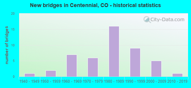
- New bridges - historical statistics
- 11940-1949
- 21950-1959
- 71960-1969
- 61970-1979
- 161980-1989
- 91990-1999
- 52000-2009
- 12010-2019
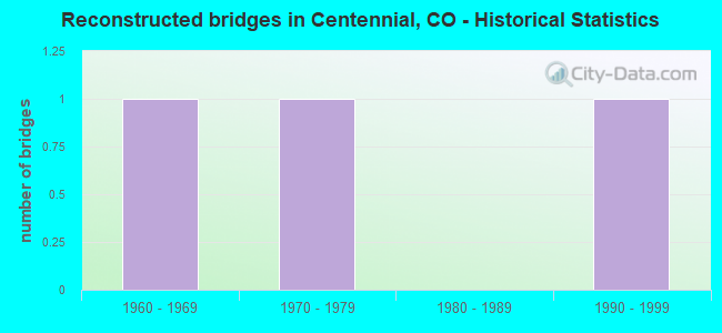
- Reconstructed bridges - Historical Statistics
- 11960-1969
- 11970-1979
- 01980-1989
- 11990-1999
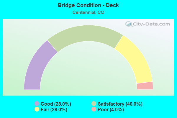
- Bridge Condition - Deck
- 28.0%Good
- 40.0%Satisfactory
- 28.0%Fair
- 4.0%Poor
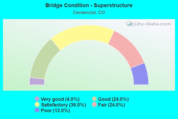
- Bridge Condition - Superstructure
- 4.0%Very good
- 24.0%Good
- 36.0%Satisfactory
- 24.0%Fair
- 12.0%Poor
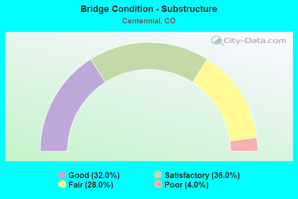
- Bridge Condition - Substructure
- 32.0%Good
- 36.0%Satisfactory
- 28.0%Fair
- 4.0%Poor
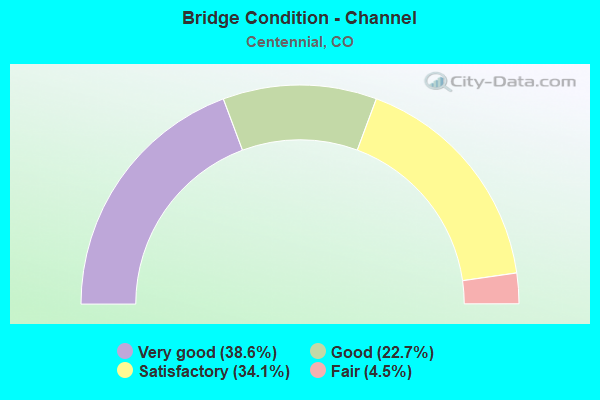
- Bridge Condition - Channel
- 38.6%Very good
- 22.7%Good
- 34.1%Satisfactory
- 4.5%Fair
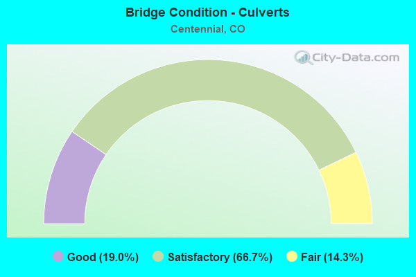
- Bridge Condition - Culverts
- 19.0%Good
- 66.7%Satisfactory
- 14.3%Fair
Find on map >> Show street view
Structure Number: F-17-JL, Location: 1.84 M S OF JCT 88-ARAPHO (Lat: 39.572253, Lng: -104.789083), Route carried "on" structure: State highway 83A, Year Built: 1989, Status: Open, Structure Length: 0.71m (2.33ft), Average Daily Traffic: 41,000 (year 2020), Truck Traffic: 4%, Average Future Daily Traffic: 51,660 (year 2040), Design Load: HS 20+Mod, Features Intersected: WASH, Facility Carried by Structure: SH 83 ML
Minimum Vertical Clearance: 30+ m (98+ ft), Kilometerpoint: 69.511, Lanes on structure: 7, Base Highway Network: Yes, Owner: State Highway Agency, Approaching Roadway Width: 34.1m (111.9ft), Skew: 22 degrees, Material/Design: Concrete, Design/Construction: Culvert, Number Of Spans In Main Unit: 1, Length of Maximum Span: 7.1m (23.3ft), Out-to-Out Width: 50.4m (165.4ft)
Condition: Channel: Good, Culverts: Good, Operating Rating: 36.3 metric tons, Method Used To Determine Operating Rating: Field evaluation and documented engineering judgment, Inventory Rating: 32.7 metric tons, Method Used To Determine Inventory Rating: Field evaluation and documented engineering judgment, Structural Evaluation: Better than present minimum criteria, Waterway Adequacy: Equal to present desirable criteria, Approach Roadway Alignment: Equal to present desirable criteria, Designated Inspection Frequency: Every 48 months, Inspection Date: May 2019
Find on map >> Show street view
Structure Number: F-17-JZ, Location: .85 MI N. JCT I-25 & (Lat: 39.566000, Lng: -104.872594), Route carried "on" structure: Ramp Interstate 25A, Year Built: 1991, Status: Open, Structure Length: 5.52m (18.11ft), Average Daily Traffic: 85,500 (year 2020), Truck Traffic: 7%, Average Future Daily Traffic: 116,280 (year 2040), Design Load: HS 20, Features Intersected: COUNTY LINE ROAD R, Facility Carried by Structure: RAMP TO I 25 SBND
Minimum Vertical Clearance: 30+ m (98+ ft), Kilometerpoint: 0.201, Lanes on structure: 1, Lanes under structure: 7, Base Highway Network: Yes, Owner: State Highway Agency, Approaching Roadway Width: 8.2m (26.9ft), Material/Design: Prestressed concrete continuous, Design/Construction: Stringer/Multi-beam, Number Of Spans In Main Unit: 2, Length of Maximum Span: 28.1m (92.2ft), Curb-To-Curb Width: 8.2m (26.9ft), Out-to-Out Width: 9.1m (29.9ft)
Condition: Deck: Good, Superstructure: Very good, Substructure: Good, Operating Rating: 69.3 metric tons, Method Used To Determine Operating Rating: Load Factor (LF), Inventory Rating: 41.5 metric tons, Method Used To Determine Inventory Rating: Load Factor (LF), Structural Evaluation: Better than present minimum criteria, Deck Geometry: Superior to present desirable criteria, Underclear: High priority of corrective action, Approach Roadway Alignment: Equal to present desirable criteria, Designated Inspection Frequency: Every 24 months, Inspection Date: December 2021, Deck Structure Type: Concrete Cast-file-Place, Wearing Surface/Protective System: Wearing Surface: Bituminous, Membrane: Preformed Fabric, Deck Protection: Epoxy Coated Reinforcing
Find on map >> Show street view
Structure Number: F-17-LW, Location: 1.48 MI E OF JCT I25 (Lat: 39.594850, Lng: -104.859681), Route carried "on" structure: State highway 88B, Year Built: 1976, Year Reconstructed: 1983, Status: Open, Structure Length: 0.99m (3.25ft), Average Daily Traffic: 57,000 (year 2020), Truck Traffic: 4%, Average Future Daily Traffic: 63,840 (year 2040), Design Load: HS 20, Features Intersected: DRAW, Facility Carried by Structure: SH 88 ML/ARAP RD
Minimum Vertical Clearance: 30+ m (98+ ft), Kilometerpoint: 2.322, Lanes on structure: 7, Base Highway Network: Yes, Owner: State Highway Agency, Approaching Roadway Width: 32.3m (106.0ft), Skew: 21 degrees, Material/Design: Concrete, Design/Construction: Culvert, Number Of Spans In Main Unit: 3, Length of Maximum Span: 3.7m (12.1ft), Curb or Sidewalk Widths: Left: 1.5m (4.9ft), Right: 1.7m (5.6ft), Out-to-Out Width: 46.8m (153.5ft)
Condition: Channel: Fair, Culverts: Satisfactory, Operating Rating: 89.8 metric tons, Method Used To Determine Operating Rating: Field evaluation and documented engineering judgment, Inventory Rating: 89.8 metric tons, Method Used To Determine Inventory Rating: Field evaluation and documented engineering judgment, Structural Evaluation: Equal to present minimum criteria, Waterway Adequacy: Better than present minimum criteria, Approach Roadway Alignment: Equal to present desirable criteria, Designated Inspection Frequency: Every 24 months, Inspection Date: September 2020
Find on map >> Show street view
Structure Number: SSPR-01, Location: AT INT. W/UNIVERSITY BLVD (Lat: 39.600739, Lng: -104.958639), Route carried "on" structure: County highway , Year Built: 1999, Status: Open, Structure Length: 1.57m (5.15ft), Average Daily Traffic: 2,042 (year 2021), Truck Traffic: 1%, Average Future Daily Traffic: 2,491 (year 2041), Design Load: HS 25 or greater, Features Intersected: HIGHLINE CANAL, Facility Carried by Structure: GOODSON REC CTR RD
Minimum Vertical Clearance: 30+ m (98+ ft), Kilometerpoint: 4.408, Lanes on structure: 3, Owner: Local Agency, Approaching Roadway Width: 12.2m (40.0ft), Skew: 3 degrees, Material/Design: Prestressed concrete, Design/Construction: Box Beam or Girders - Single/Spread, Number Of Spans In Main Unit: 1, Length of Maximum Span: 11.8m (38.7ft), Curb or Sidewalk Widths: Left: 1.5m (4.9ft), Right: 1.5m (4.9ft), Curb-To-Curb Width: 11.6m (38.1ft), Out-to-Out Width: 15.3m (50.2ft)
Condition: Deck: Satisfactory, Superstructure: Good, Substructure: Good, Channel: Good, Operating Rating: 27.7 metric tons, Method Used To Determine Operating Rating: Load Factor (LF), Inventory Rating: 16.5 metric tons, Method Used To Determine Inventory Rating: Load Factor (LF), Structural Evaluation: Meets minimum limits, Deck Geometry: High priority of replacement, Waterway Adequacy: Equal to present desirable criteria, Approach Roadway Alignment: Equal to present minimum criteria, Length Of Structure Improvement: 1.57m (5.15ft), Designated Inspection Frequency: Every 24 months, Inspection Date: November 2021, Deck Structure Type: Concrete Cast-file-Place, Wearing Surface/Protective System: Wearing Surface: Bituminous, Membrane: Built-up, Deck Protection: Epoxy Coated Reinforcing
Find on map >> Show street view
Structure Number: F-17-IV, Location: 1.7 MI N. OF JCT SH 470 (Lat: 39.580203, Lng: -104.876133), Route carried "under" structure: City street , Year Built: 1987, Structure Length: 0. m, Average Daily Traffic: 12,367 (year 2017), Truck Traffic: 1%, Features Intersected: DRY CREEK RD, Facility Carried by Structure: I 25 ML
Minimum Vertical Clearance: 16.93m (55.54ft), Kilometerpoint: 0.000, Lanes on structure: 10, Lanes under structure: 4, Material/Design: Prestressed concrete continuous, Design/Construction: Stringer/Multi-beam, Length of Maximum Span: 37.5m (123.0ft)