Bridge Statistics for Chambersburg, Pennsylvania (PA)
Condition, Traffic, Stress, Structural Evaluation, Project Costs
- National Bridge Inventory (NBI) Statistics
- 56Number of bridges
- 354ft / 108mTotal length
- $12,781,000Total costs
- 586,857Total average daily traffic
- 157,695Total average daily truck traffic
- National Bridge Inventory (NBI) Registered Bridges for Chambersburg
- No street view available for this location
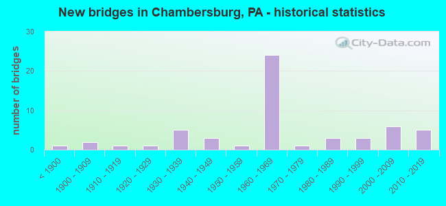
- New bridges - historical statistics
- 1Before 1900
- 21900-1909
- 11910-1919
- 11920-1929
- 51930-1939
- 31940-1949
- 11950-1959
- 241960-1969
- 11970-1979
- 31980-1989
- 31990-1999
- 62000-2009
- 52010-2019

- Reconstructed bridges - Historical Statistics
- 11900-1909
- 01910-1919
- 01920-1929
- 01930-1939
- 01940-1949
- 01950-1959
- 01960-1969
- 11970-1979
- 11980-1989
- 21990-1999
- 32000-2009
- 72010-2019


- Bridge Condition - Deck
- 17.6%Very good
- 41.2%Good
- 20.6%Satisfactory
- 2.9%Fair
- 14.7%Poor
- 2.9%Serious

- Bridge Condition - Superstructure
- 2.8%Excellent
- 25.0%Very good
- 19.4%Good
- 25.0%Satisfactory
- 13.9%Fair
- 11.1%Poor
- 2.8%Serious

- Bridge Condition - Substructure
- 13.9%Very good
- 30.6%Good
- 41.7%Satisfactory
- 13.9%Fair

- Bridge Condition - Channel
- 7.1%Very good
- 32.1%Good
- 28.6%Satisfactory
- 28.6%Fair
- 3.6%Poor

- Bridge Condition - Culverts
- 25.0%Good
- 75.0%Satisfactory
Find on map >> Show street view
Structure Number: DAPAMCLET000015, Location: BTWN LA AVE & E-4 RD (Lat: 39.985511, Lng: -77.704150), Route carried "on" structure: Other road , Year Built: 1943, Status: Open, Structure Length: 1.02m (3.35ft), Average Daily Traffic: 35 (year 2015), Truck Traffic: 10%, Average Future Daily Traffic: 120 (year 2043), Features Intersected: SMALL STREAM, Facility Carried by Structure: GEORGIA AVE
Minimum Vertical Clearance: 30+ m (98+ ft), Kilometerpoint: 0.000, Lanes on structure: 2, Owner: Army, Approaching Roadway Width: 8.4m (27.6ft), Material/Design: Concrete, Design/Construction: Slab, Number Of Spans In Main Unit: 2, Length of Maximum Span: 4.3m (14.1ft), Curb-To-Curb Width: 7.5m (24.6ft), Out-to-Out Width: 8.4m (27.6ft)
Condition: Deck: Satisfactory, Superstructure: Satisfactory, Substructure: Good, Channel: Satisfactory, Operating Rating: 42.6 metric tons, Method Used To Determine Operating Rating: Load and Resistance Factor (LRFR), Inventory Rating: 32.8 metric tons, Method Used To Determine Inventory Rating: Load and Resistance Factor (LRFR), Structural Evaluation: Equal to present minimum criteria, Deck Geometry: Equal to present minimum criteria, Waterway Adequacy: Equal to present desirable criteria, Approach Roadway Alignment: Equal to present desirable criteria, Length Of Structure Improvement: 1.69m (5.54ft), Designated Inspection Frequency: Every 24 months, Inspection Date: September 2021, Bridge Improvement Cost: $2,000, Total Project Cost: $2,000 ( Estimate for 2021), Deck Structure Type: Concrete Cast-file-Place, Wearing Surface/Protective System: Wearing Surface: Bituminous
Find on map >> Show street view
Structure Number: DAPAMCLET000022, Location: SE OF BUILDING 1570 (Lat: 39.980889, Lng: -77.700639), Route carried "on" structure: Other road , Year Built: 1942, Status: Posted for load, Structure Length: 1.17m (3.84ft), Average Daily Traffic: 20 (year 2015), Truck Traffic: 5%, Average Future Daily Traffic: 22 (year 2043), Features Intersected: SMALL STREAM, Facility Carried by Structure: SOUTH PATROL RD
Minimum Vertical Clearance: 30+ m (98+ ft), Kilometerpoint: 0.000, Lanes on structure: 2, Owner: Army, Approaching Roadway Width: 3.7m (12.1ft), Skew: 3 degrees, Material/Design: Concrete, Design/Construction: Slab, Number Of Spans In Main Unit: 2, Length of Maximum Span: 4.9m (16.1ft), Curb-To-Curb Width: 5.8m (19.0ft), Out-to-Out Width: 6.6m (21.7ft)
Condition: Deck: Satisfactory, Superstructure: Satisfactory, Substructure: Good, Channel: Fair, Operating Rating: 17.5 metric tons, Method Used To Determine Operating Rating: Load and Resistance Factor Rating (LRFR) rating reported by rating factor(RF) method using HL-93 loadings, Inventory Rating: 13.3 metric tons, Method Used To Determine Inventory Rating: Load and Resistance Factor Rating (LRFR) rating reported by rating factor(RF) method using HL-93 loadings, Structural Evaluation: Meets minimum limits, Deck Geometry: Meets minimum limits, Waterway Adequacy: Equal to present desirable criteria, Approach Roadway Alignment: Equal to present desirable criteria, Bridge Posting: Required (Relationship of Operating Rating to Maximum Legal Load: > 39.9% below), Length Of Structure Improvement: 1.84m (6.04ft), Designated Inspection Frequency: Every 24 months, Inspection Date: September 2021, Bridge Improvement Cost: $1,000, Total Project Cost: $1,000 ( Estimate for 2021), Deck Structure Type: Concrete Cast-file-Place
Find on map >> Show street view
Structure Number: 17375, Location: 2 ML. N. OF MARION (Lat: 39.892300, Lng: -77.669042), Route carried "under" structure: Interstate 81, Year Built: 1963, Structure Length: 0. m, Average Daily Traffic: 29,266 (year 2021), Truck Traffic: 43%, Features Intersected: I-81; SR 0081, Facility Carried by Structure: T-467; GLFRD SPRNG
Minimum Vertical Clearance: 5.28m (17.32ft), Kilometerpoint: 19.317, Lanes on structure: 2, Lanes under structure: 4, Material/Design: Prestressed concrete, Design/Construction: Box Beam or Girders - Multiple, Length of Maximum Span: 20.7m (67.9ft)
Find on map >> Show street view
Structure Number: 17375, Location: 2 ML. N. OF MARION (Lat: 39.892300, Lng: -77.669042), Route carried "under" structure: Interstate 81, Year Built: 1963, Structure Length: 0. m, Average Daily Traffic: 27,746 (year 2021), Truck Traffic: 45%, Features Intersected: I-81; SR 0081, Facility Carried by Structure: T-467; GLFRD SPRNG
Minimum Vertical Clearance: 5.28m (17.32ft), Kilometerpoint: 19.307, Lanes on structure: 2, Lanes under structure: 4, Material/Design: Prestressed concrete, Design/Construction: Box Beam or Girders - Multiple, Length of Maximum Span: 20.7m (67.9ft)
Find on map >> Show street view
Structure Number: 17377, Location: 2 ML. S.OF CHAMBERSBURG (Lat: 39.901247, Lng: -77.661772), Route carried "under" structure: Interstate 81, Year Built: 1963, Structure Length: 0. m, Average Daily Traffic: 29,266 (year 2021), Truck Traffic: 43%, Features Intersected: I-81; SR 0081, Facility Carried by Structure: T-491; KRINER RD
Minimum Vertical Clearance: 5.28m (17.32ft), Kilometerpoint: 20.925, Lanes on structure: 2, Lanes under structure: 4, Material/Design: Prestressed concrete, Design/Construction: Box Beam or Girders - Multiple, Length of Maximum Span: 19.5m (64.0ft)
Find on map >> Show street view
Structure Number: 17377, Location: 2 ML. S.OF CHAMBERSBURG (Lat: 39.901247, Lng: -77.661772), Route carried "under" structure: Interstate 81, Year Built: 1963, Structure Length: 0. m, Average Daily Traffic: 27,746 (year 2021), Truck Traffic: 45%, Features Intersected: I-81; SR 0081, Facility Carried by Structure: T-491; KRINER RD
Minimum Vertical Clearance: 5.28m (17.32ft), Kilometerpoint: 20.925, Lanes on structure: 2, Lanes under structure: 4, Material/Design: Prestressed concrete, Design/Construction: Box Beam or Girders - Multiple, Length of Maximum Span: 19.5m (64.0ft)
Find on map >> Show street view
Structure Number: 17381, Location: WAYNE AVE. CHAMBERSBURG (Lat: 39.909131, Lng: -77.648561), Route carried "under" structure: State highway 316, Year Built: 1963, Structure Length: 0. m, Average Daily Traffic: 4,065 (year 2020), Truck Traffic: 4%, Features Intersected: PA 316; SR 0316, Facility Carried by Structure: I-81 NB; SR 0081
Minimum Vertical Clearance: 4.48m (14.70ft), Kilometerpoint: 23.960, Lanes on structure: 2, Lanes under structure: 4, Material/Design: Prestressed concrete, Design/Construction: Stringer/Multi-beam, Length of Maximum Span: 21.6m (70.9ft)
Find on map >> Show street view
Structure Number: 17381, Location: WAYNE AVE. CHAMBERSBURG (Lat: 39.909131, Lng: -77.648561), Route carried "under" structure: State highway 316, Year Built: 1963, Structure Length: 0. m, Average Daily Traffic: 4,065 (year 2020), Truck Traffic: 4%, Features Intersected: PA 316; SR 0316, Facility Carried by Structure: I-81 NB; SR 0081
Minimum Vertical Clearance: 4.75m (15.58ft), Kilometerpoint: 23.960, Lanes on structure: 2, Lanes under structure: 4, Material/Design: Prestressed concrete, Design/Construction: Stringer/Multi-beam, Length of Maximum Span: 21.6m (70.9ft)
Find on map >> Show street view
Structure Number: 17382, Location: WAYNE AVE. S.CHAMBERSBURG (Lat: 39.909219, Lng: -77.648975), Route carried "under" structure: State highway 316, Year Built: 1963, Structure Length: 0. m, Average Daily Traffic: 4,065 (year 2020), Truck Traffic: 4%, Features Intersected: PA 316; SR 0316, Facility Carried by Structure: I-81 SB; SR 0081
Minimum Vertical Clearance: 4.54m (14.90ft), Kilometerpoint: 23.960, Lanes on structure: 2, Lanes under structure: 4, Material/Design: Prestressed concrete, Design/Construction: Stringer/Multi-beam, Length of Maximum Span: 21.6m (70.9ft)
Find on map >> Show street view
Structure Number: 17382, Location: WAYNE AVE. S.CHAMBERSBURG (Lat: 39.909219, Lng: -77.648975), Route carried "under" structure: State highway 316, Year Built: 1963, Structure Length: 0. m, Average Daily Traffic: 4,065 (year 2020), Truck Traffic: 4%, Features Intersected: PA 316; SR 0316, Facility Carried by Structure: I-81 SB; SR 0081
Minimum Vertical Clearance: 4.88m (16.01ft), Kilometerpoint: 23.960, Lanes on structure: 2, Lanes under structure: 4, Material/Design: Prestressed concrete, Design/Construction: Stringer/Multi-beam, Length of Maximum Span: 21.6m (70.9ft)
Find on map >> Show street view
Structure Number: 17383, Location: 0.5ML. N. OF WAYNE AVE. (Lat: 39.920203, Lng: -77.639283), Route carried "under" structure: Interstate 81, Year Built: 1963, Structure Length: 0. m, Average Daily Traffic: 24,991 (year 2022), Truck Traffic: 34%, Features Intersected: I-81; SR 0081, Facility Carried by Structure: T-513; MCKINLEY ST
Minimum Vertical Clearance: 5.52m (18.11ft), Kilometerpoint: 24.140, Lanes on structure: 2, Lanes under structure: 4, Material/Design: Prestressed concrete, Design/Construction: Box Beam or Girders - Multiple, Length of Maximum Span: 20.1m (65.9ft)
Find on map >> Show street view
Structure Number: 17383, Location: 0.5ML. N. OF WAYNE AVE. (Lat: 39.920203, Lng: -77.639283), Route carried "under" structure: Interstate 81, Year Built: 1963, Structure Length: 0. m, Average Daily Traffic: 25,332 (year 2022), Truck Traffic: 28%, Features Intersected: I-81; SR 0081, Facility Carried by Structure: T-513; MCKINLEY ST
Minimum Vertical Clearance: 5.13m (16.83ft), Kilometerpoint: 24.147, Lanes on structure: 2, Lanes under structure: 4, Material/Design: Prestressed concrete, Design/Construction: Box Beam or Girders - Multiple, Length of Maximum Span: 20.1m (65.9ft)
Find on map >> Show street view
Structure Number: 17385, Location: U.S.30 CHAMBERSBURG (Lat: 39.929058, Lng: -77.634819), Route carried "under" structure: US 30, Year Built: 1963, Structure Length: 0. m, Average Daily Traffic: 8,779 (year 2020), Truck Traffic: 4%, Features Intersected: US 30; SR 0030, Facility Carried by Structure: I-81 NB; SR 0081
Minimum Vertical Clearance: 5.24m (17.19ft), Kilometerpoint: 30.965, Lanes on structure: 2, Lanes under structure: 4, Material/Design: Prestressed concrete, Design/Construction: Box Beam or Girders - Multiple, Length of Maximum Span: 25.3m (83.0ft)
Find on map >> Show street view
Structure Number: 17385, Location: U.S.30 CHAMBERSBURG (Lat: 39.929058, Lng: -77.634819), Route carried "under" structure: US 30, Year Built: 1963, Structure Length: 0. m, Average Daily Traffic: 8,779 (year 2020), Truck Traffic: 4%, Features Intersected: US 30; SR 0030, Facility Carried by Structure: I-81 NB; SR 0081
Minimum Vertical Clearance: 5.21m (17.09ft), Kilometerpoint: 30.965, Lanes on structure: 2, Lanes under structure: 4, Material/Design: Prestressed concrete, Design/Construction: Box Beam or Girders - Multiple, Length of Maximum Span: 25.3m (83.0ft)
Find on map >> Show street view
Structure Number: 17387, Location: U.S. 30 CHAMBURSBURG (Lat: 39.928956, Lng: -77.635208), Route carried "under" structure: US 30, Year Built: 1963, Structure Length: 0. m, Average Daily Traffic: 8,779 (year 2020), Truck Traffic: 4%, Features Intersected: US 30; SR 0030, Facility Carried by Structure: I-81 SB; SR 0081
Minimum Vertical Clearance: 5.21m (17.09ft), Kilometerpoint: 30.965, Lanes on structure: 2, Lanes under structure: 4, Material/Design: Prestressed concrete, Design/Construction: Box Beam or Girders - Multiple, Length of Maximum Span: 25.3m (83.0ft)
Find on map >> Show street view
Structure Number: 17387, Location: U.S. 30 CHAMBURSBURG (Lat: 39.928956, Lng: -77.635208), Route carried "under" structure: US 30, Year Built: 1963, Structure Length: 0. m, Average Daily Traffic: 8,779 (year 2020), Truck Traffic: 4%, Features Intersected: US 30; SR 0030, Facility Carried by Structure: I-81 SB; SR 0081
Minimum Vertical Clearance: 5.18m (16.99ft), Kilometerpoint: 30.965, Lanes on structure: 2, Lanes under structure: 4, Material/Design: Prestressed concrete, Design/Construction: Box Beam or Girders - Multiple, Length of Maximum Span: 25.3m (83.0ft)
Find on map >> Show street view
Structure Number: 43238, Location: 1 MI.N.OF CHAMBERSBURG (Lat: 39.941206, Lng: -77.622331), Route carried "under" structure: Interstate 81, Year Built: 2005, Structure Length: 0. m, Average Daily Traffic: 24,933 (year 2021), Truck Traffic: 19%, Features Intersected: I-81; SR 0081, Facility Carried by Structure: SR 1010; WALKER RD
Minimum Vertical Clearance: 4.95m (16.24ft), Kilometerpoint: 26.575, Lanes on structure: 3, Lanes under structure: 4, Material/Design: Prestressed concrete continuous, Design/Construction: Box Beam or Girders - Single/Spread, Length of Maximum Span: 26.5m (86.9ft)
Find on map >> Show street view
Structure Number: 43238, Location: 1 MI.N.OF CHAMBERSBURG (Lat: 39.941206, Lng: -77.622331), Route carried "under" structure: Interstate 81, Year Built: 2005, Structure Length: 0. m, Average Daily Traffic: 24,570 (year 2021), Truck Traffic: 18%, Features Intersected: I-81; SR 0081, Facility Carried by Structure: SR 1010; WALKER RD
Minimum Vertical Clearance: 4.95m (16.24ft), Kilometerpoint: 26.570, Lanes on structure: 3, Lanes under structure: 4, Material/Design: Prestressed concrete continuous, Design/Construction: Box Beam or Girders - Single/Spread, Length of Maximum Span: 26.5m (86.9ft)