Bridge Statistics for Champaign, Illinois (IL)
Condition, Traffic, Stress, Structural Evaluation, Project Costs
- National Bridge Inventory (NBI) Statistics
- 128Number of bridges
- 994ft / 303mTotal length
- $5,142,000Total costs
- 1,456,725Total average daily traffic
- 285,480Total average daily truck traffic
- National Bridge Inventory (NBI) Registered Bridges for Champaign
- No street view available for this location
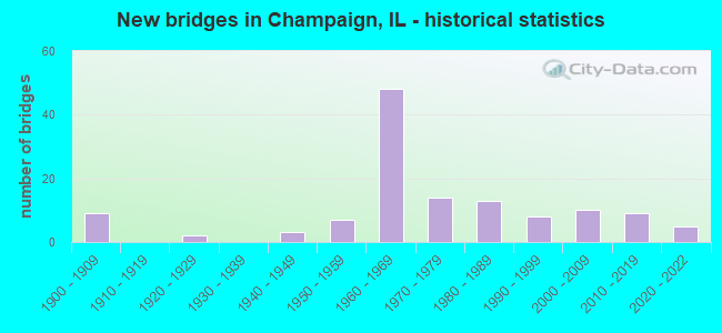
- New bridges - historical statistics
- 91900-1909
- 21920-1929
- 31940-1949
- 71950-1959
- 481960-1969
- 141970-1979
- 131980-1989
- 81990-1999
- 102000-2009
- 92010-2019
- 52020-2022

- Reconstructed bridges - Historical Statistics
- 31980-1989
- 91990-1999
- 42000-2009
- 22010-2019
- 12020-2022


- Bridge Condition - Deck
- 2.8%Excellent
- 8.5%Very good
- 39.4%Good
- 25.4%Satisfactory
- 18.3%Fair
- 5.6%Poor

- Bridge Condition - Superstructure
- 2.8%Excellent
- 11.3%Very good
- 36.6%Good
- 31.0%Satisfactory
- 8.5%Fair
- 9.9%Poor

- Bridge Condition - Substructure
- 2.8%Excellent
- 32.4%Very good
- 36.6%Good
- 19.7%Satisfactory
- 8.5%Fair

- Bridge Condition - Channel
- 39.4%Very good
- 31.8%Good
- 21.2%Satisfactory
- 3.0%Fair
- 4.5%Poor

- Bridge Condition - Culverts
- 15.0%Very good
- 55.0%Good
- 25.0%Satisfactory
- 5.0%Fair
Find on map >> Show street view
Structure Number: 104499, Location: 3 MI NE BONDVILLE (Lat: 40.142128, Lng: -88.328008), Route carried "on" structure: County highway , Year Built: 2002, Status: Open, Structure Length: 2.17m (7.12ft), Average Daily Traffic: 100 (year 2021), Average Future Daily Traffic: 85 (year 2032), Design Load: HS 20, Features Intersected: STREAM, Facility Carried by Structure: TR 163
Minimum Vertical Clearance: 30+ m (98+ ft), Kilometerpoint: 6.791, Lanes on structure: 2, Owner: Town or Township Highway Agency, Approaching Roadway Width: 7.3m (24.0ft), Skew: 1 degrees, Material/Design: Prestressed concrete, Design/Construction: Box Beam or Girders - Multiple, Number Of Spans In Main Unit: 1, Length of Maximum Span: 21.3m (69.9ft), Curb-To-Curb Width: 8.5m (27.9ft), Out-to-Out Width: 8.5m (27.9ft)
Condition: Deck: Good, Superstructure: Good, Substructure: Very good, Channel: Very good, Operating Rating: 44.1 metric tons, Method Used To Determine Operating Rating: Assigned rating based on Load Factor Design (LFD) reported by rating factor (RF) using MS18 loading, Inventory Rating: 32.4 metric tons, Method Used To Determine Inventory Rating: Assigned rating based on Load Factor Design (LFD) reported by rating factor (RF) using MS18 loading, Structural Evaluation: Better than present minimum criteria, Deck Geometry: Better than present minimum criteria, Waterway Adequacy: Equal to present desirable criteria, Approach Roadway Alignment: Equal to present desirable criteria, Designated Inspection Frequency: Every 48 months, Inspection Date: January 2020, Deck Structure Type: Concrete Precast Panels, Wearing Surface/Protective System: Wearing Surface: Gravel
Find on map >> Show street view
Structure Number: 104556, Location: 0.9 Mi E of CH 21 (Lat: 40.160406, Lng: -88.222128), Route carried "on" structure: Other road , Year Built: 2016, Status: Open, Structure Length: 8.28m (27.17ft), Average Daily Traffic: 2,300 (year 2021), Truck Traffic: 22%, Average Future Daily Traffic: 12,400 (year 2033), Design Load: HS 25 or greater, Features Intersected: IC Railroad, Facility Carried by Structure: FAP-813 (Olymp. Dr
Minimum Vertical Clearance: 30+ m (98+ ft), Kilometerpoint: 6.598, Lanes on structure: 2, Base Highway Network: Yes, Owner: City or Municipal Highway Agency, Approaching Roadway Width: 13.4m (44.0ft), Skew: 1 degrees, Material/Design: Steel continuous, Design/Construction: Stringer/Multi-beam, Number Of Spans In Main Unit: 3, Length of Maximum Span: 38.6m (126.6ft), Curb-To-Curb Width: 13.4m (44.0ft), Out-to-Out Width: 14.4m (47.2ft)
Condition: Deck: Very good, Superstructure: Very good, Substructure: Very good, Operating Rating: 42.1 metric tons, Method Used To Determine Operating Rating: Assigned ratings based on Load and Resistance Factor Design (LRFD) reported by rating factor (RF) using HL93 loadings, Inventory Rating: 32.4 metric tons, Method Used To Determine Inventory Rating: Assigned ratings based on Load and Resistance Factor Design (LRFD) reported by rating factor (RF) using HL93 loadings, Structural Evaluation: Equal to present desirable criteria, Deck Geometry: Better than present minimum criteria, Underclear: Equal to present desirable criteria, Approach Roadway Alignment: Equal to present desirable criteria, Designated Inspection Frequency: Every 24 months, Inspection Date: November 2020, Deck Structure Type: Concrete Cast-file-Place
Find on map >> Show street view
Structure Number: 104563, Location: 2.7 MI W of SAVOY (Lat: 40.054908, Lng: -88.307078), Route carried "on" structure: County highway , Year Built: 2014, Status: Open, Structure Length: 0.89m (2.92ft), Average Daily Traffic: 500 (year 2021), Truck Traffic: 4%, Average Future Daily Traffic: 846 (year 2032), Design Load: HS 25 or greater, Features Intersected: Kaskaskia Special, Facility Carried by Structure: TR 225 (1200N)
Minimum Vertical Clearance: 30+ m (98+ ft), Kilometerpoint: 13.309, Lanes on structure: 2, Owner: Town or Township Highway Agency, Approaching Roadway Width: 7.3m (24.0ft), Skew: 2 degrees, Material/Design: Concrete, Design/Construction: Culvert, Number Of Spans In Main Unit: 2, Length of Maximum Span: 4.3m (14.1ft), Curb-To-Curb Width: 12.8m (42.0ft), Out-to-Out Width: 13.4m (44.0ft)
Condition: Channel: Very good, Culverts: Very good, Operating Rating: 42.1 metric tons, Method Used To Determine Operating Rating: Assigned ratings based on Load and Resistance Factor Design (LRFD) reported by rating factor (RF) using HL93 loadings, Inventory Rating: 32.4 metric tons, Method Used To Determine Inventory Rating: Assigned ratings based on Load and Resistance Factor Design (LRFD) reported by rating factor (RF) using HL93 loadings, Structural Evaluation: Equal to present desirable criteria, Deck Geometry: Superior to present desirable criteria, Waterway Adequacy: Equal to present desirable criteria, Approach Roadway Alignment: Equal to present desirable criteria, Designated Inspection Frequency: Every 48 months, Inspection Date: January 2020, Deck Structure Type: Concrete Cast-file-Place, Wearing Surface/Protective System: Deck Protection: Epoxy Coated Reinforcing
Find on map >> Show street view
Structure Number: 104576, Location: 610E, 1000N (Lat: 40.025742, Lng: -88.346569), Route carried "on" structure: County highway , Year Built: 2017, Status: Open, Structure Length: 3.87m (12.70ft), Average Daily Traffic: 3,000 (year 2021), Truck Traffic: 6%, Average Future Daily Traffic: 3,600 (year 2037), Design Load: HS 25 or greater, Features Intersected: Kaskaskia River, Facility Carried by Structure: FAS-531(CH-18)
Minimum Vertical Clearance: 30+ m (98+ ft), Kilometerpoint: 9.945, Lanes on structure: 2, Owner: County Highway Agency, Approaching Roadway Width: 11.0m (36.1ft), Material/Design: Steel continuous, Design/Construction: Stringer/Multi-beam, Number Of Spans In Main Unit: 3, Length of Maximum Span: 14.9m (48.9ft), Curb-To-Curb Width: 9.8m (32.2ft), Out-to-Out Width: 10.7m (35.1ft)
Condition: Deck: Very good, Superstructure: Very good, Substructure: Very good, Channel: Very good, Operating Rating: 42.1 metric tons, Method Used To Determine Operating Rating: Assigned ratings based on Load and Resistance Factor Design (LRFD) reported by rating factor (RF) using HL93 loadings, Inventory Rating: 32.4 metric tons, Method Used To Determine Inventory Rating: Assigned ratings based on Load and Resistance Factor Design (LRFD) reported by rating factor (RF) using HL93 loadings, Structural Evaluation: Equal to present desirable criteria, Deck Geometry: Meets minimum limits, Waterway Adequacy: Equal to present desirable criteria, Approach Roadway Alignment: Equal to present desirable criteria, Designated Inspection Frequency: Every 48 months, Inspection Date: January 2020, Deck Structure Type: Concrete Cast-file-Place, Wearing Surface/Protective System: Deck Protection: Epoxy Coated Reinforcing
Find on map >> Show street view
Structure Number: 10601, Location: DUNCAN S OF SPRNGFLD (Lat: 40.110233, Lng: -88.295411), Route carried "on" structure: Other road , Year Built: 1976, Status: Open, Structure Length: 1.21m (3.97ft), Average Daily Traffic: 7,550 (year 2021), Truck Traffic: 5%, Average Future Daily Traffic: 10,378 (year 2032), Design Load: HS 20+Mod, Features Intersected: COPPER SLOUGH, Facility Carried by Structure: FAU 7155(DUNCAN RD
Minimum Vertical Clearance: 30+ m (98+ ft), Kilometerpoint: 1.867, Lanes on structure: 2, Base Highway Network: Yes, Owner: City or Municipal Highway Agency, Approaching Roadway Width: 9.1m (29.9ft), Material/Design: Prestressed concrete, Design/Construction: Box Beam or Girders - Multiple, Number Of Spans In Main Unit: 1, Length of Maximum Span: 11.4m (37.4ft), Curb-To-Curb Width: 11.7m (38.4ft), Out-to-Out Width: 12.3m (40.4ft)
Condition: Deck: Fair, Superstructure: Fair, Substructure: Satisfactory, Channel: Satisfactory, Operating Rating: 53.8 metric tons, Method Used To Determine Operating Rating: Load Factor (LF) rating reported by rating factor (RF) method using MS18 loading, Inventory Rating: 32.4 metric tons, Method Used To Determine Inventory Rating: Load Factor (LF) rating reported by rating factor (RF) method using MS18 loading, Structural Evaluation: Somewhat better than minimum adequacy, Deck Geometry: Somewhat better than minimum adequacy, Waterway Adequacy: Equal to present desirable criteria, Approach Roadway Alignment: Equal to present desirable criteria, Designated Inspection Frequency: Every 24 months, Inspection Date: September 2021, Deck Structure Type: Concrete Precast Panels, Wearing Surface/Protective System: Wearing Surface: Bituminous, Membrane: Built-up
Find on map >> Show street view
Structure Number: 106202, Location: 0.75 MI S KIRBY AVE (Lat: 40.087311, Lng: -88.276361), Route carried "on" structure: Other road , Year Built: 1977, Status: Open, Structure Length: 1.98m (6.50ft), Average Daily Traffic: 5,500 (year 2021), Truck Traffic: 6%, Average Future Daily Traffic: 6,204 (year 2032), Design Load: HS 20, Features Intersected: PHINNEY BRANCH, Facility Carried by Structure: MATTIS AVE(FAU 715
Minimum Vertical Clearance: 30+ m (98+ ft), Kilometerpoint: 2.848, Lanes on structure: 2, Base Highway Network: Yes, Owner: City or Municipal Highway Agency, Approaching Roadway Width: 12.5m (41.0ft), Skew: 2 degrees, Material/Design: Prestressed concrete, Design/Construction: Box Beam or Girders - Multiple, Number Of Spans In Main Unit: 3, Length of Maximum Span: 7.6m (24.9ft), Curb or Sidewalk Widths: Left: 1.5m (4.9ft), Right: 1.5m (4.9ft), Curb-To-Curb Width: 15.8m (51.8ft), Out-to-Out Width: 23.8m (78.1ft)
Condition: Deck: Fair, Superstructure: Fair, Substructure: Satisfactory, Channel: Satisfactory, Operating Rating: 82.9 metric tons, Method Used To Determine Operating Rating: Load Factor (LF) rating reported by rating factor (RF) method using MS18 loading, Inventory Rating: 49.6 metric tons, Method Used To Determine Inventory Rating: Load Factor (LF) rating reported by rating factor (RF) method using MS18 loading, Structural Evaluation: Somewhat better than minimum adequacy, Deck Geometry: Superior to present desirable criteria, Waterway Adequacy: Equal to present desirable criteria, Approach Roadway Alignment: Equal to present desirable criteria, Designated Inspection Frequency: Every 24 months, Inspection Date: September 2021, Deck Structure Type: Concrete Precast Panels, Wearing Surface/Protective System: Wearing Surface: Latex Concrete, Deck Protection: Epoxy Coated Reinforcing
Find on map >> Show street view
Structure Number: 106203, Location: .25 MI W DUNCAN RD (Lat: 40.109358, Lng: -88.296631), Route carried "on" structure: Other road , Year Built: 1967, Year Reconstructed: 2004, Status: Open, Structure Length: 2.22m (7.28ft), Average Daily Traffic: 2,200 (year 2021), Truck Traffic: 4%, Average Future Daily Traffic: 3,553 (year 2032), Design Load: HS 20, Features Intersected: COPPER SLOUGH, Facility Carried by Structure: JOHN ST (FAU 7128)
Minimum Vertical Clearance: 30+ m (98+ ft), Kilometerpoint: 0.451, Lanes on structure: 2, Owner: City or Municipal Highway Agency, Approaching Roadway Width: 8.5m (27.9ft), Material/Design: Concrete, Design/Construction: Channel Beam, Number Of Spans In Main Unit: 3, Length of Maximum Span: 7.1m (23.3ft), Curb or Sidewalk Widths: Left: 1.0m (3.3ft), Right: 1.0m (3.3ft), Curb-To-Curb Width: 8.4m (27.6ft), Out-to-Out Width: 10.2m (33.5ft)
Condition: Deck: Satisfactory, Superstructure: Satisfactory, Substructure: Satisfactory, Channel: Very good, Operating Rating: 60.6 metric tons, Method Used To Determine Operating Rating: Load Factor (LF) rating reported by rating factor (RF) method using MS18 loading, Inventory Rating: 36.3 metric tons, Method Used To Determine Inventory Rating: Load Factor (LF) rating reported by rating factor (RF) method using MS18 loading, Structural Evaluation: Equal to present minimum criteria, Deck Geometry: High priority of corrective action, Waterway Adequacy: Better than present minimum criteria, Approach Roadway Alignment: Better than present minimum criteria, Length Of Structure Improvement: 2.87m (9.42ft), Designated Inspection Frequency: Every 24 months, Inspection Date: September 2020, Bridge Improvement Cost: $213,000, Roadway Improvement Cost: $21,000, Total Project Cost: $320,000, Deck Structure Type: Concrete Precast Panels, Wearing Surface/Protective System: Wearing Surface: Integral Concrete, Deck Protection: Epoxy Coated Reinforcing
Find on map >> Show street view
Structure Number: 106204, Location: .25 MI W DUNCAN RD (Lat: 40.106100, Lng: -88.296883), Route carried "on" structure: City street , Year Built: 1966, Year Reconstructed: 2004, Status: Open, Structure Length: 2.22m (7.28ft), Average Daily Traffic: 950 (year 2021), Truck Traffic: 6%, Average Future Daily Traffic: 1,636 (year 2032), Design Load: HS 20, Features Intersected: COPPER SLOUGH, Facility Carried by Structure: WILLIAM ST
Minimum Vertical Clearance: 30+ m (98+ ft), Kilometerpoint: 0.612, Lanes on structure: 2, Owner: City or Municipal Highway Agency, Approaching Roadway Width: 8.5m (27.9ft), Material/Design: Concrete, Design/Construction: Channel Beam, Number Of Spans In Main Unit: 3, Length of Maximum Span: 7.1m (23.3ft), Curb or Sidewalk Widths: Left: 1.0m (3.3ft), Right: 1.0m (3.3ft), Curb-To-Curb Width: 8.4m (27.6ft), Out-to-Out Width: 10.2m (33.5ft)
Condition: Deck: Satisfactory, Superstructure: Satisfactory, Substructure: Satisfactory, Channel: Good, Operating Rating: 60.6 metric tons, Method Used To Determine Operating Rating: Load Factor (LF) rating reported by rating factor (RF) method using MS18 loading, Inventory Rating: 36.3 metric tons, Method Used To Determine Inventory Rating: Load Factor (LF) rating reported by rating factor (RF) method using MS18 loading, Structural Evaluation: Equal to present minimum criteria, Deck Geometry: Somewhat better than minimum adequacy, Waterway Adequacy: Better than present minimum criteria, Approach Roadway Alignment: Equal to present desirable criteria, Designated Inspection Frequency: Every 24 months, Inspection Date: September 2020, Deck Structure Type: Concrete Precast Panels, Wearing Surface/Protective System: Wearing Surface: Integral Concrete, Deck Protection: Epoxy Coated Reinforcing
Find on map >> Show street view
Structure Number: 106205, Location: 0.2 MI W of 1st St. (Lat: 40.083428, Lng: -88.242192), Route carried "on" structure: Other road , Year Built: 1989, Status: Open, Structure Length: 1.19m (3.90ft), Average Daily Traffic: 13,700 (year 2021), Truck Traffic: 4%, Average Future Daily Traffic: 16,582 (year 2032), Design Load: HS 20+Mod, Features Intersected: DITCH, Facility Carried by Structure: WINDSOR RD(FAU 714
Minimum Vertical Clearance: 30+ m (98+ ft), Kilometerpoint: 0.402, Lanes on structure: 4, Base Highway Network: Yes, Owner: City or Municipal Highway Agency, Approaching Roadway Width: 17.1m (56.1ft), Skew: 1 degrees, Material/Design: Concrete, Design/Construction: Culvert, Number Of Spans In Main Unit: 3, Length of Maximum Span: 3.7m (12.1ft)
Condition: Channel: Satisfactory, Culverts: Good, Operating Rating: 64.8 metric tons, Method Used To Determine Operating Rating: Load Factor (LF) rating reported by rating factor (RF) method using MS18 loading, Inventory Rating: 38.9 metric tons, Method Used To Determine Inventory Rating: Load Factor (LF) rating reported by rating factor (RF) method using MS18 loading, Structural Evaluation: Better than present minimum criteria, Waterway Adequacy: Equal to present desirable criteria, Approach Roadway Alignment: Equal to present desirable criteria, Designated Inspection Frequency: Every 48 months, Inspection Date: September 2021, Wearing Surface/Protective System: Wearing Surface: Integral Concrete
Find on map >> Show street view
Structure Number: 106208, Location: 0.15 MI N of Windsor (Lat: 40.084803, Lng: -88.249731), Route carried "on" structure: City street , Year Built: 1997, Status: Open, Structure Length: 1.28m (4.20ft), Average Daily Traffic: 1,250 (year 2021), Truck Traffic: 4%, Average Future Daily Traffic: 3,102 (year 2032), Design Load: HS 20, Features Intersected: DRAINAGE DITCH, Facility Carried by Structure: FOX DR(MS 8558)
Minimum Vertical Clearance: 30+ m (98+ ft), Kilometerpoint: 1.336, Lanes on structure: 2, Owner: City or Municipal Highway Agency, Approaching Roadway Width: 10.4m (34.1ft), Material/Design: Prestressed concrete, Design/Construction: Box Beam or Girders - Multiple, Number Of Spans In Main Unit: 1, Length of Maximum Span: 12.1m (39.7ft), Curb or Sidewalk Widths: Left: 0.0m, Right: 2.4m (7.9ft), Curb-To-Curb Width: 10.9m (35.8ft), Out-to-Out Width: 13.4m (44.0ft)
Condition: Deck: Satisfactory, Superstructure: Satisfactory, Substructure: Good, Channel: Very good, Operating Rating: 63.2 metric tons, Method Used To Determine Operating Rating: Load Factor (LF) rating reported by rating factor (RF) method using MS18 loading, Inventory Rating: 37.9 metric tons, Method Used To Determine Inventory Rating: Load Factor (LF) rating reported by rating factor (RF) method using MS18 loading, Structural Evaluation: Equal to present minimum criteria, Deck Geometry: Equal to present minimum criteria, Waterway Adequacy: Equal to present desirable criteria, Approach Roadway Alignment: Equal to present desirable criteria, Designated Inspection Frequency: Every 24 months, Inspection Date: September 2021, Deck Structure Type: Concrete Precast Panels, Wearing Surface/Protective System: Wearing Surface: Bituminous, Membrane: Built-up
Find on map >> Show street view
Structure Number: 106805, Location: .7MI SE KIRBY/DUNCAN (Lat: 40.095114, Lng: -88.283289), Route carried "on" structure: City street , Year Built: 2004, Status: Open, Structure Length: 2.16m (7.09ft), Average Daily Traffic: 450 (year 2021), Truck Traffic: 2%, Average Future Daily Traffic: 2,933 (year 2032), Design Load: H 15, Features Intersected: PHINNEY BRANCH, Facility Carried by Structure: CRESCENT DR/ PED B
Minimum Vertical Clearance: 30+ m (98+ ft), Kilometerpoint: 1.786, Lanes on structure: 2, Owner: City or Municipal Highway Agency, Approaching Roadway Width: 8.5m (27.9ft), Material/Design: Prestressed concrete, Design/Construction: Box Beam or Girders - Multiple, Number Of Spans In Main Unit: 3, Length of Maximum Span: 9.1m (29.9ft), Curb-To-Curb Width: 8.5m (27.9ft), Out-to-Out Width: 8.5m (27.9ft)
Condition: Deck: Satisfactory, Superstructure: Satisfactory, Substructure: Good, Channel: Satisfactory, Operating Rating: 66.4 metric tons, Method Used To Determine Operating Rating: Load Factor (LF) rating reported by rating factor (RF) method using MS18 loading, Inventory Rating: 39.9 metric tons, Method Used To Determine Inventory Rating: Load Factor (LF) rating reported by rating factor (RF) method using MS18 loading, Structural Evaluation: Equal to present minimum criteria, Deck Geometry: Somewhat better than minimum adequacy, Waterway Adequacy: Equal to present desirable criteria, Approach Roadway Alignment: Equal to present desirable criteria, Designated Inspection Frequency: Every 24 months, Inspection Date: September 2021, Deck Structure Type: Concrete Precast Panels, Wearing Surface/Protective System: Wearing Surface: Integral Concrete, Deck Protection: Epoxy Coated Reinforcing
Find on map >> Show street view
Structure Number: 109902, Location: 0.3 S KIRBY AVE (Lat: 40.094233, Lng: -88.287122), Route carried "on" structure: Other road , Year Built: 1900, Year Reconstructed: 2008, Status: Posted for load, Structure Length: 2.19m (7.19ft), Average Daily Traffic: 900 (year 2021), Truck Traffic: 4%, Average Future Daily Traffic: 1,692 (year 2032), Features Intersected: PHINNEY BRANCH, Facility Carried by Structure: FAU 7202/SCOTTSDAL
Minimum Vertical Clearance: 30+ m (98+ ft), Kilometerpoint: 0.483, Lanes on structure: 2, Owner: City or Municipal Highway Agency, Approaching Roadway Width: 8.5m (27.9ft), Material/Design: Concrete, Design/Construction: Channel Beam, Number Of Spans In Main Unit: 3, Length of Maximum Span: 7.3m (24.0ft), Curb or Sidewalk Widths: Left: 1.2m (3.9ft), Right: 1.2m (3.9ft), Curb-To-Curb Width: 8.5m (27.9ft), Out-to-Out Width: 11.4m (37.4ft)
Condition: Deck: Good, Superstructure: Good, Substructure: Good, Channel: Very good, Operating Rating: 29.2 metric tons, Method Used To Determine Operating Rating: Load Factor (LF) rating reported by rating factor (RF) method using MS18 loading, Inventory Rating: 17.5 metric tons, Method Used To Determine Inventory Rating: Load Factor (LF) rating reported by rating factor (RF) method using MS18 loading, Structural Evaluation: Meets minimum limits, Deck Geometry: Somewhat better than minimum adequacy, Waterway Adequacy: Better than present minimum criteria, Approach Roadway Alignment: Equal to present minimum criteria, Designated Inspection Frequency: Every 24 months, Inspection Date: September 2021, Deck Structure Type: Concrete Cast-file-Place, Wearing Surface/Protective System: Wearing Surface: Other, Deck Protection: Epoxy Coated Reinforcing
Find on map >> Show street view
Structure Number: 100009, Location: W OF CHAMPAIGN (Lat: 40.113161, Lng: -88.304839), Route carried "under" structure: State highway 10, Year Built: 1964, Structure Length: 0. m, Average Daily Traffic: 8,600 (year 2021), Truck Traffic: 7%, Features Intersected: ILL 10 & IC RR, Facility Carried by Structure: I-57(NB)
Minimum Vertical Clearance: 7.72m (25.33ft), Kilometerpoint: 143.035, Lanes on structure: 2, Lanes under structure: 2, Material/Design: Steel continuous, Design/Construction: Stringer/Multi-beam, Length of Maximum Span: 16.9m (55.4ft)
Find on map >> Show street view
Structure Number: 10001, Location: W OF CHAMPAIGN (Lat: 40.113161, Lng: -88.305144), Route carried "under" structure: State highway 10, Year Built: 1964, Structure Length: 0. m, Average Daily Traffic: 8,600 (year 2021), Truck Traffic: 7%, Features Intersected: ILL 10 & IC RR, Facility Carried by Structure: I-57(SB)
Minimum Vertical Clearance: 7.70m (25.26ft), Kilometerpoint: 143.002, Lanes on structure: 2, Lanes under structure: 2, Material/Design: Steel continuous, Design/Construction: Stringer/Multi-beam, Length of Maximum Span: 16.9m (55.4ft)
Find on map >> Show street view
Structure Number: 100011, Location: W OF CHAMPAIGN (Lat: 40.139725, Lng: -88.290978), Route carried "under" structure: Interstate 57, Year Built: 1965, Structure Length: 0. m, Average Daily Traffic: 41,000 (year 2021), Truck Traffic: 28%, Features Intersected: I-57, Facility Carried by Structure: CNRL RR
Minimum Vertical Clearance: 5.08m (16.67ft), Kilometerpoint: 380.825, Lanes under structure: 4, Material/Design: Steel, Design/Construction: Girder and Floorbeam System, Length of Maximum Span: 21.5m (70.5ft)
Find on map >> Show street view
Structure Number: 100018, Location: NW OF CHAMPAIGN (Lat: 40.145906, Lng: -88.283886), Route carried "under" structure: Interstate 57, Year Built: 1965, Structure Length: 0. m, Average Daily Traffic: 41,000 (year 2021), Truck Traffic: 28%, Features Intersected: I-57, Facility Carried by Structure: I-74(EB)
Minimum Vertical Clearance: 5.05m (16.57ft), Kilometerpoint: 381.774, Lanes on structure: 3, Lanes under structure: 6, Material/Design: Steel continuous, Design/Construction: Stringer/Multi-beam, Length of Maximum Span: 25.7m (84.3ft)
Find on map >> Show street view
Structure Number: 100019, Location: NW OF CHAMPAIGN (Lat: 40.145989, Lng: -88.283800), Route carried "under" structure: Interstate 57, Year Built: 1965, Structure Length: 0. m, Average Daily Traffic: 25,500 (year 2021), Truck Traffic: 30%, Features Intersected: I-57, Facility Carried by Structure: I-74(WB)
Minimum Vertical Clearance: 5.23m (17.16ft), Kilometerpoint: 381.806, Lanes on structure: 3, Lanes under structure: 6, Material/Design: Steel continuous, Design/Construction: Stringer/Multi-beam, Length of Maximum Span: 25.7m (84.3ft)
Find on map >> Show street view
Structure Number: 10002, Location: CHAMPAIGN (Lat: 40.134914, Lng: -88.238911), Route carried "under" structure: Other road , Year Built: 1957, Structure Length: 0. m, Average Daily Traffic: 10,500 (year 2021), Truck Traffic: 8%, Features Intersected: MARKET ST(FAU 7169), Facility Carried by Structure: I-74
Minimum Vertical Clearance: 4.32m (14.17ft), Kilometerpoint: 3.380, Lanes on structure: 6, Lanes under structure: 2, Material/Design: Steel continuous, Design/Construction: Stringer/Multi-beam, Length of Maximum Span: 20.3m (66.6ft)
Find on map >> Show street view
Structure Number: 100034, Location: W OF CHAMPAIGN (Lat: 40.119775, Lng: -88.304875), Route carried "under" structure: Interstate 57, Year Built: 1965, Structure Length: 0. m, Average Daily Traffic: 31,500 (year 2021), Truck Traffic: 28%, Features Intersected: I-57, Facility Carried by Structure: I-72(EB)
Minimum Vertical Clearance: 5.13m (16.83ft), Kilometerpoint: 378.218, Lanes on structure: 3, Lanes under structure: 6, Material/Design: Steel continuous, Design/Construction: Stringer/Multi-beam, Length of Maximum Span: 25.7m (84.3ft)
Find on map >> Show street view
Structure Number: 100035, Location: W OF CHAMPAIGN (Lat: 40.119878, Lng: -88.304875), Route carried "under" structure: Interstate 57, Year Built: 1965, Structure Length: 0. m, Average Daily Traffic: 41,000 (year 2021), Truck Traffic: 28%, Features Intersected: I-57, Facility Carried by Structure: I-72(WB)
Minimum Vertical Clearance: 4.95m (16.24ft), Kilometerpoint: 378.250, Lanes on structure: 3, Lanes under structure: 6, Material/Design: Steel continuous, Design/Construction: Stringer/Multi-beam, Length of Maximum Span: 25.7m (84.3ft)
Find on map >> Show street view
Structure Number: 100103, Location: W OF CHAMPAIGN (Lat: 40.098589, Lng: -88.304661), Route carried "under" structure: Interstate 57, Year Built: 1963, Structure Length: 0. m, Average Daily Traffic: 31,500 (year 2021), Truck Traffic: 28%, Features Intersected: I-57, Facility Carried by Structure: FAU 7138
Minimum Vertical Clearance: 4.95m (16.24ft), Kilometerpoint: 375.852, Lanes on structure: 2, Lanes under structure: 4, Material/Design: Steel continuous, Design/Construction: Stringer/Multi-beam, Length of Maximum Span: 20.5m (67.3ft)
Find on map >> Show street view
Structure Number: 100104, Location: KIRBY AVE & US 45 (Lat: 40.098086, Lng: -88.243922), Route carried "under" structure: Other road , Year Built: 1959, Structure Length: 0. m, Average Daily Traffic: 14,700 (year 2021), Truck Traffic: 7%, Features Intersected: FAU 7138(KIRBY AVE), Facility Carried by Structure: IC RR
Minimum Vertical Clearance: 4.45m (14.60ft), Kilometerpoint: 6.003, Lanes under structure: 4, Material/Design: Steel, Design/Construction: Girder and Floorbeam System, Length of Maximum Span: 13.0m (42.7ft)
Find on map >> Show street view
Structure Number: 100105, Location: 2.5 MI W OF SAVOY (Lat: 40.054900, Lng: -88.303542), Route carried "under" structure: Interstate 57, Year Built: 1963, Structure Length: 0. m, Average Daily Traffic: 27,700 (year 2021), Truck Traffic: 32%, Features Intersected: I-57, Facility Carried by Structure: TR 225
Minimum Vertical Clearance: 5.00m (16.40ft), Kilometerpoint: 370.992, Lanes on structure: 2, Lanes under structure: 4, Material/Design: Steel continuous, Design/Construction: Stringer/Multi-beam, Length of Maximum Span: 20.5m (67.3ft)
Find on map >> Show street view
Structure Number: 100132, Location: CHAMPAIGN (Lat: 40.134711, Lng: -88.243650), Route carried "under" structure: Interstate 74, Year Built: 1956, Structure Length: 0. m, Average Daily Traffic: 61,200 (year 2019), Truck Traffic: 14%, Features Intersected: I-74, Facility Carried by Structure: NEIL ST(FAU 7166)
Minimum Vertical Clearance: 5.13m (16.83ft), Kilometerpoint: 294.792, Lanes on structure: 4, Lanes under structure: 4, Material/Design: Steel continuous, Design/Construction: Stringer/Multi-beam, Length of Maximum Span: 19.9m (65.3ft)
Find on map >> Show street view
Structure Number: 100148, Location: WASHINGTON ST CHAMP (Lat: 40.119917, Lng: -88.239056), Route carried "under" structure: Other road , Year Built: 1900, Structure Length: 0. m, Average Daily Traffic: 8,350 (year 2021), Truck Traffic: 2%, Features Intersected: WASH ST (FAU 7113), Facility Carried by Structure: IC RR
Minimum Vertical Clearance: 3.23m (10.60ft), Kilometerpoint: 0.370, Lanes under structure: 2, Material/Design: Concrete, Design/Construction: Slab, Length of Maximum Span: 8.5m (27.9ft)
Find on map >> Show street view
Structure Number: 100166, Location: NW OF STALEY (Lat: 40.120400, Lng: -88.333403), Route carried "under" structure: Interstate 72, Year Built: 1969, Structure Length: 0. m, Average Daily Traffic: 15,500 (year 2021), Truck Traffic: 20%, Features Intersected: I-72, Facility Carried by Structure: TR 94
Minimum Vertical Clearance: 5.03m (16.50ft), Kilometerpoint: 290.591, Lanes on structure: 2, Lanes under structure: 4, Material/Design: Steel continuous, Design/Construction: Stringer/Multi-beam, Length of Maximum Span: 20.5m (67.3ft)
Find on map >> Show street view
Structure Number: 100168, Location: N OF STALEY (Lat: 40.119981, Lng: -88.314600), Route carried "under" structure: Interstate 72, Year Built: 1968, Structure Length: 0. m, Average Daily Traffic: 15,500 (year 2021), Truck Traffic: 20%, Features Intersected: I-72, Facility Carried by Structure: CH 57(FAU 7154)
Minimum Vertical Clearance: 5.00m (16.40ft), Kilometerpoint: 292.201, Lanes on structure: 2, Lanes under structure: 4, Material/Design: Steel continuous, Design/Construction: Stringer/Multi-beam, Length of Maximum Span: 20.5m (67.3ft)
Find on map >> Show street view
Structure Number: 100169, Location: NW OF CHAMPAIGN (Lat: 40.158169, Lng: -88.298111), Route carried "under" structure: Interstate 74, Year Built: 1966, Structure Length: 0. m, Average Daily Traffic: 34,200 (year 2021), Truck Traffic: 26%, Features Intersected: I-74, Facility Carried by Structure: DUNCAN RD
Minimum Vertical Clearance: 5.66m (18.57ft), Kilometerpoint: 289.175, Lanes on structure: 2, Lanes under structure: 4, Material/Design: Steel continuous, Design/Construction: Stringer/Multi-beam, Length of Maximum Span: 17.4m (57.1ft)
Find on map >> Show street view
Structure Number: 10017, Location: W OF CHAMPAIGN (Lat: 40.119767, Lng: -88.295542), Route carried "under" structure: Other road , Year Built: 1966, Structure Length: 0. m, Average Daily Traffic: 10,700 (year 2021), Truck Traffic: 9%, Features Intersected: FAP 725, Facility Carried by Structure: DUNCAN RD(FAU 7155
Minimum Vertical Clearance: 4.93m (16.17ft), Kilometerpoint: 0.805, Lanes on structure: 2, Lanes under structure: 4, Material/Design: Steel continuous, Design/Construction: Stringer/Multi-beam, Length of Maximum Span: 20.5m (67.3ft)
Find on map >> Show street view
Structure Number: 100171, Location: 2 MI N CHAMPAIGN (Lat: 40.168911, Lng: -88.257639), Route carried "under" structure: Interstate 57, Year Built: 1967, Structure Length: 0. m, Average Daily Traffic: 23,800 (year 2021), Truck Traffic: 29%, Features Intersected: I-57, Facility Carried by Structure: TR 146
Minimum Vertical Clearance: 4.98m (16.34ft), Kilometerpoint: 385.154, Lanes on structure: 2, Lanes under structure: 4, Material/Design: Steel continuous, Design/Construction: Stringer/Multi-beam, Length of Maximum Span: 24.0m (78.7ft)
Find on map >> Show street view
Structure Number: 100185, Location: N OF CHAMPAIGN (Lat: 40.181289, Lng: -88.245081), Route carried "under" structure: Interstate 57, Year Built: 1968, Structure Length: 0. m, Average Daily Traffic: 26,000 (year 2021), Truck Traffic: 28%, Features Intersected: I-57, Facility Carried by Structure: MARKET ST(FAS533)
Minimum Vertical Clearance: 5.11m (16.77ft), Kilometerpoint: 386.892, Lanes on structure: 2, Lanes under structure: 4, Material/Design: Steel continuous, Design/Construction: Stringer/Multi-beam, Length of Maximum Span: 20.8m (68.2ft)
Find on map >> Show street view
Structure Number: 100186, Location: CHAMPAIGN (Lat: 40.134936, Lng: -88.258086), Route carried "under" structure: Interstate 74, Year Built: 1957, Structure Length: 0. m, Average Daily Traffic: 48,900 (year 2021), Truck Traffic: 19%, Features Intersected: I-74, Facility Carried by Structure: FAU7197FAP804(PROS
Minimum Vertical Clearance: 5.26m (17.26ft), Kilometerpoint: 293.569, Lanes on structure: 6, Lanes under structure: 4, Material/Design: Steel continuous, Design/Construction: Stringer/Multi-beam, Length of Maximum Span: 15.8m (51.8ft)
Find on map >> Show street view
Structure Number: 100187, Location: CHAMPAIGN E OF NEIL (Lat: 40.112608, Lng: -88.241914), Route carried "under" structure: US 45, Year Built: 1926, Structure Length: 0. m, Average Daily Traffic: 10,200 (year 2021), Truck Traffic: 3%, Features Intersected: SPRINGFIELD(FAP 808), Facility Carried by Structure: IC RR
Minimum Vertical Clearance: 3.86m (12.66ft), Kilometerpoint: 395.695, Lanes under structure: 3, Material/Design: Steel, Design/Construction: Girder and Floorbeam System, Length of Maximum Span: 21.3m (69.9ft)
Find on map >> Show street view
Structure Number: 100188, Location: CHAMPAIGN E OF NEIL (Lat: 40.112611, Lng: -88.241703), Route carried "under" structure: US 45, Year Built: 1926, Structure Length: 0. m, Average Daily Traffic: 10,200 (year 2021), Truck Traffic: 3%, Features Intersected: SPRINGFIELD(FAP 808), Facility Carried by Structure: IC RR
Minimum Vertical Clearance: 3.89m (12.76ft), Kilometerpoint: 395.727, Lanes under structure: 3, Material/Design: Concrete, Design/Construction: Slab, Length of Maximum Span: 10.4m (34.1ft)
Find on map >> Show street view
Structure Number: 100254, Location: .25 MI N CHAMPAIGN (Lat: 40.156989, Lng: -88.271281), Route carried "under" structure: Interstate 57, Year Built: 1988, Structure Length: 0. m, Average Daily Traffic: 23,800 (year 2021), Truck Traffic: 29%, Features Intersected: I-57, Facility Carried by Structure: FAP 813
Minimum Vertical Clearance: 5.00m (16.40ft), Kilometerpoint: 383.384, Lanes on structure: 4, Lanes under structure: 4, Material/Design: Steel continuous, Design/Construction: Stringer/Multi-beam, Length of Maximum Span: 32.9m (107.9ft)
Find on map >> Show street view
Structure Number: 100272, Location: CURTIS RD/I-57 (Lat: 40.069400, Lng: -88.303697), Route carried "under" structure: Interstate 57, Year Built: 2007, Structure Length: 0. m, Average Daily Traffic: 31,500 (year 2021), Truck Traffic: 28%, Features Intersected: I-57, Facility Carried by Structure: CURTIS RD
Minimum Vertical Clearance: 5.49m (18.01ft), Kilometerpoint: 372.617, Lanes on structure: 4, Lanes under structure: 4, Material/Design: Prestressed concrete continuous, Design/Construction: Stringer/Multi-beam, Length of Maximum Span: 32.9m (107.9ft)
Find on map >> Show street view
Structure Number: 100291, Location: SW OF CHAMPAIGN (Lat: 40.084031, Lng: -88.304439), Route carried "under" structure: Interstate 57, Year Built: 2012, Structure Length: 0. m, Average Daily Traffic: 31,500 (year 2021), Truck Traffic: 28%, Features Intersected: I-57, Facility Carried by Structure: FAU 7144(WINDSOR R
Minimum Vertical Clearance: 5.26m (17.26ft), Kilometerpoint: 374.227, Lanes on structure: 2, Lanes under structure: 4, Material/Design: Steel continuous, Design/Construction: Stringer/Multi-beam, Length of Maximum Span: 32.4m (106.3ft)
Find on map >> Show street view
Structure Number: 100294, Location: W of Champaign (Lat: 40.127669, Lng: -88.303881), Route carried "under" structure: Interstate 57, Year Built: 2019, Structure Length: 0. m, Average Daily Traffic: 41,000 (year 2021), Truck Traffic: 28%, Features Intersected: I-57, Facility Carried by Structure: FAU 7110(Bradley A
Minimum Vertical Clearance: 5.11m (16.77ft), Kilometerpoint: 379.087, Lanes on structure: 2, Lanes under structure: 4, Material/Design: Steel continuous, Design/Construction: Stringer/Multi-beam, Length of Maximum Span: 37.6m (123.4ft)
Find on map >> Show street view
Structure Number: 10105, Location: I-57 UNDER US 150 (Lat: 40.142919, Lng: -88.287314), Route carried "under" structure: Interstate 57, Year Built: 2020, Structure Length: 0. m, Average Daily Traffic: 41,000 (year 2021), Truck Traffic: 28%, Features Intersected: FAI 57, Facility Carried by Structure: FAP 719 (US 150)
Minimum Vertical Clearance: 4.88m (16.01ft), Kilometerpoint: 381.324, Lanes on structure: 2, Lanes under structure: 4, Material/Design: Steel, Design/Construction: Stringer/Multi-beam, Length of Maximum Span: 54.3m (178.1ft)
Find on map >> Show street view
Structure Number: 1011, Location: I-57 & MATTIS AVE (Lat: 40.151961, Lng: -88.277019), Route carried "under" structure: Interstate 57, Year Built: 2020, Structure Length: 0. m, Average Daily Traffic: 25,500 (year 2021), Truck Traffic: 30%, Features Intersected: FAI 57, Facility Carried by Structure: FAU 7158 (MATTIS A
Minimum Vertical Clearance: 5.11m (16.77ft), Kilometerpoint: 382.643, Lanes on structure: 2, Lanes under structure: 4, Material/Design: Steel, Design/Construction: Stringer/Multi-beam, Length of Maximum Span: 55.0m (180.4ft)
Find on map >> Show street view
Structure Number: 10127, Location: 2.5 MI NW CHAMPAIGN (Lat: 40.140792, Lng: -88.277297), Route carried "under" structure: Interstate 74, Year Built: 2020, Structure Length: 0. m, Average Daily Traffic: 41,000 (year 2021), Truck Traffic: 23%, Features Intersected: FAI 74, Facility Carried by Structure: FAU 7158(MATTIS AV
Minimum Vertical Clearance: 5.11m (16.77ft), Kilometerpoint: 291.766, Lanes on structure: 4, Lanes under structure: 4, Material/Design: Steel, Design/Construction: Stringer/Multi-beam, Length of Maximum Span: 52.6m (172.6ft)
Find on map >> Show street view
Structure Number: 109904, Location: UNIVERSITY AVE (Lat: 40.116328, Lng: -88.240097), Route carried "under" structure: Other road , Year Built: 1900, Structure Length: 0. m, Average Daily Traffic: 12,800 (year 2021), Truck Traffic: 4%, Features Intersected: FAU 7118, Facility Carried by Structure: IC RR
Minimum Vertical Clearance: 4.45m (14.60ft), Kilometerpoint: 3.170, Lanes under structure: 2, Material/Design: Concrete, Length of Maximum Span: 7.9m (25.9ft)
Find on map >> Show street view
Structure Number: 109905, Location: LOGAN ST (Lat: 40.114911, Lng: -88.241489), Route carried "under" structure: City street , Year Built: 1900, Structure Length: 0. m, Average Daily Traffic: 900 (year 2021), Truck Traffic: 18%, Features Intersected: LOGAN ST, Facility Carried by Structure: IC RR
Minimum Vertical Clearance: 3.63m (11.91ft), Kilometerpoint: 2.156, Lanes under structure: 2, Material/Design: Concrete, Length of Maximum Span: 8.5m (27.9ft)
Find on map >> Show street view
Structure Number: 109906, Location: LOGAN ST (Lat: 40.114797, Lng: -88.240969), Route carried "under" structure: City street , Year Built: 1900, Structure Length: 0. m, Average Daily Traffic: 900 (year 2021), Truck Traffic: 18%, Features Intersected: LOGAN ST, Facility Carried by Structure: IC RR
Minimum Vertical Clearance: 3.63m (11.91ft), Kilometerpoint: 2.205, Lanes under structure: 2, Material/Design: Concrete, Length of Maximum Span: 8.5m (27.9ft)
Find on map >> Show street view
Structure Number: 109907, Location: LOGAN ST (Lat: 40.114722, Lng: -88.240625), Route carried "under" structure: City street , Year Built: 1900, Structure Length: 0. m, Average Daily Traffic: 900 (year 2021), Truck Traffic: 18%, Features Intersected: LOGAN ST, Facility Carried by Structure: IC RR
Minimum Vertical Clearance: 3.63m (11.91ft), Kilometerpoint: 2.237, Lanes under structure: 2, Material/Design: Steel, Design/Construction: Girder and Floorbeam System, Length of Maximum Span: 17.4m (57.1ft)
Find on map >> Show street view
Structure Number: 109908, Location: GREEN ST (Lat: 40.110194, Lng: -88.242206), Route carried "under" structure: Other road , Year Built: 1900, Structure Length: 0. m, Average Daily Traffic: 8,400 (year 2021), Truck Traffic: 7%, Features Intersected: FAU 7126(GREEN ST), Facility Carried by Structure: IC RR
Minimum Vertical Clearance: 3.63m (11.91ft), Kilometerpoint: 2.961, Lanes under structure: 2, Material/Design: Steel, Design/Construction: Girder and Floorbeam System, Length of Maximum Span: 14.6m (47.9ft)
Find on map >> Show street view
Structure Number: 109909, Location: STADIUM DR (Lat: 40.102697, Lng: -88.243414), Route carried "under" structure: Other road , Year Built: 1900, Structure Length: 0. m, Average Daily Traffic: 2,400 (year 2021), Truck Traffic: 6%, Features Intersected: FAU 7134(STADIUM DR), Facility Carried by Structure: IC RR
Minimum Vertical Clearance: 3.51m (11.52ft), Kilometerpoint: 1.255, Lanes under structure: 2, Material/Design: Concrete, Length of Maximum Span: 7.0m (23.0ft)
Find on map >> Show street view
Structure Number: 10991, Location: ST MARY'S RD (Lat: 40.094478, Lng: -88.244711), Route carried "under" structure: Other road , Year Built: 1900, Structure Length: 0. m, Average Daily Traffic: 2,800 (year 2021), Truck Traffic: 6%, Features Intersected: FAU 7139(ST MARY'S), Facility Carried by Structure: IC RR
Minimum Vertical Clearance: 3.63m (11.91ft), Kilometerpoint: 0.145, Lanes under structure: 2, Material/Design: Concrete, Length of Maximum Span: 6.1m (20.0ft)
Find on map >> Show street view
Structure Number: 109912, Location: S EDGE CHAMPAIGN (Lat: 40.083569, Lng: -88.246503), Route carried "under" structure: Other road , Year Built: 1990, Structure Length: 0. m, Average Daily Traffic: 13,700 (year 2021), Truck Traffic: 4%, Features Intersected: WINDSOR RD(FAU 7145), Facility Carried by Structure: IC RR
Minimum Vertical Clearance: 4.72m (15.49ft), Kilometerpoint: 0.032, Lanes under structure: 6, Material/Design: Steel, Design/Construction: Stringer/Multi-beam, Length of Maximum Span: 21.1m (69.2ft)