Bridge Statistics for Charlotte, North Carolina (NC)
Condition, Traffic, Stress, Structural Evaluation, Project Costs
- National Bridge Inventory (NBI) Statistics
- 1,090Number of bridges
- 10,591ft / 3,228mTotal length
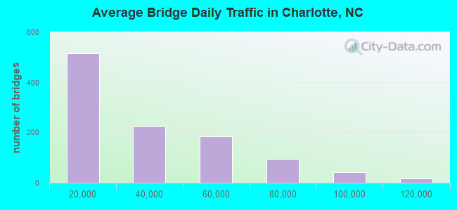
- 32,882,618Total average daily traffic
- 4,671,732Total average daily truck traffic
- National Bridge Inventory (NBI) Registered Bridges for Charlotte
- No street view available for this location
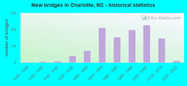
- New bridges - historical statistics
- 31920-1929
- 71930-1939
- 101940-1949
- 411950-1959
- 741960-1969
- 2131970-1979
- 1561980-1989
- 1981990-1999
- 2282000-2009
- 1482010-2019
- 122020-2022
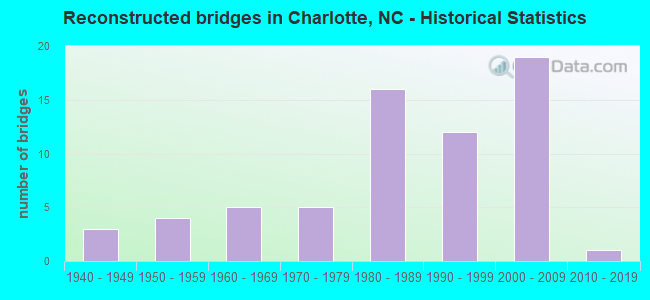
- Reconstructed bridges - Historical Statistics
- 31940-1949
- 41950-1959
- 51960-1969
- 51970-1979
- 161980-1989
- 121990-1999
- 192000-2009
- 12010-2019
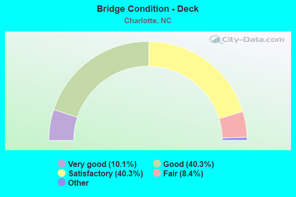
- Bridge Condition - Deck
- 10.1%Excellent
- 40.3%Very good
- 40.3%Good
- 8.4%Satisfactory
- 1.0%Fair
- 0.7%Poor
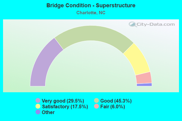
- Bridge Condition - Superstructure
- 29.5%Excellent
- 45.3%Very good
- 17.5%Good
- 6.0%Satisfactory
- 1.7%Fair
- 0.7%Poor
- 0.5%Serious
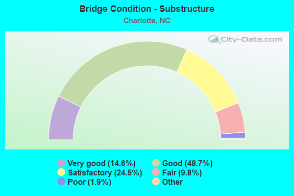
- Bridge Condition - Substructure
- 14.6%Excellent
- 48.7%Very good
- 24.5%Good
- 9.8%Satisfactory
- 1.9%Fair
- 0.5%Poor
- 0.2%Serious
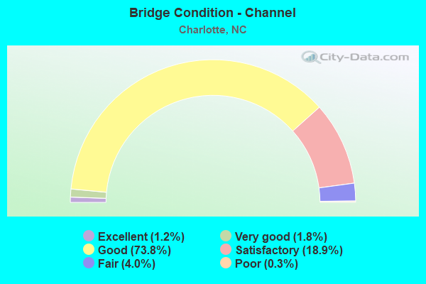
- Bridge Condition - Channel
- 1.2%Excellent
- 1.8%Very good
- 73.8%Good
- 18.9%Satisfactory
- 4.0%Fair
- 0.3%Poor
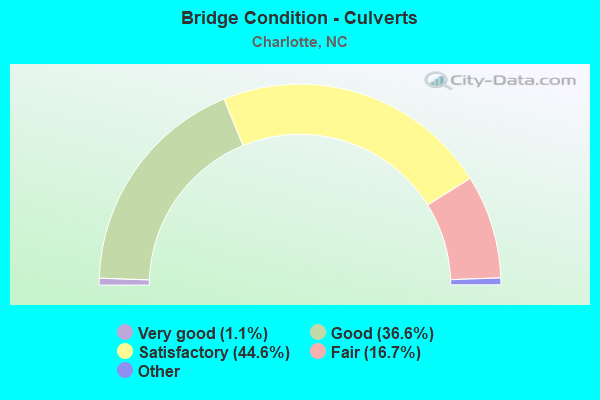
- Bridge Condition - Culverts
- 1.1%Excellent
- 36.6%Very good
- 44.6%Good
- 16.7%Satisfactory
- 1.1%Fair
- 0.5%Serious
Find on map >> Show street view
Structure Number: 1191229, Location: 1.2 MI. W. JCT. US29 (Lat: 35.346461, Lng: -80.735300), Route carried "under" structure: Ramp Interstate 85, Year Built: 2013, Structure Length: 0. m, Average Daily Traffic: 16,125 (year 2015), Truck Traffic: 16%, Features Intersected: I85 RAMP,I485 RAMP
Minimum Vertical Clearance: 7.70m (25.26ft), Kilometerpoint: 14.444, Lanes on structure: 2, Lanes under structure: 2, Material/Design: Prestressed concrete continuous, Design/Construction: Stringer/Multi-beam, Length of Maximum Span: 32.9m (107.9ft)
Find on map >> Show street view
Structure Number: 1191265, Location: 1.2 MI. E. JCT. NC 115 (Lat: 35.367542, Lng: -80.806069), Route carried "under" structure: Interstate 485, Year Built: 2012, Structure Length: 0. m, Average Daily Traffic: 25,500 (year 2011), Truck Traffic: 16%, Features Intersected: SR 2480
Minimum Vertical Clearance: 5.82m (19.09ft), Kilometerpoint: 0.000, Lanes on structure: 2, Lanes under structure: 4, Material/Design: Prestressed concrete continuous, Design/Construction: Stringer/Multi-beam, Length of Maximum Span: 32.9m (107.9ft)
Find on map >> Show street view
Structure Number: 1191265, Location: 1.2 MI. E. JCT. NC 115 (Lat: 35.367542, Lng: -80.806069), Route carried "under" structure: Interstate 485, Year Built: 2012, Structure Length: 0. m, Average Daily Traffic: 25,500 (year 2011), Truck Traffic: 16%, Features Intersected: SR 2480
Minimum Vertical Clearance: 6.44m (21.13ft), Kilometerpoint: 0.000, Lanes on structure: 2, Lanes under structure: 4, Material/Design: Prestressed concrete continuous, Design/Construction: Stringer/Multi-beam, Length of Maximum Span: 32.9m (107.9ft)
Find on map >> Show street view
Structure Number: 1191266, Location: 0.25 MI.S.JCT.SR2601 (Lat: 35.369092, Lng: -80.789492), Route carried "under" structure: Interstate 485, Year Built: 2015, Structure Length: 0. m, Average Daily Traffic: 28,000 (year 2015), Truck Traffic: 16%, Features Intersected: SR6050
Minimum Vertical Clearance: 5.81m (19.06ft), Kilometerpoint: 7.955, Lanes on structure: 2, Lanes under structure: 4, Material/Design: Prestressed concrete continuous, Design/Construction: Stringer/Multi-beam, Length of Maximum Span: 27.1m (88.9ft)
Find on map >> Show street view
Structure Number: 1191266, Location: 0.25 MI.S.JCT.SR2601 (Lat: 35.369092, Lng: -80.789492), Route carried "under" structure: Interstate 485, Year Built: 2015, Structure Length: 0. m, Average Daily Traffic: 28,000 (year 2015), Truck Traffic: 16%, Features Intersected: SR6050
Minimum Vertical Clearance: 5.51m (18.08ft), Kilometerpoint: 7.955, Lanes on structure: 2, Lanes under structure: 4, Material/Design: Prestressed concrete continuous, Design/Construction: Stringer/Multi-beam, Length of Maximum Span: 27.1m (88.9ft)
Find on map >> Show street view
Structure Number: 1191267, Location: 0.2 MI. N. JCT. SR2477 (Lat: 35.368883, Lng: -80.784403), Route carried "under" structure: Interstate 485, Year Built: 2013, Structure Length: 0. m, Average Daily Traffic: 50,000 (year 2019), Truck Traffic: 16%, Features Intersected: PROSPERITY CH. RD.
Minimum Vertical Clearance: 5.42m (17.78ft), Kilometerpoint: 8.016, Lanes on structure: 2, Lanes under structure: 4, Material/Design: Prestressed concrete continuous, Design/Construction: Stringer/Multi-beam, Length of Maximum Span: 27.1m (88.9ft)
Find on map >> Show street view
Structure Number: 1191267, Location: 0.2 MI. N. JCT. SR2477 (Lat: 35.368883, Lng: -80.784403), Route carried "under" structure: Interstate 485, Year Built: 2013, Structure Length: 0. m, Average Daily Traffic: 50,000 (year 2019), Truck Traffic: 16%, Features Intersected: PROSPERITY CH. RD.
Minimum Vertical Clearance: 5.69m (18.67ft), Kilometerpoint: 8.016, Lanes on structure: 2, Lanes under structure: 4, Material/Design: Prestressed concrete continuous, Design/Construction: Stringer/Multi-beam, Length of Maximum Span: 27.1m (88.9ft)
Find on map >> Show street view
Structure Number: 1191268, Location: 0.28 MI.S.JCT.SR2601 (Lat: 35.368775, Lng: -80.780000), Route carried "under" structure: Interstate 485, Year Built: 2015, Structure Length: 0. m, Average Daily Traffic: 28,000 (year 2015), Truck Traffic: 16%, Features Intersected: SR6052
Minimum Vertical Clearance: 5.51m (18.08ft), Kilometerpoint: 8.119, Lanes on structure: 2, Lanes under structure: 4, Material/Design: Prestressed concrete continuous, Design/Construction: Stringer/Multi-beam, Length of Maximum Span: 27.1m (88.9ft)
Find on map >> Show street view
Structure Number: 1191268, Location: 0.28 MI.S.JCT.SR2601 (Lat: 35.368775, Lng: -80.780000), Route carried "under" structure: Interstate 485, Year Built: 2015, Structure Length: 0. m, Average Daily Traffic: 28,000 (year 2015), Truck Traffic: 16%, Features Intersected: SR6052
Minimum Vertical Clearance: 5.87m (19.26ft), Kilometerpoint: 8.119, Lanes on structure: 2, Lanes under structure: 4, Material/Design: Prestressed concrete continuous, Design/Construction: Stringer/Multi-beam, Length of Maximum Span: 27.1m (88.9ft)
Find on map >> Show street view
Structure Number: 1191271, Location: 0.1 MI. S. JCT. SR2464 (Lat: 35.361944, Lng: -80.749389), Route carried "under" structure: Interstate 485, Year Built: 2013, Structure Length: 0. m, Average Daily Traffic: 26,000 (year 2013), Truck Traffic: 16%, Features Intersected: SR2467
Minimum Vertical Clearance: 5.85m (19.19ft), Kilometerpoint: 0.000, Lanes on structure: 2, Lanes under structure: 5, Material/Design: Prestressed concrete continuous, Design/Construction: Stringer/Multi-beam, Length of Maximum Span: 29.8m (97.8ft)
Find on map >> Show street view
Structure Number: 1191271, Location: 0.1 MI. S. JCT. SR2464 (Lat: 35.361944, Lng: -80.749389), Route carried "under" structure: Interstate 485, Year Built: 2013, Structure Length: 0. m, Average Daily Traffic: 26,000 (year 2013), Truck Traffic: 16%, Features Intersected: SR2467
Minimum Vertical Clearance: 5.47m (17.95ft), Kilometerpoint: 8.814, Lanes on structure: 2, Lanes under structure: 5, Material/Design: Prestressed concrete continuous, Design/Construction: Stringer/Multi-beam, Length of Maximum Span: 29.8m (97.8ft)
Find on map >> Show street view
Structure Number: 1191272, Location: 0.1 MI. E. JCT. SR2463 (Lat: 35.363250, Lng: -80.746861), Route carried "under" structure: State highway 2464, Year Built: 2013, Structure Length: 0. m, Average Daily Traffic: 6,750 (year 2014), Truck Traffic: 7%, Features Intersected: SR2601
Minimum Vertical Clearance: 5.76m (18.90ft), Kilometerpoint: 0.000, Lanes on structure: 2, Lanes under structure: 4, Material/Design: Prestressed concrete continuous, Design/Construction: Stringer/Multi-beam, Length of Maximum Span: 24.0m (78.7ft)
Find on map >> Show street view
Structure Number: 1191272, Location: 0.1 MI. E. JCT. SR2463 (Lat: 35.363250, Lng: -80.746861), Route carried "under" structure: State highway 2464, Year Built: 2013, Structure Length: 0. m, Average Daily Traffic: 6,750 (year 2014), Truck Traffic: 7%, Features Intersected: SR2601
Minimum Vertical Clearance: 6.17m (20.24ft), Kilometerpoint: 0.000, Lanes on structure: 2, Lanes under structure: 3, Material/Design: Prestressed concrete continuous, Design/Construction: Stringer/Multi-beam, Length of Maximum Span: 24.0m (78.7ft)
Find on map >> Show street view
Structure Number: 1191317, Location: .5MI.E.JCT.US29(TRYON ST) (Lat: 35.251861, Lng: -80.791333), Route carried "under" structure: City street , Year Built: 2019, Structure Length: 0. m, Average Daily Traffic: 8,500 (year 2014), Truck Traffic: 7%, Features Intersected: SR2975SR2975, Facility Carried by Structure: RALEIGH ST.
Minimum Vertical Clearance: 5.51m (18.08ft), Kilometerpoint: 0.000, Lanes on structure: 4, Lanes under structure: 2, Material/Design: Prestressed concrete continuous, Design/Construction: Stringer/Multi-beam, Length of Maximum Span: 38.7m (127.0ft)
Find on map >> Show street view
Structure Number: 1191317, Location: .5MI.E.JCT.US29(TRYON ST) (Lat: 35.251861, Lng: -80.791333), Route carried "under" structure: City street , Year Built: 2019, Structure Length: 0. m, Average Daily Traffic: 8,500 (year 2014), Truck Traffic: 7%, Features Intersected: SR2975SR2975, Facility Carried by Structure: BEARWOOD AVE.
Minimum Vertical Clearance: 5.02m (16.47ft), Kilometerpoint: 0.000, Lanes on structure: 4, Lanes under structure: 2, Material/Design: Prestressed concrete continuous, Design/Construction: Stringer/Multi-beam, Length of Maximum Span: 38.7m (127.0ft)
Find on map >> Show street view
Structure Number: 1191319, Location: .3 MI.N.JCT.BALLANTYNE CM (Lat: 35.063611, Lng: -80.848611), Route carried "under" structure: US 521, Year Built: 2014, Structure Length: 0. m, Average Daily Traffic: 25,500 (year 2012), Truck Traffic: 6%, Features Intersected: I485 WBL RAMP
Minimum Vertical Clearance: 6.93m (22.74ft), Kilometerpoint: 0.000, Lanes on structure: 1, Lanes under structure: 2, Material/Design: Prestressed concrete, Design/Construction: Stringer/Multi-beam, Length of Maximum Span: 39.3m (128.9ft)
Find on map >> Show street view
Structure Number: 1191319, Location: .3 MI.N.JCT.BALLANTYNE CM (Lat: 35.063611, Lng: -80.848611), Route carried "under" structure: Interstate 485, Year Built: 2014, Structure Length: 0. m, Average Daily Traffic: 43,250 (year 2013), Truck Traffic: 16%, Features Intersected: I485 WBL RAMP
Minimum Vertical Clearance: 9.06m (29.72ft), Kilometerpoint: 18.727, Lanes on structure: 1, Lanes under structure: 3, Material/Design: Prestressed concrete, Design/Construction: Stringer/Multi-beam, Length of Maximum Span: 39.3m (128.9ft)
Find on map >> Show street view
Structure Number: 1191319, Location: .3 MI.N.JCT.BALLANTYNE CM (Lat: 35.063611, Lng: -80.848611), Route carried "under" structure: Interstate 485, Year Built: 2014, Structure Length: 0. m, Average Daily Traffic: 43,250 (year 2013), Truck Traffic: 16%, Features Intersected: I485 WBL RAMP
Minimum Vertical Clearance: 7.31m (23.98ft), Kilometerpoint: 18.727, Lanes on structure: 1, Lanes under structure: 2, Material/Design: Prestressed concrete, Design/Construction: Stringer/Multi-beam, Length of Maximum Span: 39.3m (128.9ft)
Find on map >> Show street view
Structure Number: 1191319, Location: .3 MI.N.JCT.BALLANTYNE CM (Lat: 35.063611, Lng: -80.848611), Route carried "under" structure: US 521, Year Built: 2014, Structure Length: 0. m, Average Daily Traffic: 25,500 (year 2012), Truck Traffic: 6%, Features Intersected: I485 WBL RAMP
Minimum Vertical Clearance: 5.76m (18.90ft), Kilometerpoint: 0.000, Lanes on structure: 1, Lanes under structure: 3, Material/Design: Prestressed concrete, Design/Construction: Stringer/Multi-beam, Length of Maximum Span: 39.3m (128.9ft)
Find on map >> Show street view
Structure Number: 1191326, Location: 0.09 MI. S,JCT.I85 (Lat: 35.347111, Lng: -80.732694), Route carried "under" structure: Interstate 85, Year Built: 2015, Structure Length: 0. m, Average Daily Traffic: 500 (year 2015), Truck Traffic: 14%, Features Intersected: I-485E OUTER LOOP
Minimum Vertical Clearance: 6.30m (20.67ft), Kilometerpoint: 0.000, Lanes on structure: 3, Lanes under structure: 2, Material/Design: Prestressed concrete, Design/Construction: Stringer/Multi-beam, Length of Maximum Span: 34.7m (113.8ft)
Find on map >> Show street view
Structure Number: 1191327, Location: 0.10 MI S. JCT. I-85 (Lat: 35.347214, Lng: -80.732361), Route carried "under" structure: Ramp Interstate 85, Year Built: 2015, Structure Length: 0. m, Average Daily Traffic: 5,000 (year 2014), Truck Traffic: 16%, Features Intersected: I-485W OUTER LOOP
Minimum Vertical Clearance: 5.81m (19.06ft), Kilometerpoint: 0.000, Lanes on structure: 3, Lanes under structure: 2, Material/Design: Prestressed concrete, Design/Construction: Stringer/Multi-beam, Length of Maximum Span: 34.7m (113.8ft)
Find on map >> Show street view
Structure Number: 1191328, Location: 1.2 MI. E. JCT. SR2467 (Lat: 35.346131, Lng: -80.732014), Route carried "under" structure: Ramp Interstate 485, Year Built: 2015, Structure Length: 0. m, Average Daily Traffic: 5,000 (year 2014), Truck Traffic: 16%, Features Intersected: I485 INNER
Minimum Vertical Clearance: 5.99m (19.65ft), Kilometerpoint: 0.000, Lanes on structure: 3, Lanes under structure: 2, Material/Design: Prestressed concrete, Design/Construction: Stringer/Multi-beam, Length of Maximum Span: 35.3m (115.8ft)
Find on map >> Show street view
Structure Number: 1191329, Location: 0.10 MI. S. JCT. I-85 (Lat: 35.346389, Lng: -80.731667), Route carried "under" structure: Ramp Interstate 85, Year Built: 2015, Structure Length: 0. m, Average Daily Traffic: 5,000 (year 2014), Truck Traffic: 16%, Features Intersected: I-485W OUTER LOOP
Minimum Vertical Clearance: 6.04m (19.82ft), Kilometerpoint: 0.000, Lanes on structure: 3, Lanes under structure: 2, Material/Design: Prestressed concrete, Design/Construction: Stringer/Multi-beam, Length of Maximum Span: 35.3m (115.8ft)
Find on map >> Show street view
Structure Number: 1191338, Location: I-277 ramp flyover from I (Lat: 35.244861, Lng: -80.846278), Route carried "under" structure: Interstate 77, Year Built: 2019, Structure Length: 0. m, Average Daily Traffic: 85,500 (year 2018), Truck Traffic: 16%, Features Intersected: Ramp I-277 To I-77 NB H
Minimum Vertical Clearance: 8.22m (26.97ft), Kilometerpoint: 1.524, Lanes on structure: 1, Lanes under structure: 4, Material/Design: Prestressed concrete, Design/Construction: Stringer/Multi-beam, Length of Maximum Span: 35.3m (115.8ft)
Find on map >> Show street view
Structure Number: 1191339, Location: I-77 between Lasalle St. (Lat: 35.267583, Lng: -80.844911), Route carried "under" structure: Interstate 77, Year Built: 2019, Structure Length: 0. m, Average Daily Traffic: 80,000 (year 2018), Truck Traffic: 16%, Features Intersected: I-77 Northbound Hot Lane
Minimum Vertical Clearance: 6.29m (20.64ft), Kilometerpoint: 3.962, Lanes on structure: 2, Lanes under structure: 3, Material/Design: Prestressed concrete, Design/Construction: Stringer/Multi-beam, Length of Maximum Span: 35.6m (116.8ft)
Find on map >> Show street view
Structure Number: 119134, Location: I-77 between Lasalle St. (Lat: 35.273281, Lng: -80.843722), Route carried "under" structure: Interstate 85, Year Built: 2019, Structure Length: 0. m, Average Daily Traffic: 83,000 (year 2018), Truck Traffic: 16%, Features Intersected: I-77 NB Hot Lanes
Minimum Vertical Clearance: 6.42m (21.06ft), Kilometerpoint: 0.000, Lanes on structure: 2, Lanes under structure: 5, Material/Design: Prestressed concrete, Design/Construction: Stringer/Multi-beam, Length of Maximum Span: 36.5m (119.8ft)
Find on map >> Show street view
Structure Number: 119134, Location: I-77 between Lasalle St. (Lat: 35.273281, Lng: -80.843722), Route carried "under" structure: Interstate 85, Year Built: 2019, Structure Length: 0. m, Average Daily Traffic: 83,000 (year 2018), Truck Traffic: 16%, Features Intersected: I-77 NB Hot Lanes
Minimum Vertical Clearance: 5.96m (19.55ft), Kilometerpoint: 0.000, Lanes on structure: 2, Lanes under structure: 4, Material/Design: Prestressed concrete, Design/Construction: Stringer/Multi-beam, Length of Maximum Span: 36.5m (119.8ft)
Find on map >> Show street view
Structure Number: 1191341, Location: I-77 between I-85 and I-7 (Lat: 35.276003, Lng: -80.843986), Route carried "under" structure: Interstate 85, Year Built: 2019, Structure Length: 0. m, Average Daily Traffic: 63,500 (year 2018), Truck Traffic: 16%, Features Intersected: I-77 NB Hot Lanes
Minimum Vertical Clearance: 5.94m (19.49ft), Kilometerpoint: 4.114, Lanes on structure: 2, Lanes under structure: 2, Material/Design: Prestressed concrete, Design/Construction: Stringer/Multi-beam, Length of Maximum Span: 27.1m (88.9ft)
Find on map >> Show street view
Structure Number: 1191342, Location: I77NB BW. I85 & CINDY LN. (Lat: 35.278056, Lng: -80.845278), Route carried "under" structure: Interstate 77, Year Built: 2019, Structure Length: 0. m, Average Daily Traffic: 57,000 (year 2019), Truck Traffic: 6%, Features Intersected: I-77 NB
Minimum Vertical Clearance: 5.18m (16.99ft), Kilometerpoint: 0.000, Lanes on structure: 3, Lanes under structure: 2, Material/Design: Concrete, Design/Construction: Culvert, Length of Maximum Span: 12.8m (42.0ft)
Find on map >> Show street view
Structure Number: 1191344, Location: I-77 between Lasalle St. (Lat: 35.273056, Lng: -80.844444), Route carried "under" structure: Interstate 85, Year Built: 2019, Structure Length: 0. m, Average Daily Traffic: 63,500 (year 2018), Truck Traffic: 16%, Features Intersected: Ramp to I-77 SB Hot Lane
Minimum Vertical Clearance: 7.75m (25.43ft), Kilometerpoint: 0.000, Lanes on structure: 1, Lanes under structure: 5, Material/Design: Prestressed concrete, Design/Construction: Stringer/Multi-beam, Length of Maximum Span: 37.1m (121.7ft)
Find on map >> Show street view
Structure Number: 1191344, Location: I-77 between Lasalle St. (Lat: 35.273056, Lng: -80.844444), Route carried "under" structure: Interstate 85, Year Built: 2019, Structure Length: 0. m, Average Daily Traffic: 63,500 (year 2018), Truck Traffic: 16%, Features Intersected: Ramp to I-77 SB Hot Lane
Minimum Vertical Clearance: 6.50m (21.33ft), Kilometerpoint: 0.000, Lanes on structure: 1, Lanes under structure: 4, Material/Design: Prestressed concrete, Design/Construction: Stringer/Multi-beam, Length of Maximum Span: 37.1m (121.7ft)
Find on map >> Show street view
Structure Number: 1191357, Location: 0.5 MI.W.OF NC 29 (Lat: 35.298333, Lng: -80.763611), Route carried "under" structure: Interstate 85, Year Built: 2017, Structure Length: 0. m, Average Daily Traffic: 72,000 (year 2019), Truck Traffic: 16%, Features Intersected: UNIV.POINTE BLVD
Minimum Vertical Clearance: 6.32m (20.73ft), Kilometerpoint: 6.522, Lanes on structure: 2, Lanes under structure: 5, Material/Design: Prestressed concrete continuous, Design/Construction: Stringer/Multi-beam, Length of Maximum Span: 37.7m (123.7ft)
Find on map >> Show street view
Structure Number: 1191357, Location: 0.5 MI.W.OF NC 29 (Lat: 35.298333, Lng: -80.763611), Route carried "under" structure: Interstate 85, Year Built: 2017, Structure Length: 0. m, Average Daily Traffic: 72,000 (year 2019), Truck Traffic: 16%, Features Intersected: UNIV.POINTE BLVD
Minimum Vertical Clearance: 5.63m (18.47ft), Kilometerpoint: 6.522, Lanes on structure: 2, Lanes under structure: 5, Material/Design: Prestressed concrete continuous, Design/Construction: Stringer/Multi-beam, Length of Maximum Span: 37.7m (123.7ft)
Find on map >> Show street view
Structure Number: 11914, Location: 1.2 MI. E. JCT.SR2467 (Lat: 35.348906, Lng: -80.735556), Route carried "under" structure: Ramp Interstate 85, Year Built: 2015, Structure Length: 0. m, Average Daily Traffic: 38,000 (year 2018), Truck Traffic: 16%, Features Intersected: I485 INNER RAMP
Minimum Vertical Clearance: 5.82m (19.09ft), Kilometerpoint: 0.000, Lanes on structure: 2, Lanes under structure: 2, Material/Design: Prestressed concrete, Design/Construction: Stringer/Multi-beam, Length of Maximum Span: 38.7m (127.0ft)
Find on map >> Show street view
Structure Number: 1191401, Location: 1.4MI. E. JCT.SR2467 (Lat: 35.346967, Lng: -80.734819), Route carried "under" structure: Interstate 85, Year Built: 2015, Structure Length: 0. m, Average Daily Traffic: 500 (year 2015), Truck Traffic: 14%, Features Intersected: I485 INNER RAMP
Minimum Vertical Clearance: 5.77m (18.93ft), Kilometerpoint: 0.000, Lanes on structure: 2, Lanes under structure: 2, Toll: Toll bridge is a segment, Material/Design: Prestressed concrete, Design/Construction: Stringer/Multi-beam, Length of Maximum Span: 33.5m (109.9ft)
Find on map >> Show street view
Structure Number: 1191401, Location: 1.4MI. E. JCT.SR2467 (Lat: 35.346967, Lng: -80.734819), Route carried "under" structure: Interstate 85, Year Built: 2015, Structure Length: 0. m, Average Daily Traffic: 104,600 (year 2008), Truck Traffic: 15%, Features Intersected: I485 INNER RAMP
Minimum Vertical Clearance: 7.01m (23.00ft), Kilometerpoint: 14.447, Lanes on structure: 2, Lanes under structure: 3, Toll: Toll bridge is a segment, Material/Design: Prestressed concrete, Design/Construction: Stringer/Multi-beam, Length of Maximum Span: 33.5m (109.9ft)
Find on map >> Show street view
Structure Number: 1191401, Location: 1.4MI. E. JCT.SR2467 (Lat: 35.346967, Lng: -80.734819), Route carried "under" structure: Interstate 85, Year Built: 2015, Structure Length: 0. m, Average Daily Traffic: 104,600 (year 2008), Truck Traffic: 15%, Features Intersected: I485 INNER RAMP
Minimum Vertical Clearance: 5.36m (17.59ft), Kilometerpoint: 14.447, Lanes on structure: 2, Lanes under structure: 3, Toll: Toll bridge is a segment, Material/Design: Prestressed concrete, Design/Construction: Stringer/Multi-beam, Length of Maximum Span: 33.5m (109.9ft)
Find on map >> Show street view
Structure Number: 1191408, Location: 0.6M. E. JCT.OLD DOWNS RD (Lat: 35.220981, Lng: -80.943947), Route carried "under" structure: City street , Year Built: 2015, Structure Length: 0. m, Average Daily Traffic: 26,000 (year 2016), Truck Traffic: 7%, Features Intersected: JOSH BIRMINGHAM, Facility Carried by Structure: AIRPORT LOOP RD.
Minimum Vertical Clearance: 4.26m (13.98ft), Kilometerpoint: 0.000, Lanes on structure: 2, Lanes under structure: 5, Material/Design: Prestressed concrete continuous, Design/Construction: Stringer/Multi-beam, Length of Maximum Span: 14.0m (45.9ft)
Find on map >> Show street view
Structure Number: 119141, Location: .27M.S.JCT.WILKINSON BLVD (Lat: 35.231428, Lng: -80.940211), Route carried "under" structure: City street , Year Built: 2019, Structure Length: 0. m, Average Daily Traffic: 14,000 (year 2012), Truck Traffic: 7%, Features Intersected: N.JOSH BIRMINGHAM, Facility Carried by Structure: RC JOSH BIRMINGHAM
Minimum Vertical Clearance: 4.82m (15.81ft), Kilometerpoint: 0.000, Lanes on structure: 2, Lanes under structure: 1, Material/Design: Prestressed concrete, Design/Construction: Stringer/Multi-beam, Length of Maximum Span: 13.7m (44.9ft)
Find on map >> Show street view
Structure Number: 1191411, Location: 0.35M. W. JCT.HARLEE AVE. (Lat: 35.233167, Lng: -80.939583), Route carried "under" structure: City street , Year Built: 2019, Structure Length: 0. m, Average Daily Traffic: 26,000 (year 2016), Truck Traffic: 7%, Features Intersected: RCJOSH BIRMINGHAM, Facility Carried by Structure: N.JOSH BIRMINGHAM
Minimum Vertical Clearance: 5.91m (19.39ft), Kilometerpoint: 0.000, Lanes on structure: 2, Lanes under structure: 3, Material/Design: Prestressed concrete, Design/Construction: Stringer/Multi-beam, Length of Maximum Span: 28.0m (91.9ft)