Bridge Statistics for Chattanooga, Tennessee (TN)
Condition, Traffic, Stress, Structural Evaluation, Project Costs
- National Bridge Inventory (NBI) Statistics
- 480Number of bridges
- 6,263ft / 1,909mTotal length
- $388,242,000Total costs
- 14,792,925Total average daily traffic
- 2,458,039Total average daily truck traffic
- National Bridge Inventory (NBI) Registered Bridges for Chattanooga
- No street view available for this location
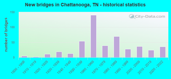
- New bridges - historical statistics
- 1Before 1900
- 51900-1909
- 31910-1919
- 111920-1929
- 191930-1939
- 131940-1949
- 541950-1959
- 1401960-1969
- 391970-1979
- 701980-1989
- 281990-1999
- 372000-2009
- 242010-2019
- 362020-2022

- Reconstructed bridges - Historical Statistics
- 31940-1949
- 01950-1959
- 01960-1969
- 71970-1979
- 161980-1989
- 311990-1999
- 12000-2009


- Bridge Condition - Deck
- 5.7%Very good
- 59.6%Good
- 25.7%Satisfactory
- 7.0%Fair
- 1.7%Poor
- 0.4%Serious

- Bridge Condition - Superstructure
- 11.7%Very good
- 34.8%Good
- 39.1%Satisfactory
- 10.9%Fair
- 2.6%Poor
- 0.9%Serious
- 0.4%Critical

- Bridge Condition - Substructure
- 3.9%Very good
- 58.3%Good
- 23.5%Satisfactory
- 10.0%Fair
- 4.3%Poor

- Bridge Condition - Channel
- 7.9%Very good
- 42.1%Good
- 38.6%Satisfactory
- 10.0%Fair
- 1.4%Poor

- Bridge Condition - Culverts
- 80.6%Good
- 15.3%Satisfactory
- 2.8%Fair
- 1.4%Serious
Find on map >> Show street view
Structure Number: 33M36090001, Location: 0.1 MI S OF I-24 JCT. (Lat: 35.002883, Lng: -85.219100), Route carried "on" structure: City street 3609, Year Built: 1959, Status: Open, Structure Length: 2.61m (8.56ft), Average Daily Traffic: 9,346 (year 2020), Truck Traffic: 4%, Average Future Daily Traffic: 19,680 (year 2039), Design Load: HS 20, Features Intersected: SPRING CREEK
Minimum Vertical Clearance: 30+ m (98+ ft), Kilometerpoint: 1.625, Lanes on structure: 4, Owner: City or Municipal Highway Agency, Approaching Roadway Width: 15.8m (51.8ft), Skew: 20 degrees, Material/Design: Prestressed concrete, Design/Construction: Box Beam or Girders - Multiple, Number Of Spans In Main Unit: 3, Length of Maximum Span: 8.1m (26.6ft), Curb or Sidewalk Widths: Left: 1.2m (3.9ft), Right: 1.2m (3.9ft), Curb-To-Curb Width: 15.8m (51.8ft), Out-to-Out Width: 22.7m (74.5ft)
Condition: Deck: Satisfactory, Superstructure: Satisfactory, Substructure: Satisfactory, Channel: Satisfactory, Operating Rating: 89.1 metric tons, Method Used To Determine Operating Rating: Load Factor (LF), Inventory Rating: 32.4 metric tons, Method Used To Determine Inventory Rating: Load Factor (LF), Structural Evaluation: Equal to present minimum criteria, Deck Geometry: Meets minimum limits, Waterway Adequacy: Superior to present desirable criteria, Approach Roadway Alignment: Equal to present desirable criteria, Length Of Structure Improvement: 2.61m (8.56ft), Designated Inspection Frequency: Every 24 months, Inspection Date: June 2021, Bridge Improvement Cost: $90,000, Roadway Improvement Cost: $10,000, Total Project Cost: $136,000 ( Estimate for 2019), Deck Structure Type: Other, Wearing Surface/Protective System: Wearing Surface: Bituminous
Find on map >> Show street view
Structure Number: 33M36100001, Location: IN EAST RIDGE (Lat: 35.001567, Lng: -85.230167), Route carried "on" structure: City street 3610, Year Built: 2001, Status: Open, Structure Length: 1.19m (3.90ft), Average Daily Traffic: 7,735 (year 2020), Truck Traffic: 4%, Average Future Daily Traffic: 14,176 (year 2039), Design Load: HS 20, Features Intersected: SMALL STREAM
Minimum Vertical Clearance: 30+ m (98+ ft), Kilometerpoint: 2.076, Lanes on structure: 2, Owner: City or Municipal Highway Agency, Approaching Roadway Width: 7.3m (24.0ft), Material/Design: Prestressed concrete, Design/Construction: Stringer/Multi-beam, Number Of Spans In Main Unit: 1, Length of Maximum Span: 11.4m (37.4ft), Curb-To-Curb Width: 12.2m (40.0ft), Out-to-Out Width: 13.4m (44.0ft)
Condition: Deck: Good, Superstructure: Good, Substructure: Good, Channel: Good, Operating Rating: 89.1 metric tons, Method Used To Determine Operating Rating: Load Factor (LF), Inventory Rating: 32.4 metric tons, Method Used To Determine Inventory Rating: Load Factor (LF), Structural Evaluation: Better than present minimum criteria, Deck Geometry: Somewhat better than minimum adequacy, Waterway Adequacy: Equal to present minimum criteria, Approach Roadway Alignment: Equal to present desirable criteria, Designated Inspection Frequency: Every 24 months, Inspection Date: May 2021, Deck Structure Type: Other, Wearing Surface/Protective System: Wearing Surface: Bituminous
Find on map >> Show street view
Structure Number: 33M36140001, Location: 1 MI.EAST OF LOOKOUT MTN. (Lat: 34.994583, Lng: -85.303117), Route carried "on" structure: City street 3614, Year Built: 1974, Status: Open, Structure Length: 5.18m (16.99ft), Average Daily Traffic: 5,591 (year 2020), Truck Traffic: 4%, Average Future Daily Traffic: 8,946 (year 2042), Design Load: H 20, Features Intersected: CHATTANOOGA CREEK
Minimum Vertical Clearance: 30+ m (98+ ft), Kilometerpoint: 1.947, Lanes on structure: 2, Owner: City or Municipal Highway Agency, Approaching Roadway Width: 9.8m (32.2ft), Material/Design: Concrete, Design/Construction: Tee Beam, Number Of Spans In Main Unit: 5, Length of Maximum Span: 10.4m (34.1ft), Curb-To-Curb Width: 9.1m (29.9ft), Out-to-Out Width: 10.6m (34.8ft)
Condition: Deck: Satisfactory, Superstructure: Fair, Substructure: Fair, Channel: Satisfactory, Operating Rating: 45.9 metric tons, Method Used To Determine Operating Rating: Load Factor (LF), Inventory Rating: 27.9 metric tons, Method Used To Determine Inventory Rating: Load Factor (LF), Structural Evaluation: Somewhat better than minimum adequacy, Deck Geometry: High priority of corrective action, Waterway Adequacy: Better than present minimum criteria, Approach Roadway Alignment: Equal to present desirable criteria, Length Of Structure Improvement: 5.18m (16.99ft), Designated Inspection Frequency: Every 24 months, Inspection Date: May 2021, Bridge Improvement Cost: $418,000, Roadway Improvement Cost: $42,000, Total Project Cost: $628,000 ( Estimate for 2022), Deck Structure Type: Concrete Cast-file-Place, Wearing Surface/Protective System: Wearing Surface: Monolithic Concrete
Find on map >> Show street view
Structure Number: 33M36150001, Location: 0.1 MI OF GA TN ST LI (Lat: 34.985183, Lng: -85.310517), Route carried "on" structure: City street 3615, Year Built: 1962, Status: Posted for load, Structure Length: 5.18m (16.99ft), Average Daily Traffic: 5,127 (year 2020), Truck Traffic: 4%, Average Future Daily Traffic: 8,203 (year 2041), Design Load: H 20, Features Intersected: CHATTANOOGA CREEK
Minimum Vertical Clearance: 30+ m (98+ ft), Kilometerpoint: 1.271, Lanes on structure: 2, Owner: City or Municipal Highway Agency, Approaching Roadway Width: 7.9m (25.9ft), Material/Design: Concrete, Design/Construction: Tee Beam, Number Of Spans In Main Unit: 5, Length of Maximum Span: 10.4m (34.1ft), Curb-To-Curb Width: 8.6m (28.2ft), Out-to-Out Width: 10.1m (33.1ft)
Condition: Deck: Satisfactory, Superstructure: Fair, Substructure: Poor, Channel: Fair, Operating Rating: 32.4 metric tons, Method Used To Determine Operating Rating: Field evaluation and documented engineering judgment, Inventory Rating: 24.3 metric tons, Method Used To Determine Inventory Rating: Field evaluation and documented engineering judgment, Structural Evaluation: Meets minimum limits, Deck Geometry: High priority of replacement, Waterway Adequacy: Better than present minimum criteria, Approach Roadway Alignment: Equal to present desirable criteria, Length Of Structure Improvement: 5.18m (16.99ft), Designated Inspection Frequency: Every 24 months, Underwater Inspection Frequency: Every 60 months, Inspection Date: May 2021, Underwater Inspection Date: September 2019, Bridge Improvement Cost: $466,000, Roadway Improvement Cost: $47,000, Total Project Cost: $700,000 ( Estimate for 2021), Deck Structure Type: Concrete Cast-file-Place, Wearing Surface/Protective System: Wearing Surface: Monolithic Concrete
Find on map >> Show street view
Structure Number: 33S43060001, Location: IN RED BANK (Lat: 35.094483, Lng: -85.307067), Route carried "on" structure: City street 3596, Year Built: 1986, Status: Open, Structure Length: 0.79m (2.59ft), Average Daily Traffic: 4,663 (year 2020), Truck Traffic: 4%, Average Future Daily Traffic: 8,768 (year 2039), Design Load: HS 20, Features Intersected: STRINGERS BRANCH
Minimum Vertical Clearance: 30+ m (98+ ft), Kilometerpoint: 0.032, Lanes on structure: 3, Owner: City or Municipal Highway Agency, Approaching Roadway Width: 10.1m (33.1ft), Material/Design: Concrete continuous, Design/Construction: Culvert, Number Of Spans In Main Unit: 2, Length of Maximum Span: 3.7m (12.1ft), Curb or Sidewalk Widths: Left: 2.3m (7.5ft), Right: 0.0m, Curb-To-Curb Width: 11.3m (37.1ft), Out-to-Out Width: 15.2m (49.9ft)
Condition: Channel: Satisfactory, Culverts: Good, Operating Rating: 60.3 metric tons, Method Used To Determine Operating Rating: Load Factor (LF), Inventory Rating: 32.4 metric tons, Method Used To Determine Inventory Rating: Load Factor (LF), Structural Evaluation: Better than present minimum criteria, Deck Geometry: High priority of replacement, Waterway Adequacy: Equal to present desirable criteria, Approach Roadway Alignment: Equal to present desirable criteria, Length Of Structure Improvement: 0.79m (2.59ft), Designated Inspection Frequency: Every 24 months, Inspection Date: May 2021, Bridge Improvement Cost: $69,000, Roadway Improvement Cost: $7,000, Total Project Cost: $104,000 ( Estimate for 2019), Deck Structure Type: Concrete Cast-file-Place, Wearing Surface/Protective System: Wearing Surface: Bituminous
Find on map >> Show street view
Structure Number: 33S43060005, Location: 7.61 MI. E OF SR-153 JCT. (Lat: 35.200933, Lng: -85.157583), Route carried "on" structure: State highway 319, Year Built: 1985, Year Reconstructed: 2003, Status: Open, Structure Length: 1.16m (3.81ft), Average Daily Traffic: 17,108 (year 2020), Truck Traffic: 9%, Average Future Daily Traffic: 27,373 (year 2042), Design Load: HS 20, Features Intersected: BRANCH
Minimum Vertical Clearance: 30+ m (98+ ft), Kilometerpoint: 19.264, Lanes on structure: 2, Base Highway Network: Yes, Owner: State Highway Agency, Approaching Roadway Width: 9.1m (29.9ft), Skew: 3 degrees, Material/Design: Concrete continuous, Design/Construction: Culvert, Number Of Spans In Main Unit: 3, Length of Maximum Span: 3.0m (9.8ft), Curb-To-Curb Width: 12.3m (40.4ft), Out-to-Out Width: 13.4m (44.0ft)
Condition: Channel: Satisfactory, Culverts: Good, Operating Rating: 68.4 metric tons, Method Used To Determine Operating Rating: Load Factor (LF), Inventory Rating: 32.4 metric tons, Method Used To Determine Inventory Rating: Load Factor (LF), Structural Evaluation: Better than present minimum criteria, Deck Geometry: Somewhat better than minimum adequacy, Waterway Adequacy: Equal to present desirable criteria, Approach Roadway Alignment: Equal to present desirable criteria, Designated Inspection Frequency: Every 24 months, Inspection Date: April 2021, Deck Structure Type: Concrete Cast-file-Place, Wearing Surface/Protective System: Wearing Surface: Bituminous
Find on map >> Show street view
Structure Number: 33S43060007, Location: 7.94 MI. E OF SR-153 JCT. (Lat: 35.202917, Lng: -85.152550), Route carried "on" structure: State highway 319, Year Built: 1985, Year Reconstructed: 2003, Status: Open, Structure Length: 0.67m (2.20ft), Average Daily Traffic: 6,931 (year 2020), Truck Traffic: 9%, Average Future Daily Traffic: 11,090 (year 2042), Design Load: HS 20, Features Intersected: BRANCH
Minimum Vertical Clearance: 30+ m (98+ ft), Kilometerpoint: 19.795, Lanes on structure: 3, Base Highway Network: Yes, Owner: State Highway Agency, Approaching Roadway Width: 9.1m (29.9ft), Material/Design: Concrete continuous, Design/Construction: Culvert, Number Of Spans In Main Unit: 2, Length of Maximum Span: 3.0m (9.8ft), Curb-To-Curb Width: 16.3m (53.5ft), Out-to-Out Width: 17.2m (56.4ft)
Condition: Channel: Satisfactory, Culverts: Good, Operating Rating: 89.1 metric tons, Method Used To Determine Operating Rating: Load Factor (LF), Inventory Rating: 32.4 metric tons, Method Used To Determine Inventory Rating: Load Factor (LF), Structural Evaluation: Better than present minimum criteria, Deck Geometry: Better than present minimum criteria, Waterway Adequacy: Better than present minimum criteria, Approach Roadway Alignment: Equal to present desirable criteria, Designated Inspection Frequency: Every 24 months, Inspection Date: April 2021, Deck Structure Type: Concrete Precast Panels, Wearing Surface/Protective System: Wearing Surface: Bituminous
Find on map >> Show street view
Structure Number: 33S43060009, Location: 0.84 MI. E OF SR-153 JCT. (Lat: 35.139450, Lng: -85.233983), Route carried "on" structure: State highway 319, Year Built: 1936, Year Reconstructed: 1988, Status: Open, Structure Length: 4.82m (15.81ft), Average Daily Traffic: 23,556 (year 2020), Truck Traffic: 9%, Average Future Daily Traffic: 37,690 (year 2042), Design Load: HS 20, Features Intersected: SOUTHERN RAILWAY
Minimum Vertical Clearance: 30+ m (98+ ft), Kilometerpoint: 8.353, Lanes on structure: 5, Base Highway Network: Yes, Owner: State Highway Agency, Approaching Roadway Width: 18.3m (60.0ft), Skew: 3 degrees, Material/Design: Concrete, Design/Construction: Tee Beam, Number Of Spans In Main Unit: 5, Length of Maximum Span: 13.4m (44.0ft), Curb or Sidewalk Widths: Left: 1.5m (4.9ft), Right: 1.5m (4.9ft), Curb-To-Curb Width: 19.5m (64.0ft), Out-to-Out Width: 23.2m (76.1ft)
Condition: Deck: Satisfactory, Superstructure: Satisfactory, Substructure: Satisfactory, Operating Rating: 39.6 metric tons, Method Used To Determine Operating Rating: Load Factor (LF), Inventory Rating: 23.4 metric tons, Method Used To Determine Inventory Rating: Load Factor (LF), Structural Evaluation: Somewhat better than minimum adequacy, Deck Geometry: Meets minimum limits, Underclear: High priority of corrective action, Approach Roadway Alignment: Equal to present desirable criteria, Length Of Structure Improvement: 4.82m (15.81ft), Designated Inspection Frequency: Every 24 months, Inspection Date: April 2021, Bridge Improvement Cost: $1,775,000, Roadway Improvement Cost: $178,000, Total Project Cost: $2,663,000 ( Estimate for 2022), Deck Structure Type: Concrete Precast Panels, Wearing Surface/Protective System: Wearing Surface: Monolithic Concrete, Deck Protection: Epoxy Coated Reinforcing
Find on map >> Show street view
Structure Number: 33S43060011, Location: 1.94 MI. E OF SR-153 JCT. (Lat: 35.149100, Lng: -85.219100), Route carried "on" structure: State highway 319, Year Built: 1955, Year Reconstructed: 1990, Status: Open, Structure Length: 8.32m (27.30ft), Average Daily Traffic: 23,556 (year 2020), Truck Traffic: 9%, Average Future Daily Traffic: 37,690 (year 2042), Design Load: HS 20, Features Intersected: NORTH CHICKAMAUGA CREEK
Minimum Vertical Clearance: 30+ m (98+ ft), Kilometerpoint: 10.123, Lanes on structure: 5, Base Highway Network: Yes, Owner: State Highway Agency, Approaching Roadway Width: 15.8m (51.8ft), Skew: 3 degrees, Material/Design: Concrete, Design/Construction: Tee Beam, Number Of Spans In Main Unit: 7, Length of Maximum Span: 16.2m (53.1ft), Curb or Sidewalk Widths: Left: 1.5m (4.9ft), Right: 1.5m (4.9ft), Curb-To-Curb Width: 19.5m (64.0ft), Out-to-Out Width: 23.2m (76.1ft)
Condition: Deck: Good, Superstructure: Good, Substructure: Good, Channel: Good, Operating Rating: 54.0 metric tons, Method Used To Determine Operating Rating: Load Factor (LF), Inventory Rating: 32.4 metric tons, Method Used To Determine Inventory Rating: Load Factor (LF), Structural Evaluation: Better than present minimum criteria, Deck Geometry: Meets minimum limits, Waterway Adequacy: Superior to present desirable criteria, Approach Roadway Alignment: Equal to present desirable criteria, Designated Inspection Frequency: Every 24 months, Inspection Date: April 2021, Deck Structure Type: Concrete Precast Panels, Wearing Surface/Protective System: Wearing Surface: Monolithic Concrete, Deck Protection: Epoxy Coated Reinforcing
Find on map >> Show street view
Structure Number: 33S43070001, Location: 0.8 MI. W OF I-75 JCT. (Lat: 35.018333, Lng: -85.192267), Route carried "on" structure: State highway 320, Year Built: 1936, Status: Open, Structure Length: 3.57m (11.71ft), Average Daily Traffic: 12,421 (year 2020), Truck Traffic: 2%, Average Future Daily Traffic: 19,874 (year 2041), Design Load: H 15, Features Intersected: CSX RAILROAD
Minimum Vertical Clearance: 30+ m (98+ ft), Kilometerpoint: 1.384, Lanes on structure: 2, Base Highway Network: Yes, Owner: State Highway Agency, Approaching Roadway Width: 10.4m (34.1ft), Skew: 1 degrees, Material/Design: Concrete, Design/Construction: Tee Beam, Number Of Spans In Main Unit: 3, Length of Maximum Span: 11.9m (39.0ft), Curb or Sidewalk Widths: Left: 1.5m (4.9ft), Right: 1.5m (4.9ft), Curb-To-Curb Width: 7.3m (24.0ft), Out-to-Out Width: 11.1m (36.4ft)
Condition: Deck: Satisfactory, Superstructure: Fair, Substructure: Fair, Operating Rating: 30.5 metric tons, Method Used To Determine Operating Rating: Load and Resistance Factor Rating (LRFR) rating reported by rating factor(RF) method using HL-93 loadings, Inventory Rating: 23.7 metric tons, Method Used To Determine Inventory Rating: Load and Resistance Factor Rating (LRFR) rating reported by rating factor(RF) method using HL-93 loadings, Structural Evaluation: Somewhat better than minimum adequacy, Deck Geometry: High priority of replacement, Underclear: High priority of replacement, Approach Roadway Alignment: Better than present minimum criteria, Length Of Structure Improvement: 4.48m (14.70ft), Designated Inspection Frequency: Every 24 months, Inspection Date: March 2021, Bridge Improvement Cost: $1,485,000, Roadway Improvement Cost: $149,000, Total Project Cost: $2,228,000 ( Estimate for 2021), Deck Structure Type: Concrete Cast-file-Place, Wearing Surface/Protective System: Wearing Surface: Bituminous
Find on map >> Show street view
Structure Number: 33S43070003, Location: 0.08 MI. E OF I-75 JCT. (Lat: 35.017083, Lng: -85.177950), Route carried "on" structure: State highway 320, Year Built: 1965, Status: Open, Structure Length: 1.16m (3.81ft), Average Daily Traffic: 43,057 (year 2020), Truck Traffic: 9%, Average Future Daily Traffic: 68,891 (year 2042), Design Load: HS 20, Features Intersected: SMALL STREAM
Minimum Vertical Clearance: 30+ m (98+ ft), Kilometerpoint: 2.800, Lanes on structure: 2, Base Highway Network: Yes, Owner: State Highway Agency, Approaching Roadway Width: 20.7m (67.9ft), Skew: 2 degrees, Material/Design: Concrete continuous, Design/Construction: Culvert, Number Of Spans In Main Unit: 3, Length of Maximum Span: 3.0m (9.8ft)
Condition: Channel: Good, Culverts: Good, Operating Rating: 89.1 metric tons, Method Used To Determine Operating Rating: Load Factor (LF), Inventory Rating: 32.4 metric tons, Method Used To Determine Inventory Rating: Load Factor (LF), Structural Evaluation: Better than present minimum criteria, Waterway Adequacy: Better than present minimum criteria, Approach Roadway Alignment: Equal to present desirable criteria, Designated Inspection Frequency: Every 24 months, Inspection Date: March 2021
Find on map >> Show street view
Structure Number: 33S43070005, Location: 1.81 MI. E OF I-75 JCT. (Lat: 35.007217, Lng: -85.153550), Route carried "on" structure: State highway 320, Year Built: 1992, Status: Open, Structure Length: 1.77m (5.81ft), Average Daily Traffic: 26,677 (year 2020), Truck Traffic: 9%, Average Future Daily Traffic: 42,683 (year 2042), Design Load: HS 20, Features Intersected: MACKEY BRANCH
Minimum Vertical Clearance: 30+ m (98+ ft), Kilometerpoint: 5.584, Lanes on structure: 5, Base Highway Network: Yes, Owner: State Highway Agency, Approaching Roadway Width: 18.3m (60.0ft), Material/Design: Concrete continuous, Design/Construction: Culvert, Number Of Spans In Main Unit: 3, Length of Maximum Span: 5.5m (18.0ft), Curb or Sidewalk Widths: Left: 1.5m (4.9ft), Right: 1.6m (5.2ft), Curb-To-Curb Width: 18.2m (59.7ft), Out-to-Out Width: 21.0m (68.9ft)
Condition: Channel: Satisfactory, Culverts: Good, Operating Rating: 71.1 metric tons, Method Used To Determine Operating Rating: Load Factor (LF), Inventory Rating: 32.4 metric tons, Method Used To Determine Inventory Rating: Load Factor (LF), Structural Evaluation: Better than present minimum criteria, Deck Geometry: High priority of replacement, Waterway Adequacy: Better than present minimum criteria, Approach Roadway Alignment: Equal to present desirable criteria, Length Of Structure Improvement: 1.77m (5.81ft), Designated Inspection Frequency: Every 24 months, Inspection Date: March 2021, Bridge Improvement Cost: $212,000, Roadway Improvement Cost: $22,000, Total Project Cost: $319,000 ( Estimate for 2022), Deck Structure Type: Concrete Cast-file-Place, Wearing Surface/Protective System: Wearing Surface: Monolithic Concrete
Find on map >> Show street view
Structure Number: 33S43070007, Location: 0.05 MI. W OF SR-321 JCT. (Lat: 35.000083, Lng: -85.095583), Route carried "on" structure: State highway 320, Year Built: 1970, Status: Open, Structure Length: 1.49m (4.89ft), Average Daily Traffic: 13,332 (year 2020), Truck Traffic: 4%, Average Future Daily Traffic: 21,331 (year 2042), Design Load: HS 20, Features Intersected: HURRICANE CREEK
Minimum Vertical Clearance: 30+ m (98+ ft), Kilometerpoint: 11.611, Lanes on structure: 2, Owner: State Highway Agency, Approaching Roadway Width: 13.4m (44.0ft), Material/Design: Concrete continuous, Design/Construction: Culvert, Number Of Spans In Main Unit: 2, Length of Maximum Span: 3.7m (12.1ft), Curb-To-Curb Width: 13.5m (44.3ft), Out-to-Out Width: 14.8m (48.6ft)
Condition: Channel: Satisfactory, Culverts: Good, Operating Rating: 68.4 metric tons, Method Used To Determine Operating Rating: Load Factor (LF), Inventory Rating: 32.4 metric tons, Method Used To Determine Inventory Rating: Load Factor (LF), Structural Evaluation: Better than present minimum criteria, Deck Geometry: Superior to present desirable criteria, Waterway Adequacy: Better than present minimum criteria, Approach Roadway Alignment: Equal to present desirable criteria, Designated Inspection Frequency: Every 24 months, Inspection Date: March 2021, Deck Structure Type: Concrete Cast-file-Place, Wearing Surface/Protective System: Wearing Surface: Bituminous
Find on map >> Show street view
Structure Number: 33S43410011, Location: NEAR LEE HWY JCT. (Lat: 35.044067, Lng: -85.163450), Route carried "on" structure: City street 3580, Year Built: 1950, Status: Open, Structure Length: 0.79m (2.59ft), Average Daily Traffic: 17,063 (year 2020), Truck Traffic: 9%, Average Future Daily Traffic: 38,752 (year 2039), Design Load: H 15, Features Intersected: BRANCH
Minimum Vertical Clearance: 30+ m (98+ ft), Kilometerpoint: 2.768, Lanes on structure: 2, Base Highway Network: Yes, Owner: City or Municipal Highway Agency, Approaching Roadway Width: 7.3m (24.0ft), Material/Design: Concrete continuous, Design/Construction: Culvert, Number Of Spans In Main Unit: 2, Length of Maximum Span: 3.7m (12.1ft)
Condition: Channel: Fair, Culverts: Fair, Operating Rating: 36.0 metric tons, Method Used To Determine Operating Rating: Field evaluation and documented engineering judgment, Inventory Rating: 24.3 metric tons, Method Used To Determine Inventory Rating: Field evaluation and documented engineering judgment, Structural Evaluation: Somewhat better than minimum adequacy, Waterway Adequacy: Better than present minimum criteria, Approach Roadway Alignment: Equal to present desirable criteria, Length Of Structure Improvement: 0.79m (2.59ft), Designated Inspection Frequency: Every 24 months, Inspection Date: June 2021, Bridge Improvement Cost: $185,000, Roadway Improvement Cost: $19,000, Total Project Cost: $278,000 ( Estimate for 2019)
Find on map >> Show street view
Structure Number: 33S43420001, Location: 2 MI N OF SR2 (Lat: 35.046617, Lng: -85.201000), Route carried "on" structure: City street 3605, Year Built: 1955, Status: Open, Structure Length: 3.47m (11.38ft), Average Daily Traffic: 2,945 (year 2020), Truck Traffic: 4%, Average Future Daily Traffic: 6,000 (year 2039), Design Load: H 20, Features Intersected: FRIAR BRANCH
Minimum Vertical Clearance: 30+ m (98+ ft), Kilometerpoint: 3.750, Lanes on structure: 2, Owner: City or Municipal Highway Agency, Approaching Roadway Width: 9.8m (32.2ft), Skew: 1 degrees, Material/Design: Concrete, Design/Construction: Tee Beam, Number Of Spans In Main Unit: 4, Length of Maximum Span: 8.8m (28.9ft), Curb or Sidewalk Widths: Left: 1.0m (3.3ft), Right: 1.0m (3.3ft), Curb-To-Curb Width: 8.5m (27.9ft), Out-to-Out Width: 10.5m (34.4ft)
Condition: Deck: Fair, Superstructure: Satisfactory, Substructure: Satisfactory, Channel: Good, Operating Rating: 55.8 metric tons, Method Used To Determine Operating Rating: Load Factor (LF), Inventory Rating: 32.4 metric tons, Method Used To Determine Inventory Rating: Load Factor (LF), Structural Evaluation: Equal to present minimum criteria, Deck Geometry: Meets minimum limits, Waterway Adequacy: Superior to present desirable criteria, Approach Roadway Alignment: Equal to present desirable criteria, Length Of Structure Improvement: 3.47m (11.38ft), Designated Inspection Frequency: Every 24 months, Inspection Date: June 2021, Bridge Improvement Cost: $350,000, Roadway Improvement Cost: $36,000, Total Project Cost: $526,000 ( Estimate for 2019), Deck Structure Type: Concrete Cast-file-Place, Wearing Surface/Protective System: Wearing Surface: Monolithic Concrete
Find on map >> Show street view
Structure Number: 33S44270009, Location: 0.32 MI.N.OF GEORGIA LINE (Lat: 34.991083, Lng: -85.096517), Route carried "on" structure: State highway 321, Year Built: 1930, Status: Open, Structure Length: 1.55m (5.09ft), Average Daily Traffic: 6,866 (year 2020), Truck Traffic: 4%, Average Future Daily Traffic: 15,568 (year 2041), Design Load: H 15, Features Intersected: JOHNSON BRANCH
Minimum Vertical Clearance: 30+ m (98+ ft), Kilometerpoint: 0.515, Lanes on structure: 2, Owner: State Highway Agency, Approaching Roadway Width: 6.1m (20.0ft), Skew: 2 degrees, Material/Design: Concrete continuous, Design/Construction: Culvert, Number Of Spans In Main Unit: 4, Length of Maximum Span: 3.0m (9.8ft), Curb-To-Curb Width: 7.0m (23.0ft), Out-to-Out Width: 8.4m (27.6ft)
Condition: Channel: Satisfactory, Culverts: Good, Operating Rating: 48.6 metric tons, Method Used To Determine Operating Rating: Load Factor (LF), Inventory Rating: 28.8 metric tons, Method Used To Determine Inventory Rating: Load Factor (LF), Structural Evaluation: Better than present minimum criteria, Deck Geometry: High priority of replacement, Waterway Adequacy: Equal to present desirable criteria, Approach Roadway Alignment: Equal to present desirable criteria, Length Of Structure Improvement: 1.55m (5.09ft), Designated Inspection Frequency: Every 24 months, Inspection Date: December 2020, Bridge Improvement Cost: $207,000, Roadway Improvement Cost: $21,000, Total Project Cost: $311,000 ( Estimate for 2021), Deck Structure Type: Concrete Cast-file-Place, Wearing Surface/Protective System: Wearing Surface: Bituminous
Find on map >> Show street view
Structure Number: 33SR0020001, Location: 0.82 MI.E OF MARION CO. (Lat: 35.026000, Lng: -85.403533), Route carried "on" structure: US 41, Year Built: 1935, Status: Open, Structure Length: 0.64m (2.10ft), Average Daily Traffic: 4,080 (year 2020), Truck Traffic: 4%, Average Future Daily Traffic: 6,512 (year 2041), Design Load: H 15, Features Intersected: BLACK CREEK, Facility Carried by Structure: FAU 2
Minimum Vertical Clearance: 30+ m (98+ ft), Kilometerpoint: 1.320, Lanes on structure: 2, Owner: State Highway Agency, Approaching Roadway Width: 9.8m (32.2ft), Skew: 4 degrees, Material/Design: Concrete continuous, Design/Construction: Culvert, Number Of Spans In Main Unit: 2, Length of Maximum Span: 2.4m (7.9ft)
Condition: Channel: Good, Culverts: Satisfactory, Operating Rating: 36.0 metric tons, Method Used To Determine Operating Rating: Field evaluation and documented engineering judgment, Inventory Rating: 24.3 metric tons, Method Used To Determine Inventory Rating: Field evaluation and documented engineering judgment, Structural Evaluation: Equal to present minimum criteria, Waterway Adequacy: Better than present minimum criteria, Approach Roadway Alignment: Equal to present desirable criteria, Designated Inspection Frequency: Every 24 months, Inspection Date: November 2020
Find on map >> Show street view
Structure Number: 33SR0020005, Location: IN TIFTONIA (Lat: 35.021133, Lng: -85.357900), Route carried "on" structure: US 11, Year Built: 2012, Status: Open, Structure Length: 15.85m (52.00ft), Average Daily Traffic: 8,895 (year 2020), Truck Traffic: 2%, Average Future Daily Traffic: 15,632 (year 2041), Design Load: HL 93, Features Intersected: LOOKOUT CREEK, Facility Carried by Structure: FAU 2
Minimum Vertical Clearance: 30+ m (98+ ft), Kilometerpoint: 5.858, Lanes on structure: 4, Owner: State Highway Agency, Approaching Roadway Width: 20.7m (67.9ft), Material/Design: Prestressed concrete continuous, Design/Construction: Stringer/Multi-beam, Number Of Spans In Main Unit: 4, Length of Maximum Span: 39.6m (129.9ft), Curb-To-Curb Width: 20.7m (67.9ft), Out-to-Out Width: 21.3m (69.9ft)
Condition: Deck: Good, Superstructure: Very good, Substructure: Good, Channel: Very good, Operating Rating: 54.1 metric tons, Method Used To Determine Operating Rating: Load and Resistance Factor Rating (LRFR) rating reported by rating factor(RF) method using HL-93 loadings, Inventory Rating: 32.4 metric tons, Method Used To Determine Inventory Rating: Load and Resistance Factor Rating (LRFR) rating reported by rating factor(RF) method using HL-93 loadings, Structural Evaluation: Better than present minimum criteria, Deck Geometry: Superior to present desirable criteria, Waterway Adequacy: Equal to present desirable criteria, Approach Roadway Alignment: Equal to present desirable criteria, Designated Inspection Frequency: Every 24 months, Underwater Inspection Frequency: Every 60 months, Inspection Date: November 2020, Underwater Inspection Date: August 2017, Deck Structure Type: Concrete Cast-file-Place, Wearing Surface/Protective System: Wearing Surface: Monolithic Concrete, Deck Protection: Epoxy Coated Reinforcing
Find on map >> Show street view
Structure Number: 33SR0020007, Location: IN TIFTONIA (Lat: 35.021100, Lng: -85.353850), Route carried "on" structure: US 11, Year Built: 1935, Status: Posted for load, Structure Length: 1.89m (6.20ft), Average Daily Traffic: 8,895 (year 2020), Truck Traffic: 2%, Average Future Daily Traffic: 15,632 (year 2041), Design Load: H 15, Features Intersected: CSX RAILROAD, Facility Carried by Structure: FAU 2 350056J
Minimum Vertical Clearance: 30+ m (98+ ft), Kilometerpoint: 6.212, Lanes on structure: 4, Owner: State Highway Agency, Approaching Roadway Width: 12.2m (40.0ft), Skew: 4 degrees, Material/Design: Concrete, Design/Construction: Tee Beam, Number Of Spans In Main Unit: 1, Length of Maximum Span: 18.9m (62.0ft), Curb-To-Curb Width: 12.2m (40.0ft), Out-to-Out Width: 13.2m (43.3ft)
Condition: Deck: Satisfactory, Superstructure: Satisfactory, Substructure: Fair, Operating Rating: 26.9 metric tons, Method Used To Determine Operating Rating: Load and Resistance Factor Rating (LRFR) rating reported by rating factor(RF) method using HL-93 loadings, Inventory Rating: 20.7 metric tons, Method Used To Determine Inventory Rating: Load and Resistance Factor Rating (LRFR) rating reported by rating factor(RF) method using HL-93 loadings, Structural Evaluation: Somewhat better than minimum adequacy, Deck Geometry: High priority of replacement, Underclear: Meets minimum limits, Approach Roadway Alignment: Equal to present desirable criteria, Length Of Structure Improvement: 2.62m (8.60ft), Designated Inspection Frequency: Every 24 months, Inspection Date: November 2020, Bridge Improvement Cost: $1,060,000, Roadway Improvement Cost: $107,000, Total Project Cost: $1,591,000 ( Estimate for 2021), Deck Structure Type: Concrete Cast-file-Place, Wearing Surface/Protective System: Wearing Surface: Bituminous
Find on map >> Show street view
Structure Number: 33SR0020009, Location: JCT OF SR-148 (Lat: 35.021633, Lng: -85.339800), Route carried "on" structure: US 11, Year Built: 1935, Status: Posted for load, Structure Length: 32.77m (107.51ft), Average Daily Traffic: 8,895 (year 2020), Truck Traffic: 2%, Average Future Daily Traffic: 14,232 (year 2041), Design Load: H 15, Features Intersected: RAVINE -LOOKOUT MOUNTAIN, Facility Carried by Structure: FAU 2
Minimum Vertical Clearance: 30+ m (98+ ft), Kilometerpoint: 7.789, Lanes on structure: 2, Owner: State Highway Agency, Approaching Roadway Width: 12.2m (40.0ft), Material/Design: Concrete, Design/Construction: Tee Beam, Number Of Spans In Main Unit: 36, Length of Maximum Span: 13.1m (43.0ft), Curb-To-Curb Width: 12.2m (40.0ft), Out-to-Out Width: 13.2m (43.3ft)
Condition: Deck: Good, Superstructure: Fair, Substructure: Fair, Operating Rating: 20.1 metric tons, Method Used To Determine Operating Rating: Load and Resistance Factor Rating (LRFR) rating reported by rating factor(RF) method using HL-93 loadings, Inventory Rating: 15.6 metric tons, Method Used To Determine Inventory Rating: Load and Resistance Factor Rating (LRFR) rating reported by rating factor(RF) method using HL-93 loadings, Structural Evaluation: High priority of corrective action, Deck Geometry: Somewhat better than minimum adequacy, Approach Roadway Alignment: Equal to present desirable criteria, Length Of Structure Improvement: 32.77m (107.51ft), Designated Inspection Frequency: Every 24 months, Inspection Date: November 2020, Bridge Improvement Cost: $1,255,000, Roadway Improvement Cost: $126,000, Total Project Cost: $1,883,000 ( Estimate for 2021), Deck Structure Type: Concrete Cast-file-Place, Wearing Surface/Protective System: Wearing Surface: Monolithic Concrete
Find on map >> Show street view
Structure Number: 33SR0020013, Location: 0.58 MI. S OF I-24 JCT. (Lat: 35.022817, Lng: -85.319200), Route carried "on" structure: US 11, Year Built: 1968, Status: Open, Structure Length: 11.16m (36.61ft), Average Daily Traffic: 20,571 (year 2020), Truck Traffic: 9%, Average Future Daily Traffic: 32,914 (year 2041), Design Load: HS 20, Features Intersected: CHATTANOOGA CREEK&CSX RR, Facility Carried by Structure: FAU 2
Minimum Vertical Clearance: 30+ m (98+ ft), Kilometerpoint: 10.622, Lanes on structure: 4, Base Highway Network: Yes, Owner: State Highway Agency, Approaching Roadway Width: 18.9m (62.0ft), Skew: 21 degrees, Material/Design: Prestressed concrete, Design/Construction: Box Beam or Girders - Single/Spread, Number Of Spans In Main Unit: 7, Length of Maximum Span: 18.3m (60.0ft), Curb or Sidewalk Widths: Left: 1.2m (3.9ft), Right: 1.2m (3.9ft), Curb-To-Curb Width: 21.3m (69.9ft), Out-to-Out Width: 24.4m (80.1ft)
Condition: Deck: Good, Superstructure: Satisfactory, Substructure: Good, Channel: Good, Operating Rating: 34.3 metric tons, Method Used To Determine Operating Rating: Load and Resistance Factor Rating (LRFR) rating reported by rating factor(RF) method using HL-93 loadings, Inventory Rating: 26.6 metric tons, Method Used To Determine Inventory Rating: Load and Resistance Factor Rating (LRFR) rating reported by rating factor(RF) method using HL-93 loadings, Structural Evaluation: Equal to present minimum criteria, Deck Geometry: Superior to present desirable criteria, Underclear: Better than present minimum criteria, Waterway Adequacy: Better than present minimum criteria, Approach Roadway Alignment: Equal to present desirable criteria, Length Of Structure Improvement: 11.16m (36.61ft), Designated Inspection Frequency: Every 24 months, Inspection Date: November 2020, Bridge Improvement Cost: $3,844,000, Roadway Improvement Cost: $385,000, Total Project Cost: $5,767,000 ( Estimate for 2021), Deck Structure Type: Concrete Cast-file-Place, Wearing Surface/Protective System: Wearing Surface: Monolithic Concrete
Find on map >> Show street view
Structure Number: 33SR0020017, Location: IN DOWNTOWN CHATTANOOGA (Lat: 35.039600, Lng: -85.291817), Route carried "on" structure: City street 5404, Year Built: 1999, Status: Open, Structure Length: 27.97m (91.77ft), Average Daily Traffic: 5,493 (year 2020), Truck Traffic: 4%, Average Future Daily Traffic: 18,624 (year 2040), Design Load: HS 20, Features Intersected: CSX RR. & NS RWY.
Minimum Vertical Clearance: 30+ m (98+ ft), Kilometerpoint: 1.738, Lanes on structure: 4, Base Highway Network: Yes, Owner: City or Municipal Highway Agency, Approaching Roadway Width: 14.5m (47.6ft), Material/Design: Prestressed concrete continuous, Design/Construction: Stringer/Multi-beam, Number Of Spans In Main Unit: 10, Length of Maximum Span: 31.0m (101.7ft), Curb or Sidewalk Widths: Left: 1.2m (3.9ft), Right: 1.2m (3.9ft), Curb-To-Curb Width: 14.3m (46.9ft), Out-to-Out Width: 17.4m (57.1ft)
Condition: Deck: Good, Superstructure: Satisfactory, Substructure: Satisfactory, Operating Rating: 56.7 metric tons, Method Used To Determine Operating Rating: Load Factor (LF), Inventory Rating: 34.2 metric tons, Method Used To Determine Inventory Rating: Load Factor (LF), Structural Evaluation: Equal to present minimum criteria, Deck Geometry: High priority of replacement, Underclear: Superior to present desirable criteria, Approach Roadway Alignment: Equal to present desirable criteria, Length Of Structure Improvement: 27.97m (91.77ft), Designated Inspection Frequency: Every 24 months, Other Special Inspection Frequency: Every 12 months, Inspection Date: June 2021, Other Special Inspection Date: June 2021, Bridge Improvement Cost: $2,719,000, Roadway Improvement Cost: $272,000, Total Project Cost: $4,079,000 ( Estimate for 2020), Deck Structure Type: Concrete Precast Panels, Wearing Surface/Protective System: Wearing Surface: Monolithic Concrete, Deck Protection: Epoxy Coated Reinforcing
Find on map >> Show street view
Structure Number: 33SR0020019, Location: .5 MI W MACCALLIE TUNNEL (Lat: 35.031600, Lng: -85.264183), Route carried "on" structure: City street 5404, Year Built: 1956, Status: Open, Structure Length: 10.36m (33.99ft), Average Daily Traffic: 7,182 (year 2020), Truck Traffic: 4%, Average Future Daily Traffic: 19,232 (year 2039), Design Load: HS 20, Features Intersected: SR 2 (DODDS AVE)
Minimum Vertical Clearance: 30+ m (98+ ft), Kilometerpoint: 4.554, Lanes on structure: 2, Lanes under structure: 4, Base Highway Network: Yes, Owner: State Highway Agency, Approaching Roadway Width: 8.5m (27.9ft), Skew: 1 degrees, Material/Design: Steel, Design/Construction: Girder and Floorbeam System, Number Of Spans In Main Unit: 1, Number Of Approach Spans: 9, Length of Maximum Span: 26.2m (86.0ft), Curb or Sidewalk Widths: Left: 0.0m, Right: 1.8m (5.9ft), Curb-To-Curb Width: 8.5m (27.9ft), Out-to-Out Width: 10.8m (35.4ft)
Condition: Deck: Good, Superstructure: Satisfactory, Substructure: Fair, Operating Rating: 46.8 metric tons, Method Used To Determine Operating Rating: Allowable Stress (AS), Inventory Rating: 30.6 metric tons, Method Used To Determine Inventory Rating: Allowable Stress (AS), Structural Evaluation: Somewhat better than minimum adequacy, Deck Geometry: High priority of corrective action, Underclear: Meets minimum limits, Approach Roadway Alignment: Equal to present desirable criteria, Length Of Structure Improvement: 10.36m (33.99ft), Designated Inspection Frequency: Every 24 months, Critical Feature Inspection Frequency: Every 24 months, Inspection Date: June 2021, Critical Feature Inspection Date: June 2021, Bridge Improvement Cost: $714,000, Roadway Improvement Cost: $72,000, Total Project Cost: $1,072,000 ( Estimate for 2019), Deck Structure Type: Concrete Cast-file-Place, Wearing Surface/Protective System: Wearing Surface: Bituminous, Membrane: Preformed Fabric
Find on map >> Show street view
Structure Number: 33SR002002, Location: .5 MI. W MACCALLIE TUNNEL (Lat: 35.031783, Lng: -85.264133), Route carried "on" structure: State highway 5404, Year Built: 1956, Status: Open, Structure Length: 10.36m (33.99ft), Average Daily Traffic: 7,182 (year 2020), Truck Traffic: 4%, Average Future Daily Traffic: 13,760 (year 2039), Design Load: HS 20, Features Intersected: SR 2 (DODDS AVE), Facility Carried by Structure: FAU 2
Minimum Vertical Clearance: 30+ m (98+ ft), Kilometerpoint: 4.554, Lanes on structure: 2, Lanes under structure: 4, Base Highway Network: Yes, Owner: State Highway Agency, Approaching Roadway Width: 8.5m (27.9ft), Skew: 1 degrees, Material/Design: Steel, Design/Construction: Girder and Floorbeam System, Number Of Spans In Main Unit: 1, Number Of Approach Spans: 9, Length of Maximum Span: 26.2m (86.0ft), Curb-To-Curb Width: 8.5m (27.9ft), Out-to-Out Width: 9.5m (31.2ft)
Condition: Deck: Good, Superstructure: Satisfactory, Substructure: Satisfactory, Operating Rating: 46.8 metric tons, Method Used To Determine Operating Rating: Allowable Stress (AS), Inventory Rating: 30.6 metric tons, Method Used To Determine Inventory Rating: Allowable Stress (AS), Structural Evaluation: Equal to present minimum criteria, Deck Geometry: High priority of corrective action, Underclear: Meets minimum limits, Approach Roadway Alignment: Equal to present desirable criteria, Length Of Structure Improvement: 10.36m (33.99ft), Designated Inspection Frequency: Every 24 months, Critical Feature Inspection Frequency: Every 24 months, Inspection Date: June 2021, Critical Feature Inspection Date: June 2021, Bridge Improvement Cost: $605,000, Roadway Improvement Cost: $61,000, Total Project Cost: $908,000 ( Estimate for 2019), Deck Structure Type: Concrete Cast-file-Place, Wearing Surface/Protective System: Wearing Surface: Bituminous, Membrane: Preformed Fabric
Find on map >> Show street view
Structure Number: 33SR0020023, Location: 2.01 MI. W OF SR-153 JCT. (Lat: 35.014150, Lng: -85.210650), Route carried "on" structure: US 11, Year Built: 1993, Status: Open, Structure Length: 12.62m (41.40ft), Average Daily Traffic: 26,180 (year 2020), Truck Traffic: 9%, Average Future Daily Traffic: 41,888 (year 2041), Design Load: HS 20, Features Intersected: SOUTH CHICKAMAUGA CREEK, Facility Carried by Structure: FAU 2
Minimum Vertical Clearance: 30+ m (98+ ft), Kilometerpoint: 24.044, Lanes on structure: 7, Base Highway Network: Yes, Owner: State Highway Agency, Approaching Roadway Width: 25.6m (84.0ft), Skew: 1 degrees, Material/Design: Prestressed concrete continuous, Design/Construction: Box Beam or Girders - Single/Spread, Number Of Spans In Main Unit: 5, Length of Maximum Span: 26.5m (86.9ft), Curb or Sidewalk Widths: Left: 0.0m, Right: 1.8m (5.9ft), Curb-To-Curb Width: 27.0m (88.6ft), Out-to-Out Width: 29.5m (96.8ft)
Condition: Deck: Good, Superstructure: Satisfactory, Substructure: Good, Channel: Satisfactory, Operating Rating: 67.5 metric tons, Method Used To Determine Operating Rating: Load Factor (LF), Inventory Rating: 38.7 metric tons, Method Used To Determine Inventory Rating: Load Factor (LF), Structural Evaluation: Equal to present minimum criteria, Deck Geometry: Somewhat better than minimum adequacy, Waterway Adequacy: Better than present minimum criteria, Approach Roadway Alignment: Equal to present desirable criteria, Designated Inspection Frequency: Every 24 months, Inspection Date: November 2020, Deck Structure Type: Concrete Precast Panels, Wearing Surface/Protective System: Wearing Surface: Monolithic Concrete, Deck Protection: Epoxy Coated Reinforcing
Find on map >> Show street view
Structure Number: 33SR0020025, Location: 0.72 MI. W OF SR-153 JCT. (Lat: 35.025783, Lng: -85.192733), Route carried "on" structure: US 11, Year Built: 2012, Status: Open, Structure Length: 2.80m (9.19ft), Average Daily Traffic: 19,492 (year 2020), Truck Traffic: 9%, Average Future Daily Traffic: 39,680 (year 2041), Design Load: HL 93, Features Intersected: CSX RAILROAD, Facility Carried by Structure: FAU 2 350031N
Minimum Vertical Clearance: 30+ m (98+ ft), Kilometerpoint: 26.136, Lanes on structure: 5, Base Highway Network: Yes, Owner: State Highway Agency, Approaching Roadway Width: 25.6m (84.0ft), Skew: 3 degrees, Material/Design: Prestressed concrete, Design/Construction: Box Beam or Girders - Multiple, Number Of Spans In Main Unit: 1, Length of Maximum Span: 26.4m (86.6ft), Curb or Sidewalk Widths: Left: 1.5m (4.9ft), Right: 1.5m (4.9ft), Curb-To-Curb Width: 26.8m (87.9ft), Out-to-Out Width: 30.5m (100.1ft)
Condition: Deck: Good, Superstructure: Good, Substructure: Good, Operating Rating: 44.1 metric tons, Method Used To Determine Operating Rating: Assigned ratings based on Load and Resistance Factor Design (LRFD) reported by rating factor (RF) using HL93 loadings, Inventory Rating: 32.4 metric tons, Method Used To Determine Inventory Rating: Assigned ratings based on Load and Resistance Factor Design (LRFD) reported by rating factor (RF) using HL93 loadings, Structural Evaluation: Better than present minimum criteria, Deck Geometry: Superior to present desirable criteria, Underclear: Meets minimum limits, Approach Roadway Alignment: Equal to present desirable criteria, Designated Inspection Frequency: Every 24 months, Inspection Date: November 2020, Deck Structure Type: Concrete Cast-file-Place, Wearing Surface/Protective System: Wearing Surface: Monolithic Concrete, Deck Protection: Epoxy Coated Reinforcing
Find on map >> Show street view
Structure Number: 33SR0020027, Location: SR-2 / SR-153 JCT. (Lat: 35.031967, Lng: -85.182733), Route carried "on" structure: US 11, Year Built: 1961, Year Reconstructed: 1995, Status: Open, Structure Length: 5.91m (19.39ft), Average Daily Traffic: 19,492 (year 2020), Truck Traffic: 9%, Average Future Daily Traffic: 39,680 (year 2041), Design Load: HS 20, Features Intersected: SR 153, Facility Carried by Structure: FAU 2
Minimum Vertical Clearance: 30+ m (98+ ft), Kilometerpoint: 27.278, Lanes on structure: 6, Lanes under structure: 4, Base Highway Network: Yes, Owner: State Highway Agency, Approaching Roadway Width: 31.1m (102.0ft), Skew: 22 degrees, Material/Design: Concrete continuous, Design/Construction: Tee Beam, Number Of Spans In Main Unit: 4, Length of Maximum Span: 16.8m (55.1ft), Curb-To-Curb Width: 31.1m (102.0ft), Out-to-Out Width: 31.7m (104.0ft)
Condition: Deck: Good, Superstructure: Satisfactory, Substructure: Satisfactory, Operating Rating: 47.7 metric tons, Method Used To Determine Operating Rating: Load Factor (LF), Inventory Rating: 31.5 metric tons, Method Used To Determine Inventory Rating: Load Factor (LF), Structural Evaluation: Equal to present minimum criteria, Deck Geometry: Superior to present desirable criteria, Underclear: High priority of corrective action, Approach Roadway Alignment: Equal to present desirable criteria, Designated Inspection Frequency: Every 24 months, Inspection Date: November 2020, Deck Structure Type: Concrete Cast-file-Place, Wearing Surface/Protective System: Wearing Surface: Monolithic Concrete, Deck Protection: Epoxy Coated Reinforcing
Find on map >> Show street view
Structure Number: 33SR0020029, Location: NEAR BRADLEY CO. LN. (Lat: 35.087017, Lng: -85.016800), Route carried "on" structure: US 11, Year Built: 1929, Year Reconstructed: 1954, Status: Posted for load, Structure Length: 3.02m (9.91ft), Average Daily Traffic: 9,854 (year 2020), Truck Traffic: 4%, Average Future Daily Traffic: 15,766 (year 2041), Design Load: H 15, Features Intersected: LITTLE OOLTEWAH CREEK, Facility Carried by Structure: FAU 2
Minimum Vertical Clearance: 30+ m (98+ ft), Kilometerpoint: 38.286, Lanes on structure: 2, Owner: State Highway Agency, Approaching Roadway Width: 10.4m (34.1ft), Skew: 2 degrees, Material/Design: Concrete, Design/Construction: Tee Beam, Number Of Spans In Main Unit: 3, Length of Maximum Span: 10.1m (33.1ft), Curb-To-Curb Width: 8.6m (28.2ft), Out-to-Out Width: 10.2m (33.5ft)
Condition: Deck: Good, Superstructure: Fair, Substructure: Good, Channel: Satisfactory, Operating Rating: 23.3 metric tons, Method Used To Determine Operating Rating: Load and Resistance Factor Rating (LRFR) rating reported by rating factor(RF) method using HL-93 loadings, Inventory Rating: 18.1 metric tons, Method Used To Determine Inventory Rating: Load and Resistance Factor Rating (LRFR) rating reported by rating factor(RF) method using HL-93 loadings, Structural Evaluation: Meets minimum limits, Deck Geometry: High priority of replacement, Waterway Adequacy: Better than present minimum criteria, Approach Roadway Alignment: Equal to present desirable criteria, Length Of Structure Improvement: 3.02m (9.91ft), Designated Inspection Frequency: Every 24 months, Inspection Date: November 2020, Bridge Improvement Cost: $284,000, Roadway Improvement Cost: $29,000, Total Project Cost: $427,000 ( Estimate for 2021), Deck Structure Type: Concrete Cast-file-Place, Wearing Surface/Protective System: Wearing Surface: Bituminous
Find on map >> Show street view
Structure Number: 33SR0022003, Location: 1.04 MI W OF I-75 JCT. (Lat: 35.069117, Lng: -85.148500), Route carried "on" structure: State highway 317, Year Built: 1930, Status: Open, Structure Length: 0.70m (2.30ft), Average Daily Traffic: 14,402 (year 2020), Truck Traffic: 9%, Average Future Daily Traffic: 28,096 (year 2041), Design Load: H 15, Features Intersected: POE BRANCH
Minimum Vertical Clearance: 30+ m (98+ ft), Kilometerpoint: 6.035, Lanes on structure: 2, Base Highway Network: Yes, Owner: State Highway Agency, Approaching Roadway Width: 12.5m (41.0ft), Material/Design: Concrete continuous, Design/Construction: Culvert, Number Of Spans In Main Unit: 2, Length of Maximum Span: 3.0m (9.8ft)
Condition: Channel: Good, Culverts: Good, Operating Rating: 36.0 metric tons, Method Used To Determine Operating Rating: Field evaluation and documented engineering judgment, Inventory Rating: 24.3 metric tons, Method Used To Determine Inventory Rating: Field evaluation and documented engineering judgment, Structural Evaluation: Equal to present minimum criteria, Waterway Adequacy: Equal to present minimum criteria, Approach Roadway Alignment: Equal to present desirable criteria, Length Of Structure Improvement: 0.70m (2.30ft), Designated Inspection Frequency: Every 24 months, Inspection Date: December 2020, Bridge Improvement Cost: $166,000, Roadway Improvement Cost: $17,000, Total Project Cost: $250,000 ( Estimate for 2021)
Find on map >> Show street view
Structure Number: 33SR0022007, Location: 0.32 MI. W OF I-75 JCT. (Lat: 35.062700, Lng: -85.139067), Route carried "on" structure: State highway 317, Year Built: 1940, Status: Open, Structure Length: 0.70m (2.30ft), Average Daily Traffic: 14,402 (year 2020), Truck Traffic: 9%, Average Future Daily Traffic: 28,096 (year 2041), Design Load: HS 20, Features Intersected: FRIAR BRANCH
Minimum Vertical Clearance: 30+ m (98+ ft), Kilometerpoint: 7.210, Lanes on structure: 2, Base Highway Network: Yes, Owner: State Highway Agency, Approaching Roadway Width: 12.5m (41.0ft), Material/Design: Concrete continuous, Design/Construction: Culvert, Number Of Spans In Main Unit: 2, Length of Maximum Span: 3.0m (9.8ft)
Condition: Channel: Fair, Culverts: Good, Operating Rating: 54.0 metric tons, Method Used To Determine Operating Rating: Field evaluation and documented engineering judgment, Inventory Rating: 32.4 metric tons, Method Used To Determine Inventory Rating: Field evaluation and documented engineering judgment, Structural Evaluation: Better than present minimum criteria, Waterway Adequacy: Better than present minimum criteria, Approach Roadway Alignment: Equal to present desirable criteria, Designated Inspection Frequency: Every 24 months, Inspection Date: December 2020
Find on map >> Show street view
Structure Number: 33SR0022019, Location: SR-153 / SR-317 JCT. (Lat: 35.074833, Lng: -85.198583), Route carried "on" structure: State highway 153, Year Built: 1961, Year Reconstructed: 2003, Status: Open, Structure Length: 7.68m (25.20ft), Average Daily Traffic: 60,729 (year 2020), Truck Traffic: 13%, Average Future Daily Traffic: 97,166 (year 2042), Design Load: HS 20, Features Intersected: SR 317
Minimum Vertical Clearance: 30+ m (98+ ft), Kilometerpoint: 6.453, Lanes on structure: 7, Lanes under structure: 5, Base Highway Network: Yes, Owner: State Highway Agency, Approaching Roadway Width: 37.8m (124.0ft), Skew: 34 degrees, Material/Design: Concrete continuous, Design/Construction: Tee Beam, Number Of Spans In Main Unit: 4, Length of Maximum Span: 24.1m (79.1ft), Curb-To-Curb Width: 37.8m (124.0ft), Out-to-Out Width: 38.4m (126.0ft)
Condition: Deck: Fair, Superstructure: Satisfactory, Substructure: Satisfactory, Operating Rating: 44.1 metric tons, Method Used To Determine Operating Rating: Load and Resistance Factor Rating (LRFR) rating reported by rating factor(RF) method using HL-93 loadings, Inventory Rating: 34.0 metric tons, Method Used To Determine Inventory Rating: Load and Resistance Factor Rating (LRFR) rating reported by rating factor(RF) method using HL-93 loadings, Structural Evaluation: Equal to present minimum criteria, Deck Geometry: Superior to present desirable criteria, Underclear: High priority of corrective action, Approach Roadway Alignment: Equal to present desirable criteria, Designated Inspection Frequency: Every 24 months, Inspection Date: April 2021, Deck Structure Type: Concrete Cast-file-Place, Wearing Surface/Protective System: Wearing Surface: Monolithic Concrete, Deck Protection: Epoxy Coated Reinforcing
Find on map >> Show street view
Structure Number: 33SR0023001, Location: IN CHATTANOOGA (Lat: 35.040233, Lng: -85.286150), Route carried "on" structure: City street 5403, Year Built: 1996, Status: Open, Structure Length: 19.66m (64.50ft), Average Daily Traffic: 9,429 (year 2020), Truck Traffic: 4%, Average Future Daily Traffic: 20,352 (year 2039), Design Load: HS 20, Features Intersected: CSX & NORFOLK SOU RR
Minimum Vertical Clearance: 30+ m (98+ ft), Kilometerpoint: 2.189, Lanes on structure: 4, Owner: City or Municipal Highway Agency, Approaching Roadway Width: 13.4m (44.0ft), Material/Design: Prestressed concrete continuous, Design/Construction: Box Beam or Girders - Multiple, Number Of Spans In Main Unit: 8, Length of Maximum Span: 27.1m (88.9ft), Curb or Sidewalk Widths: Left: 1.5m (4.9ft), Right: 1.5m (4.9ft), Curb-To-Curb Width: 14.6m (47.9ft), Out-to-Out Width: 18.3m (60.0ft)
Condition: Deck: Satisfactory, Superstructure: Satisfactory, Substructure: Satisfactory, Operating Rating: 44.1 metric tons, Method Used To Determine Operating Rating: Assigned rating based on Load Factor Design (LFD) reported in metric tons, Inventory Rating: 32.4 metric tons, Method Used To Determine Inventory Rating: Assigned rating based on Load Factor Design (LFD) reported in metric tons, Structural Evaluation: Equal to present minimum criteria, Deck Geometry: High priority of replacement, Underclear: Meets minimum limits, Approach Roadway Alignment: Equal to present desirable criteria, Length Of Structure Improvement: 19.66m (64.50ft), Designated Inspection Frequency: Every 24 months, Inspection Date: June 2021, Bridge Improvement Cost: $1,770,000, Roadway Improvement Cost: $178,000, Total Project Cost: $2,656,000 ( Estimate for 2019), Deck Structure Type: Concrete Cast-file-Place, Wearing Surface/Protective System: Wearing Surface: Monolithic Concrete, Deck Protection: Epoxy Coated Reinforcing
Find on map >> Show street view
Structure Number: 33SR0080007, Location: MARKET STREET BRIDGE (Lat: 35.056550, Lng: -85.309600), Route carried "on" structure: US 27, Year Built: 1917, Year Reconstructed: 2007, Status: Posted for load, Structure Length: 60.96m (200.00ft), Average Daily Traffic: 23,752 (year 2020), Truck Traffic: 4%, Average Future Daily Traffic: 38,003 (year 2042), Design Load: H 15, Features Intersected: TN RIVER & FAU 5395, Facility Carried by Structure: FAU 8
Minimum Vertical Clearance: 4.97m (16.31ft), Kilometerpoint: 15.579, Lanes on structure: 4, Lanes under structure: 2, Owner: State Highway Agency, Approaching Roadway Width: 11.0m (36.1ft), Navigation Control: Yes ( Vertical Clearance: 30.0m (98.4ft), Horizontal Clearance: 89.9m (294.9ft)), Material/Design: Steel, Design/Construction: Movable - Bascule, Number Of Spans In Main Unit: 1, Number Of Approach Spans: 16, Length of Maximum Span: 109.4m (358.9ft), Curb or Sidewalk Widths: Left: 1.8m (5.9ft), Right: 1.8m (5.9ft), Curb-To-Curb Width: 11.0m (36.1ft), Out-to-Out Width: 17.1m (56.1ft)
Condition: Deck: Good, Superstructure: Satisfactory, Substructure: Poor, Channel: Poor, Operating Rating: 30.5 metric tons, Method Used To Determine Operating Rating: Load and Resistance Factor Rating (LRFR) rating reported by rating factor(RF) method using HL-93 loadings, Inventory Rating: 23.7 metric tons, Method Used To Determine Inventory Rating: Load and Resistance Factor Rating (LRFR) rating reported by rating factor(RF) method using HL-93 loadings, Structural Evaluation: Meets minimum limits, Deck Geometry: High priority of replacement, Underclear: Superior to present desirable criteria, Waterway Adequacy: Superior to present desirable criteria, Approach Roadway Alignment: Equal to present desirable criteria, Length Of Structure Improvement: 60.96m (200.00ft), Designated Inspection Frequency: Every 24 months, Critical Feature Inspection Frequency: Every 24 months, Underwater Inspection Frequency: Every 60 months, Other Special Inspection Frequency: Every 6 months, Inspection Date: June 2021, Critical Feature Inspection Date: June 2021, Underwater Inspection Date: September 2021, Other Special Inspection Date: December 2021, Bridge Improvement Cost: $39,843,000, Roadway Improvement Cost: $3,985,000, Total Project Cost: $59,765,000 ( Estimate for 2022), Deck Structure Type: Concrete Cast-file-Place, Wearing Surface/Protective System: Wearing Surface: Bituminous
Find on map >> Show street view
Structure Number: 33SR0080013, Location: 1.1 MI FROM TN RIVER (Lat: 35.075717, Lng: -85.322083), Route carried "on" structure: Ramp State highway 8, Year Built: 1958, Status: Open, Structure Length: 10.03m (32.91ft), Average Daily Traffic: 19,254 (year 2020), Truck Traffic: 4%, Average Future Daily Traffic: 5,728 (year 2041), Design Load: H 20, Features Intersected: NFA A029 & SOU RR
Minimum Vertical Clearance: 30+ m (98+ ft), Kilometerpoint: 18.266, Lanes on structure: 2, Lanes under structure: 2, Owner: State Highway Agency, Approaching Roadway Width: 12.2m (40.0ft), Skew: 4 degrees, Material/Design: Steel continuous, Design/Construction: Stringer/Multi-beam, Number Of Spans In Main Unit: 3, Length of Maximum Span: 37.8m (124.0ft), Curb-To-Curb Width: 9.5m (31.2ft), Out-to-Out Width: 10.8m (35.4ft)
Condition: Deck: Good, Superstructure: Good, Substructure: Good, Operating Rating: 36.9 metric tons, Method Used To Determine Operating Rating: Load Factor (LF), Inventory Rating: 22.5 metric tons, Method Used To Determine Inventory Rating: Load Factor (LF), Structural Evaluation: Somewhat better than minimum adequacy, Deck Geometry: Somewhat better than minimum adequacy, Underclear: Equal to present minimum criteria, Approach Roadway Alignment: Equal to present desirable criteria, Length Of Structure Improvement: 10.03m (32.91ft), Designated Inspection Frequency: Every 24 months, Inspection Date: November 2020, Bridge Improvement Cost: $146,000, Roadway Improvement Cost: $15,000, Total Project Cost: $220,000 ( Estimate for 2021), Deck Structure Type: Concrete Cast-file-Place, Wearing Surface/Protective System: Wearing Surface: Monolithic Concrete, Deck Protection: Epoxy Coated Reinforcing
Find on map >> Show street view
Structure Number: 33SR0170001, Location: .1 MI.NORTH OF GA. ST. LN (Lat: 34.985150, Lng: -85.332683), Route carried "on" structure: State highway 17, Year Built: 2012, Status: Open, Structure Length: 0.73m (2.40ft), Average Daily Traffic: 9,964 (year 2020), Truck Traffic: 4%, Average Future Daily Traffic: 15,984 (year 2041), Design Load: HS 20, Features Intersected: MOUNTAIN STREAM
Minimum Vertical Clearance: 30+ m (98+ ft), Kilometerpoint: 0.145, Lanes on structure: 2, Base Highway Network: Yes, Owner: State Highway Agency, Approaching Roadway Width: 10.4m (34.1ft), Skew: 3 degrees, Material/Design: Concrete continuous, Design/Construction: Culvert, Number Of Spans In Main Unit: 2, Length of Maximum Span: 3.7m (12.1ft)
Condition: Channel: Satisfactory, Culverts: Good, Operating Rating: 44.1 metric tons, Method Used To Determine Operating Rating: Assigned ratings based on Load and Resistance Factor Design (LRFD) reported by rating factor (RF) using HL93 loadings, Inventory Rating: 32.4 metric tons, Method Used To Determine Inventory Rating: Assigned ratings based on Load and Resistance Factor Design (LRFD) reported by rating factor (RF) using HL93 loadings, Structural Evaluation: Better than present minimum criteria, Waterway Adequacy: Equal to present desirable criteria, Approach Roadway Alignment: Equal to present desirable criteria, Designated Inspection Frequency: Every 24 months, Inspection Date: November 2020, Deck Structure Type: Concrete Cast-file-Place, Wearing Surface/Protective System: Wearing Surface: Bituminous, Deck Protection: Epoxy Coated Reinforcing
Find on map >> Show street view
Structure Number: 33SR0270003, Location: 8 MI W OF SR29 (Lat: 35.108733, Lng: -85.363383), Route carried "on" structure: State highway 27, Year Built: 1977, Status: Open, Structure Length: 0.82m (2.69ft), Average Daily Traffic: 4,589 (year 2020), Truck Traffic: 7%, Average Future Daily Traffic: 11,936 (year 2041), Design Load: HS 20, Features Intersected: SHOAL CREEK
Minimum Vertical Clearance: 30+ m (98+ ft), Kilometerpoint: 3.154, Lanes on structure: 2, Base Highway Network: Yes, Owner: State Highway Agency, Approaching Roadway Width: 13.4m (44.0ft), Material/Design: Concrete continuous, Design/Construction: Culvert, Number Of Spans In Main Unit: 2, Length of Maximum Span: 3.7m (12.1ft)
Condition: Channel: Good, Culverts: Good, Operating Rating: 54.0 metric tons, Method Used To Determine Operating Rating: Field evaluation and documented engineering judgment, Inventory Rating: 32.4 metric tons, Method Used To Determine Inventory Rating: Field evaluation and documented engineering judgment, Structural Evaluation: Better than present minimum criteria, Waterway Adequacy: Better than present minimum criteria, Approach Roadway Alignment: Equal to present desirable criteria, Designated Inspection Frequency: Every 24 months, Inspection Date: November 2020
Find on map >> Show street view
Structure Number: 33SR0270007, Location: 0.78 MI. N OF I-24 JCT. (Lat: 35.026100, Lng: -85.302983), Route carried "on" structure: US 27, Year Built: 1963, Status: Open, Structure Length: 9.05m (29.69ft), Average Daily Traffic: 9,911 (year 2020), Truck Traffic: 4%, Average Future Daily Traffic: 19,344 (year 2041), Design Load: HS 20, Features Intersected: SOUTHERN RWY & CSX RR
Minimum Vertical Clearance: 30+ m (98+ ft), Kilometerpoint: 13.325, Lanes on structure: 2, Base Highway Network: Yes, Owner: State Highway Agency, Approaching Roadway Width: 7.9m (25.9ft), Skew: 2 degrees, Material/Design: Steel continuous, Design/Construction: Stringer/Multi-beam, Number Of Spans In Main Unit: 2, Number Of Approach Spans: 3, Length of Maximum Span: 22.9m (75.1ft), Curb or Sidewalk Widths: Left: 0.0m, Right: 1.8m (5.9ft), Curb-To-Curb Width: 7.9m (25.9ft), Out-to-Out Width: 10.7m (35.1ft)
Condition: Deck: Satisfactory, Superstructure: Good, Substructure: Good, Operating Rating: 54.0 metric tons, Method Used To Determine Operating Rating: Load Factor (LF), Inventory Rating: 32.4 metric tons, Method Used To Determine Inventory Rating: Load Factor (LF), Structural Evaluation: Better than present minimum criteria, Deck Geometry: High priority of replacement, Underclear: Meets minimum limits, Approach Roadway Alignment: Equal to present desirable criteria, Length Of Structure Improvement: 9.05m (29.69ft), Designated Inspection Frequency: Every 24 months, Inspection Date: November 2020, Bridge Improvement Cost: $749,000, Roadway Improvement Cost: $75,000, Total Project Cost: $1,124,000 ( Estimate for 2021), Deck Structure Type: Concrete Cast-file-Place, Wearing Surface/Protective System: Wearing Surface: Bituminous, Membrane: Preformed Fabric
Find on map >> Show street view
Structure Number: 33SR0270008, Location: 0.78 MI. N OF I-24 JCT. (Lat: 35.026250, Lng: -85.302900), Route carried "on" structure: US 27, Year Built: 1963, Status: Open, Structure Length: 9.05m (29.69ft), Average Daily Traffic: 9,911 (year 2020), Truck Traffic: 4%, Average Future Daily Traffic: 19,344 (year 2041), Design Load: HS 20, Features Intersected: SOUTHERN RWY & CSX RR
Minimum Vertical Clearance: 30+ m (98+ ft), Kilometerpoint: 13.325, Lanes on structure: 3, Base Highway Network: Yes, Owner: State Highway Agency, Approaching Roadway Width: 11.0m (36.1ft), Skew: 2 degrees, Material/Design: Steel continuous, Design/Construction: Stringer/Multi-beam, Number Of Spans In Main Unit: 2, Number Of Approach Spans: 3, Length of Maximum Span: 22.9m (75.1ft), Curb or Sidewalk Widths: Left: 1.8m (5.9ft), Right: 0.0m, Curb-To-Curb Width: 11.6m (38.1ft), Out-to-Out Width: 14.4m (47.2ft)
Condition: Deck: Satisfactory, Superstructure: Satisfactory, Substructure: Good, Operating Rating: 54.0 metric tons, Method Used To Determine Operating Rating: Load Factor (LF), Inventory Rating: 32.4 metric tons, Method Used To Determine Inventory Rating: Load Factor (LF), Structural Evaluation: Equal to present minimum criteria, Deck Geometry: High priority of replacement, Underclear: Meets minimum limits, Approach Roadway Alignment: Equal to present desirable criteria, Length Of Structure Improvement: 9.05m (29.69ft), Designated Inspection Frequency: Every 24 months, Inspection Date: November 2020, Bridge Improvement Cost: $807,000, Roadway Improvement Cost: $81,000, Total Project Cost: $1,211,000 ( Estimate for 2021), Deck Structure Type: Concrete Cast-file-Place, Wearing Surface/Protective System: Wearing Surface: Bituminous, Membrane: Preformed Fabric