Bridge Statistics for Chelmsford, Massachusetts (MA)
Condition, Traffic, Stress, Structural Evaluation, Project Costs
- National Bridge Inventory (NBI) Statistics
- 60Number of bridges
- 673ft / 205mTotal length
- $118,050,000Total costs
- 3,015,162Total average daily traffic
- 187,619Total average daily truck traffic
- National Bridge Inventory (NBI) Registered Bridges for Chelmsford
- No street view available for this location
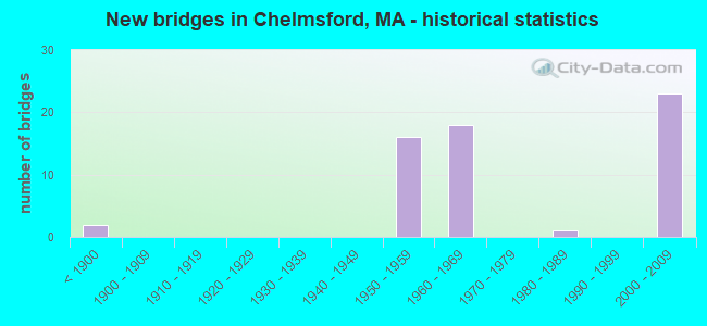
- New bridges - historical statistics
- 2Before 1900
- 161950-1959
- 181960-1969
- 11980-1989
- 232000-2009

- Reconstructed bridges - Historical Statistics
- 11900-1909
- 01910-1919
- 01920-1929
- 01930-1939
- 01940-1949
- 01950-1959
- 01960-1969
- 51970-1979
- 01980-1989
- 11990-1999
- 12000-2009
- 22010-2019


- Bridge Condition - Deck
- 45.2%Good
- 21.4%Satisfactory
- 28.6%Fair
- 2.4%Poor
- 2.4%Serious

- Bridge Condition - Superstructure
- 43.2%Good
- 31.8%Satisfactory
- 20.5%Fair
- 4.5%Poor

- Bridge Condition - Substructure
- 47.7%Good
- 31.8%Satisfactory
- 18.2%Fair
- 2.3%Poor

- Bridge Condition - Channel
- 16.7%Very good
- 41.7%Good
- 33.3%Satisfactory
- 8.3%Fair

- Bridge Condition - Culverts
- 16.7%Very good
- 16.7%Good
- 66.7%Satisfactory
Find on map >> Show street view
Structure Number: C08001A4RDOTNBI, Location: 0.8 KM N OF I 495 (Lat: 42.613283, Lng: -71.328922), Route carried "on" structure: US , Year Built: 2004, Status: Open, Structure Length: 3.01m (9.88ft), Average Daily Traffic: 27,673 (year 2019), Truck Traffic: 15%, Average Future Daily Traffic: 17,372 (year 2032), Design Load: HS 25 or greater, Features Intersected: ST110 CHELMSFORD ST, Facility Carried by Structure: US 3 CD SB
Minimum Vertical Clearance: 30+ m (98+ ft), Kilometerpoint: 130.723, Lanes on structure: 3, Lanes under structure: 5, Base Highway Network: Yes, Owner: State Highway Agency, Approaching Roadway Width: 12.3m (40.4ft), Skew: 10 degrees, Material/Design: Steel, Design/Construction: Stringer/Multi-beam, Number Of Spans In Main Unit: 1, Length of Maximum Span: 28.4m (93.2ft), Curb-To-Curb Width: 12.3m (40.4ft), Out-to-Out Width: 13.4m (44.0ft)
Condition: Deck: Good, Superstructure: Good, Substructure: Satisfactory, Operating Rating: 87.5 metric tons, Method Used To Determine Operating Rating: Load Factor (LF), Inventory Rating: 52.4 metric tons, Method Used To Determine Inventory Rating: Load Factor (LF), Structural Evaluation: Equal to present minimum criteria, Deck Geometry: High priority of replacement, Underclear: Meets minimum limits, Approach Roadway Alignment: Equal to present desirable criteria, Length Of Structure Improvement: 3.10m (10.17ft), Designated Inspection Frequency: Every 24 months, Inspection Date: May 2021, Bridge Improvement Cost: $1,783,000, Roadway Improvement Cost: $179,000, Total Project Cost: $2,675,000 ( Estimate for 2022), Deck Structure Type: Concrete Cast-file-Place, Wearing Surface/Protective System: Wearing Surface: Integral Concrete, Deck Protection: Epoxy Coated Reinforcing
Find on map >> Show street view
Structure Number: C08001ACMDOTNBI, Location: 0.8 KM N OF I 495 (Lat: 42.613375, Lng: -71.328725), Route carried "on" structure: US , Year Built: 2004, Status: Open, Structure Length: 3.01m (9.88ft), Average Daily Traffic: 42,155 (year 2019), Truck Traffic: 5%, Average Future Daily Traffic: 52,117 (year 2032), Design Load: HS 25 or greater, Features Intersected: ST110 CHELMSFORD ST, Facility Carried by Structure: US 3 SB
Minimum Vertical Clearance: 30+ m (98+ ft), Kilometerpoint: 130.723, Lanes on structure: 3, Lanes under structure: 5, Base Highway Network: Yes, Owner: State Highway Agency, Approaching Roadway Width: 34.0m (111.5ft), Skew: 30 degrees, Material/Design: Steel, Design/Construction: Stringer/Multi-beam, Number Of Spans In Main Unit: 1, Length of Maximum Span: 28.4m (93.2ft), Curb-To-Curb Width: 22.0m (72.2ft), Out-to-Out Width: 23.0m (75.5ft)
Condition: Deck: Satisfactory, Superstructure: Good, Substructure: Good, Operating Rating: 94.0 metric tons, Method Used To Determine Operating Rating: Load Factor (LF), Inventory Rating: 56.3 metric tons, Method Used To Determine Inventory Rating: Load Factor (LF), Structural Evaluation: Better than present minimum criteria, Deck Geometry: Superior to present desirable criteria, Underclear: Meets minimum limits, Approach Roadway Alignment: Equal to present desirable criteria, Length Of Structure Improvement: 3.10m (10.17ft), Designated Inspection Frequency: Every 24 months, Inspection Date: May 2021, Bridge Improvement Cost: $281,000, Roadway Improvement Cost: $29,000, Total Project Cost: $422,000 ( Estimate for 2022), Deck Structure Type: Concrete Cast-file-Place, Wearing Surface/Protective System: Wearing Surface: Integral Concrete, Membrane: Epoxy, Deck Protection: Epoxy Coated Reinforcing
Find on map >> Show street view
Structure Number: C0800281MMUNNBI, Location: @ STONY BROOK (Lat: 42.637500, Lng: -71.377194), Route carried "on" structure: City street , Year Built: 1850, Year Reconstructed: 1900, Status: Open, Structure Length: 0.82m (2.69ft), Average Daily Traffic: 2,208 (year 2019), Truck Traffic: 2%, Design Load: HS 20, Features Intersected: WATER STONY BROOK, Facility Carried by Structure: HWY MIDDLESEX ST
Minimum Vertical Clearance: 0.00m, Kilometerpoint: 0.000, Lanes on structure: 2, Owner: Town or Township Highway Agency, Maintenance Responsibility: City or Municipal Highway Agency, Approaching Roadway Width: 13.1m (43.0ft), Material/Design: Masonry, Design/Construction: Arch - Deck, Number Of Spans In Main Unit: 1, Length of Maximum Span: 7.7m (25.3ft), Curb-To-Curb Width: 13.1m (43.0ft), Out-to-Out Width: 13.1m (43.0ft)
Condition: Superstructure: Fair, Substructure: Satisfactory, Channel: Satisfactory, Operating Rating: 44.1 metric tons, Method Used To Determine Operating Rating: No rating analysis performed, Inventory Rating: 32.4 metric tons, Method Used To Determine Inventory Rating: No rating analysis performed, Structural Evaluation: Somewhat better than minimum adequacy, Deck Geometry: High priority of replacement, Waterway Adequacy: Equal to present desirable criteria, Approach Roadway Alignment: Somewhat better than minimum adequacy, Length Of Structure Improvement: 1.50m (4.92ft), Designated Inspection Frequency: Every 24 months, Inspection Date: March 2020, Bridge Improvement Cost: $1,053,000, Roadway Improvement Cost: $106,000, Total Project Cost: $1,580,000 ( Estimate for 2022), Wearing Surface/Protective System: Wearing Surface: Bituminous
Find on map >> Show street view
Structure Number: C080032MYDOT634, Location: 1.25 MI N DRUM HILL (Lat: 42.635669, Lng: -71.379011), Route carried "on" structure: Alternate State highway 3A, Year Built: 1956, Year Reconstructed: 2009, Status: Open, Structure Length: 2.68m (8.79ft), Average Daily Traffic: 21,207 (year 2019), Truck Traffic: 3%, Average Future Daily Traffic: 35,534 (year 2032), Design Load: HS 20, Features Intersected: COMB BMRR & STONY BROOK, Facility Carried by Structure: ST 3 A/PRNCETN ST
Minimum Vertical Clearance: 30+ m (98+ ft), Kilometerpoint: 111.980, Lanes on structure: 2, Owner: State Highway Agency, Approaching Roadway Width: 10.4m (34.1ft), Skew: 1 degrees, Material/Design: Steel continuous, Design/Construction: Stringer/Multi-beam, Number Of Spans In Main Unit: 2, Length of Maximum Span: 13.7m (44.9ft), Curb or Sidewalk Widths: Left: 1.5m (4.9ft), Right: 1.5m (4.9ft), Curb-To-Curb Width: 10.4m (34.1ft), Out-to-Out Width: 14.3m (46.9ft)
Condition: Deck: Good, Superstructure: Good, Substructure: Satisfactory, Channel: Good, Operating Rating: 79.0 metric tons, Method Used To Determine Operating Rating: Load Factor (LF), Inventory Rating: 47.3 metric tons, Method Used To Determine Inventory Rating: Load Factor (LF), Structural Evaluation: Equal to present minimum criteria, Deck Geometry: Meets minimum limits, Underclear: High priority of corrective action, Waterway Adequacy: Equal to present desirable criteria, Approach Roadway Alignment: Equal to present desirable criteria, Length Of Structure Improvement: 2.70m (8.86ft), Designated Inspection Frequency: Every 24 months, Inspection Date: November 2021, Bridge Improvement Cost: $764,000, Roadway Improvement Cost: $77,000, Total Project Cost: $1,147,000 ( Estimate for 2022), Deck Structure Type: Concrete Cast-file-Place, Wearing Surface/Protective System: Wearing Surface: Monolithic Concrete, Membrane: Other, Deck Protection: Epoxy Coated Reinforcing
Find on map >> Show street view
Structure Number: C080048FQMUNNBI, Location: 02 MI S OF RT 3 (Lat: 42.623067, Lng: -71.392883), Route carried "on" structure: City street , Year Built: 2001, Status: Open, Structure Length: 0.65m (2.13ft), Average Daily Traffic: 2,500 (year 2018), Truck Traffic: 5%, Average Future Daily Traffic: 4,106 (year 2033), Design Load: HS 20, Features Intersected: WATER STONY BROOK, Facility Carried by Structure: HWY MEADOWBRK RD
Minimum Vertical Clearance: 99.00m (324.80ft), Kilometerpoint: 0.322, Lanes on structure: 2, Owner: Town or Township Highway Agency, Approaching Roadway Width: 8.2m (26.9ft), Material/Design: Concrete, Design/Construction: Culvert, Number Of Spans In Main Unit: 2, Length of Maximum Span: 3.1m (10.2ft), Curb-To-Curb Width: 8.2m (26.9ft), Out-to-Out Width: 9.1m (29.9ft)
Condition: Channel: Very good, Culverts: Satisfactory, Operating Rating: 60.2 metric tons, Method Used To Determine Operating Rating: Load Factor (LF), Inventory Rating: 36.1 metric tons, Method Used To Determine Inventory Rating: Load Factor (LF), Structural Evaluation: Equal to present minimum criteria, Deck Geometry: High priority of corrective action, Waterway Adequacy: Better than present minimum criteria, Approach Roadway Alignment: Equal to present desirable criteria, Length Of Structure Improvement: 0.60m (1.97ft), Designated Inspection Frequency: Every 24 months, Inspection Date: March 2020, Bridge Improvement Cost: $368,000, Roadway Improvement Cost: $37,000, Total Project Cost: $553,000 ( Estimate for 2022), Wearing Surface/Protective System: Wearing Surface: Other, Membrane: Other, Deck Protection: Other
Find on map >> Show street view
Structure Number: C080052BCMUNNBI, Location: 1.0 KM SE OF MAIN ST (Lat: 42.617867, Lng: -71.402153), Route carried "on" structure: City street , Year Built: 1850, Status: Open, Structure Length: 1.22m (4.00ft), Average Daily Traffic: 3,750 (year 2019), Truck Traffic: 13%, Average Future Daily Traffic: 5,685 (year 2032), Features Intersected: WATER STONY BROOK, Facility Carried by Structure: HWY SCHOOL ST
Minimum Vertical Clearance: 30+ m (98+ ft), Kilometerpoint: 1.722, Lanes on structure: 2, Owner: Town or Township Highway Agency, Approaching Roadway Width: 7.9m (25.9ft), Skew: 1 degrees, Material/Design: Masonry, Design/Construction: Arch - Deck, Number Of Spans In Main Unit: 2, Length of Maximum Span: 5.5m (18.0ft), Curb or Sidewalk Widths: Left: 2.0m (6.6ft), Right: 1.9m (6.2ft), Curb-To-Curb Width: 8.0m (26.2ft), Out-to-Out Width: 13.1m (43.0ft)
Condition: Superstructure: Fair, Substructure: Fair, Channel: Satisfactory, Operating Rating: 33.6 metric tons, Method Used To Determine Operating Rating: Allowable Stress (AS), Inventory Rating: 33.6 metric tons, Method Used To Determine Inventory Rating: Allowable Stress (AS), Structural Evaluation: Somewhat better than minimum adequacy, Deck Geometry: High priority of corrective action, Waterway Adequacy: Better than present minimum criteria, Approach Roadway Alignment: Equal to present minimum criteria, Length Of Structure Improvement: 1.30m (4.27ft), Designated Inspection Frequency: Every 24 months, Underwater Inspection Frequency: Every 36 months, Inspection Date: September 2021, Underwater Inspection Date: March 2019, Bridge Improvement Cost: $669,000, Roadway Improvement Cost: $67,000, Total Project Cost: $1,004,000 ( Estimate for 2022), Wearing Surface/Protective System: Wearing Surface: Bituminous
Find on map >> Show street view
Structure Number: C080072BDMUNNBI, Location: JUST E OF MAIN ST (Lat: 42.597794, Lng: -71.338594), Route carried "on" structure: City street , Year Built: 1984, Status: Open, Structure Length: 0.67m (2.20ft), Average Daily Traffic: 5,043 (year 2019), Truck Traffic: 8%, Average Future Daily Traffic: 5,685 (year 2032), Design Load: HS 20, Features Intersected: WATER RIVER MEADOW BROOK, Facility Carried by Structure: HWY TURNPIKE RD
Minimum Vertical Clearance: 30+ m (98+ ft), Kilometerpoint: 0.241, Lanes on structure: 2, Owner: Town or Township Highway Agency, Approaching Roadway Width: 7.0m (23.0ft), Material/Design: Concrete, Design/Construction: Culvert, Number Of Spans In Main Unit: 2, Length of Maximum Span: 3.0m (9.8ft), Curb-To-Curb Width: 7.7m (25.3ft), Out-to-Out Width: 9.8m (32.2ft)
Condition: Channel: Satisfactory, Culverts: Satisfactory, Operating Rating: 72.0 metric tons, Method Used To Determine Operating Rating: Load Factor (LF), Inventory Rating: 43.2 metric tons, Method Used To Determine Inventory Rating: Load Factor (LF), Structural Evaluation: Equal to present minimum criteria, Deck Geometry: High priority of replacement, Waterway Adequacy: Better than present minimum criteria, Approach Roadway Alignment: Equal to present desirable criteria, Length Of Structure Improvement: 0.60m (1.97ft), Designated Inspection Frequency: Every 24 months, Underwater Inspection Frequency: Every 36 months, Inspection Date: August 2021, Underwater Inspection Date: April 2019, Bridge Improvement Cost: $379,000, Roadway Improvement Cost: $38,000, Total Project Cost: $569,000 ( Estimate for 2022), Wearing Surface/Protective System: Wearing Surface: Bituminous
Find on map >> Show street view
Structure Number: C0801285PDOTNBI, Location: 0.8 KM N OF I 495 (Lat: 42.613561, Lng: -71.328289), Route carried "on" structure: US 3, Year Built: 2004, Status: Open, Structure Length: 3.01m (9.88ft), Average Daily Traffic: 27,673 (year 2019), Truck Traffic: 15%, Average Future Daily Traffic: 17,372 (year 2032), Design Load: HS 25 or greater, Features Intersected: ST110 CHELMSFORD ST
Minimum Vertical Clearance: 30+ m (98+ ft), Kilometerpoint: 130.723, Lanes on structure: 2, Lanes under structure: 5, Base Highway Network: Yes, Owner: State Highway Agency, Approaching Roadway Width: 11.1m (36.4ft), Skew: 30 degrees, Material/Design: Steel, Design/Construction: Stringer/Multi-beam, Number Of Spans In Main Unit: 1, Length of Maximum Span: 28.4m (93.2ft), Curb-To-Curb Width: 11.1m (36.4ft), Out-to-Out Width: 12.2m (40.0ft)
Condition: Deck: Good, Superstructure: Good, Substructure: Satisfactory, Operating Rating: 95.6 metric tons, Method Used To Determine Operating Rating: Load Factor (LF), Inventory Rating: 57.3 metric tons, Method Used To Determine Inventory Rating: Load Factor (LF), Structural Evaluation: Equal to present minimum criteria, Deck Geometry: Somewhat better than minimum adequacy, Underclear: Meets minimum limits, Approach Roadway Alignment: Equal to present desirable criteria, Length Of Structure Improvement: 3.10m (10.17ft), Designated Inspection Frequency: Every 24 months, Inspection Date: May 2021, Bridge Improvement Cost: $497,000, Roadway Improvement Cost: $50,000, Total Project Cost: $746,000 ( Estimate for 2022), Deck Structure Type: Concrete Cast-file-Place, Wearing Surface/Protective System: Wearing Surface: Integral Concrete, Deck Protection: Epoxy Coated Reinforcing
Find on map >> Show street view
Structure Number: C080129TJDOTNBI, Location: 0.8 KM N OF I 495 (Lat: 42.613478, Lng: -71.328486), Route carried "on" structure: US 3, Year Built: 2004, Status: Open, Structure Length: 3.01m (9.88ft), Average Daily Traffic: 27,931 (year 2019), Truck Traffic: 4%, Average Future Daily Traffic: 52,117 (year 2032), Design Load: HS 25 or greater, Features Intersected: ST110 CHELMSFORD ST
Minimum Vertical Clearance: 30+ m (98+ ft), Kilometerpoint: 130.723, Lanes on structure: 3, Lanes under structure: 5, Base Highway Network: Yes, Owner: State Highway Agency, Approaching Roadway Width: 34.0m (111.5ft), Skew: 30 degrees, Material/Design: Steel, Design/Construction: Stringer/Multi-beam, Number Of Spans In Main Unit: 1, Length of Maximum Span: 28.4m (93.2ft), Curb-To-Curb Width: 22.0m (72.2ft), Out-to-Out Width: 23.0m (75.5ft)
Condition: Deck: Satisfactory, Superstructure: Good, Substructure: Good, Operating Rating: 94.0 metric tons, Method Used To Determine Operating Rating: Load Factor (LF), Inventory Rating: 56.3 metric tons, Method Used To Determine Inventory Rating: Load Factor (LF), Structural Evaluation: Better than present minimum criteria, Deck Geometry: Superior to present desirable criteria, Underclear: Meets minimum limits, Approach Roadway Alignment: Equal to present desirable criteria, Length Of Structure Improvement: 3.10m (10.17ft), Designated Inspection Frequency: Every 24 months, Inspection Date: May 2021, Bridge Improvement Cost: $281,000, Roadway Improvement Cost: $29,000, Total Project Cost: $422,000 ( Estimate for 2022), Deck Structure Type: Concrete Cast-file-Place, Wearing Surface/Protective System: Wearing Surface: Integral Concrete, Deck Protection: Epoxy Coated Reinforcing
Find on map >> Show street view
Structure Number: C080148VVDOTNBI, Location: 0.25 MI SO RTE 110 (Lat: 42.605011, Lng: -71.324653), Route carried "on" structure: City street , Year Built: 2004, Status: Open, Structure Length: 9.60m (31.50ft), Average Daily Traffic: 6,700 (year 2021), Truck Traffic: 6%, Average Future Daily Traffic: 9,476 (year 2032), Design Load: HS 25 or greater, Features Intersected: US 3, Facility Carried by Structure: HWY RIVERNECK RD
Minimum Vertical Clearance: 30+ m (98+ ft), Kilometerpoint: 0.000, Lanes on structure: 2, Lanes under structure: 11, Owner: State Highway Agency, Approaching Roadway Width: 12.8m (42.0ft), Material/Design: Steel continuous, Design/Construction: Stringer/Multi-beam, Number Of Spans In Main Unit: 4, Length of Maximum Span: 26.9m (88.3ft), Curb or Sidewalk Widths: Left: 0.0m, Right: 1.7m (5.6ft), Curb-To-Curb Width: 12.8m (42.0ft), Out-to-Out Width: 15.3m (50.2ft)
Condition: Deck: Good, Superstructure: Satisfactory, Substructure: Good, Operating Rating: 67.7 metric tons, Method Used To Determine Operating Rating: Load Factor (LF), Inventory Rating: 40.5 metric tons, Method Used To Determine Inventory Rating: Load Factor (LF), Structural Evaluation: Equal to present minimum criteria, Deck Geometry: Somewhat better than minimum adequacy, Underclear: High priority of corrective action, Approach Roadway Alignment: Equal to present desirable criteria, Length Of Structure Improvement: 9.70m (31.82ft), Designated Inspection Frequency: Every 24 months, Inspection Date: May 2021, Bridge Improvement Cost: $526,000, Roadway Improvement Cost: $53,000, Total Project Cost: $790,000 ( Estimate for 2022), Deck Structure Type: Concrete Cast-file-Place, Wearing Surface/Protective System: Wearing Surface: Integral Concrete, Deck Protection: Epoxy Coated Reinforcing
Find on map >> Show street view
Structure Number: C080157D4DOTNBI, Location: 0.75 MI E DRUM HILL (Lat: 42.620428, Lng: -71.350692), Route carried "on" structure: City street , Year Built: 2004, Status: Open, Structure Length: 7.48m (24.54ft), Average Daily Traffic: 8,911 (year 2017), Truck Traffic: 6%, Average Future Daily Traffic: 12,161 (year 2032), Design Load: HS 25 or greater, Features Intersected: US 3, Facility Carried by Structure: HWY STEADMAN ST
Minimum Vertical Clearance: 30+ m (98+ ft), Kilometerpoint: 0.000, Lanes on structure: 2, Lanes under structure: 6, Owner: State Highway Agency, Approaching Roadway Width: 15.3m (50.2ft), Skew: 3 degrees, Material/Design: Steel continuous, Design/Construction: Stringer/Multi-beam, Number Of Spans In Main Unit: 2, Length of Maximum Span: 36.5m (119.8ft), Curb or Sidewalk Widths: Left: 1.6m (5.2ft), Right: 1.6m (5.2ft), Curb-To-Curb Width: 12.8m (42.0ft), Out-to-Out Width: 15.3m (50.2ft)
Condition: Deck: Good, Superstructure: Satisfactory, Substructure: Good, Operating Rating: 56.4 metric tons, Method Used To Determine Operating Rating: Load Factor (LF), Inventory Rating: 33.7 metric tons, Method Used To Determine Inventory Rating: Load Factor (LF), Structural Evaluation: Equal to present minimum criteria, Deck Geometry: Somewhat better than minimum adequacy, Underclear: Equal to present minimum criteria, Approach Roadway Alignment: Equal to present desirable criteria, Length Of Structure Improvement: 7.50m (24.61ft), Designated Inspection Frequency: Every 24 months, Inspection Date: March 2021, Bridge Improvement Cost: $425,000, Roadway Improvement Cost: $43,000, Total Project Cost: $638,000 ( Estimate for 2022), Deck Structure Type: Concrete Cast-file-Place, Wearing Surface/Protective System: Wearing Surface: Integral Concrete, Membrane: Epoxy, Deck Protection: Epoxy Coated Reinforcing
Find on map >> Show street view
Structure Number: C080178EFDOTNBI, Location: 0.4 KM S. DRUM HIL (Lat: 42.620750, Lng: -71.359806), Route carried "on" structure: US 3, Year Built: 2004, Status: Open, Structure Length: 1.85m (6.07ft), Average Daily Traffic: 100,800 (year 2017), Truck Traffic: 10%, Average Future Daily Traffic: 138,978 (year 2032), Design Load: HS 25 or greater, Features Intersected: HWY PARKHURST RD
Minimum Vertical Clearance: 30+ m (98+ ft), Kilometerpoint: 135.986, Lanes on structure: 4, Lanes under structure: 2, Base Highway Network: Yes, Owner: State Highway Agency, Approaching Roadway Width: 23.1m (75.8ft), Skew: 1 degrees, Material/Design: Steel, Design/Construction: Stringer/Multi-beam, Number Of Spans In Main Unit: 1, Length of Maximum Span: 16.7m (54.8ft), Curb-To-Curb Width: 23.1m (75.8ft), Out-to-Out Width: 24.2m (79.4ft)
Condition: Deck: Satisfactory, Superstructure: Good, Substructure: Good, Operating Rating: 86.5 metric tons, Method Used To Determine Operating Rating: Load Factor (LF), Inventory Rating: 51.8 metric tons, Method Used To Determine Inventory Rating: Load Factor (LF), Structural Evaluation: Better than present minimum criteria, Deck Geometry: Superior to present desirable criteria, Underclear: Meets minimum limits, Approach Roadway Alignment: Better than present minimum criteria, Length Of Structure Improvement: 1.90m (6.23ft), Designated Inspection Frequency: Every 24 months, Inspection Date: May 2021, Bridge Improvement Cost: $181,000, Roadway Improvement Cost: $19,000, Total Project Cost: $272,000 ( Estimate for 2022), Deck Structure Type: Concrete Cast-file-Place, Wearing Surface/Protective System: Wearing Surface: Monolithic Concrete, Deck Protection: Epoxy Coated Reinforcing
Find on map >> Show street view
Structure Number: C080178EGDOTNBI, Location: 0.4 KM S. DRUM HIL (Lat: 42.621194, Lng: -71.359861), Route carried "on" structure: US 3, Year Built: 2004, Status: Open, Structure Length: 1.85m (6.07ft), Average Daily Traffic: 100,800 (year 2017), Truck Traffic: 10%, Average Future Daily Traffic: 138,978 (year 2032), Design Load: HS 25 or greater, Features Intersected: HWY PARKHURST RD
Minimum Vertical Clearance: 30+ m (98+ ft), Kilometerpoint: 135.986, Lanes on structure: 4, Lanes under structure: 2, Base Highway Network: Yes, Owner: State Highway Agency, Approaching Roadway Width: 23.1m (75.8ft), Skew: 1 degrees, Material/Design: Steel, Design/Construction: Stringer/Multi-beam, Number Of Spans In Main Unit: 1, Length of Maximum Span: 16.7m (54.8ft), Curb-To-Curb Width: 23.1m (75.8ft), Out-to-Out Width: 24.2m (79.4ft)
Condition: Deck: Satisfactory, Superstructure: Good, Substructure: Good, Operating Rating: 86.5 metric tons, Method Used To Determine Operating Rating: Load Factor (LF), Inventory Rating: 51.8 metric tons, Method Used To Determine Inventory Rating: Load Factor (LF), Structural Evaluation: Better than present minimum criteria, Deck Geometry: Superior to present desirable criteria, Underclear: Meets minimum limits, Approach Roadway Alignment: Better than present minimum criteria, Length Of Structure Improvement: 1.90m (6.23ft), Designated Inspection Frequency: Every 24 months, Inspection Date: May 2021, Bridge Improvement Cost: $181,000, Roadway Improvement Cost: $19,000, Total Project Cost: $272,000 ( Estimate for 2022), Deck Structure Type: Concrete Cast-file-Place, Wearing Surface/Protective System: Wearing Surface: Monolithic Concrete, Deck Protection: Epoxy Coated Reinforcing
Find on map >> Show street view
Structure Number: C0801885UDOTNBI, Location: 2.2 MI N OF I 495 (Lat: 42.622217, Lng: -71.365314), Route carried "on" structure: State highway 4, Year Built: 2004, Status: Open, Structure Length: 5.00m (16.40ft), Average Daily Traffic: 14,416 (year 2018), Truck Traffic: 7%, Average Future Daily Traffic: 23,058 (year 2032), Design Load: HS 25 or greater, Features Intersected: US 3 NB/SB
Minimum Vertical Clearance: 0.00m, Kilometerpoint: 0.000, Lanes on structure: 4, Lanes under structure: 8, Owner: State Highway Agency, Approaching Roadway Width: 20.7m (67.9ft), Skew: 1 degrees, Material/Design: Steel continuous, Design/Construction: Stringer/Multi-beam, Number Of Spans In Main Unit: 2, Length of Maximum Span: 24.0m (78.7ft), Curb or Sidewalk Widths: Left: 1.7m (5.6ft), Right: 0.0m, Curb-To-Curb Width: 20.7m (67.9ft), Out-to-Out Width: 23.2m (76.1ft)
Condition: Deck: Good, Superstructure: Good, Substructure: Good, Operating Rating: 94.8 metric tons, Method Used To Determine Operating Rating: Load Factor (LF), Inventory Rating: 56.8 metric tons, Method Used To Determine Inventory Rating: Load Factor (LF), Structural Evaluation: Better than present minimum criteria, Deck Geometry: Superior to present desirable criteria, Underclear: Equal to present minimum criteria, Approach Roadway Alignment: Equal to present desirable criteria, Length Of Structure Improvement: 5.10m (16.73ft), Designated Inspection Frequency: Every 24 months, Inspection Date: May 2021, Bridge Improvement Cost: $674,000, Roadway Improvement Cost: $68,000, Total Project Cost: $1,012,000 ( Estimate for 2022), Deck Structure Type: Concrete Cast-file-Place, Wearing Surface/Protective System: Wearing Surface: Integral Concrete, Deck Protection: Epoxy Coated Reinforcing
Find on map >> Show street view
Structure Number: C0801985QDOTNBI, Location: 2.2 MI N OF I 495 (Lat: 42.622617, Lng: -71.367211), Route carried "on" structure: State highway 4, Year Built: 2004, Status: Open, Structure Length: 5.00m (16.40ft), Average Daily Traffic: 14,018 (year 2018), Truck Traffic: 7%, Average Future Daily Traffic: 23,058 (year 2032), Design Load: HS 25 or greater, Features Intersected: US 3 NB/SB
Minimum Vertical Clearance: 30+ m (98+ ft), Kilometerpoint: 0.000, Lanes on structure: 4, Lanes under structure: 8, Owner: State Highway Agency, Approaching Roadway Width: 18.9m (62.0ft), Material/Design: Steel continuous, Design/Construction: Stringer/Multi-beam, Number Of Spans In Main Unit: 2, Length of Maximum Span: 24.0m (78.7ft), Curb or Sidewalk Widths: Left: 0.0m, Right: 1.7m (5.6ft), Curb-To-Curb Width: 18.9m (62.0ft), Out-to-Out Width: 21.4m (70.2ft)
Condition: Deck: Good, Superstructure: Good, Substructure: Good, Operating Rating: 87.0 metric tons, Method Used To Determine Operating Rating: Load Factor (LF), Inventory Rating: 52.1 metric tons, Method Used To Determine Inventory Rating: Load Factor (LF), Structural Evaluation: Better than present minimum criteria, Deck Geometry: Equal to present minimum criteria, Underclear: Equal to present minimum criteria, Approach Roadway Alignment: Equal to present desirable criteria, Length Of Structure Improvement: 5.10m (16.73ft), Designated Inspection Frequency: Every 24 months, Inspection Date: May 2021, Bridge Improvement Cost: $1,539,000, Roadway Improvement Cost: $154,000, Total Project Cost: $2,309,000 ( Estimate for 2022), Deck Structure Type: Concrete Cast-file-Place, Wearing Surface/Protective System: Wearing Surface: Integral Concrete, Deck Protection: Epoxy Coated Reinforcing
Find on map >> Show street view
Structure Number: C080222CTMUNNBI, Location: .16 KM S OF RT 3 (Lat: 42.625764, Lng: -71.394014), Route carried "on" structure: City street , Year Built: 1950, Year Reconstructed: 2018, Status: Posted for load, Structure Length: 0.73m (2.40ft), Average Daily Traffic: 1,300 (year 2020), Average Future Daily Traffic: 2,211 (year 2032), Features Intersected: WATER CANAL, Facility Carried by Structure: HWY MEADOWBRK RD
Minimum Vertical Clearance: 30+ m (98+ ft), Kilometerpoint: 1.000, Lanes on structure: 2, Owner: Town or Township Highway Agency, Approaching Roadway Width: 8.1m (26.6ft), Material/Design: Steel, Design/Construction: Culvert, Number Of Spans In Main Unit: 4, Length of Maximum Span: 1.7m (5.6ft), Curb-To-Curb Width: 8.1m (26.6ft), Out-to-Out Width: 9.3m (30.5ft)
Condition: Channel: Very good, Culverts: Very good, Operating Rating: 45.4 metric tons, Method Used To Determine Operating Rating: Load and Resistance Factor Rating (LRFR) rating reported by rating factor(RF) method using HL-93 loadings, Inventory Rating: 45.4 metric tons, Method Used To Determine Inventory Rating: Load and Resistance Factor Rating (LRFR) rating reported by rating factor(RF) method using HL-93 loadings, Structural Evaluation: Equal to present desirable criteria, Deck Geometry: Meets minimum limits, Waterway Adequacy: Better than present minimum criteria, Approach Roadway Alignment: Equal to present minimum criteria, Designated Inspection Frequency: Every 24 months, Underwater Inspection Frequency: Every 36 months, Inspection Date: August 2020, Underwater Inspection Date: June 2021, Wearing Surface/Protective System: Wearing Surface: Bituminous
Find on map >> Show street view
Structure Number: C08024AY7DOTNBI, Location: RT 129 AT RT 3 (Lat: 42.588981, Lng: -71.312972), Route carried "on" structure: State highway 129, Year Built: 2004, Status: Open, Structure Length: 8.70m (28.54ft), Average Daily Traffic: 25,000 (year 2019), Truck Traffic: 6%, Average Future Daily Traffic: 38,693 (year 2032), Design Load: HS 25 or greater, Features Intersected: US 3
Minimum Vertical Clearance: 30+ m (98+ ft), Kilometerpoint: 35.810, Lanes on structure: 4, Lanes under structure: 6, Owner: State Highway Agency, Approaching Roadway Width: 20.2m (66.3ft), Skew: 4 degrees, Material/Design: Steel continuous, Design/Construction: Stringer/Multi-beam, Number Of Spans In Main Unit: 2, Length of Maximum Span: 42.5m (139.4ft), Curb or Sidewalk Widths: Left: 1.7m (5.6ft), Right: 0.0m, Curb-To-Curb Width: 20.2m (66.3ft), Out-to-Out Width: 22.7m (74.5ft)
Condition: Deck: Good, Superstructure: Satisfactory, Substructure: Good, Operating Rating: 91.5 metric tons, Method Used To Determine Operating Rating: Load Factor (LF), Inventory Rating: 54.8 metric tons, Method Used To Determine Inventory Rating: Load Factor (LF), Structural Evaluation: Equal to present minimum criteria, Deck Geometry: Better than present minimum criteria, Underclear: Better than present minimum criteria, Approach Roadway Alignment: Equal to present desirable criteria, Length Of Structure Improvement: 8.80m (28.87ft), Designated Inspection Frequency: Every 24 months, Inspection Date: May 2021, Bridge Improvement Cost: $1,577,000, Roadway Improvement Cost: $158,000, Total Project Cost: $2,366,000 ( Estimate for 2022), Deck Structure Type: Concrete Cast-file-Place, Wearing Surface/Protective System: Wearing Surface: Integral Concrete, Deck Protection: Epoxy Coated Reinforcing
Find on map >> Show street view
Structure Number: C080252J9DOTNBI, Location: RT 495 AT RT 110 (Lat: 42.605169, Lng: -71.344600), Route carried "on" structure: Interstate 495, Year Built: 1960, Status: Temporarily open, Structure Length: 5.19m (17.03ft), Average Daily Traffic: 55,955 (year 2019), Truck Traffic: 5%, Average Future Daily Traffic: 175,302 (year 2031), Design Load: HS 20, Features Intersected: ST110 CHELMSFORD ST
Minimum Vertical Clearance: 30+ m (98+ ft), Kilometerpoint: 142.034, Lanes on structure: 3, Lanes under structure: 2, Base Highway Network: Yes, Owner: State Highway Agency, Approaching Roadway Width: 15.8m (51.8ft), Skew: 14 degrees, Material/Design: Steel, Design/Construction: Stringer/Multi-beam, Number Of Spans In Main Unit: 3, Length of Maximum Span: 25.3m (83.0ft), Curb or Sidewalk Widths: Left: 0.3m (1.0ft), Right: 0.6m (2.0ft), Curb-To-Curb Width: 15.8m (51.8ft), Out-to-Out Width: 18.3m (60.0ft)
Condition: Deck: Fair, Superstructure: Poor, Substructure: Fair, Operating Rating: 54.3 metric tons, Method Used To Determine Operating Rating: Load Factor (LF), Inventory Rating: 32.5 metric tons, Method Used To Determine Inventory Rating: Load Factor (LF), Structural Evaluation: Meets minimum limits, Deck Geometry: Somewhat better than minimum adequacy, Underclear: Equal to present minimum criteria, Approach Roadway Alignment: Equal to present desirable criteria, Length Of Structure Improvement: 5.20m (17.06ft), Designated Inspection Frequency: Every 12 months, Other Special Inspection Frequency: Every 12 months, Inspection Date: December 2020, Other Special Inspection Date: December 2021, Bridge Improvement Cost: $3,738,000, Roadway Improvement Cost: $374,000, Total Project Cost: $5,608,000 ( Estimate for 2022), Deck Structure Type: Concrete Cast-file-Place, Wearing Surface/Protective System: Wearing Surface: Bituminous
Find on map >> Show street view
Structure Number: C080252JADOTNBI, Location: RT 495 AT RT 110 (Lat: 42.605464, Lng: -71.344422), Route carried "on" structure: Interstate 495, Year Built: 1960, Status: Temporarily open, Structure Length: 5.19m (17.03ft), Average Daily Traffic: 54,901 (year 2019), Truck Traffic: 5%, Average Future Daily Traffic: 14,372 (year 2031), Design Load: HS 20+Mod, Features Intersected: ST110 CHELMSFORD ST
Minimum Vertical Clearance: 30+ m (98+ ft), Kilometerpoint: 142.034, Lanes on structure: 4, Lanes under structure: 2, Base Highway Network: Yes, Owner: State Highway Agency, Approaching Roadway Width: 15.8m (51.8ft), Skew: 14 degrees, Material/Design: Steel, Design/Construction: Stringer/Multi-beam, Number Of Spans In Main Unit: 3, Length of Maximum Span: 25.3m (83.0ft), Curb or Sidewalk Widths: Left: 0.7m (2.3ft), Right: 0.4m (1.3ft), Curb-To-Curb Width: 15.8m (51.8ft), Out-to-Out Width: 18.3m (60.0ft)
Condition: Deck: Fair, Superstructure: Fair, Substructure: Fair, Operating Rating: 54.3 metric tons, Method Used To Determine Operating Rating: Load Factor (LF), Inventory Rating: 32.5 metric tons, Method Used To Determine Inventory Rating: Load Factor (LF), Structural Evaluation: Somewhat better than minimum adequacy, Deck Geometry: High priority of replacement, Underclear: Meets minimum limits, Approach Roadway Alignment: Equal to present desirable criteria, Length Of Structure Improvement: 5.20m (17.06ft), Designated Inspection Frequency: Every 24 months, Inspection Date: December 2020, Bridge Improvement Cost: $3,738,000, Roadway Improvement Cost: $374,000, Total Project Cost: $5,608,000 ( Estimate for 2022), Deck Structure Type: Concrete Cast-file-Place, Wearing Surface/Protective System: Wearing Surface: Bituminous
Find on map >> Show street view
Structure Number: C080262JBDOTNBI, Location: 0.1 MI E RT 110 (Lat: 42.605672, Lng: -71.342303), Route carried "on" structure: Interstate 495, Year Built: 1960, Status: Open, Structure Length: 3.29m (10.79ft), Average Daily Traffic: 88,200 (year 2015), Truck Traffic: 7%, Average Future Daily Traffic: 139,294 (year 2032), Design Load: H 20, Features Intersected: HWY GOLDEN COVE RD
Minimum Vertical Clearance: 30+ m (98+ ft), Kilometerpoint: 142.407, Lanes on structure: 4, Lanes under structure: 2, Base Highway Network: Yes, Owner: State Highway Agency, Approaching Roadway Width: 21.3m (69.9ft), Skew: 10 degrees, Material/Design: Steel, Design/Construction: Stringer/Multi-beam, Number Of Spans In Main Unit: 3, Length of Maximum Span: 13.1m (43.0ft), Curb or Sidewalk Widths: Left: 0.6m (2.0ft), Right: 0.6m (2.0ft), Curb-To-Curb Width: 21.3m (69.9ft), Out-to-Out Width: 36.3m (119.1ft)
Condition: Deck: Fair, Superstructure: Satisfactory, Substructure: Satisfactory, Operating Rating: 57.6 metric tons, Method Used To Determine Operating Rating: Load Factor (LF), Inventory Rating: 34.5 metric tons, Method Used To Determine Inventory Rating: Load Factor (LF), Structural Evaluation: Equal to present minimum criteria, Deck Geometry: Better than present minimum criteria, Underclear: Meets minimum limits, Approach Roadway Alignment: Equal to present desirable criteria, Length Of Structure Improvement: 3.30m (10.83ft), Designated Inspection Frequency: Every 24 months, Inspection Date: March 2021, Bridge Improvement Cost: $4,013,000, Roadway Improvement Cost: $402,000, Total Project Cost: $6,020,000 ( Estimate for 2022), Deck Structure Type: Concrete Cast-file-Place, Wearing Surface/Protective System: Wearing Surface: Integral Concrete
Find on map >> Show street view
Structure Number: C080262JCDOTNBI, Location: 0.1 MI E RT 110 (Lat: 42.605833, Lng: -71.342411), Route carried "on" structure: Interstate 495, Year Built: 1960, Status: Open, Structure Length: 3.29m (10.79ft), Average Daily Traffic: 88,200 (year 2015), Truck Traffic: 7%, Average Future Daily Traffic: 139,294 (year 2032), Design Load: H 20, Features Intersected: HWY GOLDEN COVE RD
Minimum Vertical Clearance: 30+ m (98+ ft), Kilometerpoint: 142.407, Lanes on structure: 3, Lanes under structure: 2, Base Highway Network: Yes, Owner: State Highway Agency, Approaching Roadway Width: 15.2m (49.9ft), Skew: 10 degrees, Material/Design: Steel, Design/Construction: Stringer/Multi-beam, Number Of Spans In Main Unit: 3, Length of Maximum Span: 13.1m (43.0ft), Curb or Sidewalk Widths: Left: 0.6m (2.0ft), Right: 0.6m (2.0ft), Curb-To-Curb Width: 15.2m (49.9ft), Out-to-Out Width: 17.4m (57.1ft)
Condition: Deck: Fair, Superstructure: Satisfactory, Substructure: Fair, Operating Rating: 57.1 metric tons, Method Used To Determine Operating Rating: Load Factor (LF), Inventory Rating: 34.2 metric tons, Method Used To Determine Inventory Rating: Load Factor (LF), Structural Evaluation: Somewhat better than minimum adequacy, Deck Geometry: Meets minimum limits, Underclear: Meets minimum limits, Approach Roadway Alignment: Equal to present desirable criteria, Length Of Structure Improvement: 3.30m (10.83ft), Designated Inspection Frequency: Every 24 months, Inspection Date: March 2021, Bridge Improvement Cost: $2,256,000, Roadway Improvement Cost: $226,000, Total Project Cost: $3,385,000 ( Estimate for 2022), Deck Structure Type: Concrete Cast-file-Place, Wearing Surface/Protective System: Wearing Surface: Bituminous
Find on map >> Show street view
Structure Number: C080272JDDOTNBI, Location: .5 MILE N. OF RT 110 (Lat: 42.606200, Lng: -71.339975), Route carried "on" structure: Interstate 495, Year Built: 1959, Status: Open, Structure Length: 2.71m (8.89ft), Average Daily Traffic: 113,100 (year 2016), Truck Traffic: 10%, Average Future Daily Traffic: 170,091 (year 2031), Design Load: HS 20, Features Intersected: OTHER BIKE PATH
Minimum Vertical Clearance: 30+ m (98+ ft), Kilometerpoint: 142.745, Lanes on structure: 3, Base Highway Network: Yes, Owner: State Highway Agency, Approaching Roadway Width: 15.8m (51.8ft), Skew: 16 degrees, Material/Design: Steel, Design/Construction: Stringer/Multi-beam, Number Of Spans In Main Unit: 1, Length of Maximum Span: 25.6m (84.0ft), Curb or Sidewalk Widths: Left: 0.4m (1.3ft), Right: 0.6m (2.0ft), Curb-To-Curb Width: 15.2m (49.9ft), Out-to-Out Width: 17.4m (57.1ft)
Condition: Deck: Fair, Superstructure: Satisfactory, Substructure: Fair, Operating Rating: 54.8 metric tons, Method Used To Determine Operating Rating: Load Factor (LF), Inventory Rating: 32.8 metric tons, Method Used To Determine Inventory Rating: Load Factor (LF), Structural Evaluation: Somewhat better than minimum adequacy, Deck Geometry: Meets minimum limits, Approach Roadway Alignment: Equal to present desirable criteria, Length Of Structure Improvement: 2.80m (9.19ft), Designated Inspection Frequency: Every 24 months, Inspection Date: December 2020, Bridge Improvement Cost: $1,914,000, Roadway Improvement Cost: $192,000, Total Project Cost: $2,872,000 ( Estimate for 2022), Deck Structure Type: Concrete Cast-file-Place, Wearing Surface/Protective System: Wearing Surface: Bituminous
Find on map >> Show street view
Structure Number: C080272JEDOTNBI, Location: 0.5 MILE N. OF RTE 110 (Lat: 42.606519, Lng: -71.339367), Route carried "on" structure: Interstate 495, Year Built: 1959, Status: Open, Structure Length: 2.71m (8.89ft), Average Daily Traffic: 113,100 (year 2016), Truck Traffic: 10%, Average Future Daily Traffic: 170,091 (year 2031), Design Load: HS 20, Features Intersected: OTHER BIKE PATH
Minimum Vertical Clearance: 30+ m (98+ ft), Kilometerpoint: 142.745, Lanes on structure: 3, Base Highway Network: Yes, Owner: State Highway Agency, Approaching Roadway Width: 15.8m (51.8ft), Skew: 16 degrees, Material/Design: Steel, Design/Construction: Stringer/Multi-beam, Number Of Spans In Main Unit: 1, Length of Maximum Span: 25.6m (84.0ft), Curb or Sidewalk Widths: Left: 0.3m (1.0ft), Right: 0.4m (1.3ft), Curb-To-Curb Width: 15.2m (49.9ft), Out-to-Out Width: 18.3m (60.0ft)
Condition: Deck: Fair, Superstructure: Satisfactory, Substructure: Satisfactory, Operating Rating: 56.8 metric tons, Method Used To Determine Operating Rating: Load Factor (LF), Inventory Rating: 34.0 metric tons, Method Used To Determine Inventory Rating: Load Factor (LF), Structural Evaluation: Equal to present minimum criteria, Deck Geometry: Meets minimum limits, Approach Roadway Alignment: Equal to present desirable criteria, Length Of Structure Improvement: 2.80m (9.19ft), Designated Inspection Frequency: Every 24 months, Inspection Date: December 2020, Bridge Improvement Cost: $2,455,000, Roadway Improvement Cost: $246,000, Total Project Cost: $3,683,000 ( Estimate for 2022), Deck Structure Type: Concrete Cast-file-Place, Wearing Surface/Protective System: Wearing Surface: Monolithic Concrete
Find on map >> Show street view
Structure Number: C080282LTDOTNBI, Location: 0.7 MI N RTE 110 (Lat: 42.606942, Lng: -71.332592), Route carried "on" structure: Interstate 495, Year Built: 1959, Status: Open, Structure Length: 1.34m (4.40ft), Average Daily Traffic: 54,200 (year 2020), Truck Traffic: 10%, Average Future Daily Traffic: 168,511 (year 2031), Design Load: HS 20, Features Intersected: WATER RIVER MEADOW BROOK
Minimum Vertical Clearance: 30+ m (98+ ft), Kilometerpoint: 0.000, Lanes on structure: 3, Base Highway Network: Yes, Owner: State Highway Agency, Approaching Roadway Width: 19.5m (64.0ft), Skew: 11 degrees, Material/Design: Steel, Design/Construction: Stringer/Multi-beam, Number Of Spans In Main Unit: 1, Length of Maximum Span: 11.9m (39.0ft), Curb or Sidewalk Widths: Left: 0.0m, Right: 0.8m (2.6ft), Curb-To-Curb Width: 19.5m (64.0ft), Out-to-Out Width: 21.6m (70.9ft)
Condition: Deck: Fair, Superstructure: Satisfactory, Substructure: Good, Channel: Good, Operating Rating: 50.1 metric tons, Method Used To Determine Operating Rating: Load Factor (LF), Inventory Rating: 30.0 metric tons, Method Used To Determine Inventory Rating: Load Factor (LF), Structural Evaluation: Equal to present minimum criteria, Deck Geometry: Superior to present desirable criteria, Waterway Adequacy: Equal to present desirable criteria, Approach Roadway Alignment: Equal to present desirable criteria, Length Of Structure Improvement: 1.40m (4.59ft), Designated Inspection Frequency: Every 24 months, Inspection Date: November 2020, Bridge Improvement Cost: $1,188,000, Roadway Improvement Cost: $119,000, Total Project Cost: $1,783,000 ( Estimate for 2022), Deck Structure Type: Concrete Cast-file-Place, Wearing Surface/Protective System: Wearing Surface: Bituminous
Find on map >> Show street view
Structure Number: C080282LUDOTNBI, Location: 0.7 MI NO RT 110 (Lat: 42.607103, Lng: -71.332586), Route carried "on" structure: Interstate 495, Year Built: 1959, Year Reconstructed: 1975, Status: Open, Structure Length: 1.34m (4.40ft), Average Daily Traffic: 60,000 (year 2020), Truck Traffic: 9%, Average Future Daily Traffic: 168,511 (year 2031), Design Load: HS 20, Features Intersected: WATER RIVER MEADOW BROOK
Minimum Vertical Clearance: 30+ m (98+ ft), Kilometerpoint: 0.000, Lanes on structure: 5, Base Highway Network: Yes, Owner: State Highway Agency, Approaching Roadway Width: 28.3m (92.8ft), Skew: 11 degrees, Material/Design: Steel, Design/Construction: Stringer/Multi-beam, Number Of Spans In Main Unit: 1, Length of Maximum Span: 11.9m (39.0ft), Curb or Sidewalk Widths: Left: 0.0m, Right: 0.8m (2.6ft), Curb-To-Curb Width: 28.3m (92.8ft), Out-to-Out Width: 30.6m (100.4ft)
Condition: Deck: Good, Superstructure: Good, Substructure: Satisfactory, Channel: Good, Operating Rating: 52.0 metric tons, Method Used To Determine Operating Rating: Load Factor (LF), Inventory Rating: 32.4 metric tons, Method Used To Determine Inventory Rating: Load Factor (LF), Structural Evaluation: Equal to present minimum criteria, Deck Geometry: Superior to present desirable criteria, Waterway Adequacy: Equal to present desirable criteria, Approach Roadway Alignment: Equal to present desirable criteria, Length Of Structure Improvement: 1.40m (4.59ft), Designated Inspection Frequency: Every 24 months, Inspection Date: November 2020, Bridge Improvement Cost: $337,000, Roadway Improvement Cost: $34,000, Total Project Cost: $506,000 ( Estimate for 2022), Deck Structure Type: Concrete Cast-file-Place, Wearing Surface/Protective System: Wearing Surface: Bituminous
Find on map >> Show street view
Structure Number: C08029AYEDOTNBI, Location: RT 495 AT RT 3 (Lat: 42.607433, Lng: -71.325706), Route carried "on" structure: Interstate 495, Year Built: 2004, Status: Open, Structure Length: 9.59m (31.46ft), Average Daily Traffic: 61,400 (year 2019), Truck Traffic: 10%, Average Future Daily Traffic: 197,412 (year 2032), Design Load: HS 25 or greater, Features Intersected: US 3
Minimum Vertical Clearance: 30+ m (98+ ft), Kilometerpoint: 144.065, Lanes on structure: 6, Lanes under structure: 12, Owner: State Highway Agency, Approaching Roadway Width: 28.2m (92.5ft), Skew: 31 degrees, Material/Design: Steel continuous, Design/Construction: Stringer/Multi-beam, Number Of Spans In Main Unit: 4, Length of Maximum Span: 23.7m (77.8ft), Curb-To-Curb Width: 28.2m (92.5ft), Out-to-Out Width: 29.3m (96.1ft)
Condition: Deck: Good, Superstructure: Satisfactory, Substructure: Good, Operating Rating: 83.8 metric tons, Method Used To Determine Operating Rating: Load Factor (LF), Inventory Rating: 49.8 metric tons, Method Used To Determine Inventory Rating: Load Factor (LF), Structural Evaluation: Equal to present minimum criteria, Deck Geometry: Equal to present minimum criteria, Underclear: Better than present minimum criteria, Approach Roadway Alignment: Better than present minimum criteria, Length Of Structure Improvement: 9.60m (31.50ft), Designated Inspection Frequency: Every 24 months, Inspection Date: June 2021, Bridge Improvement Cost: $1,177,000, Roadway Improvement Cost: $118,000, Total Project Cost: $1,766,000 ( Estimate for 2022), Deck Structure Type: Concrete Cast-file-Place, Wearing Surface/Protective System: Wearing Surface: Integral Concrete, Deck Protection: Epoxy Coated Reinforcing
Find on map >> Show street view
Structure Number: C08029AYFDOTNBI, Location: RT 495 AT RT 3 (Lat: 42.607183, Lng: -71.325606), Route carried "on" structure: Interstate 495, Year Built: 2004, Status: Open, Structure Length: 9.59m (31.46ft), Average Daily Traffic: 118,965 (year 2019), Truck Traffic: 9%, Average Future Daily Traffic: 197,412 (year 2032), Design Load: HS 25 or greater, Features Intersected: US 3
Minimum Vertical Clearance: 30+ m (98+ ft), Kilometerpoint: 144.065, Lanes on structure: 6, Lanes under structure: 12, Owner: State Highway Agency, Approaching Roadway Width: 28.2m (92.5ft), Skew: 31 degrees, Material/Design: Steel continuous, Design/Construction: Stringer/Multi-beam, Number Of Spans In Main Unit: 4, Length of Maximum Span: 23.7m (77.8ft), Curb-To-Curb Width: 28.2m (92.5ft), Out-to-Out Width: 29.3m (96.1ft)
Condition: Deck: Good, Superstructure: Satisfactory, Substructure: Good, Operating Rating: 83.1 metric tons, Method Used To Determine Operating Rating: Load Factor (LF), Inventory Rating: 49.8 metric tons, Method Used To Determine Inventory Rating: Load Factor (LF), Structural Evaluation: Equal to present minimum criteria, Deck Geometry: Equal to present minimum criteria, Underclear: Equal to present desirable criteria, Approach Roadway Alignment: Better than present minimum criteria, Length Of Structure Improvement: 9.60m (31.50ft), Designated Inspection Frequency: Every 24 months, Inspection Date: June 2021, Bridge Improvement Cost: $1,177,000, Roadway Improvement Cost: $118,000, Total Project Cost: $1,766,000 ( Estimate for 2022), Deck Structure Type: Concrete Cast-file-Place, Wearing Surface/Protective System: Wearing Surface: Integral Concrete, Deck Protection: Epoxy Coated Reinforcing
Find on map >> Show street view
Structure Number: C080302JGDOTNBI, Location: 0.4 KM E RT 495 & RT 3 (Lat: 42.608225, Lng: -71.318911), Route carried "on" structure: Interstate 495, Year Built: 1959, Status: Open, Structure Length: 6.31m (20.70ft), Average Daily Traffic: 8,952 (year 2018), Truck Traffic: 7%, Average Future Daily Traffic: 22,900 (year 2032), Design Load: HS 20, Features Intersected: I 495, Facility Carried by Structure: HWY LWL CON B-11
Minimum Vertical Clearance: 30+ m (98+ ft), Kilometerpoint: 0.000, Lanes on structure: 2, Lanes under structure: 10, Base Highway Network: Yes, Owner: State Highway Agency, Approaching Roadway Width: 11.3m (37.1ft), Material/Design: Steel, Design/Construction: Stringer/Multi-beam, Number Of Spans In Main Unit: 2, Length of Maximum Span: 31.0m (101.7ft), Curb or Sidewalk Widths: Left: 0.8m (2.6ft), Right: 0.8m (2.6ft), Curb-To-Curb Width: 11.3m (37.1ft), Out-to-Out Width: 13.4m (44.0ft)
Condition: Deck: Poor, Superstructure: Fair, Substructure: Satisfactory, Operating Rating: 58.4 metric tons, Method Used To Determine Operating Rating: Load Factor (LF), Inventory Rating: 35.0 metric tons, Method Used To Determine Inventory Rating: Load Factor (LF), Structural Evaluation: Somewhat better than minimum adequacy, Deck Geometry: Somewhat better than minimum adequacy, Underclear: High priority of corrective action, Approach Roadway Alignment: Equal to present desirable criteria, Length Of Structure Improvement: 6.40m (21.00ft), Designated Inspection Frequency: Every 12 months, Other Special Inspection Frequency: Every 12 months, Inspection Date: July 2021, Other Special Inspection Date: July 2021, Bridge Improvement Cost: $3,369,000, Roadway Improvement Cost: $337,000, Total Project Cost: $5,054,000 ( Estimate for 2022), Deck Structure Type: Concrete Cast-file-Place, Wearing Surface/Protective System: Wearing Surface: Bituminous
Find on map >> Show street view
Structure Number: C08031762DOTNBI, Location: 0.6 MI S OF I 495 (Lat: 42.599722, Lng: -71.321389), Route carried "on" structure: City street , Year Built: 2004, Status: Open, Structure Length: 10.00m (32.81ft), Average Daily Traffic: 9,800 (year 2021), Truck Traffic: 6%, Average Future Daily Traffic: 22,110 (year 2032), Design Load: HS 25 or greater, Features Intersected: US 3, Facility Carried by Structure: HWY LWLL CONN SB
Minimum Vertical Clearance: 30+ m (98+ ft), Kilometerpoint: 0.000, Lanes on structure: 2, Lanes under structure: 8, Owner: State Highway Agency, Approaching Roadway Width: 12.6m (41.3ft), Skew: 4 degrees, Material/Design: Steel continuous, Design/Construction: Stringer/Multi-beam, Number Of Spans In Main Unit: 2, Length of Maximum Span: 49.0m (160.8ft), Curb-To-Curb Width: 12.6m (41.3ft), Out-to-Out Width: 13.7m (44.9ft)
Condition: Deck: Satisfactory, Superstructure: Satisfactory, Substructure: Good, Inventory Rating: 60.4 metric tons, Method Used To Determine Inventory Rating: Load Factor (LF), Structural Evaluation: Equal to present minimum criteria, Deck Geometry: Better than present minimum criteria, Underclear: High priority of corrective action, Approach Roadway Alignment: Equal to present desirable criteria, Length Of Structure Improvement: 10.10m (33.14ft), Designated Inspection Frequency: Every 24 months, Inspection Date: May 2021, Bridge Improvement Cost: $172,000, Roadway Improvement Cost: $18,000, Total Project Cost: $259,000 ( Estimate for 2022), Deck Structure Type: Concrete Cast-file-Place, Wearing Surface/Protective System: Wearing Surface: Integral Concrete, Deck Protection: Epoxy Coated Reinforcing
Find on map >> Show street view
Structure Number: C080322GXDOTNBI, Location: 0.4 KM W RT 495 (Lat: 42.605114, Lng: -71.320281), Route carried "on" structure: City street , Year Built: 1959, Year Reconstructed: 1984, Status: Open, Structure Length: 3.66m (12.01ft), Average Daily Traffic: 15,000 (year 2020), Truck Traffic: 9%, Average Future Daily Traffic: 75,806 (year 2031), Design Load: H 20, Features Intersected: HWY RIVERNECK RD, Facility Carried by Structure: HWY LWLL CONN NB
Minimum Vertical Clearance: 30+ m (98+ ft), Kilometerpoint: 0.000, Lanes on structure: 2, Lanes under structure: 2, Base Highway Network: Yes, Owner: State Highway Agency, Approaching Roadway Width: 12.8m (42.0ft), Skew: 10 degrees, Material/Design: Steel, Design/Construction: Stringer/Multi-beam, Number Of Spans In Main Unit: 3, Length of Maximum Span: 16.3m (53.5ft), Curb-To-Curb Width: 12.8m (42.0ft), Out-to-Out Width: 13.8m (45.3ft)
Condition: Deck: Satisfactory, Superstructure: Satisfactory, Substructure: Satisfactory, Operating Rating: 58.7 metric tons, Method Used To Determine Operating Rating: Load Factor (LF), Inventory Rating: 35.2 metric tons, Method Used To Determine Inventory Rating: Load Factor (LF), Structural Evaluation: Equal to present minimum criteria, Deck Geometry: Equal to present desirable criteria, Underclear: Meets minimum limits, Approach Roadway Alignment: Equal to present desirable criteria, Length Of Structure Improvement: 3.70m (12.14ft), Designated Inspection Frequency: Every 24 months, Inspection Date: December 2020, Bridge Improvement Cost: $402,000, Roadway Improvement Cost: $41,000, Total Project Cost: $604,000 ( Estimate for 2022), Deck Structure Type: Concrete Cast-file-Place, Wearing Surface/Protective System: Wearing Surface: Bituminous, Membrane: Built-up
Find on map >> Show street view
Structure Number: C080322GYDOTNBI, Location: 0.4 KM S RT 495 (Lat: 42.605147, Lng: -71.320544), Route carried "on" structure: City street , Year Built: 1959, Year Reconstructed: 1984, Status: Open, Structure Length: 3.65m (11.98ft), Average Daily Traffic: 16,500 (year 2020), Truck Traffic: 5%, Average Future Daily Traffic: 47,379 (year 2031), Design Load: HS 20+Mod, Features Intersected: HWY RIVERNECK RD, Facility Carried by Structure: HWY LWLL CONN SB
Minimum Vertical Clearance: 30+ m (98+ ft), Kilometerpoint: 0.000, Lanes on structure: 2, Lanes under structure: 2, Base Highway Network: Yes, Owner: State Highway Agency, Approaching Roadway Width: 11.6m (38.1ft), Skew: 10 degrees, Material/Design: Steel, Design/Construction: Stringer/Multi-beam, Number Of Spans In Main Unit: 3, Length of Maximum Span: 16.3m (53.5ft), Curb-To-Curb Width: 11.6m (38.1ft), Out-to-Out Width: 12.5m (41.0ft)
Condition: Deck: Fair, Superstructure: Satisfactory, Substructure: Satisfactory, Operating Rating: 54.2 metric tons, Method Used To Determine Operating Rating: Load Factor (LF), Inventory Rating: 32.5 metric tons, Method Used To Determine Inventory Rating: Load Factor (LF), Structural Evaluation: Equal to present minimum criteria, Deck Geometry: Equal to present minimum criteria, Underclear: Meets minimum limits, Approach Roadway Alignment: Equal to present desirable criteria, Length Of Structure Improvement: 3.70m (12.14ft), Designated Inspection Frequency: Every 24 months, Inspection Date: December 2020, Bridge Improvement Cost: $1,872,000, Roadway Improvement Cost: $188,000, Total Project Cost: $2,809,000 ( Estimate for 2022), Deck Structure Type: Concrete Cast-file-Place, Wearing Surface/Protective System: Wearing Surface: Bituminous, Membrane: Built-up
Find on map >> Show street view
Structure Number: C080332H0DOTNBI, Location: 0.16 KM W RT 495 (Lat: 42.606058, Lng: -71.320269), Route carried "on" structure: City street , Year Built: 1959, Year Reconstructed: 1984, Status: Open, Structure Length: 3.53m (11.58ft), Average Daily Traffic: 15,000 (year 2018), Truck Traffic: 3%, Average Future Daily Traffic: 41,062 (year 2031), Design Load: H 20, Features Intersected: I 495 RAMP B-11, Facility Carried by Structure: HWY LWLL CONN NB
Minimum Vertical Clearance: 30+ m (98+ ft), Kilometerpoint: 0.000, Lanes on structure: 2, Lanes under structure: 2, Base Highway Network: Yes, Owner: State Highway Agency, Approaching Roadway Width: 11.6m (38.1ft), Skew: 11 degrees, Material/Design: Steel, Design/Construction: Stringer/Multi-beam, Number Of Spans In Main Unit: 3, Length of Maximum Span: 15.2m (49.9ft), Curb-To-Curb Width: 11.6m (38.1ft), Out-to-Out Width: 13.7m (44.9ft)
Condition: Deck: Fair, Superstructure: Fair, Substructure: Satisfactory, Operating Rating: 53.8 metric tons, Method Used To Determine Operating Rating: Load Factor (LF), Inventory Rating: 32.2 metric tons, Method Used To Determine Inventory Rating: Load Factor (LF), Structural Evaluation: Somewhat better than minimum adequacy, Deck Geometry: Equal to present minimum criteria, Underclear: High priority of corrective action, Approach Roadway Alignment: Equal to present desirable criteria, Length Of Structure Improvement: 3.60m (11.81ft), Designated Inspection Frequency: Every 24 months, Inspection Date: December 2020, Bridge Improvement Cost: $1,938,000, Roadway Improvement Cost: $194,000, Total Project Cost: $2,908,000 ( Estimate for 2022), Deck Structure Type: Concrete Cast-file-Place, Wearing Surface/Protective System: Wearing Surface: Bituminous, Membrane: Built-up
Find on map >> Show street view
Structure Number: C080332H1DOTNBI, Location: .16 KM S RT 495 (Lat: 42.606022, Lng: -71.320525), Route carried "on" structure: City street , Year Built: 1959, Year Reconstructed: 1984, Status: Open, Structure Length: 3.50m (11.48ft), Average Daily Traffic: 26,000 (year 2018), Truck Traffic: 3%, Average Future Daily Traffic: 41,062 (year 2031), Design Load: HS 20, Features Intersected: I 495 RAMP B-11, Facility Carried by Structure: HWY LWLL CONN SB
Minimum Vertical Clearance: 30+ m (98+ ft), Kilometerpoint: 0.000, Lanes on structure: 2, Lanes under structure: 2, Base Highway Network: Yes, Owner: State Highway Agency, Approaching Roadway Width: 11.6m (38.1ft), Skew: 11 degrees, Material/Design: Steel, Design/Construction: Stringer/Multi-beam, Number Of Spans In Main Unit: 3, Length of Maximum Span: 14.5m (47.6ft), Curb-To-Curb Width: 11.6m (38.1ft), Out-to-Out Width: 13.7m (44.9ft)
Condition: Deck: Fair, Superstructure: Fair, Substructure: Satisfactory, Operating Rating: 52.9 metric tons, Method Used To Determine Operating Rating: Load Factor (LF), Inventory Rating: 31.7 metric tons, Method Used To Determine Inventory Rating: Load Factor (LF), Structural Evaluation: Somewhat better than minimum adequacy, Deck Geometry: Equal to present minimum criteria, Underclear: Meets minimum limits, Approach Roadway Alignment: Equal to present desirable criteria, Length Of Structure Improvement: 3.60m (11.81ft), Designated Inspection Frequency: Every 24 months, Inspection Date: December 2020, Bridge Improvement Cost: $1,938,000, Roadway Improvement Cost: $194,000, Total Project Cost: $2,908,000 ( Estimate for 2022), Deck Structure Type: Concrete Cast-file-Place, Wearing Surface/Protective System: Wearing Surface: Bituminous, Membrane: Built-up
Find on map >> Show street view
Structure Number: C080342LRDOTNBI, Location: 0.25 MI SW RT 3 & RT 110 (Lat: 42.610353, Lng: -71.330508), Route carried "on" structure: City street , Year Built: 1959, Status: Open, Structure Length: 1.19m (3.90ft), Average Daily Traffic: 800 (year 2019), Truck Traffic: 16%, Average Future Daily Traffic: 829 (year 2032), Design Load: H 20, Features Intersected: WATER RIVER MEADOW BROOK, Facility Carried by Structure: HWY GLEN AVE
Minimum Vertical Clearance: 30+ m (98+ ft), Kilometerpoint: 0.000, Lanes on structure: 2, Owner: State Highway Agency, Approaching Roadway Width: 9.1m (29.9ft), Material/Design: Prestressed concrete, Design/Construction: Slab, Number Of Spans In Main Unit: 1, Length of Maximum Span: 11.2m (36.7ft), Curb or Sidewalk Widths: Left: 1.5m (4.9ft), Right: 1.5m (4.9ft), Curb-To-Curb Width: 9.1m (29.9ft), Out-to-Out Width: 12.2m (40.0ft)
Condition: Deck: Good, Superstructure: Good, Substructure: Satisfactory, Channel: Fair, Operating Rating: 57.1 metric tons, Method Used To Determine Operating Rating: Load Factor (LF), Inventory Rating: 45.9 metric tons, Method Used To Determine Inventory Rating: Load Factor (LF), Structural Evaluation: Equal to present minimum criteria, Deck Geometry: Equal to present minimum criteria, Waterway Adequacy: Equal to present desirable criteria, Approach Roadway Alignment: Equal to present desirable criteria, Length Of Structure Improvement: 1.20m (3.94ft), Designated Inspection Frequency: Every 24 months, Inspection Date: March 2021, Bridge Improvement Cost: $351,000, Roadway Improvement Cost: $36,000, Total Project Cost: $527,000 ( Estimate for 2022), Deck Structure Type: Concrete Precast Panels, Wearing Surface/Protective System: Wearing Surface: Bituminous, Membrane: Preformed Fabric
Find on map >> Show street view
Structure Number: C080352G4DOTNBI, Location: 0.25 MI S RT 3 & RT 110 (Lat: 42.611889, Lng: -71.327669), Route carried "on" structure: US 3, Year Built: 1959, Year Reconstructed: 2004, Status: Open, Structure Length: 1.28m (4.20ft), Average Daily Traffic: 104,768 (year 2019), Truck Traffic: 6%, Average Future Daily Traffic: 136,136 (year 2032), Design Load: H 20, Features Intersected: WATER RIVER MEADOW BRK
Minimum Vertical Clearance: 30+ m (98+ ft), Kilometerpoint: 127.215, Lanes on structure: 12, Base Highway Network: Yes, Owner: State Highway Agency, Approaching Roadway Width: 28.0m (91.9ft), Skew: 1 degrees, Material/Design: Concrete, Design/Construction: Culvert, Number Of Spans In Main Unit: 3, Length of Maximum Span: 3.7m (12.1ft)
Condition: Channel: Satisfactory, Culverts: Satisfactory, Structural Evaluation: Equal to present minimum criteria, Waterway Adequacy: Equal to present desirable criteria, Approach Roadway Alignment: Equal to present desirable criteria, Length Of Structure Improvement: 2.50m (8.20ft), Designated Inspection Frequency: Every 24 months, Inspection Date: Febuary 2021, Bridge Improvement Cost: $2,940,000, Roadway Improvement Cost: $295,000, Total Project Cost: $4,411,000 ( Estimate for 2022), Wearing Surface/Protective System: Wearing Surface: Bituminous
Find on map >> Show street view
Structure Number: C080362LQDOTNBI, Location: 0.75 MI W RT 110 (Lat: 42.600819, Lng: -71.360444), Route carried "on" structure: City street , Year Built: 1961, Status: Posted for load, Structure Length: 11.95m (39.21ft), Average Daily Traffic: 7,100 (year 2015), Truck Traffic: 4%, Average Future Daily Traffic: 11,213 (year 2032), Design Load: H 20, Features Intersected: I 495, Facility Carried by Structure: HWY WESTFORD ST
Minimum Vertical Clearance: 30+ m (98+ ft), Kilometerpoint: 0.000, Lanes on structure: 2, Lanes under structure: 6, Owner: State Highway Agency, Approaching Roadway Width: 12.2m (40.0ft), Skew: 4 degrees, Material/Design: Steel, Design/Construction: Stringer/Multi-beam, Number Of Spans In Main Unit: 5, Length of Maximum Span: 32.3m (106.0ft), Curb or Sidewalk Widths: Left: 0.8m (2.6ft), Right: 1.5m (4.9ft), Curb-To-Curb Width: 12.2m (40.0ft), Out-to-Out Width: 15.1m (49.5ft)
Condition: Deck: Serious, Superstructure: Poor, Substructure: Fair, Operating Rating: 40.3 metric tons, Method Used To Determine Operating Rating: Allowable Stress (AS), Inventory Rating: 19.7 metric tons, Method Used To Determine Inventory Rating: Allowable Stress (AS), Structural Evaluation: Meets minimum limits, Deck Geometry: Somewhat better than minimum adequacy, Underclear: Somewhat better than minimum adequacy, Approach Roadway Alignment: Equal to present desirable criteria, Length Of Structure Improvement: 12.90m (42.32ft), Designated Inspection Frequency: Every 6 months, Other Special Inspection Frequency: Every 6 months, Inspection Date: March 2021, Other Special Inspection Date: September 2021, Bridge Improvement Cost: $11,014,000, Roadway Improvement Cost: $1,102,000, Total Project Cost: $16,522,000 ( Estimate for 2022), Deck Structure Type: Concrete Cast-file-Place, Wearing Surface/Protective System: Wearing Surface: Bituminous
Find on map >> Show street view
Structure Number: C080372K7DOTNBI, Location: RT 4 AT RT 495 (Lat: 42.603078, Lng: -71.353931), Route carried "on" structure: State highway 4, Year Built: 1959, Status: Open, Structure Length: 4.75m (15.58ft), Average Daily Traffic: 33,500 (year 2015), Truck Traffic: 7%, Average Future Daily Traffic: 52,907 (year 2032), Design Load: HS 20, Features Intersected: I 495
Minimum Vertical Clearance: 30+ m (98+ ft), Kilometerpoint: 25.477, Lanes on structure: 2, Lanes under structure: 6, Owner: State Highway Agency, Approaching Roadway Width: 13.4m (44.0ft), Skew: 1 degrees, Material/Design: Steel continuous, Design/Construction: Stringer/Multi-beam, Number Of Spans In Main Unit: 2, Length of Maximum Span: 22.9m (75.1ft), Curb or Sidewalk Widths: Left: 1.5m (4.9ft), Right: 0.8m (2.6ft), Curb-To-Curb Width: 13.4m (44.0ft), Out-to-Out Width: 16.3m (53.5ft)
Condition: Deck: Good, Superstructure: Fair, Substructure: Fair, Operating Rating: 79.0 metric tons, Method Used To Determine Operating Rating: Load Factor (LF), Inventory Rating: 47.3 metric tons, Method Used To Determine Inventory Rating: Load Factor (LF), Structural Evaluation: Somewhat better than minimum adequacy, Deck Geometry: Equal to present minimum criteria, Underclear: High priority of corrective action, Approach Roadway Alignment: Equal to present desirable criteria, Length Of Structure Improvement: 4.80m (15.75ft), Designated Inspection Frequency: Every 24 months, Inspection Date: September 2021, Bridge Improvement Cost: $3,074,000, Roadway Improvement Cost: $308,000, Total Project Cost: $4,612,000 ( Estimate for 2022), Deck Structure Type: Concrete Cast-file-Place, Wearing Surface/Protective System: Wearing Surface: Bituminous