Bridge Statistics for Chelsea, Alabama (AL)
Condition, Traffic, Stress, Structural Evaluation, Project Costs
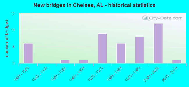
- New bridges - historical statistics
- 61930-1939
- 11950-1959
- 11960-1969
- 91970-1979
- 61980-1989
- 81990-1999
- 122000-2009
- 12010-2019
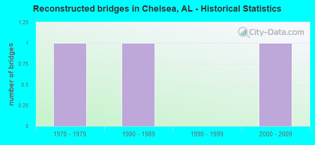
- Reconstructed bridges - Historical Statistics
- 11970-1979
- 11980-1989
- 01990-1999
- 12000-2009
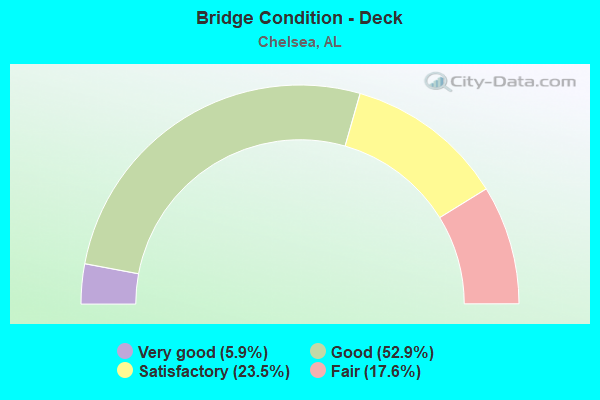
- Bridge Condition - Deck
- 5.9%Very good
- 52.9%Good
- 23.5%Satisfactory
- 17.6%Fair
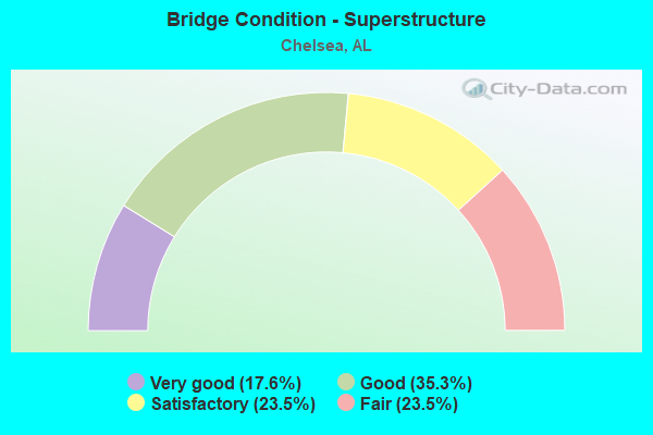
- Bridge Condition - Superstructure
- 17.6%Very good
- 35.3%Good
- 23.5%Satisfactory
- 23.5%Fair
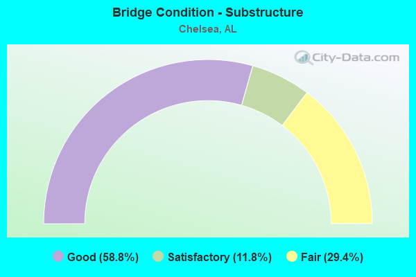
- Bridge Condition - Substructure
- 58.8%Good
- 11.8%Satisfactory
- 29.4%Fair
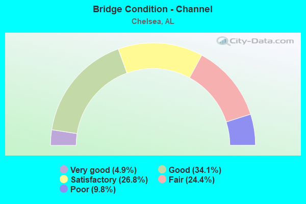
- Bridge Condition - Channel
- 4.9%Very good
- 34.1%Good
- 26.8%Satisfactory
- 24.4%Fair
- 9.8%Poor
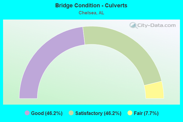
- Bridge Condition - Culverts
- 46.2%Good
- 46.2%Satisfactory
- 7.7%Fair
Find on map >> Show street view
Structure Number: 21463, Location: _0.9 MI. South CR 439 (Lat: 33.339500, Lng: -86.597800), Route carried "on" structure: City street , Year Built: 2018, Status: Open, Structure Length: 1.13m (3.71ft), Average Daily Traffic: 25 (year 2020), Average Future Daily Traffic: 35 (year 2040), Design Load: HS 20, Features Intersected: _Little Creek, Facility Carried by Structure: _Liberty Road
Minimum Vertical Clearance: 30+ m (98+ ft), Kilometerpoint: 0.000, Lanes on structure: 2, Owner: County Highway Agency, Approaching Roadway Width: 4.9m (16.1ft), Material/Design: Concrete, Design/Construction: Culvert, Number Of Spans In Main Unit: 4, Length of Maximum Span: 2.4m (7.9ft), Out-to-Out Width: 7.3m (24.0ft)
Condition: Channel: Good, Culverts: Good, Operating Rating: 47.4 metric tons, Method Used To Determine Operating Rating: Load Factor (LF), Inventory Rating: 28.4 metric tons, Method Used To Determine Inventory Rating: Load Factor (LF), Structural Evaluation: Better than present minimum criteria, Waterway Adequacy: Meets minimum limits, Approach Roadway Alignment: Equal to present minimum criteria, Length Of Structure Improvement: 1.81m (5.94ft), Designated Inspection Frequency: Every 24 months, Inspection Date: October 2020, Bridge Improvement Cost: $250,000, Roadway Improvement Cost: $25,000, Total Project Cost: $275,000 ( Estimate for 2022)
Find on map >> Show street view
Structure Number: 19851, Location: CR 280 0.5 MI. W. CR 47 (Lat: 33.347028, Lng: -86.639222), Route carried "under" structure: County highway 280, Year Built: 1950, Structure Length: 0. m, Average Daily Traffic: 1,900 (year 2007), Truck Traffic: 5%, Features Intersected: CR 280, Facility Carried by Structure: CSX RR
Minimum Vertical Clearance: 4.24m (13.91ft), Kilometerpoint: 0.000, Lanes under structure: 1, Material/Design: Steel, Design/Construction: Stringer/Multi-beam, Length of Maximum Span: 0.0m