Bridge Statistics for Chesterfield, Missouri (MO)
Condition, Traffic, Stress, Structural Evaluation, Project Costs
- National Bridge Inventory (NBI) Statistics
- 66Number of bridges
- 863ft / 263mTotal length
- $4,644,000Total costs
- 1,379,544Total average daily traffic
- 120,133Total average daily truck traffic
- National Bridge Inventory (NBI) Registered Bridges for Chesterfield
- No street view available for this location
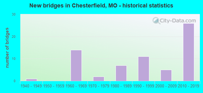
- New bridges - historical statistics
- 11940-1949
- 141960-1969
- 21970-1979
- 71980-1989
- 111990-1999
- 52000-2009
- 262010-2019
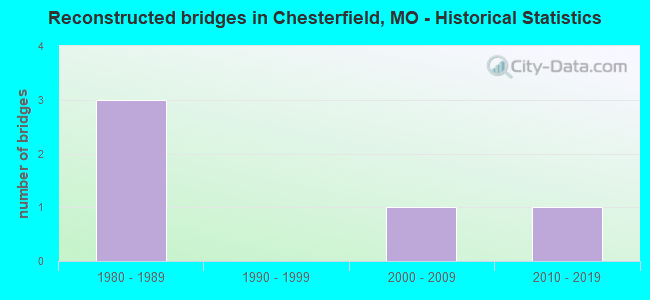
- Reconstructed bridges - Historical Statistics
- 31980-1989
- 01990-1999
- 12000-2009
- 12010-2019
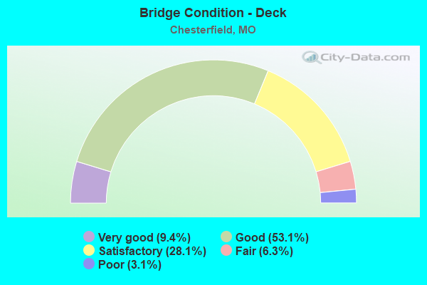
- Bridge Condition - Deck
- 9.4%Very good
- 53.1%Good
- 28.1%Satisfactory
- 6.3%Fair
- 3.1%Poor
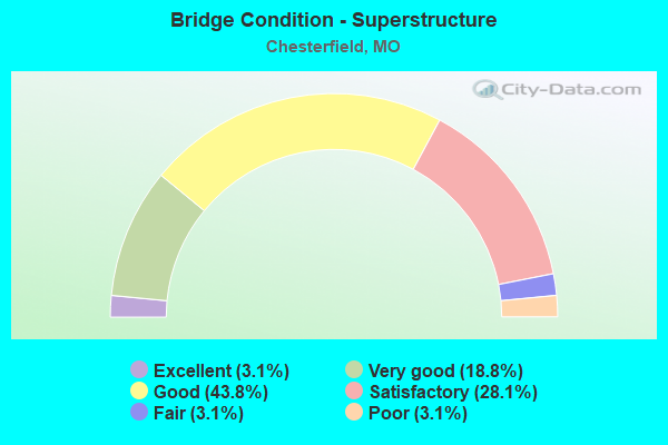
- Bridge Condition - Superstructure
- 3.1%Excellent
- 18.8%Very good
- 43.8%Good
- 28.1%Satisfactory
- 3.1%Fair
- 3.1%Poor
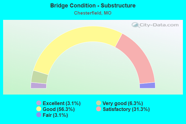
- Bridge Condition - Substructure
- 3.1%Excellent
- 6.3%Very good
- 56.3%Good
- 31.3%Satisfactory
- 3.1%Fair
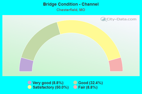
- Bridge Condition - Channel
- 8.8%Very good
- 32.4%Good
- 50.0%Satisfactory
- 8.8%Fair
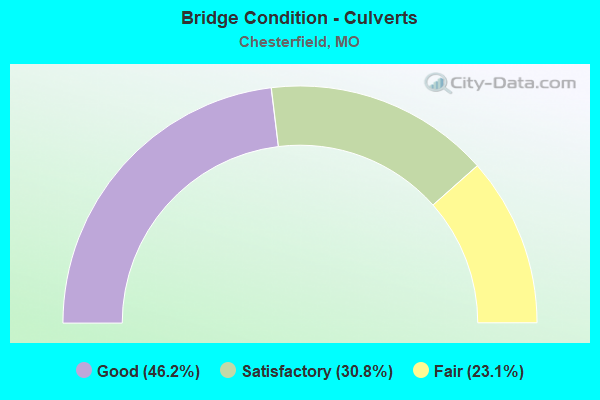
- Bridge Condition - Culverts
- 46.2%Good
- 30.8%Satisfactory
- 23.1%Fair
Find on map >> Show street view
Structure Number: 3907, Location: S 13 T 45 N R 4 E (Lat: 38.645878, Lng: -90.527372), Route carried "on" structure: ServiceState highway 64, Year Built: 1990, Status: Open, Structure Length: 5.49m (18.01ft), Average Daily Traffic: 5,122 (year 2021), Truck Traffic: 3%, Average Future Daily Traffic: 7,683 (year 2041), Design Load: HS 20+Mod, Features Intersected: CREVE COEUR CR
Minimum Vertical Clearance: 30+ m (98+ ft), Kilometerpoint: 2.097, Lanes on structure: 2, Owner: State Highway Agency, Approaching Roadway Width: 11.0m (36.1ft), Skew: 4 degrees, Material/Design: Prestressed concrete continuous, Design/Construction: Tee Beam, Number Of Spans In Main Unit: 5, Length of Maximum Span: 11.3m (37.1ft), Curb or Sidewalk Widths: Left: 0.2m (0.7ft), Right: 0.2m (0.7ft), Curb-To-Curb Width: 10.6m (34.8ft), Out-to-Out Width: 11.4m (37.4ft)
Condition: Deck: Good, Superstructure: Satisfactory, Substructure: Satisfactory, Channel: Satisfactory, Operating Rating: 49.5 metric tons, Method Used To Determine Operating Rating: Allowable Stress (AS), Inventory Rating: 38.7 metric tons, Method Used To Determine Inventory Rating: Allowable Stress (AS), Structural Evaluation: Equal to present minimum criteria, Deck Geometry: Somewhat better than minimum adequacy, Waterway Adequacy: Superior to present desirable criteria, Approach Roadway Alignment: Equal to present desirable criteria, Designated Inspection Frequency: Every 24 months, Inspection Date: October 2020, Deck Structure Type: Concrete Cast-file-Place, Wearing Surface/Protective System: Wearing Surface: Monolithic Concrete, Deck Protection: Epoxy Coated Reinforcing
Find on map >> Show street view
Structure Number: 606, Location: S 297 T 46 N R 2 E (Lat: 38.745253, Lng: -90.762069), Route carried "on" structure: State highway DD, Year Built: 1943, Status: Open, Structure Length: 1.00m (3.28ft), Average Daily Traffic: 8,840 (year 2021), Truck Traffic: 10%, Average Future Daily Traffic: 17,238 (year 2041), Design Load: H 15, Features Intersected: BALL RIDGE BR
Minimum Vertical Clearance: 30+ m (98+ ft), Kilometerpoint: 0.964, Lanes on structure: 2, Owner: State Highway Agency, Approaching Roadway Width: 7.3m (24.0ft), Skew: 4 degrees, Material/Design: Concrete continuous, Design/Construction: Culvert, Number Of Spans In Main Unit: 2, Length of Maximum Span: 3.7m (12.1ft), Curb-To-Curb Width: 8.7m (28.5ft), Out-to-Out Width: 9.1m (29.9ft)
Condition: Channel: Fair, Culverts: Good, Operating Rating: 93.6 metric tons, Method Used To Determine Operating Rating: Load Factor (LF), Inventory Rating: 56.7 metric tons, Method Used To Determine Inventory Rating: Load Factor (LF), Structural Evaluation: Better than present minimum criteria, Deck Geometry: High priority of replacement, Waterway Adequacy: Better than present minimum criteria, Approach Roadway Alignment: Equal to present minimum criteria, Length Of Structure Improvement: 0.17m (0.56ft), Designated Inspection Frequency: Every 24 months, Inspection Date: November 2021, Bridge Improvement Cost: $170,000, Roadway Improvement Cost: $17,000, Total Project Cost: $255,000 ( Estimate for 2022)
Find on map >> Show street view
Structure Number: 7435, Location: S 12 T 49 N R 16 W (Lat: 39.050500, Lng: -92.674975), Route carried "on" structure: State highway P, Year Built: 1961, Year Reconstructed: 2009, Status: Open, Structure Length: 4.54m (14.90ft), Average Daily Traffic: 177 (year 2021), Truck Traffic: 10%, Average Future Daily Traffic: 221 (year 2041), Design Load: H 15, Features Intersected: SALT CR
Minimum Vertical Clearance: 30+ m (98+ ft), Kilometerpoint: 7.593, Lanes on structure: 2, Owner: State Highway Agency, Approaching Roadway Width: 6.7m (22.0ft), Material/Design: Steel, Design/Construction: Stringer/Multi-beam, Number Of Spans In Main Unit: 3, Length of Maximum Span: 15.3m (50.2ft), Curb-To-Curb Width: 6.7m (22.0ft), Out-to-Out Width: 7.5m (24.6ft)
Condition: Deck: Very good, Superstructure: Satisfactory, Substructure: Good, Channel: Satisfactory, Operating Rating: 56.7 metric tons, Method Used To Determine Operating Rating: Load Factor (LF), Inventory Rating: 34.2 metric tons, Method Used To Determine Inventory Rating: Load Factor (LF), Structural Evaluation: Equal to present minimum criteria, Deck Geometry: Meets minimum limits, Waterway Adequacy: Equal to present minimum criteria, Approach Roadway Alignment: Equal to present desirable criteria, Designated Inspection Frequency: Every 24 months, Inspection Date: June 2021, Deck Structure Type: Concrete Cast-file-Place, Wearing Surface/Protective System: Wearing Surface: Monolithic Concrete, Deck Protection: Epoxy Coated Reinforcing
Find on map >> Show street view
Structure Number: 11831, Location: S 125 T 45 N R 4 E (Lat: 38.670569, Lng: -90.599650), Route carried "under" structure: Interstate 64, Year Built: 1999, Structure Length: 0. m, Average Daily Traffic: 43,820 (year 2021), Truck Traffic: 11%, Features Intersected: IS 64, Facility Carried by Structure: BOONES CROSSING RD
Minimum Vertical Clearance: 5.36m (17.59ft), Kilometerpoint: 27.600, Lanes on structure: 7, Lanes under structure: 3, Material/Design: Prestressed concrete continuous, Design/Construction: Stringer/Multi-beam, Length of Maximum Span: 20.4m (66.9ft)
Find on map >> Show street view
Structure Number: 11831, Location: S 125 T 45 N R 4 E (Lat: 38.670569, Lng: -90.599650), Route carried "under" structure: Interstate 64, Year Built: 1999, Structure Length: 0. m, Average Daily Traffic: 48,507 (year 2021), Truck Traffic: 8%, Features Intersected: IS 64, Facility Carried by Structure: BOONES CROSSING RD
Minimum Vertical Clearance: 5.44m (17.85ft), Kilometerpoint: 38.098, Lanes on structure: 7, Lanes under structure: 3, Material/Design: Prestressed concrete continuous, Design/Construction: Stringer/Multi-beam, Length of Maximum Span: 20.4m (66.9ft)
Find on map >> Show street view
Structure Number: 1372, Location: S 415 T 45 N R 4 E (Lat: 38.652958, Lng: -90.558458), Route carried "under" structure: State highway 340, Year Built: 1968, Structure Length: 0. m, Average Daily Traffic: 14,674 (year 2021), Truck Traffic: 5%, Features Intersected: MO 340, Facility Carried by Structure: IS 64 E
Minimum Vertical Clearance: 4.83m (15.85ft), Kilometerpoint: 7.389, Lanes on structure: 3, Lanes under structure: 4, Material/Design: Concrete continuous, Design/Construction: Slab, Length of Maximum Span: 21.3m (69.9ft)
Find on map >> Show street view
Structure Number: 1372, Location: S 415 T 45 N R 4 E (Lat: 38.652958, Lng: -90.558458), Route carried "under" structure: State highway 340, Year Built: 1968, Structure Length: 0. m, Average Daily Traffic: 9,657 (year 2021), Truck Traffic: 5%, Features Intersected: MO 340, Facility Carried by Structure: IS 64 E
Minimum Vertical Clearance: 4.83m (15.85ft), Kilometerpoint: 23.632, Lanes on structure: 3, Lanes under structure: 2, Material/Design: Concrete continuous, Design/Construction: Slab, Length of Maximum Span: 21.3m (69.9ft)
Find on map >> Show street view
Structure Number: 1373, Location: S 415 T 45 N R 4 E (Lat: 38.653053, Lng: -90.558331), Route carried "under" structure: State highway 340, Year Built: 1968, Structure Length: 0. m, Average Daily Traffic: 9,171 (year 2021), Truck Traffic: 5%, Features Intersected: MO 340, Facility Carried by Structure: IS 64 W
Minimum Vertical Clearance: 4.83m (15.85ft), Kilometerpoint: 7.405, Lanes on structure: 3, Lanes under structure: 2, Material/Design: Concrete continuous, Design/Construction: Slab, Length of Maximum Span: 21.3m (69.9ft)
Find on map >> Show street view
Structure Number: 1373, Location: S 415 T 45 N R 4 E (Lat: 38.653053, Lng: -90.558331), Route carried "under" structure: State highway 340, Year Built: 1968, Structure Length: 0. m, Average Daily Traffic: 9,657 (year 2021), Truck Traffic: 5%, Features Intersected: MO 340, Facility Carried by Structure: IS 64 W
Minimum Vertical Clearance: 4.83m (15.85ft), Kilometerpoint: 23.617, Lanes on structure: 3, Lanes under structure: 4, Material/Design: Concrete continuous, Design/Construction: Slab, Length of Maximum Span: 21.3m (69.9ft)
Find on map >> Show street view
Structure Number: 1852, Location: S 371 T 45 N R 3 E (Lat: 38.674539, Lng: -90.645581), Route carried "under" structure: Interstate 64, Year Built: 1968, Structure Length: 0. m, Average Daily Traffic: 43,658 (year 2021), Truck Traffic: 11%, Features Intersected: IS 64, Facility Carried by Structure: SPIRIT OF ST LOUIS
Minimum Vertical Clearance: 5.03m (16.50ft), Kilometerpoint: 23.579, Lanes on structure: 3, Lanes under structure: 3, Material/Design: Steel continuous, Design/Construction: Stringer/Multi-beam, Length of Maximum Span: 26.2m (86.0ft)
Find on map >> Show street view
Structure Number: 1852, Location: S 371 T 45 N R 3 E (Lat: 38.674539, Lng: -90.645581), Route carried "under" structure: Interstate 64, Year Built: 1968, Structure Length: 0. m, Average Daily Traffic: 43,700 (year 2021), Truck Traffic: 8%, Features Intersected: IS 64, Facility Carried by Structure: SPIRIT OF ST LOUIS
Minimum Vertical Clearance: 5.03m (16.50ft), Kilometerpoint: 42.120, Lanes on structure: 3, Lanes under structure: 3, Material/Design: Steel continuous, Design/Construction: Stringer/Multi-beam, Length of Maximum Span: 26.2m (86.0ft)
Find on map >> Show street view
Structure Number: 1853, Location: S 126 T 45 N R 4 E (Lat: 38.671956, Lng: -90.616992), Route carried "under" structure: Interstate 64, Year Built: 1968, Structure Length: 0. m, Average Daily Traffic: 43,658 (year 2021), Truck Traffic: 11%, Features Intersected: IS 64
Minimum Vertical Clearance: 4.65m (15.26ft), Kilometerpoint: 26.078, Lanes on structure: 1, Lanes under structure: 3, Material/Design: Concrete continuous, Design/Construction: Box Beam or Girders - Single/Spread, Length of Maximum Span: 28.3m (92.8ft)
Find on map >> Show street view
Structure Number: 1853, Location: S 126 T 45 N R 4 E (Lat: 38.671956, Lng: -90.616992), Route carried "under" structure: Interstate 64, Year Built: 1968, Structure Length: 0. m, Average Daily Traffic: 48,507 (year 2021), Truck Traffic: 8%, Features Intersected: IS 64
Minimum Vertical Clearance: 4.60m (15.09ft), Kilometerpoint: 39.609, Lanes on structure: 1, Lanes under structure: 3, Material/Design: Concrete continuous, Design/Construction: Box Beam or Girders - Single/Spread, Length of Maximum Span: 28.3m (92.8ft)
Find on map >> Show street view
Structure Number: 32944, Location: S 109 T 45 N R 5 E (Lat: 38.660556, Lng: -90.504722), Route carried "under" structure: City street , Year Built: 2012, Structure Length: 0. m, Average Daily Traffic: 6,171 (year 2021), Truck Traffic: 4%, Features Intersected: CST N WOODS MILL RD, Facility Carried by Structure: RT AB E
Minimum Vertical Clearance: 4.90m (16.08ft), Kilometerpoint: 2.250, Lanes on structure: 6, Lanes under structure: 2, Material/Design: Prestressed concrete, Design/Construction: Tee Beam, Length of Maximum Span: 38.1m (125.0ft)
Find on map >> Show street view
Structure Number: 32973, Location: S 367 T 46 N R 5 E (Lat: 38.681358, Lng: -90.493358), Route carried "under" structure: State highway 141, Year Built: 2011, Structure Length: 0. m, Average Daily Traffic: 17,817 (year 2021), Truck Traffic: 5%, Features Intersected: MO 141, Facility Carried by Structure: MO 340 E
Minimum Vertical Clearance: 5.49m (18.01ft), Kilometerpoint: 14.895, Lanes on structure: 8, Lanes under structure: 2, Material/Design: Prestressed concrete, Design/Construction: Stringer/Multi-beam, Length of Maximum Span: 28.7m (94.2ft)
Find on map >> Show street view
Structure Number: 32973, Location: S 367 T 46 N R 5 E (Lat: 38.681358, Lng: -90.493358), Route carried "under" structure: State highway 141, Year Built: 2011, Structure Length: 0. m, Average Daily Traffic: 6,126 (year 2021), Truck Traffic: 5%, Features Intersected: MO 141, Facility Carried by Structure: MO 340 E
Minimum Vertical Clearance: 5.18m (16.99ft), Kilometerpoint: 34.773, Lanes on structure: 8, Lanes under structure: 2, Material/Design: Prestressed concrete, Design/Construction: Stringer/Multi-beam, Length of Maximum Span: 28.7m (94.2ft)
Find on map >> Show street view
Structure Number: 3449, Location: S 371 T 45 N R 3 E (Lat: 38.676389, Lng: -90.656389), Route carried "under" structure: Interstate 64, Year Built: 2013, Structure Length: 0. m, Average Daily Traffic: 43,658 (year 2021), Truck Traffic: 11%, Features Intersected: IS 64, Facility Carried by Structure: RP CHESTERFIELD AI
Minimum Vertical Clearance: 5.77m (18.93ft), Kilometerpoint: 22.600, Lanes on structure: 1, Lanes under structure: 3, Material/Design: Prestressed concrete continuous, Design/Construction: Tee Beam, Length of Maximum Span: 26.8m (87.9ft)
Find on map >> Show street view
Structure Number: 3449, Location: S 371 T 45 N R 3 E (Lat: 38.676389, Lng: -90.656389), Route carried "under" structure: Interstate 64, Year Built: 2013, Structure Length: 0. m, Average Daily Traffic: 43,700 (year 2021), Truck Traffic: 8%, Features Intersected: IS 64, Facility Carried by Structure: RP CHESTERFIELD AI
Minimum Vertical Clearance: 5.72m (18.77ft), Kilometerpoint: 43.097, Lanes on structure: 1, Lanes under structure: 3, Material/Design: Prestressed concrete continuous, Design/Construction: Tee Beam, Length of Maximum Span: 26.8m (87.9ft)
Find on map >> Show street view
Structure Number: 34573, Location: S 123 T 45 N R 4 E (Lat: 38.658942, Lng: -90.566889), Route carried "under" structure: Interstate 64, Year Built: 2013, Structure Length: 0. m, Average Daily Traffic: 43,820 (year 2021), Truck Traffic: 11%, Features Intersected: IS 64, Facility Carried by Structure: CHESTERFIELD PKWY
Minimum Vertical Clearance: 5.27m (17.29ft), Kilometerpoint: 30.933, Lanes on structure: 7, Lanes under structure: 3, Material/Design: Prestressed concrete continuous, Design/Construction: Tee Beam, Length of Maximum Span: 23.2m (76.1ft)
Find on map >> Show street view
Structure Number: 34573, Location: S 123 T 45 N R 4 E (Lat: 38.658942, Lng: -90.566889), Route carried "under" structure: Interstate 64, Year Built: 2013, Structure Length: 0. m, Average Daily Traffic: 48,507 (year 2021), Truck Traffic: 8%, Features Intersected: IS 64, Facility Carried by Structure: CHESTERFIELD PKWY
Minimum Vertical Clearance: 6.25m (20.51ft), Kilometerpoint: 34.754, Lanes on structure: 7, Lanes under structure: 3, Material/Design: Prestressed concrete continuous, Design/Construction: Tee Beam, Length of Maximum Span: 23.2m (76.1ft)
Find on map >> Show street view
Structure Number: 3842, Location: S 10 T 45 N R 4 E (Lat: 38.650703, Lng: -90.550292), Route carried "under" structure: Interstate 64, Year Built: 1990, Structure Length: 0. m, Average Daily Traffic: 63,620 (year 2021), Truck Traffic: 8%, Features Intersected: IS 64, Facility Carried by Structure: CHESTERFIELD PKWY
Minimum Vertical Clearance: 5.00m (16.40ft), Kilometerpoint: 32.993, Lanes on structure: 6, Lanes under structure: 4, Material/Design: Steel continuous, Design/Construction: Stringer/Multi-beam, Length of Maximum Span: 34.1m (111.9ft)
Find on map >> Show street view
Structure Number: 3842, Location: S 10 T 45 N R 4 E (Lat: 38.650703, Lng: -90.550292), Route carried "under" structure: Interstate 64, Year Built: 1990, Structure Length: 0. m, Average Daily Traffic: 63,579 (year 2021), Truck Traffic: 11%, Features Intersected: IS 64, Facility Carried by Structure: CHESTERFIELD PKWY
Minimum Vertical Clearance: 4.98m (16.34ft), Kilometerpoint: 32.695, Lanes on structure: 6, Lanes under structure: 4, Material/Design: Steel continuous, Design/Construction: Stringer/Multi-beam, Length of Maximum Span: 34.1m (111.9ft)
Find on map >> Show street view
Structure Number: 3843, Location: S 11 T 45 N R 4 E (Lat: 38.646722, Lng: -90.530339), Route carried "under" structure: Interstate 64, Year Built: 1990, Structure Length: 0. m, Average Daily Traffic: 63,579 (year 2021), Truck Traffic: 11%, Features Intersected: IS 64, Facility Carried by Structure: TIMBERLAKE MANOR D
Minimum Vertical Clearance: 5.16m (16.93ft), Kilometerpoint: 34.490, Lanes on structure: 6, Lanes under structure: 3, Material/Design: Steel continuous, Design/Construction: Stringer/Multi-beam, Length of Maximum Span: 29.6m (97.1ft)
Find on map >> Show street view
Structure Number: 3843, Location: S 11 T 45 N R 4 E (Lat: 38.646722, Lng: -90.530339), Route carried "under" structure: Interstate 64, Year Built: 1990, Structure Length: 0. m, Average Daily Traffic: 63,620 (year 2021), Truck Traffic: 8%, Features Intersected: IS 64, Facility Carried by Structure: TIMBERLAKE MANOR D
Minimum Vertical Clearance: 5.11m (16.77ft), Kilometerpoint: 31.202, Lanes on structure: 6, Lanes under structure: 3, Material/Design: Steel continuous, Design/Construction: Stringer/Multi-beam, Length of Maximum Span: 29.6m (97.1ft)