Bridge Statistics for Chesterton, Indiana (IN)
Condition, Traffic, Stress, Structural Evaluation, Project Costs
- National Bridge Inventory (NBI) Statistics
- 99Number of bridges
- 850ft / 259mTotal length
- $10,526,000Total costs
- 923,130Total average daily traffic
- 157,340Total average daily truck traffic
- National Bridge Inventory (NBI) Registered Bridges for Chesterton
- No street view available for this location
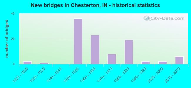
- New bridges - historical statistics
- 21920-1929
- 11930-1939
- 361950-1959
- 231960-1969
- 81970-1979
- 191980-1989
- 21990-1999
- 22000-2009
- 62010-2019

- Reconstructed bridges - Historical Statistics
- 61980-1989
- 71990-1999
- 112000-2009
- 102010-2019


- Bridge Condition - Deck
- 8.8%Very good
- 43.9%Good
- 28.1%Satisfactory
- 14.0%Fair
- 5.3%Poor

- Bridge Condition - Superstructure
- 21.1%Very good
- 40.4%Good
- 22.8%Satisfactory
- 10.5%Fair
- 5.3%Poor

- Bridge Condition - Substructure
- 14.0%Very good
- 45.6%Good
- 28.1%Satisfactory
- 7.0%Fair
- 5.3%Poor

- Bridge Condition - Channel
- 8.6%Very good
- 31.4%Good
- 31.4%Satisfactory
- 22.9%Fair
- 5.7%Poor

- Bridge Condition - Culverts
- 25.0%Very good
- 25.0%Good
- 37.5%Satisfactory
- 12.5%Fair
Find on map >> Show street view
Structure Number: 4706, Location: 02.94 E SR 49 (Lat: 41.570431, Lng: -86.989264), Route carried "under" structure: County highway 400, Year Built: 1956, Structure Length: 0. m, Average Daily Traffic: 1,328 (year 2014), Truck Traffic: 10%, Features Intersected: CR 400 E, Facility Carried by Structure: I-90 EB
Minimum Vertical Clearance: 4.22m (13.85ft), Kilometerpoint: 0.000, Lanes on structure: 2, Lanes under structure: 2, Toll: On toll road, Material/Design: Steel, Design/Construction: Stringer/Multi-beam, Length of Maximum Span: 10.1m (33.1ft)
Find on map >> Show street view
Structure Number: 4707, Location: 02.94 E SR 49 (Lat: 41.570650, Lng: -86.989264), Route carried "under" structure: County highway 400, Year Built: 1956, Structure Length: 0. m, Average Daily Traffic: 1,328 (year 2014), Truck Traffic: 10%, Features Intersected: CR 400 E, Facility Carried by Structure: I-90 WB
Minimum Vertical Clearance: 4.27m (14.01ft), Kilometerpoint: 0.000, Lanes on structure: 2, Lanes under structure: 2, Toll: On toll road, Material/Design: Steel, Design/Construction: Stringer/Multi-beam, Length of Maximum Span: 10.1m (33.1ft)
Find on map >> Show street view
Structure Number: 4922, Location: 02.11 E SR 49 (Lat: 41.635000, Lng: -87.008331), Route carried "under" structure: Interstate 94, Year Built: 1969, Structure Length: 0. m, Average Daily Traffic: 16,890 (year 2004), Truck Traffic: 20%, Features Intersected: I-94 EB, Facility Carried by Structure: BRUMMITT ROAD
Minimum Vertical Clearance: 5.31m (17.42ft), Kilometerpoint: 45.029, Lanes on structure: 2, Lanes under structure: 3, Material/Design: Steel continuous, Design/Construction: Stringer/Multi-beam, Length of Maximum Span: 34.1m (111.9ft)
Find on map >> Show street view
Structure Number: 4922, Location: 02.11 E SR 49 (Lat: 41.635000, Lng: -87.008331), Route carried "under" structure: Interstate 94, Year Built: 1969, Structure Length: 0. m, Average Daily Traffic: 16,890 (year 2004), Truck Traffic: 20%, Features Intersected: I-94 WB, Facility Carried by Structure: BRUMMITT ROAD
Minimum Vertical Clearance: 5.31m (17.42ft), Kilometerpoint: 45.029, Lanes on structure: 2, Lanes under structure: 3, Material/Design: Steel continuous, Design/Construction: Stringer/Multi-beam, Length of Maximum Span: 34.1m (111.9ft)