Bridge Statistics for Cheyenne, Wyoming (WY)
Condition, Traffic, Stress, Structural Evaluation, Project Costs
- National Bridge Inventory (NBI) Statistics
- 148Number of bridges
- 1,752ft / 534mTotal length
- $3,857,000Total costs
- 1,186,313Total average daily traffic
- 265,185Total average daily truck traffic
- National Bridge Inventory (NBI) Registered Bridges for Cheyenne
- No street view available for this location
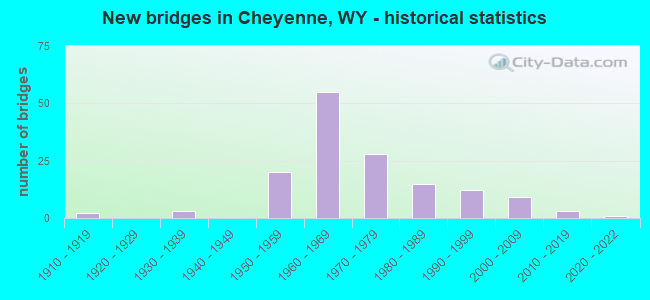
- New bridges - historical statistics
- 21910-1919
- 31930-1939
- 201950-1959
- 551960-1969
- 281970-1979
- 151980-1989
- 121990-1999
- 92000-2009
- 32010-2019
- 12020-2022
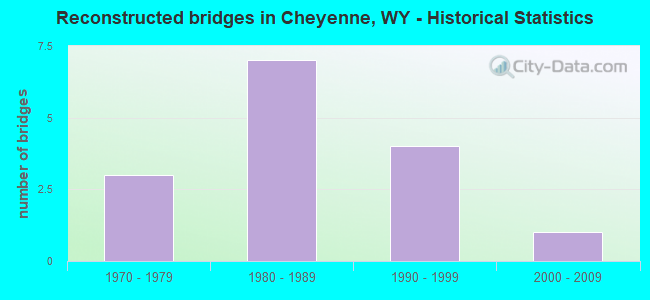
- Reconstructed bridges - Historical Statistics
- 31970-1979
- 71980-1989
- 41990-1999
- 12000-2009
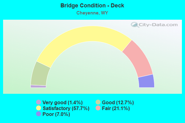
- Bridge Condition - Deck
- 1.4%Very good
- 12.7%Good
- 57.7%Satisfactory
- 21.1%Fair
- 7.0%Poor
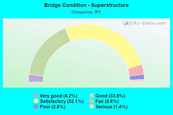
- Bridge Condition - Superstructure
- 4.2%Very good
- 33.8%Good
- 52.1%Satisfactory
- 5.6%Fair
- 2.8%Poor
- 1.4%Serious
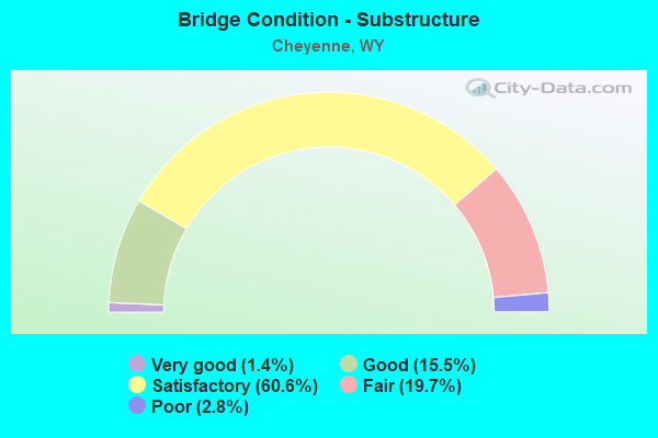
- Bridge Condition - Substructure
- 1.4%Very good
- 15.5%Good
- 60.6%Satisfactory
- 19.7%Fair
- 2.8%Poor
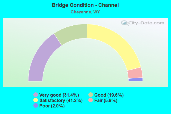
- Bridge Condition - Channel
- 31.4%Very good
- 19.6%Good
- 41.2%Satisfactory
- 5.9%Fair
- 2.0%Poor
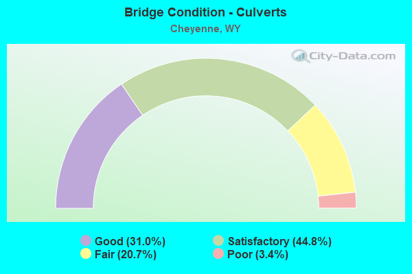
- Bridge Condition - Culverts
- 31.0%Good
- 44.8%Satisfactory
- 20.7%Fair
- 3.4%Poor
Find on map >> Show street view
Structure Number: CGC, Location: Cheyenne - Pine Bluffs (Lat: 41.157456, Lng: -104.655758), Route carried "on" structure: US 30, Year Built: 1976, Status: Open, Structure Length: 9.91m (32.51ft), Average Daily Traffic: 2,352 (year 2021), Truck Traffic: 6%, Average Future Daily Traffic: 3,293 (year 2041), Design Load: HS 20+Mod, Features Intersected: I-80
Minimum Vertical Clearance: 30+ m (98+ ft), Kilometerpoint: 597.419, Lanes on structure: 2, Lanes under structure: 4, Base Highway Network: Yes, Owner: State Highway Agency, Approaching Roadway Width: 9.8m (32.2ft), Material/Design: Concrete continuous, Design/Construction: Box Beam or Girders - Multiple, Number Of Spans In Main Unit: 2, Length of Maximum Span: 48.8m (160.1ft), Curb-To-Curb Width: 9.8m (32.2ft), Out-to-Out Width: 10.6m (34.8ft)
Condition: Deck: Good, Superstructure: Fair, Substructure: Satisfactory, Operating Rating: 99.8 metric tons, Method Used To Determine Operating Rating: Load Factor (LF), Inventory Rating: 59.9 metric tons, Method Used To Determine Inventory Rating: Load Factor (LF), Structural Evaluation: Somewhat better than minimum adequacy, Deck Geometry: Meets minimum limits, Underclear: Superior to present desirable criteria, Approach Roadway Alignment: Equal to present desirable criteria, Designated Inspection Frequency: Every 24 months, Inspection Date: Febuary 2021, Deck Structure Type: Concrete Cast-file-Place, Wearing Surface/Protective System: Wearing Surface: Latex Concrete
Find on map >> Show street view
Structure Number: CTU, Location: Missile Drive Cheyenne (Lat: 41.132844, Lng: -104.832983), Route carried "on" structure: City street 4044, Year Built: 1961, Status: Open, Structure Length: 2.55m (8.37ft), Average Daily Traffic: 3,781 (year 2021), Truck Traffic: 8%, Average Future Daily Traffic: 5,293 (year 2041), Design Load: HS 20, Features Intersected: Crow Creek, Facility Carried by Structure: Missile Drive
Minimum Vertical Clearance: 5.19m (17.03ft), Kilometerpoint: 162.969, Lanes on structure: 4, Owner: Town or Township Highway Agency, Approaching Roadway Width: 7.9m (25.9ft), Skew: 14 degrees, Material/Design: Concrete continuous, Design/Construction: Culvert, Number Of Spans In Main Unit: 4, Length of Maximum Span: 4.6m (15.1ft), Curb-To-Curb Width: 7.9m (25.9ft), Out-to-Out Width: 21.0m (68.9ft)
Condition: Channel: Satisfactory, Culverts: Fair, Operating Rating: 78.7 metric tons, Method Used To Determine Operating Rating: Load Factor (LF), Inventory Rating: 47.0 metric tons, Method Used To Determine Inventory Rating: Load Factor (LF), Structural Evaluation: Somewhat better than minimum adequacy, Deck Geometry: High priority of replacement, Waterway Adequacy: Equal to present desirable criteria, Approach Roadway Alignment: Equal to present desirable criteria, Length Of Structure Improvement: 9.54m (31.30ft), Designated Inspection Frequency: Every 24 months, Inspection Date: December 2021, Bridge Improvement Cost: $45,000, Roadway Improvement Cost: $30,000, Total Project Cost: $98,000, Deck Structure Type: Concrete Cast-file-Place, Wearing Surface/Protective System: Wearing Surface: Bituminous
Find on map >> Show street view
Structure Number: CYD, Location: Jct I-25 - Jct Us 85 (Lat: 41.039722, Lng: -104.884758), Route carried "on" structure: State highway 223, Year Built: 1934, Status: Open, Structure Length: 3.32m (10.89ft), Average Daily Traffic: 485 (year 2021), Truck Traffic: 5%, Average Future Daily Traffic: 679 (year 2041), Design Load: H 15, Features Intersected: UPRR
Minimum Vertical Clearance: 30+ m (98+ ft), Kilometerpoint: 1.342, Lanes on structure: 2, Owner: State Highway Agency, Approaching Roadway Width: 6.7m (22.0ft), Material/Design: Steel, Design/Construction: Stringer/Multi-beam, Number Of Spans In Main Unit: 3, Length of Maximum Span: 12.8m (42.0ft), Curb or Sidewalk Widths: Left: 0.2m (0.7ft), Right: 0.2m (0.7ft), Curb-To-Curb Width: 7.3m (24.0ft), Out-to-Out Width: 8.2m (26.9ft)
Condition: Deck: Poor, Superstructure: Satisfactory, Substructure: Fair, Operating Rating: 51.3 metric tons, Method Used To Determine Operating Rating: Load Factor (LF), Inventory Rating: 24.9 metric tons, Method Used To Determine Inventory Rating: Load Factor (LF), Structural Evaluation: Somewhat better than minimum adequacy, Deck Geometry: Meets minimum limits, Underclear: Better than present minimum criteria, Approach Roadway Alignment: Equal to present desirable criteria, Length Of Structure Improvement: 4.18m (13.71ft), Designated Inspection Frequency: Every 24 months, Inspection Date: Febuary 2021, Bridge Improvement Cost: $216,000, Roadway Improvement Cost: $22,000, Total Project Cost: $324,000 ( Estimate for 2014), Deck Structure Type: Concrete Cast-file-Place, Wearing Surface/Protective System: Wearing Surface: Bituminous
Find on map >> Show street view
Structure Number: DBN, Location: Cheyenne (Lat: 41.124292, Lng: -104.748117), Route carried "on" structure: Interstate 80, Year Built: 1976, Status: Open, Structure Length: 8.11m (26.61ft), Average Daily Traffic: 7,169 (year 2021), Truck Traffic: 78%, Average Future Daily Traffic: 10,037 (year 2041), Design Load: HS 20+Mod, Features Intersected: Burlington Trail Road
Minimum Vertical Clearance: 30+ m (98+ ft), Kilometerpoint: 587.113, Lanes on structure: 2, Lanes under structure: 2, Base Highway Network: Yes (Inventory Route: ML8, Subroute: 4), Owner: State Highway Agency, Approaching Roadway Width: 12.2m (40.0ft), Skew: 14 degrees, Material/Design: Steel continuous, Design/Construction: Stringer/Multi-beam, Number Of Spans In Main Unit: 3, Length of Maximum Span: 31.7m (104.0ft), Curb-To-Curb Width: 12.8m (42.0ft), Out-to-Out Width: 13.6m (44.6ft)
Condition: Deck: Good, Superstructure: Good, Substructure: Satisfactory, Operating Rating: 55.5 metric tons, Method Used To Determine Operating Rating: Load Factor (LF), Inventory Rating: 33.3 metric tons, Method Used To Determine Inventory Rating: Load Factor (LF), Structural Evaluation: Equal to present minimum criteria, Deck Geometry: Equal to present desirable criteria, Underclear: High priority of corrective action, Approach Roadway Alignment: Equal to present desirable criteria, Designated Inspection Frequency: Every 24 months, Inspection Date: April 2021, Deck Structure Type: Concrete Cast-file-Place, Wearing Surface/Protective System: Wearing Surface: Latex Concrete
Find on map >> Show street view
Structure Number: DBO, Location: Cheyenne (Lat: 41.124475, Lng: -104.748478), Route carried "on" structure: Interstate 80, Year Built: 1976, Status: Open, Structure Length: 8.11m (26.61ft), Average Daily Traffic: 6,500 (year 2021), Truck Traffic: 44%, Average Future Daily Traffic: 9,100 (year 2041), Design Load: HS 20+Mod, Features Intersected: Burlington Trail Road
Minimum Vertical Clearance: 30+ m (98+ ft), Kilometerpoint: 586.810, Lanes on structure: 2, Lanes under structure: 2, Base Highway Network: Yes (Inventory Route: ML8, Subroute: 4), Owner: State Highway Agency, Approaching Roadway Width: 12.8m (42.0ft), Skew: 14 degrees, Material/Design: Steel continuous, Design/Construction: Stringer/Multi-beam, Number Of Spans In Main Unit: 3, Length of Maximum Span: 31.7m (104.0ft), Curb-To-Curb Width: 12.8m (42.0ft), Out-to-Out Width: 13.6m (44.6ft)
Condition: Deck: Good, Superstructure: Good, Substructure: Good, Operating Rating: 52.6 metric tons, Method Used To Determine Operating Rating: Load Factor (LF), Inventory Rating: 31.4 metric tons, Method Used To Determine Inventory Rating: Load Factor (LF), Structural Evaluation: Better than present minimum criteria, Deck Geometry: Equal to present desirable criteria, Underclear: Meets minimum limits, Approach Roadway Alignment: Equal to present desirable criteria, Designated Inspection Frequency: Every 24 months, Inspection Date: April 2021, Deck Structure Type: Concrete Cast-file-Place, Wearing Surface/Protective System: Wearing Surface: Latex Concrete
Find on map >> Show street view
Structure Number: DBR, Location: Cheyenne - Pine Bluffs (Lat: 41.134922, Lng: -104.704494), Route carried "on" structure: Interstate 80, Year Built: 1977, Status: Open, Structure Length: 4.45m (14.60ft), Average Daily Traffic: 7,169 (year 2021), Truck Traffic: 78%, Average Future Daily Traffic: 10,037 (year 2041), Design Load: HS 20+Mod, Features Intersected: Campstool Road
Minimum Vertical Clearance: 30+ m (98+ ft), Kilometerpoint: 591.027, Lanes on structure: 2, Lanes under structure: 3, Base Highway Network: Yes (Inventory Route: ML8, Subroute: 4), Owner: State Highway Agency, Approaching Roadway Width: 12.8m (42.0ft), Skew: 10 degrees, Material/Design: Steel continuous, Design/Construction: Frame, Number Of Spans In Main Unit: 3, Length of Maximum Span: 17.1m (56.1ft), Curb-To-Curb Width: 12.8m (42.0ft), Out-to-Out Width: 13.6m (44.6ft)
Condition: Deck: Satisfactory, Superstructure: Good, Substructure: Satisfactory, Operating Rating: 51.9 metric tons, Method Used To Determine Operating Rating: Load Factor (LF), Inventory Rating: 31.0 metric tons, Method Used To Determine Inventory Rating: Load Factor (LF), Structural Evaluation: Equal to present minimum criteria, Deck Geometry: Equal to present desirable criteria, Underclear: High priority of corrective action, Approach Roadway Alignment: Equal to present desirable criteria, Designated Inspection Frequency: Every 24 months, Inspection Date: Febuary 2021, Deck Structure Type: Concrete Cast-file-Place, Wearing Surface/Protective System: Wearing Surface: Latex Concrete
Find on map >> Show street view
Structure Number: DBS, Location: Cheyenne - Pine Bluffs (Lat: 41.135269, Lng: -104.704819), Route carried "on" structure: Interstate 80, Year Built: 1977, Status: Open, Structure Length: 4.45m (14.60ft), Average Daily Traffic: 6,500 (year 2021), Truck Traffic: 44%, Average Future Daily Traffic: 9,100 (year 2041), Design Load: HS 20, Features Intersected: Campstool Road
Minimum Vertical Clearance: 30+ m (98+ ft), Kilometerpoint: 590.731, Lanes on structure: 2, Lanes under structure: 3, Base Highway Network: Yes (Inventory Route: ML8, Subroute: 4), Owner: State Highway Agency, Approaching Roadway Width: 12.2m (40.0ft), Skew: 10 degrees, Material/Design: Steel continuous, Design/Construction: Frame, Number Of Spans In Main Unit: 3, Length of Maximum Span: 17.1m (56.1ft), Curb-To-Curb Width: 12.8m (42.0ft), Out-to-Out Width: 13.6m (44.6ft)
Condition: Deck: Satisfactory, Superstructure: Good, Substructure: Satisfactory, Operating Rating: 51.9 metric tons, Method Used To Determine Operating Rating: Load Factor (LF), Inventory Rating: 31.0 metric tons, Method Used To Determine Inventory Rating: Load Factor (LF), Structural Evaluation: Equal to present minimum criteria, Deck Geometry: Equal to present desirable criteria, Underclear: High priority of corrective action, Approach Roadway Alignment: Equal to present desirable criteria, Designated Inspection Frequency: Every 24 months, Inspection Date: Febuary 2021, Deck Structure Type: Concrete Cast-file-Place, Wearing Surface/Protective System: Wearing Surface: Latex Concrete
Find on map >> Show street view
Structure Number: DBV, Location: College Drive Cheyenne (Lat: 41.120356, Lng: -104.766878), Route carried "on" structure: State highway 212, Year Built: 1976, Status: Open, Structure Length: 5.06m (16.60ft), Average Daily Traffic: 13,539 (year 2021), Truck Traffic: 6%, Average Future Daily Traffic: 18,955 (year 2041), Design Load: HS 20, Features Intersected: Crow Creek
Minimum Vertical Clearance: 30+ m (98+ ft), Kilometerpoint: 8.658, Lanes on structure: 5, Base Highway Network: Yes, Owner: State Highway Agency, Approaching Roadway Width: 25.6m (84.0ft), Material/Design: Steel continuous, Design/Construction: Stringer/Multi-beam, Number Of Spans In Main Unit: 3, Length of Maximum Span: 18.9m (62.0ft), Curb-To-Curb Width: 25.6m (84.0ft), Out-to-Out Width: 26.4m (86.6ft)
Condition: Deck: Poor, Superstructure: Satisfactory, Substructure: Fair, Channel: Satisfactory, Operating Rating: 50.8 metric tons, Method Used To Determine Operating Rating: Load Factor (LF), Inventory Rating: 29.9 metric tons, Method Used To Determine Inventory Rating: Load Factor (LF), Structural Evaluation: Somewhat better than minimum adequacy, Deck Geometry: Superior to present desirable criteria, Waterway Adequacy: Equal to present desirable criteria, Approach Roadway Alignment: Equal to present desirable criteria, Designated Inspection Frequency: Every 24 months, Inspection Date: April 2021, Deck Structure Type: Concrete Cast-file-Place, Wearing Surface/Protective System: Wearing Surface: Latex Concrete
Find on map >> Show street view
Structure Number: DBW, Location: College Drive Cheyenne (Lat: 41.123758, Lng: -104.766953), Route carried "on" structure: Business State highway 212, Year Built: 1977, Status: Open, Structure Length: 7.15m (23.46ft), Average Daily Traffic: 21,476 (year 2021), Truck Traffic: 6%, Average Future Daily Traffic: 30,066 (year 2041), Design Load: HS 20+Mod, Features Intersected: I-80
Minimum Vertical Clearance: 30+ m (98+ ft), Kilometerpoint: 9.036, Lanes on structure: 5, Lanes under structure: 4, Base Highway Network: Yes, Owner: State Highway Agency, Approaching Roadway Width: 24.4m (80.1ft), Material/Design: Steel continuous, Design/Construction: Box Beam or Girders - Multiple, Number Of Spans In Main Unit: 2, Length of Maximum Span: 35.1m (115.2ft), Curb-To-Curb Width: 25.8m (84.6ft), Out-to-Out Width: 26.4m (86.6ft)
Condition: Deck: Fair, Superstructure: Poor, Substructure: Fair, Operating Rating: 75.7 metric tons, Method Used To Determine Operating Rating: Load Factor (LF), Inventory Rating: 45.4 metric tons, Method Used To Determine Inventory Rating: Load Factor (LF), Structural Evaluation: Meets minimum limits, Deck Geometry: Superior to present desirable criteria, Underclear: Equal to present minimum criteria, Approach Roadway Alignment: Equal to present desirable criteria, Designated Inspection Frequency: Every 24 months, Inspection Date: April 2021, Deck Structure Type: Concrete Cast-file-Place
Find on map >> Show street view
Structure Number: DBX, Location: College Drive Cheyenne (Lat: 41.128111, Lng: -104.766550), Route carried "on" structure: Business State highway 212, Year Built: 1977, Status: Open, Structure Length: 15.30m (50.20ft), Average Daily Traffic: 21,476 (year 2021), Truck Traffic: 6%, Average Future Daily Traffic: 30,066 (year 2041), Design Load: HS 20, Features Intersected: UPRR / Campstool Rd
Minimum Vertical Clearance: 30+ m (98+ ft), Kilometerpoint: 9.524, Lanes on structure: 5, Lanes under structure: 2, Base Highway Network: Yes, Owner: State Highway Agency, Approaching Roadway Width: 25.6m (84.0ft), Skew: 21 degrees, Material/Design: Steel continuous, Design/Construction: Stringer/Multi-beam, Number Of Spans In Main Unit: 4, Length of Maximum Span: 40.8m (133.9ft), Curb-To-Curb Width: 25.6m (84.0ft), Out-to-Out Width: 26.4m (86.6ft)
Condition: Deck: Satisfactory, Superstructure: Good, Substructure: Fair, Operating Rating: 64.7 metric tons, Method Used To Determine Operating Rating: Load Factor (LF), Inventory Rating: 38.8 metric tons, Method Used To Determine Inventory Rating: Load Factor (LF), Structural Evaluation: Somewhat better than minimum adequacy, Deck Geometry: Superior to present desirable criteria, Underclear: Equal to present minimum criteria, Approach Roadway Alignment: Equal to present desirable criteria, Designated Inspection Frequency: Every 24 months, Inspection Date: April 2021, Deck Structure Type: Concrete Cast-file-Place, Wearing Surface/Protective System: Wearing Surface: Epoxy Overlay
Find on map >> Show street view
Structure Number: DBY, Location: College Drive Cheyenne (Lat: 41.129908, Lng: -104.765817), Route carried "on" structure: State highway 212, Year Built: 1977, Status: Open, Structure Length: 0.80m (2.62ft), Average Daily Traffic: 21,476 (year 2021), Truck Traffic: 6%, Average Future Daily Traffic: 30,066 (year 2041), Design Load: HS 20, Features Intersected: Henderson Drainage Ditch
Minimum Vertical Clearance: 30+ m (98+ ft), Kilometerpoint: 9.733, Lanes on structure: 5, Base Highway Network: Yes, Owner: State Highway Agency, Approaching Roadway Width: 20.1m (65.9ft), Skew: 11 degrees, Material/Design: Concrete continuous, Design/Construction: Culvert, Number Of Spans In Main Unit: 3, Length of Maximum Span: 2.4m (7.9ft)
Condition: Channel: Very good, Culverts: Good, Operating Rating: 32.7 metric tons, Method Used To Determine Operating Rating: Field evaluation and documented engineering judgment, Inventory Rating: 32.7 metric tons, Method Used To Determine Inventory Rating: Field evaluation and documented engineering judgment, Structural Evaluation: Better than present minimum criteria, Waterway Adequacy: Equal to present desirable criteria, Approach Roadway Alignment: Equal to present desirable criteria, Designated Inspection Frequency: Every 24 months, Inspection Date: April 2021
Find on map >> Show street view
Structure Number: DBZ, Location: Cheyenne (Lat: 41.123803, Lng: -104.770697), Route carried "on" structure: Interstate 80, Year Built: 1976, Status: Open, Structure Length: 4.51m (14.80ft), Average Daily Traffic: 9,900 (year 2021), Truck Traffic: 57%, Average Future Daily Traffic: 13,860 (year 2041), Design Load: HS 20+Mod, Features Intersected: Crow Creek
Minimum Vertical Clearance: 30+ m (98+ ft), Kilometerpoint: 585.214, Lanes on structure: 2, Base Highway Network: Yes (Inventory Route: ML8, Subroute: 3), Owner: State Highway Agency, Approaching Roadway Width: 11.6m (38.1ft), Skew: 13 degrees, Material/Design: Steel continuous, Design/Construction: Stringer/Multi-beam, Number Of Spans In Main Unit: 3, Length of Maximum Span: 17.1m (56.1ft), Curb-To-Curb Width: 12.8m (42.0ft), Out-to-Out Width: 13.6m (44.6ft)
Condition: Deck: Satisfactory, Superstructure: Good, Substructure: Satisfactory, Channel: Very good, Operating Rating: 54.2 metric tons, Method Used To Determine Operating Rating: Load Factor (LF), Inventory Rating: 32.3 metric tons, Method Used To Determine Inventory Rating: Load Factor (LF), Structural Evaluation: Equal to present minimum criteria, Deck Geometry: Equal to present desirable criteria, Waterway Adequacy: Equal to present desirable criteria, Approach Roadway Alignment: Equal to present desirable criteria, Designated Inspection Frequency: Every 24 months, Inspection Date: April 2021, Deck Structure Type: Concrete Cast-file-Place, Wearing Surface/Protective System: Wearing Surface: Latex Concrete
Find on map >> Show street view
Structure Number: DCA, Location: Cheyenne (Lat: 41.123978, Lng: -104.770817), Route carried "on" structure: Interstate 80, Year Built: 1976, Status: Open, Structure Length: 4.51m (14.80ft), Average Daily Traffic: 9,233 (year 2021), Truck Traffic: 44%, Average Future Daily Traffic: 12,926 (year 2041), Design Load: HS 20+Mod, Features Intersected: Crow Creek
Minimum Vertical Clearance: 30+ m (98+ ft), Kilometerpoint: 584.934, Lanes on structure: 2, Base Highway Network: Yes (Inventory Route: ML8, Subroute: 3), Owner: State Highway Agency, Approaching Roadway Width: 12.8m (42.0ft), Skew: 13 degrees, Material/Design: Steel continuous, Design/Construction: Stringer/Multi-beam, Number Of Spans In Main Unit: 3, Length of Maximum Span: 17.1m (56.1ft), Curb-To-Curb Width: 12.8m (42.0ft), Out-to-Out Width: 13.6m (44.6ft)
Condition: Deck: Satisfactory, Superstructure: Satisfactory, Substructure: Satisfactory, Channel: Satisfactory, Operating Rating: 54.2 metric tons, Method Used To Determine Operating Rating: Load Factor (LF), Inventory Rating: 32.3 metric tons, Method Used To Determine Inventory Rating: Load Factor (LF), Structural Evaluation: Equal to present minimum criteria, Deck Geometry: Equal to present desirable criteria, Waterway Adequacy: Equal to present desirable criteria, Approach Roadway Alignment: Equal to present desirable criteria, Designated Inspection Frequency: Every 24 months, Inspection Date: April 2021, Deck Structure Type: Concrete Cast-file-Place, Wearing Surface/Protective System: Wearing Surface: Latex Concrete
Find on map >> Show street view
Structure Number: DCB, Location: Cheyenne (Lat: 41.123533, Lng: -104.770536), Route carried "on" structure: Ramp Interstate 80, Year Built: 1976, Status: Open, Structure Length: 5.36m (17.59ft), Average Daily Traffic: 4,540 (year 2021), Truck Traffic: 11%, Average Future Daily Traffic: 6,356 (year 2041), Design Load: HS 20+Mod, Features Intersected: Crow Creek
Minimum Vertical Clearance: 30+ m (98+ ft), Kilometerpoint: 0.319, Lanes on structure: 1, Owner: State Highway Agency, Approaching Roadway Width: 6.1m (20.0ft), Skew: 3 degrees, Material/Design: Steel continuous, Design/Construction: Stringer/Multi-beam, Number Of Spans In Main Unit: 3, Length of Maximum Span: 20.4m (66.9ft), Curb-To-Curb Width: 6.1m (20.0ft), Out-to-Out Width: 6.9m (22.6ft)
Condition: Deck: Satisfactory, Superstructure: Good, Substructure: Satisfactory, Channel: Good, Operating Rating: 48.1 metric tons, Method Used To Determine Operating Rating: Load Factor (LF), Inventory Rating: 29.0 metric tons, Method Used To Determine Inventory Rating: Load Factor (LF), Structural Evaluation: Equal to present minimum criteria, Deck Geometry: Somewhat better than minimum adequacy, Waterway Adequacy: Equal to present desirable criteria, Approach Roadway Alignment: Equal to present desirable criteria, Designated Inspection Frequency: Every 24 months, Inspection Date: April 2021, Deck Structure Type: Concrete Cast-file-Place, Wearing Surface/Protective System: Wearing Surface: Latex Concrete
Find on map >> Show street view
Structure Number: DCC, Location: Cheyenne (Lat: 41.124358, Lng: -104.770481), Route carried "on" structure: Ramp Interstate 80, Year Built: 1976, Status: Open, Structure Length: 4.27m (14.01ft), Average Daily Traffic: 4,865 (year 2021), Truck Traffic: 10%, Average Future Daily Traffic: 6,811 (year 2041), Design Load: HS 20+Mod, Features Intersected: Crow Creek
Minimum Vertical Clearance: 30+ m (98+ ft), Kilometerpoint: 0.309, Lanes on structure: 1, Owner: State Highway Agency, Approaching Roadway Width: 6.1m (20.0ft), Material/Design: Steel continuous, Design/Construction: Stringer/Multi-beam, Number Of Spans In Main Unit: 3, Length of Maximum Span: 16.5m (54.1ft), Curb-To-Curb Width: 6.1m (20.0ft), Out-to-Out Width: 6.9m (22.6ft)
Condition: Deck: Satisfactory, Superstructure: Satisfactory, Substructure: Satisfactory, Channel: Satisfactory, Operating Rating: 51.3 metric tons, Method Used To Determine Operating Rating: Load Factor (LF), Inventory Rating: 30.7 metric tons, Method Used To Determine Inventory Rating: Load Factor (LF), Structural Evaluation: Equal to present minimum criteria, Deck Geometry: Somewhat better than minimum adequacy, Waterway Adequacy: Equal to present desirable criteria, Approach Roadway Alignment: Equal to present desirable criteria, Designated Inspection Frequency: Every 24 months, Inspection Date: April 2021, Deck Structure Type: Concrete Cast-file-Place, Wearing Surface/Protective System: Wearing Surface: Latex Concrete
Find on map >> Show street view
Structure Number: DEP, Location: Cheyenne (Lat: 41.121778, Lng: -104.806275), Route carried "on" structure: Interstate 180, Year Built: 1979, Status: Open, Structure Length: 1.64m (5.38ft), Average Daily Traffic: 21,013 (year 2021), Truck Traffic: 2%, Average Future Daily Traffic: 29,418 (year 2041), Design Load: HS 20+Mod, Features Intersected: Crow Creek
Minimum Vertical Clearance: 30+ m (98+ ft), Kilometerpoint: 14.000, Lanes on structure: 6, Base Highway Network: Yes, Owner: State Highway Agency, Approaching Roadway Width: 39.6m (129.9ft), Skew: 21 degrees, Material/Design: Concrete continuous, Design/Construction: Culvert, Number Of Spans In Main Unit: 5, Length of Maximum Span: 3.0m (9.8ft)
Condition: Channel: Good, Culverts: Good, Operating Rating: 32.7 metric tons, Method Used To Determine Operating Rating: Field evaluation and documented engineering judgment, Inventory Rating: 32.7 metric tons, Method Used To Determine Inventory Rating: Field evaluation and documented engineering judgment, Structural Evaluation: Better than present minimum criteria, Waterway Adequacy: Equal to present minimum criteria, Approach Roadway Alignment: Equal to present desirable criteria, Designated Inspection Frequency: Every 24 months, Inspection Date: April 2021
Find on map >> Show street view
Structure Number: DER, Location: Cheyenne (Lat: 41.121011, Lng: -104.805950), Route carried "on" structure: Interstate 180, Year Built: 1980, Status: Open, Structure Length: 5.33m (17.49ft), Average Daily Traffic: 21,013 (year 2021), Truck Traffic: 2%, Average Future Daily Traffic: 29,418 (year 2041), Design Load: HS 20+Mod, Features Intersected: Deming Drive
Minimum Vertical Clearance: 30+ m (98+ ft), Kilometerpoint: 13.913, Lanes on structure: 4, Lanes under structure: 2, Base Highway Network: Yes, Owner: State Highway Agency, Approaching Roadway Width: 28.0m (91.9ft), Skew: 21 degrees, Material/Design: Steel, Design/Construction: Stringer/Multi-beam, Number Of Spans In Main Unit: 1, Number Of Approach Spans: 2, Length of Maximum Span: 27.4m (89.9ft), Curb-To-Curb Width: 28.0m (91.9ft), Out-to-Out Width: 28.9m (94.8ft)
Condition: Deck: Satisfactory, Superstructure: Satisfactory, Substructure: Satisfactory, Operating Rating: 68.0 metric tons, Method Used To Determine Operating Rating: Load Factor (LF), Inventory Rating: 40.8 metric tons, Method Used To Determine Inventory Rating: Load Factor (LF), Structural Evaluation: Equal to present minimum criteria, Deck Geometry: Superior to present desirable criteria, Underclear: Superior to present desirable criteria, Approach Roadway Alignment: Equal to present desirable criteria, Designated Inspection Frequency: Every 24 months, Inspection Date: April 2021, Deck Structure Type: Concrete Cast-file-Place
Find on map >> Show street view
Structure Number: DEV, Location: College Drive Cheyenne (Lat: 41.156833, Lng: -104.761200), Route carried "on" structure: State highway 212, Year Built: 1978, Status: Open, Structure Length: 1.28m (4.20ft), Average Daily Traffic: 9,261 (year 2021), Truck Traffic: 3%, Average Future Daily Traffic: 12,965 (year 2041), Design Load: HS 20, Features Intersected: Dry Creek
Minimum Vertical Clearance: 30+ m (98+ ft), Kilometerpoint: 12.780, Lanes on structure: 5, Base Highway Network: Yes, Owner: State Highway Agency, Approaching Roadway Width: 19.2m (63.0ft), Material/Design: Concrete continuous, Design/Construction: Culvert, Number Of Spans In Main Unit: 4, Length of Maximum Span: 3.0m (9.8ft), Curb or Sidewalk Widths: Left: 1.7m (5.6ft), Right: 1.7m (5.6ft), Curb-To-Curb Width: 19.1m (62.7ft), Out-to-Out Width: 27.4m (89.9ft)
Condition: Channel: Fair, Culverts: Fair, Operating Rating: 62.6 metric tons, Method Used To Determine Operating Rating: Load Factor (LF), Inventory Rating: 37.2 metric tons, Method Used To Determine Inventory Rating: Load Factor (LF), Structural Evaluation: Somewhat better than minimum adequacy, Deck Geometry: Meets minimum limits, Waterway Adequacy: Better than present minimum criteria, Approach Roadway Alignment: Equal to present desirable criteria, Designated Inspection Frequency: Every 24 months, Inspection Date: April 2021, Deck Structure Type: Concrete Cast-file-Place
Find on map >> Show street view
Structure Number: DIO, Location: 1 mi SE of Cheyenne (Lat: 41.125619, Lng: -104.706247), Route carried "on" structure: County highway 209-2, Year Built: 1976, Status: Open, Structure Length: 0.63m (2.07ft), Average Daily Traffic: 1,884 (year 2021), Truck Traffic: 17%, Average Future Daily Traffic: 2,638 (year 2041), Design Load: HS 20, Features Intersected: Crow Creek
Minimum Vertical Clearance: 30+ m (98+ ft), Kilometerpoint: 9.342, Lanes on structure: 2, Owner: County Highway Agency, Approaching Roadway Width: 7.6m (24.9ft), Material/Design: Concrete continuous, Design/Construction: Culvert, Number Of Spans In Main Unit: 2, Length of Maximum Span: 3.0m (9.8ft)
Condition: Channel: Fair, Culverts: Satisfactory, Operating Rating: 32.7 metric tons, Method Used To Determine Operating Rating: Field evaluation and documented engineering judgment, Inventory Rating: 32.7 metric tons, Method Used To Determine Inventory Rating: Field evaluation and documented engineering judgment, Structural Evaluation: Equal to present minimum criteria, Waterway Adequacy: Better than present minimum criteria, Approach Roadway Alignment: Equal to present desirable criteria, Length Of Structure Improvement: 5.21m (17.09ft), Designated Inspection Frequency: Every 24 months, Inspection Date: December 2021, Bridge Improvement Cost: $5,000, Roadway Improvement Cost: $35,000, Total Project Cost: $41,000
Find on map >> Show street view
Structure Number: DJZ, Location: Southwest Drive Cheyenne (Lat: 41.114975, Lng: -104.843689), Route carried "on" structure: City street 4016, Year Built: 1965, Status: Open, Structure Length: 0.95m (3.12ft), Average Daily Traffic: 1,355 (year 2021), Truck Traffic: 22%, Average Future Daily Traffic: 1,897 (year 2041), Design Load: HS 20, Features Intersected: Clear Creek, Facility Carried by Structure: La Cnty Rd 123-1
Minimum Vertical Clearance: 30+ m (98+ ft), Kilometerpoint: 1.775, Lanes on structure: 2, Owner: County Highway Agency, Approaching Roadway Width: 10.4m (34.1ft), Material/Design: Concrete continuous, Design/Construction: Culvert, Number Of Spans In Main Unit: 3, Length of Maximum Span: 3.0m (9.8ft), Curb-To-Curb Width: 11.4m (37.4ft), Out-to-Out Width: 12.2m (40.0ft)
Condition: Channel: Satisfactory, Culverts: Fair, Operating Rating: 50.0 metric tons, Method Used To Determine Operating Rating: Load Factor (LF), Inventory Rating: 29.8 metric tons, Method Used To Determine Inventory Rating: Load Factor (LF), Structural Evaluation: Somewhat better than minimum adequacy, Deck Geometry: Equal to present minimum criteria, Waterway Adequacy: Better than present minimum criteria, Approach Roadway Alignment: Equal to present minimum criteria, Length Of Structure Improvement: 5.58m (18.31ft), Designated Inspection Frequency: Every 24 months, Inspection Date: December 2021, Bridge Improvement Cost: $7,000, Roadway Improvement Cost: $30,000, Total Project Cost: $38,000, Deck Structure Type: Concrete Cast-file-Place, Wearing Surface/Protective System: Wearing Surface: Bituminous
Find on map >> Show street view
Structure Number: DLC, Location: Ninth Street Cheyenne (Lat: 41.125581, Lng: -104.813772), Route carried "on" structure: City street 4027, Year Built: 1980, Status: Open, Structure Length: 2.56m (8.40ft), Average Daily Traffic: 839 (year 2021), Truck Traffic: 8%, Average Future Daily Traffic: 1,175 (year 2041), Design Load: HS 20, Features Intersected: Crow Creek, Facility Carried by Structure: E. 9th Street
Minimum Vertical Clearance: 30+ m (98+ ft), Kilometerpoint: 160.555, Lanes on structure: 2, Owner: Town or Township Highway Agency, Approaching Roadway Width: 11.9m (39.0ft), Material/Design: Concrete, Design/Construction: Tee Beam, Number Of Spans In Main Unit: 3, Length of Maximum Span: 8.2m (26.9ft), Curb or Sidewalk Widths: Left: 1.5m (4.9ft), Right: 1.5m (4.9ft), Curb-To-Curb Width: 10.4m (34.1ft), Out-to-Out Width: 14.6m (47.9ft)
Condition: Deck: Satisfactory, Superstructure: Satisfactory, Substructure: Satisfactory, Channel: Satisfactory, Operating Rating: 89.8 metric tons, Method Used To Determine Operating Rating: Allowable Stress (AS), Inventory Rating: 50.8 metric tons, Method Used To Determine Inventory Rating: Allowable Stress (AS), Structural Evaluation: Equal to present minimum criteria, Deck Geometry: Equal to present minimum criteria, Waterway Adequacy: Equal to present desirable criteria, Approach Roadway Alignment: Equal to present minimum criteria, Length Of Structure Improvement: 2.56m (8.40ft), Designated Inspection Frequency: Every 24 months, Inspection Date: December 2021, Bridge Improvement Cost: $6,000, Roadway Improvement Cost: $1,000, Total Project Cost: $10,000, Deck Structure Type: Concrete Precast Panels
Find on map >> Show street view
Structure Number: DLM, Location: T14N R065W S29 (Lat: 41.149342, Lng: -104.684808), Route carried "on" structure: County highway 210-2, Year Built: 1934, Status: Closed, Structure Length: 4.02m (13.19ft), Average Daily Traffic: 363 (year 2021), Truck Traffic: 39%, Average Future Daily Traffic: 508 (year 2041), Features Intersected: UPRR
Minimum Vertical Clearance: 30+ m (98+ ft), Kilometerpoint: 13.200, Lanes on structure: 2, Owner: County Highway Agency, Approaching Roadway Width: 5.8m (19.0ft), Material/Design: Steel, Design/Construction: Stringer/Multi-beam, Number Of Spans In Main Unit: 5, Length of Maximum Span: 11.6m (38.1ft), Curb-To-Curb Width: 6.1m (20.0ft), Out-to-Out Width: 6.8m (22.3ft)
Condition: Deck: Fair, Superstructure: Poor, Substructure: Poor, Operating Rating: 22.5 metric tons, Method Used To Determine Operating Rating: Load Factor (LF), Inventory Rating: 13.7 metric tons, Method Used To Determine Inventory Rating: Load Factor (LF), Structural Evaluation: Meets minimum limits, Deck Geometry: Meets minimum limits, Underclear: Meets minimum limits, Approach Roadway Alignment: Equal to present minimum criteria, Bridge Posting: Required (Relationship of Operating Rating to Maximum Legal Load: > 39.9% below), Length Of Structure Improvement: 4.94m (16.21ft), Designated Inspection Frequency: Every 12 months, Critical Feature Inspection Frequency: Every 24 months, Inspection Date: December 2020, Critical Feature Inspection Date: September 2020, Bridge Improvement Cost: $464,000, Roadway Improvement Cost: $46,000, Total Project Cost: $696,000, Deck Structure Type: Concrete Cast-file-Place, Wearing Surface/Protective System: Wearing Surface: Bituminous
Find on map >> Show street view
Structure Number: DPO, Location: 2 Mi West Of Cheyenne (Lat: 41.158592, Lng: -104.879967), Route carried "on" structure: County highway 222, Year Built: 1955, Status: Posted for load, Structure Length: 3.35m (10.99ft), Average Daily Traffic: 484 (year 2021), Truck Traffic: 10%, Average Future Daily Traffic: 678 (year 2041), Features Intersected: Crow Creek, Facility Carried by Structure: La Cnty Rd 120-1
Minimum Vertical Clearance: 30+ m (98+ ft), Kilometerpoint: 5.987, Lanes on structure: 2, Owner: County Highway Agency, Approaching Roadway Width: 8.5m (27.9ft), Material/Design: Wood or Timber, Design/Construction: Stringer/Multi-beam, Number Of Spans In Main Unit: 4, Length of Maximum Span: 8.2m (26.9ft), Curb-To-Curb Width: 9.1m (29.9ft), Out-to-Out Width: 9.4m (30.8ft)
Condition: Deck: Satisfactory, Superstructure: Good, Substructure: Poor, Channel: Satisfactory, Operating Rating: 21.9 metric tons, Method Used To Determine Operating Rating: Allowable Stress (AS), Inventory Rating: 12.4 metric tons, Method Used To Determine Inventory Rating: Allowable Stress (AS), Structural Evaluation: Meets minimum limits, Deck Geometry: Equal to present minimum criteria, Waterway Adequacy: Equal to present desirable criteria, Approach Roadway Alignment: Equal to present desirable criteria, Bridge Posting: Required (Relationship of Operating Rating to Maximum Legal Load: > 39.9% below), Length Of Structure Improvement: 6.86m (22.51ft), Designated Inspection Frequency: Every 12 months, Inspection Date: December 2021, Bridge Improvement Cost: $23,000, Roadway Improvement Cost: $3,000, Total Project Cost: $35,000, Deck Structure Type: Wood or Timber, Wearing Surface/Protective System: Wearing Surface: Bituminous
Find on map >> Show street view
Structure Number: DVN, Location: Dell Range Blvd Cheyenne (Lat: 41.160447, Lng: -104.809414), Route carried "on" structure: City street 4010, Year Built: 1982, Status: Open, Structure Length: 1.92m (6.30ft), Average Daily Traffic: 34,573 (year 2021), Truck Traffic: 3%, Average Future Daily Traffic: 48,402 (year 2041), Features Intersected: Dry Creek, Facility Carried by Structure: Dell Range Blvd.
Minimum Vertical Clearance: 30+ m (98+ ft), Kilometerpoint: 162.669, Lanes on structure: 4, Base Highway Network: Yes, Owner: Town or Township Highway Agency, Approaching Roadway Width: 22.5m (73.8ft), Skew: 3 degrees, Material/Design: Concrete continuous, Design/Construction: Culvert, Number Of Spans In Main Unit: 4, Length of Maximum Span: 3.9m (12.8ft)
Condition: Channel: Satisfactory, Culverts: Satisfactory, Operating Rating: 32.7 metric tons, Method Used To Determine Operating Rating: Field evaluation and documented engineering judgment, Inventory Rating: 32.7 metric tons, Method Used To Determine Inventory Rating: Field evaluation and documented engineering judgment, Structural Evaluation: Equal to present minimum criteria, Waterway Adequacy: Equal to present desirable criteria, Approach Roadway Alignment: Equal to present desirable criteria, Designated Inspection Frequency: Every 24 months, Inspection Date: December 2021
Find on map >> Show street view
Structure Number: DZP, Location: Dell Range Blvd Cheyenne (Lat: 41.160194, Lng: -104.788836), Route carried "on" structure: City street 4010, Year Built: 1982, Status: Open, Structure Length: 0.71m (2.33ft), Average Daily Traffic: 34,573 (year 2021), Truck Traffic: 3%, Average Future Daily Traffic: 48,402 (year 2041), Design Load: HS 20, Features Intersected: Dry Creek, Facility Carried by Structure: Dell Range Blvd.
Minimum Vertical Clearance: 30+ m (98+ ft), Kilometerpoint: 164.398, Lanes on structure: 4, Base Highway Network: Yes, Owner: Town or Township Highway Agency, Approaching Roadway Width: 19.2m (63.0ft), Skew: 3 degrees, Material/Design: Concrete continuous, Design/Construction: Culvert, Number Of Spans In Main Unit: 2, Length of Maximum Span: 3.4m (11.2ft)
Condition: Channel: Satisfactory, Culverts: Satisfactory, Operating Rating: 48.1 metric tons, Method Used To Determine Operating Rating: Allowable Stress (AS), Inventory Rating: 39.9 metric tons, Method Used To Determine Inventory Rating: Allowable Stress (AS), Structural Evaluation: Equal to present minimum criteria, Waterway Adequacy: Equal to present desirable criteria, Approach Roadway Alignment: Equal to present desirable criteria, Length Of Structure Improvement: 0.67m (2.20ft), Designated Inspection Frequency: Every 24 months, Inspection Date: December 2021, Bridge Improvement Cost: $3,000, Roadway Improvement Cost: $1,000, Total Project Cost: $5,000
Find on map >> Show street view
Structure Number: EAI, Location: Cheyenne (Lat: 41.128281, Lng: -104.810294), Route carried "on" structure: Interstate 180, Year Built: 1982, Status: Open, Structure Length: 55.75m (182.91ft), Average Daily Traffic: 9,267 (year 2021), Truck Traffic: 8%, Average Future Daily Traffic: 12,974 (year 2041), Design Load: HS 20+Mod, Features Intersected: UPRR
Minimum Vertical Clearance: 30+ m (98+ ft), Kilometerpoint: 14.798, Lanes on structure: 2, Base Highway Network: Yes, Owner: State Highway Agency, Approaching Roadway Width: 18.3m (60.0ft), Material/Design: Steel continuous, Design/Construction: Stringer/Multi-beam, Number Of Spans In Main Unit: 13, Length of Maximum Span: 69.1m (226.7ft), Curb or Sidewalk Widths: Left: 0.0m, Right: 1.8m (5.9ft), Curb-To-Curb Width: 12.8m (42.0ft), Out-to-Out Width: 15.8m (51.8ft)
Condition: Deck: Satisfactory, Superstructure: Satisfactory, Substructure: Satisfactory, Operating Rating: 55.3 metric tons, Method Used To Determine Operating Rating: Load Factor (LF), Inventory Rating: 33.6 metric tons, Method Used To Determine Inventory Rating: Load Factor (LF), Structural Evaluation: Equal to present minimum criteria, Deck Geometry: Equal to present desirable criteria, Underclear: High priority of corrective action, Approach Roadway Alignment: Equal to present desirable criteria, Designated Inspection Frequency: Every 24 months, Inspection Date: April 2021, Deck Structure Type: Concrete Cast-file-Place, Wearing Surface/Protective System: Wearing Surface: Latex Concrete
Find on map >> Show street view
Structure Number: EAJ, Location: Cheyenne (Lat: 41.128211, Lng: -104.810472), Route carried "on" structure: Interstate 180, Year Built: 1984, Status: Open, Structure Length: 55.50m (182.09ft), Average Daily Traffic: 7,093 (year 2021), Truck Traffic: 8%, Average Future Daily Traffic: 9,930 (year 2041), Design Load: HS 20+Mod, Features Intersected: UPRR
Minimum Vertical Clearance: 30+ m (98+ ft), Kilometerpoint: 14.806, Lanes on structure: 2, Base Highway Network: Yes, Owner: State Highway Agency, Approaching Roadway Width: 15.8m (51.8ft), Material/Design: Steel continuous, Design/Construction: Stringer/Multi-beam, Number Of Spans In Main Unit: 13, Length of Maximum Span: 70.1m (230.0ft), Curb or Sidewalk Widths: Left: 1.8m (5.9ft), Right: 0.0m, Curb-To-Curb Width: 12.8m (42.0ft), Out-to-Out Width: 15.8m (51.8ft)
Condition: Deck: Satisfactory, Superstructure: Satisfactory, Substructure: Satisfactory, Operating Rating: 57.2 metric tons, Method Used To Determine Operating Rating: Load Factor (LF), Inventory Rating: 34.5 metric tons, Method Used To Determine Inventory Rating: Load Factor (LF), Structural Evaluation: Equal to present minimum criteria, Deck Geometry: Equal to present desirable criteria, Underclear: High priority of corrective action, Approach Roadway Alignment: Equal to present desirable criteria, Designated Inspection Frequency: Every 24 months, Inspection Date: April 2021, Deck Structure Type: Concrete Cast-file-Place, Wearing Surface/Protective System: Wearing Surface: Latex Concrete, Membrane: Other, Deck Protection: Other
Find on map >> Show street view
Structure Number: EOI, Location: Cheyenne (Lat: 41.167158, Lng: -104.839708), Route carried "on" structure: Business US 180, Year Built: 1984, Status: Open, Structure Length: 6.32m (20.73ft), Average Daily Traffic: 12,237 (year 2021), Truck Traffic: 3%, Average Future Daily Traffic: 17,132 (year 2041), Design Load: HS 20+Mod, Features Intersected: I-25, Facility Carried by Structure: Central Ave
Minimum Vertical Clearance: 30+ m (98+ ft), Kilometerpoint: 20.017, Lanes on structure: 5, Lanes under structure: 4, Base Highway Network: Yes (Inventory Route: ML18, Subroute: 1), Owner: State Highway Agency, Approaching Roadway Width: 23.8m (78.1ft), Skew: 21 degrees, Material/Design: Steel continuous, Design/Construction: Stringer/Multi-beam, Number Of Spans In Main Unit: 3, Length of Maximum Span: 44.2m (145.0ft), Curb or Sidewalk Widths: Left: 1.8m (5.9ft), Right: 1.8m (5.9ft), Curb-To-Curb Width: 23.8m (78.1ft), Out-to-Out Width: 28.8m (94.5ft)
Condition: Deck: Satisfactory, Superstructure: Good, Substructure: Satisfactory, Inventory Rating: 69.9 metric tons, Method Used To Determine Inventory Rating: Load Factor (LF), Structural Evaluation: Equal to present minimum criteria, Deck Geometry: Better than present minimum criteria, Underclear: Equal to present minimum criteria, Approach Roadway Alignment: Equal to present desirable criteria, Designated Inspection Frequency: Every 24 months, Inspection Date: April 2021, Deck Structure Type: Concrete Cast-file-Place
Find on map >> Show street view
Structure Number: EOU, Location: T13N R066W S06 (Lat: 41.128136, Lng: -104.824461), Route carried "on" structure: City street 2, Year Built: 1935, Status: Open, Structure Length: 0.71m (2.33ft), Average Daily Traffic: 8,122 (year 2021), Truck Traffic: 4%, Average Future Daily Traffic: 11,371 (year 2041), Features Intersected: Unnamed Draw, Facility Carried by Structure: Ames Avenue
Minimum Vertical Clearance: 30+ m (98+ ft), Kilometerpoint: 162.569, Lanes on structure: 2, Owner: Town or Township Highway Agency, Approaching Roadway Width: 11.6m (38.1ft), Skew: 1 degrees, Material/Design: Concrete continuous, Design/Construction: Culvert, Number Of Spans In Main Unit: 3, Length of Maximum Span: 1.8m (5.9ft), Curb or Sidewalk Widths: Left: 0.6m (2.0ft), Right: 1.6m (5.2ft)
Condition: Channel: Satisfactory, Culverts: Poor, Operating Rating: 33.9 metric tons, Method Used To Determine Operating Rating: Field evaluation and documented engineering judgment, Inventory Rating: 20.2 metric tons, Method Used To Determine Inventory Rating: Field evaluation and documented engineering judgment, Structural Evaluation: Meets minimum limits, Waterway Adequacy: Equal to present desirable criteria, Approach Roadway Alignment: Equal to present desirable criteria, Length Of Structure Improvement: 0.61m (2.00ft), Designated Inspection Frequency: Every 24 months, Inspection Date: December 2021, Bridge Improvement Cost: $10,000, Roadway Improvement Cost: $1,000, Total Project Cost: $12,000, Wearing Surface/Protective System: Wearing Surface: Monolithic Concrete
Find on map >> Show street view
Structure Number: FBJ, Location: 5Th Street (Lat: 41.122100, Lng: -104.811367), Route carried "on" structure: City street 4094, Year Built: 1985, Status: Open, Structure Length: 2.44m (8.01ft), Average Daily Traffic: 6,946 (year 2021), Truck Traffic: 6%, Average Future Daily Traffic: 9,724 (year 2041), Design Load: HS 20, Features Intersected: Crow Creek, Facility Carried by Structure: W. 5th Street
Minimum Vertical Clearance: 30+ m (98+ ft), Kilometerpoint: 160.566, Lanes on structure: 2, Owner: Town or Township Highway Agency, Approaching Roadway Width: 13.4m (44.0ft), Material/Design: Prestressed concrete, Design/Construction: Tee Beam, Number Of Spans In Main Unit: 2, Length of Maximum Span: 11.6m (38.1ft), Curb or Sidewalk Widths: Left: 1.2m (3.9ft), Right: 1.2m (3.9ft), Curb-To-Curb Width: 9.4m (30.8ft), Out-to-Out Width: 11.0m (36.1ft)
Condition: Deck: Satisfactory, Superstructure: Good, Substructure: Fair, Channel: Good, Operating Rating: 32.7 metric tons, Method Used To Determine Operating Rating: Field evaluation and documented engineering judgment, Inventory Rating: 32.7 metric tons, Method Used To Determine Inventory Rating: Field evaluation and documented engineering judgment, Structural Evaluation: Somewhat better than minimum adequacy, Deck Geometry: High priority of corrective action, Waterway Adequacy: Equal to present desirable criteria, Approach Roadway Alignment: Equal to present minimum criteria, Length Of Structure Improvement: 2.44m (8.01ft), Designated Inspection Frequency: Every 24 months, Inspection Date: December 2021, Bridge Improvement Cost: $17,000, Roadway Improvement Cost: $1,000, Total Project Cost: $20,000 ( Estimate for 2015), Deck Structure Type: Concrete Cast-file-Place
Find on map >> Show street view
Structure Number: FET, Location: Cheyenne (Lat: 41.160100, Lng: -104.769039), Route carried "on" structure: City street 4010, Year Built: 1985, Status: Open, Structure Length: 0.77m (2.53ft), Average Daily Traffic: 34,573 (year 2021), Truck Traffic: 3%, Average Future Daily Traffic: 48,402 (year 2041), Design Load: HS 20, Features Intersected: Dry Creek, Facility Carried by Structure: Dell Range Blvd.
Minimum Vertical Clearance: 30+ m (98+ ft), Kilometerpoint: 166.060, Lanes on structure: 4, Base Highway Network: Yes, Owner: Town or Township Highway Agency, Approaching Roadway Width: 19.2m (63.0ft), Material/Design: Concrete continuous, Design/Construction: Culvert, Number Of Spans In Main Unit: 3, Length of Maximum Span: 2.4m (7.9ft), Curb-To-Curb Width: 18.3m (60.0ft), Out-to-Out Width: 26.2m (86.0ft)
Condition: Channel: Satisfactory, Culverts: Good, Operating Rating: 57.5 metric tons, Method Used To Determine Operating Rating: Load Factor (LF), Inventory Rating: 34.7 metric tons, Method Used To Determine Inventory Rating: Load Factor (LF), Structural Evaluation: Better than present minimum criteria, Deck Geometry: Somewhat better than minimum adequacy, Waterway Adequacy: Equal to present desirable criteria, Approach Roadway Alignment: Equal to present desirable criteria, Length Of Structure Improvement: 0.76m (2.49ft), Designated Inspection Frequency: Every 24 months, Inspection Date: December 2021, Bridge Improvement Cost: $5,000, Roadway Improvement Cost: $1,000, Total Project Cost: $8,000
Find on map >> Show street view
Structure Number: FEU, Location: Cheyenne (Lat: 41.159203, Lng: -104.768358), Route carried "on" structure: City street 4030, Year Built: 1985, Status: Open, Structure Length: 0.90m (2.95ft), Average Daily Traffic: 2,350 (year 2021), Truck Traffic: 1%, Average Future Daily Traffic: 3,290 (year 2041), Design Load: HS 20, Features Intersected: Dry Creek, Facility Carried by Structure: La Cnty Rd 127-1
Minimum Vertical Clearance: 30+ m (98+ ft), Kilometerpoint: 3.166, Lanes on structure: 2, Owner: Town or Township Highway Agency, Approaching Roadway Width: 15.2m (49.9ft), Skew: 3 degrees, Material/Design: Concrete continuous, Design/Construction: Culvert, Number Of Spans In Main Unit: 3, Length of Maximum Span: 2.4m (7.9ft), Curb-To-Curb Width: 15.2m (49.9ft), Out-to-Out Width: 26.2m (86.0ft)
Condition: Channel: Satisfactory, Culverts: Good, Operating Rating: 57.5 metric tons, Method Used To Determine Operating Rating: Load Factor (LF), Inventory Rating: 34.7 metric tons, Method Used To Determine Inventory Rating: Load Factor (LF), Structural Evaluation: Better than present minimum criteria, Deck Geometry: Superior to present desirable criteria, Waterway Adequacy: Equal to present desirable criteria, Approach Roadway Alignment: Equal to present desirable criteria, Length Of Structure Improvement: 0.82m (2.69ft), Designated Inspection Frequency: Every 24 months, Inspection Date: December 2021, Bridge Improvement Cost: $7,000, Roadway Improvement Cost: $1,000, Total Project Cost: $9,000
Find on map >> Show street view
Structure Number: FGJ, Location: T14N R066W S21 (Lat: 41.160767, Lng: -104.779792), Route carried "on" structure: City street 50-3, Year Built: 1986, Status: Open, Structure Length: 0.98m (3.22ft), Average Daily Traffic: 5,419 (year 2021), Truck Traffic: 4%, Average Future Daily Traffic: 7,587 (year 2041), Features Intersected: Dry Creek, Facility Carried by Structure: Windmill Road
Minimum Vertical Clearance: 30+ m (98+ ft), Kilometerpoint: 166.461, Lanes on structure: 2, Owner: Town or Township Highway Agency, Approaching Roadway Width: 11.9m (39.0ft), Material/Design: Concrete continuous, Design/Construction: Culvert, Number Of Spans In Main Unit: 3, Length of Maximum Span: 3.0m (9.8ft), Curb or Sidewalk Widths: Left: 2.7m (8.9ft), Right: 1.5m (4.9ft), Curb-To-Curb Width: 11.7m (38.4ft), Out-to-Out Width: 16.5m (54.1ft)
Condition: Channel: Satisfactory, Culverts: Fair, Operating Rating: 32.7 metric tons, Method Used To Determine Operating Rating: Field evaluation and documented engineering judgment, Inventory Rating: 32.7 metric tons, Method Used To Determine Inventory Rating: Field evaluation and documented engineering judgment, Structural Evaluation: Somewhat better than minimum adequacy, Deck Geometry: Somewhat better than minimum adequacy, Waterway Adequacy: Better than present minimum criteria, Approach Roadway Alignment: Equal to present minimum criteria, Length Of Structure Improvement: 5.55m (18.21ft), Designated Inspection Frequency: Every 24 months, Inspection Date: December 2021, Bridge Improvement Cost: $6,000, Roadway Improvement Cost: $30,000, Total Project Cost: $39,000
Find on map >> Show street view
Structure Number: FJK, Location: W.Lincolnway-Cheyenne (Lat: 41.128322, Lng: -104.827150), Route carried "on" structure: US 30, Year Built: 1987, Status: Open, Structure Length: 4.15m (13.62ft), Average Daily Traffic: 8,479 (year 2021), Truck Traffic: 3%, Average Future Daily Traffic: 11,871 (year 2041), Design Load: HS 20, Features Intersected: Crow Creek
Minimum Vertical Clearance: 30+ m (98+ ft), Kilometerpoint: 581.781, Lanes on structure: 5, Base Highway Network: Yes, Owner: State Highway Agency, Approaching Roadway Width: 19.5m (64.0ft), Material/Design: Steel continuous, Design/Construction: Stringer/Multi-beam, Number Of Spans In Main Unit: 3, Length of Maximum Span: 16.1m (52.8ft), Curb or Sidewalk Widths: Left: 1.5m (4.9ft), Right: 1.5m (4.9ft), Curb-To-Curb Width: 19.5m (64.0ft), Out-to-Out Width: 23.8m (78.1ft)
Condition: Deck: Fair, Superstructure: Good, Substructure: Good, Channel: Good, Operating Rating: 59.9 metric tons, Method Used To Determine Operating Rating: Load Factor (LF), Inventory Rating: 35.4 metric tons, Method Used To Determine Inventory Rating: Load Factor (LF), Structural Evaluation: Better than present minimum criteria, Deck Geometry: Meets minimum limits, Waterway Adequacy: Equal to present desirable criteria, Approach Roadway Alignment: Equal to present desirable criteria, Designated Inspection Frequency: Every 24 months, Inspection Date: Febuary 2021, Deck Structure Type: Concrete Cast-file-Place, Wearing Surface/Protective System: Deck Protection: Epoxy Coated Reinforcing
Find on map >> Show street view
Structure Number: FKQ, Location: Ct050-5 (Lat: 41.130067, Lng: -104.771097), Route carried "on" structure: City street 50-5, Year Built: 1978, Year Reconstructed: 1995, Status: Open, Structure Length: 0.98m (3.22ft), Average Daily Traffic: 839 (year 2021), Truck Traffic: 5%, Average Future Daily Traffic: 1,175 (year 2041), Design Load: HS 20, Features Intersected: Henderson Drainage, Facility Carried by Structure: Pedestrian Path
Minimum Vertical Clearance: 30+ m (98+ ft), Kilometerpoint: 162.429, Lanes on structure: 2, Owner: Town or Township Highway Agency, Approaching Roadway Width: 4.3m (14.1ft), Material/Design: Concrete, Design/Construction: Culvert, Number Of Spans In Main Unit: 3, Length of Maximum Span: 3.0m (9.8ft)
Condition: Channel: Good, Culverts: Satisfactory, Operating Rating: 32.7 metric tons, Method Used To Determine Operating Rating: Field evaluation and documented engineering judgment, Inventory Rating: 32.7 metric tons, Method Used To Determine Inventory Rating: Field evaluation and documented engineering judgment, Structural Evaluation: Equal to present minimum criteria, Waterway Adequacy: Equal to present desirable criteria, Approach Roadway Alignment: High priority of corrective action, Length Of Structure Improvement: 5.21m (17.09ft), Designated Inspection Frequency: Every 24 months, Inspection Date: December 2021, Bridge Improvement Cost: $4,000, Roadway Improvement Cost: $30,000, Total Project Cost: $36,000
Find on map >> Show street view
Structure Number: FKR, Location: Ct050-4 (Lat: 41.134136, Lng: -104.771214), Route carried "on" structure: City street 50-4, Year Built: 1978, Year Reconstructed: 1995, Status: Open, Structure Length: 1.04m (3.41ft), Average Daily Traffic: 839 (year 2021), Truck Traffic: 5%, Average Future Daily Traffic: 1,175 (year 2041), Design Load: HS 20, Features Intersected: Henderson Drainage, Facility Carried by Structure: Belaire Avenue
Minimum Vertical Clearance: 30+ m (98+ ft), Kilometerpoint: 165.309, Lanes on structure: 2, Owner: Town or Township Highway Agency, Approaching Roadway Width: 11.6m (38.1ft), Material/Design: Concrete, Design/Construction: Culvert, Number Of Spans In Main Unit: 3, Length of Maximum Span: 3.7m (12.1ft), Curb or Sidewalk Widths: Left: 1.5m (4.9ft), Right: 1.5m (4.9ft), Curb-To-Curb Width: 12.2m (40.0ft), Out-to-Out Width: 15.2m (49.9ft)
Condition: Channel: Satisfactory, Culverts: Satisfactory, Operating Rating: 56.8 metric tons, Method Used To Determine Operating Rating: Field evaluation and documented engineering judgment, Inventory Rating: 33.9 metric tons, Method Used To Determine Inventory Rating: Field evaluation and documented engineering judgment, Structural Evaluation: Equal to present minimum criteria, Deck Geometry: Equal to present desirable criteria, Waterway Adequacy: Equal to present minimum criteria, Approach Roadway Alignment: Equal to present minimum criteria, Length Of Structure Improvement: 5.49m (18.01ft), Designated Inspection Frequency: Every 24 months, Inspection Date: December 2021, Bridge Improvement Cost: $5,000, Roadway Improvement Cost: $30,000, Total Project Cost: $36,000, Deck Structure Type: Concrete Cast-file-Place, Wearing Surface/Protective System: Wearing Surface: Bituminous
Find on map >> Show street view
Structure Number: FLF, Location: Happy Jack Rd-Cheyenne (Lat: 41.137561, Lng: -104.844800), Route carried "on" structure: State highway 210, Year Built: 1989, Status: Open, Structure Length: 4.97m (16.31ft), Average Daily Traffic: 5,039 (year 2021), Truck Traffic: 2%, Average Future Daily Traffic: 7,055 (year 2041), Design Load: HS 20, Features Intersected: Crow Creek
Minimum Vertical Clearance: 30+ m (98+ ft), Kilometerpoint: 0.380, Lanes on structure: 5, Owner: State Highway Agency, Approaching Roadway Width: 16.2m (53.1ft), Skew: 2 degrees, Material/Design: Steel continuous, Design/Construction: Stringer/Multi-beam, Number Of Spans In Main Unit: 3, Length of Maximum Span: 19.2m (63.0ft), Curb-To-Curb Width: 20.7m (67.9ft), Out-to-Out Width: 21.6m (70.9ft)
Condition: Deck: Satisfactory, Superstructure: Good, Substructure: Good, Channel: Very good, Operating Rating: 62.6 metric tons, Method Used To Determine Operating Rating: Load Factor (LF), Inventory Rating: 37.2 metric tons, Method Used To Determine Inventory Rating: Load Factor (LF), Structural Evaluation: Better than present minimum criteria, Deck Geometry: Somewhat better than minimum adequacy, Waterway Adequacy: Equal to present desirable criteria, Approach Roadway Alignment: Equal to present desirable criteria, Designated Inspection Frequency: Every 24 months, Inspection Date: April 2021, Deck Structure Type: Concrete Cast-file-Place, Wearing Surface/Protective System: Wearing Surface: Epoxy Overlay
Find on map >> Show street view
Structure Number: FNC, Location: City Of Chey Ames Avenue (Lat: 41.125647, Lng: -104.822753), Route carried "on" structure: City street , Year Built: 1990, Status: Open, Structure Length: 2.90m (9.51ft), Average Daily Traffic: 8,122 (year 2021), Truck Traffic: 4%, Average Future Daily Traffic: 11,371 (year 2041), Design Load: HS 20, Features Intersected: Crow Creek, Facility Carried by Structure: Ames Avenue
Minimum Vertical Clearance: 30+ m (98+ ft), Kilometerpoint: 162.257, Lanes on structure: 2, Owner: Town or Township Highway Agency, Approaching Roadway Width: 9.8m (32.2ft), Skew: 3 degrees, Material/Design: Concrete, Design/Construction: Culvert, Number Of Spans In Main Unit: 8, Length of Maximum Span: 3.0m (9.8ft), Curb or Sidewalk Widths: Left: 0.0m, Right: 1.5m (4.9ft), Curb-To-Curb Width: 15.4m (50.5ft), Out-to-Out Width: 28.4m (93.2ft)
Condition: Channel: Poor, Culverts: Fair, Operating Rating: 63.0 metric tons, Method Used To Determine Operating Rating: Load Factor (LF), Inventory Rating: 37.9 metric tons, Method Used To Determine Inventory Rating: Load Factor (LF), Structural Evaluation: Somewhat better than minimum adequacy, Deck Geometry: Superior to present desirable criteria, Waterway Adequacy: Somewhat better than minimum adequacy, Approach Roadway Alignment: Equal to present minimum criteria, Length Of Structure Improvement: 2.90m (9.51ft), Designated Inspection Frequency: Every 24 months, Inspection Date: December 2021, Bridge Improvement Cost: $1,000, Roadway Improvement Cost: $1,000, Total Project Cost: $3,000, Deck Structure Type: Concrete Cast-file-Place
Find on map >> Show street view
Structure Number: FPV, Location: Missile Drive-19Th Street (Lat: 41.131214, Lng: -104.828822), Route carried "on" structure: Alternate City street 4006, Year Built: 1965, Status: Open, Structure Length: 3.20m (10.50ft), Average Daily Traffic: 4,105 (year 2021), Truck Traffic: 13%, Average Future Daily Traffic: 5,747 (year 2041), Design Load: HS 20, Features Intersected: Crow Creek, Facility Carried by Structure: E. 19th Street
Minimum Vertical Clearance: 30+ m (98+ ft), Kilometerpoint: 159.734, Lanes on structure: 2, Owner: Town or Township Highway Agency, Approaching Roadway Width: 9.1m (29.9ft), Skew: 1 degrees, Material/Design: Steel, Design/Construction: Culvert, Number Of Spans In Main Unit: 5, Length of Maximum Span: 4.3m (14.1ft)
Condition: Channel: Fair, Culverts: Satisfactory, Operating Rating: 32.7 metric tons, Method Used To Determine Operating Rating: Field evaluation and documented engineering judgment, Inventory Rating: 32.7 metric tons, Method Used To Determine Inventory Rating: Field evaluation and documented engineering judgment, Structural Evaluation: Equal to present minimum criteria, Waterway Adequacy: Better than present minimum criteria, Approach Roadway Alignment: Equal to present minimum criteria, Length Of Structure Improvement: 7.35m (24.11ft), Designated Inspection Frequency: Every 24 months, Inspection Date: December 2021, Bridge Improvement Cost: $21,000, Roadway Improvement Cost: $30,000, Total Project Cost: $53,000
Find on map >> Show street view
Structure Number: FRZ, Location: 24Th Street-Westland Road (Lat: 41.132700, Lng: -104.836514), Route carried "on" structure: City street 4049, Year Built: 1991, Status: Open, Structure Length: 6.13m (20.11ft), Average Daily Traffic: 839 (year 2021), Truck Traffic: 22%, Average Future Daily Traffic: 1,175 (year 2041), Design Load: HS 20, Features Intersected: Crow Creek, Facility Carried by Structure: Westland Road
Minimum Vertical Clearance: 30+ m (98+ ft), Kilometerpoint: 162.883, Lanes on structure: 2, Owner: Town or Township Highway Agency, Approaching Roadway Width: 9.1m (29.9ft), Skew: 4 degrees, Material/Design: Steel continuous, Design/Construction: Stringer/Multi-beam, Number Of Spans In Main Unit: 3, Length of Maximum Span: 23.8m (78.1ft), Curb or Sidewalk Widths: Left: 2.1m (6.9ft), Right: 1.5m (4.9ft), Curb-To-Curb Width: 17.1m (56.1ft), Out-to-Out Width: 22.4m (73.5ft)
Condition: Deck: Satisfactory, Superstructure: Good, Substructure: Satisfactory, Channel: Good, Operating Rating: 59.0 metric tons, Method Used To Determine Operating Rating: Allowable Stress (AS), Inventory Rating: 35.4 metric tons, Method Used To Determine Inventory Rating: Allowable Stress (AS), Structural Evaluation: Equal to present minimum criteria, Deck Geometry: Superior to present desirable criteria, Waterway Adequacy: Equal to present desirable criteria, Approach Roadway Alignment: Equal to present desirable criteria, Length Of Structure Improvement: 6.10m (20.01ft), Designated Inspection Frequency: Every 24 months, Inspection Date: December 2021, Bridge Improvement Cost: $11,000, Roadway Improvement Cost: $1,000, Total Project Cost: $13,000, Deck Structure Type: Concrete Cast-file-Place
Find on map >> Show street view
Structure Number: JBH, Location: South Greeley Highway (Lat: 41.108486, Lng: -104.800608), Route carried "on" structure: US 85, Year Built: 1994, Status: Open, Structure Length: 1.14m (3.74ft), Average Daily Traffic: 14,638 (year 2021), Truck Traffic: 4%, Average Future Daily Traffic: 20,493 (year 2041), Design Load: HS 20, Features Intersected: Allison Draw
Minimum Vertical Clearance: 30+ m (98+ ft), Kilometerpoint: 12.432, Lanes on structure: 5, Base Highway Network: Yes, Owner: State Highway Agency, Approaching Roadway Width: 23.5m (77.1ft), Material/Design: Concrete, Design/Construction: Culvert, Number Of Spans In Main Unit: 3, Length of Maximum Span: 3.7m (12.1ft), Curb or Sidewalk Widths: Left: 1.5m (4.9ft), Right: 1.5m (4.9ft), Curb-To-Curb Width: 23.4m (76.8ft), Out-to-Out Width: 27.7m (90.9ft)
Condition: Channel: Very good, Culverts: Good, Operating Rating: 89.8 metric tons, Method Used To Determine Operating Rating: Allowable Stress (AS), Inventory Rating: 54.4 metric tons, Method Used To Determine Inventory Rating: Allowable Stress (AS), Structural Evaluation: Better than present minimum criteria, Deck Geometry: Better than present minimum criteria, Waterway Adequacy: Equal to present desirable criteria, Approach Roadway Alignment: Equal to present desirable criteria, Designated Inspection Frequency: Every 24 months, Inspection Date: April 2021, Deck Structure Type: Concrete Cast-file-Place