Bridge Statistics for Circleville, Ohio (OH)
Condition, Traffic, Stress, Structural Evaluation, Project Costs
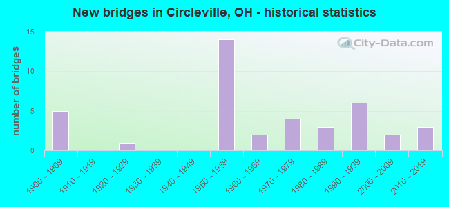
- New bridges - historical statistics
- 51900-1909
- 11920-1929
- 141950-1959
- 21960-1969
- 41970-1979
- 31980-1989
- 61990-1999
- 22000-2009
- 32010-2019

- Reconstructed bridges - Historical Statistics
- 41970-1979
- 21980-1989
- 31990-1999
- 22000-2009
- 32010-2019


- Bridge Condition - Deck
- 13.9%Excellent
- 41.7%Very good
- 25.0%Good
- 13.9%Satisfactory
- 5.6%Fair

- Bridge Condition - Superstructure
- 30.6%Excellent
- 30.6%Very good
- 25.0%Good
- 8.3%Satisfactory
- 5.6%Fair

- Bridge Condition - Substructure
- 11.1%Excellent
- 36.1%Very good
- 27.8%Good
- 22.2%Satisfactory
- 2.8%Fair

- Bridge Condition - Channel
- 18.8%Excellent
- 31.3%Very good
- 21.9%Good
- 18.8%Satisfactory
- 3.1%Fair
- 6.3%Poor

- Bridge Condition - Culverts
- 50.0%Excellent
- 50.0%Good
Find on map >> Show street view
Structure Number: 6500285, Location: 0.03 MI N. OF SR56 (Lat: 39.599989, Lng: -82.971739), Route carried "on" structure: US 22, Year Built: 1970, Status: Open, Structure Length: 17.44m (57.22ft), Average Daily Traffic: 8,092 (year 2015), Truck Traffic: 12%, Average Future Daily Traffic: 11,232 (year 2035), Design Load: HS 20, Features Intersected: SCIOTO RIVER OVERFLOW
Minimum Vertical Clearance: 30+ m (98+ ft), Kilometerpoint: 25.878, Lanes on structure: 2, Base Highway Network: Yes, Owner: State Highway Agency, Approaching Roadway Width: 10.7m (35.1ft), Material/Design: Prestressed concrete, Design/Construction: Box Beam or Girders - Multiple, Number Of Spans In Main Unit: 18, Length of Maximum Span: 9.9m (32.5ft), Curb-To-Curb Width: 9.8m (32.2ft), Out-to-Out Width: 9.8m (32.2ft)
Condition: Deck: Good, Superstructure: Good, Substructure: Satisfactory, Channel: Very good, Operating Rating: 42.1 metric tons, Method Used To Determine Operating Rating: Load Factor (LF) rating reported by rating factor (RF) method using MS18 loading, Inventory Rating: 32.4 metric tons, Method Used To Determine Inventory Rating: Load Factor (LF) rating reported by rating factor (RF) method using MS18 loading, Structural Evaluation: Equal to present minimum criteria, Deck Geometry: Meets minimum limits, Waterway Adequacy: Equal to present desirable criteria, Approach Roadway Alignment: Better than present minimum criteria, Designated Inspection Frequency: Every 12 months, Inspection Date: Febuary 2022, Deck Structure Type: Concrete Cast-file-Place, Wearing Surface/Protective System: Wearing Surface: Bituminous, Membrane: Built-up
Find on map >> Show street view
Structure Number: 6500307, Location: 0.03 MI N OF TWP RD 502 (Lat: 39.600969, Lng: -82.968739), Route carried "on" structure: US 22, Year Built: 1970, Status: Open, Structure Length: 24.38m (79.99ft), Average Daily Traffic: 8,092 (year 2018), Truck Traffic: 12%, Average Future Daily Traffic: 11,232 (year 2038), Design Load: HS 20, Features Intersected: SCIOTO RIVER OVERFLOW
Minimum Vertical Clearance: 30+ m (98+ ft), Kilometerpoint: 26.216, Lanes on structure: 2, Base Highway Network: Yes, Owner: State Highway Agency, Approaching Roadway Width: 10.7m (35.1ft), Material/Design: Prestressed concrete, Design/Construction: Box Beam or Girders - Multiple, Number Of Spans In Main Unit: 27, Length of Maximum Span: 9.1m (29.9ft), Curb-To-Curb Width: 9.8m (32.2ft), Out-to-Out Width: 9.8m (32.2ft)
Condition: Deck: Good, Superstructure: Satisfactory, Substructure: Satisfactory, Channel: Fair, Operating Rating: 42.1 metric tons, Method Used To Determine Operating Rating: Load Factor (LF) rating reported by rating factor (RF) method using MS18 loading, Inventory Rating: 32.4 metric tons, Method Used To Determine Inventory Rating: Load Factor (LF) rating reported by rating factor (RF) method using MS18 loading, Structural Evaluation: Equal to present minimum criteria, Deck Geometry: Meets minimum limits, Waterway Adequacy: Equal to present desirable criteria, Approach Roadway Alignment: Better than present minimum criteria, Designated Inspection Frequency: Every 12 months, Inspection Date: Febuary 2022, Deck Structure Type: Concrete Cast-file-Place, Wearing Surface/Protective System: Wearing Surface: Bituminous, Membrane: Built-up
Find on map >> Show street view
Structure Number: 6500358, Location: OVER SCIOTO R W OF C'VILL (Lat: 39.601089, Lng: -82.956161), Route carried "on" structure: US 22, Year Built: 2003, Status: Open, Structure Length: 19.33m (63.42ft), Average Daily Traffic: 8,092 (year 2015), Truck Traffic: 12%, Average Future Daily Traffic: 11,232 (year 2035), Design Load: HS 25 or greater, Features Intersected: OVER SCIOTO RIVER
Minimum Vertical Clearance: 30+ m (98+ ft), Kilometerpoint: 27.343, Lanes on structure: 2, Base Highway Network: Yes, Owner: State Highway Agency, Approaching Roadway Width: 9.8m (32.2ft), Material/Design: Steel continuous, Design/Construction: Stringer/Multi-beam, Number Of Spans In Main Unit: 6, Length of Maximum Span: 34.4m (112.9ft), Curb or Sidewalk Widths: Left: 0.0m, Right: 2.4m (7.9ft), Curb-To-Curb Width: 9.8m (32.2ft), Out-to-Out Width: 13.4m (44.0ft)
Condition: Deck: Very good, Superstructure: Very good, Substructure: Very good, Channel: Very good, Operating Rating: 42.1 metric tons, Method Used To Determine Operating Rating: Load Factor (LF) rating reported by rating factor (RF) method using MS18 loading, Inventory Rating: 32.4 metric tons, Method Used To Determine Inventory Rating: Load Factor (LF) rating reported by rating factor (RF) method using MS18 loading, Structural Evaluation: Equal to present desirable criteria, Deck Geometry: Meets minimum limits, Waterway Adequacy: Superior to present desirable criteria, Approach Roadway Alignment: Somewhat better than minimum adequacy, Designated Inspection Frequency: Every 24 months, Inspection Date: Febuary 2021, Deck Structure Type: Concrete Cast-file-Place, Wearing Surface/Protective System: Wearing Surface: Monolithic Concrete, Deck Protection: Epoxy Coated Reinforcing
Find on map >> Show street view
Structure Number: 650039, Location: 1.17 MI N OF US23 (Lat: 39.599031, Lng: -82.931889), Route carried "on" structure: US 22, Year Built: 1966, Status: Open, Structure Length: 2.82m (9.25ft), Average Daily Traffic: 11,828 (year 2015), Truck Traffic: 7%, Average Future Daily Traffic: 16,417 (year 2035), Design Load: HS 20+Mod, Features Intersected: OVER HARGUS CREEK
Minimum Vertical Clearance: 30+ m (98+ ft), Kilometerpoint: 29.564, Lanes on structure: 2, Base Highway Network: Yes, Owner: State Highway Agency, Approaching Roadway Width: 9.4m (30.8ft), Skew: 1 degrees, Material/Design: Concrete continuous, Design/Construction: Slab, Number Of Spans In Main Unit: 3, Length of Maximum Span: 10.7m (35.1ft), Curb or Sidewalk Widths: Left: 1.8m (5.9ft), Right: 1.8m (5.9ft), Curb-To-Curb Width: 11.1m (36.4ft), Out-to-Out Width: 14.8m (48.6ft)
Condition: Deck: Good, Superstructure: Good, Substructure: Satisfactory, Channel: Excellent, Operating Rating: 42.1 metric tons, Method Used To Determine Operating Rating: Load Factor (LF) rating reported by rating factor (RF) method using MS18 loading, Inventory Rating: 32.4 metric tons, Method Used To Determine Inventory Rating: Load Factor (LF) rating reported by rating factor (RF) method using MS18 loading, Structural Evaluation: Equal to present minimum criteria, Deck Geometry: Meets minimum limits, Waterway Adequacy: Equal to present desirable criteria, Approach Roadway Alignment: Equal to present desirable criteria, Designated Inspection Frequency: Every 12 months, Inspection Date: Febuary 2022, Deck Structure Type: Concrete Cast-file-Place, Wearing Surface/Protective System: Wearing Surface: Integral Concrete
Find on map >> Show street view
Structure Number: 6500412, Location: 2.04 MI E OF US 23 (Lat: 39.604919, Lng: -82.917150), Route carried "on" structure: US 22, Year Built: 1993, Status: Open, Structure Length: 2.13m (6.99ft), Average Daily Traffic: 7,417 (year 2015), Truck Traffic: 8%, Average Future Daily Traffic: 10,295 (year 2035), Design Load: HS 20+Mod, Features Intersected: HARGUS CREEK
Minimum Vertical Clearance: 30+ m (98+ ft), Kilometerpoint: 30.980, Lanes on structure: 2, Base Highway Network: Yes, Owner: State Highway Agency, Approaching Roadway Width: 13.4m (44.0ft), Skew: 3 degrees, Material/Design: Prestressed concrete, Design/Construction: Box Beam or Girders - Multiple, Number Of Spans In Main Unit: 1, Length of Maximum Span: 20.1m (65.9ft), Curb-To-Curb Width: 13.4m (44.0ft), Out-to-Out Width: 13.4m (44.0ft)
Condition: Deck: Very good, Superstructure: Very good, Substructure: Very good, Channel: Very good, Operating Rating: 42.1 metric tons, Method Used To Determine Operating Rating: Load Factor (LF) rating reported by rating factor (RF) method using MS18 loading, Inventory Rating: 32.4 metric tons, Method Used To Determine Inventory Rating: Load Factor (LF) rating reported by rating factor (RF) method using MS18 loading, Structural Evaluation: Equal to present desirable criteria, Deck Geometry: Equal to present minimum criteria, Waterway Adequacy: Equal to present desirable criteria, Approach Roadway Alignment: Superior to present desirable criteria, Designated Inspection Frequency: Every 24 months, Inspection Date: March 2021, Deck Structure Type: Concrete Cast-file-Place, Wearing Surface/Protective System: Wearing Surface: Bituminous, Membrane: Built-up
Find on map >> Show street view
Structure Number: 6500668, Location: 0.78 MI S OF US22 (Lat: 39.591850, Lng: -82.954569), Route carried "on" structure: US 23, Year Built: 1957, Year Reconstructed: 2004, Status: Open, Structure Length: 4.50m (14.76ft), Average Daily Traffic: 14,187 (year 2018), Truck Traffic: 14%, Average Future Daily Traffic: 19,692 (year 2038), Design Load: HS 25 or greater, Features Intersected: OVER NS RR
Minimum Vertical Clearance: 30+ m (98+ ft), Kilometerpoint: 12.843, Lanes on structure: 2, Base Highway Network: Yes, Owner: State Highway Agency, Approaching Roadway Width: 10.2m (33.5ft), Skew: 1 degrees, Material/Design: Steel continuous, Design/Construction: Stringer/Multi-beam, Number Of Spans In Main Unit: 3, Length of Maximum Span: 16.8m (55.1ft), Curb-To-Curb Width: 10.2m (33.5ft), Out-to-Out Width: 11.1m (36.4ft)
Condition: Deck: Very good, Superstructure: Excellent, Substructure: Very good, Operating Rating: 42.1 metric tons, Method Used To Determine Operating Rating: Allowable Stress (AS) rating reported by rating factor (RF) method using MS18 loading, Inventory Rating: 32.4 metric tons, Method Used To Determine Inventory Rating: Allowable Stress (AS) rating reported by rating factor (RF) method using MS18 loading, Structural Evaluation: Equal to present desirable criteria, Deck Geometry: Somewhat better than minimum adequacy, Underclear: High priority of corrective action, Approach Roadway Alignment: Equal to present desirable criteria, Designated Inspection Frequency: Every 24 months, Inspection Date: March 2021, Deck Structure Type: Concrete Cast-file-Place, Wearing Surface/Protective System: Wearing Surface: Monolithic Concrete, Deck Protection: Epoxy Coated Reinforcing
Find on map >> Show street view
Structure Number: 6500692, Location: 0.78 MI S OF US22 (Lat: 39.591931, Lng: -82.954361), Route carried "on" structure: US 23, Year Built: 1957, Year Reconstructed: 2004, Status: Open, Structure Length: 4.50m (14.76ft), Average Daily Traffic: 14,187 (year 2018), Truck Traffic: 14%, Average Future Daily Traffic: 19,692 (year 2038), Design Load: HS 25 or greater, Features Intersected: OVER NS RR
Minimum Vertical Clearance: 30+ m (98+ ft), Kilometerpoint: 12.843, Lanes on structure: 2, Base Highway Network: Yes, Owner: State Highway Agency, Approaching Roadway Width: 10.2m (33.5ft), Skew: 1 degrees, Material/Design: Steel continuous, Design/Construction: Stringer/Multi-beam, Number Of Spans In Main Unit: 3, Length of Maximum Span: 16.8m (55.1ft), Curb-To-Curb Width: 10.2m (33.5ft), Out-to-Out Width: 11.1m (36.4ft)
Condition: Deck: Very good, Superstructure: Excellent, Substructure: Very good, Operating Rating: 42.1 metric tons, Method Used To Determine Operating Rating: Allowable Stress (AS) rating reported by rating factor (RF) method using MS18 loading, Inventory Rating: 32.4 metric tons, Method Used To Determine Inventory Rating: Allowable Stress (AS) rating reported by rating factor (RF) method using MS18 loading, Structural Evaluation: Equal to present desirable criteria, Deck Geometry: Somewhat better than minimum adequacy, Underclear: High priority of corrective action, Approach Roadway Alignment: Equal to present desirable criteria, Designated Inspection Frequency: Every 24 months, Inspection Date: March 2021, Deck Structure Type: Concrete Cast-file-Place, Wearing Surface/Protective System: Wearing Surface: Monolithic Concrete, Deck Protection: Epoxy Coated Reinforcing
Find on map >> Show street view
Structure Number: 6500722, Location: OVER US22-1726 (Lat: 39.602619, Lng: -82.951839), Route carried "on" structure: US 23, Year Built: 1957, Year Reconstructed: 2010, Status: Open, Structure Length: 6.78m (22.24ft), Average Daily Traffic: 25,405 (year 2018), Truck Traffic: 15%, Average Future Daily Traffic: 35,262 (year 2038), Design Load: HS 25 or greater, Features Intersected: OVER US22-1726
Minimum Vertical Clearance: 4.62m (15.16ft), Kilometerpoint: 14.098, Lanes on structure: 5, Lanes under structure: 4, Base Highway Network: Yes, Owner: State Highway Agency, Approaching Roadway Width: 29.3m (96.1ft), Skew: 14 degrees, Material/Design: Steel continuous, Design/Construction: Stringer/Multi-beam, Number Of Spans In Main Unit: 4, Length of Maximum Span: 18.3m (60.0ft), Curb-To-Curb Width: 29.3m (96.1ft), Out-to-Out Width: 30.2m (99.1ft)
Condition: Deck: Very good, Superstructure: Excellent, Substructure: Very good, Operating Rating: 77.8 metric tons, Method Used To Determine Operating Rating: Allowable Stress (AS) rating reported by rating factor (RF) method using MS18 loading, Inventory Rating: 74.5 metric tons, Method Used To Determine Inventory Rating: Allowable Stress (AS) rating reported by rating factor (RF) method using MS18 loading, Structural Evaluation: Equal to present desirable criteria, Deck Geometry: Equal to present minimum criteria, Underclear: Meets minimum limits, Approach Roadway Alignment: Equal to present desirable criteria, Designated Inspection Frequency: Every 24 months, Inspection Date: March 2021, Deck Structure Type: Concrete Cast-file-Place, Wearing Surface/Protective System: Wearing Surface: Monolithic Concrete, Deck Protection: Epoxy Coated Reinforcing
Find on map >> Show street view
Structure Number: 6500757, Location: 0.22 MI N OF US22 (Lat: 39.605919, Lng: -82.950769), Route carried "on" structure: US 23, Year Built: 1957, Year Reconstructed: 2010, Status: Open, Structure Length: 3.61m (11.84ft), Average Daily Traffic: 11,218 (year 2018), Truck Traffic: 16%, Average Future Daily Traffic: 15,571 (year 2038), Design Load: H 20, Features Intersected: HARGUS CREEK
Minimum Vertical Clearance: 30+ m (98+ ft), Kilometerpoint: 14.452, Lanes on structure: 3, Base Highway Network: Yes, Owner: State Highway Agency, Approaching Roadway Width: 15.9m (52.2ft), Material/Design: Concrete continuous, Design/Construction: Slab, Number Of Spans In Main Unit: 3, Length of Maximum Span: 13.7m (44.9ft), Curb-To-Curb Width: 15.9m (52.2ft), Out-to-Out Width: 16.8m (55.1ft)
Condition: Deck: Excellent, Superstructure: Excellent, Substructure: Very good, Channel: Excellent, Operating Rating: 42.1 metric tons, Method Used To Determine Operating Rating: Load Factor (LF) rating reported by rating factor (RF) method using MS18 loading, Inventory Rating: 32.4 metric tons, Method Used To Determine Inventory Rating: Load Factor (LF) rating reported by rating factor (RF) method using MS18 loading, Structural Evaluation: Equal to present desirable criteria, Deck Geometry: Better than present minimum criteria, Waterway Adequacy: Equal to present minimum criteria, Approach Roadway Alignment: Equal to present desirable criteria, Designated Inspection Frequency: Every 24 months, Inspection Date: March 2021, Deck Structure Type: Concrete Cast-file-Place, Wearing Surface/Protective System: Wearing Surface: Monolithic Concrete, Deck Protection: Epoxy Coated Reinforcing
Find on map >> Show street view
Structure Number: 6500781, Location: 0.22 MI N. OF US22 (Lat: 39.605889, Lng: -82.950481), Route carried "on" structure: US 23, Year Built: 1957, Year Reconstructed: 2010, Status: Open, Structure Length: 3.61m (11.84ft), Average Daily Traffic: 11,218 (year 2018), Truck Traffic: 16%, Average Future Daily Traffic: 15,571 (year 2038), Design Load: H 20, Features Intersected: HARGUS CREEK
Minimum Vertical Clearance: 30+ m (98+ ft), Kilometerpoint: 14.452, Lanes on structure: 3, Base Highway Network: Yes, Owner: State Highway Agency, Approaching Roadway Width: 15.9m (52.2ft), Material/Design: Concrete continuous, Design/Construction: Slab, Number Of Spans In Main Unit: 3, Length of Maximum Span: 13.7m (44.9ft), Curb-To-Curb Width: 15.9m (52.2ft), Out-to-Out Width: 16.8m (55.1ft)
Condition: Deck: Very good, Superstructure: Very good, Substructure: Very good, Channel: Excellent, Operating Rating: 42.1 metric tons, Method Used To Determine Operating Rating: Load Factor (LF) rating reported by rating factor (RF) method using MS18 loading, Inventory Rating: 32.4 metric tons, Method Used To Determine Inventory Rating: Load Factor (LF) rating reported by rating factor (RF) method using MS18 loading, Structural Evaluation: Equal to present desirable criteria, Deck Geometry: Better than present minimum criteria, Waterway Adequacy: Equal to present minimum criteria, Approach Roadway Alignment: Equal to present desirable criteria, Designated Inspection Frequency: Every 24 months, Inspection Date: March 2021, Deck Structure Type: Concrete Cast-file-Place, Wearing Surface/Protective System: Wearing Surface: Monolithic Concrete, Deck Protection: Epoxy Coated Reinforcing
Find on map >> Show street view
Structure Number: 6500811, Location: 0.52 MI N OF US22 (Lat: 39.610150, Lng: -82.949250), Route carried "on" structure: County highway ISLND, Year Built: 1957, Year Reconstructed: 2001, Status: Open, Structure Length: 6.17m (20.24ft), Average Daily Traffic: 719 (year 2018), Truck Traffic: 5%, Average Future Daily Traffic: 31,141 (year 2038), Design Load: H 15, Features Intersected: US 23, Facility Carried by Structure: ISLAND ROAD
Minimum Vertical Clearance: 30+ m (98+ ft), Kilometerpoint: 0.000, Lanes on structure: 2, Lanes under structure: 4, Owner: State Highway Agency, Approaching Roadway Width: 9.8m (32.2ft), Material/Design: Steel continuous, Design/Construction: Stringer/Multi-beam, Number Of Spans In Main Unit: 4, Length of Maximum Span: 16.8m (55.1ft), Curb-To-Curb Width: 9.8m (32.2ft), Out-to-Out Width: 10.7m (35.1ft)
Condition: Deck: Good, Superstructure: Very good, Substructure: Very good, Operating Rating: 42.1 metric tons, Method Used To Determine Operating Rating: Load Factor (LF) rating reported by rating factor (RF) method using MS18 loading, Inventory Rating: 32.4 metric tons, Method Used To Determine Inventory Rating: Load Factor (LF) rating reported by rating factor (RF) method using MS18 loading, Structural Evaluation: Equal to present desirable criteria, Deck Geometry: Equal to present minimum criteria, Underclear: High priority of corrective action, Approach Roadway Alignment: Better than present minimum criteria, Designated Inspection Frequency: Every 24 months, Inspection Date: March 2021, Deck Structure Type: Concrete Cast-file-Place, Wearing Surface/Protective System: Wearing Surface: Monolithic Concrete
Find on map >> Show street view
Structure Number: 6500846, Location: 1.17 MI N OF US22 (Lat: 39.619461, Lng: -82.950711), Route carried "on" structure: US 23, Year Built: 1957, Status: Open, Structure Length: 0.82m (2.69ft), Average Daily Traffic: 22,436 (year 2018), Truck Traffic: 16%, Average Future Daily Traffic: 31,141 (year 2038), Design Load: H 20, Features Intersected: ISLAND RUN
Minimum Vertical Clearance: 30+ m (98+ ft), Kilometerpoint: 15.981, Lanes on structure: 4, Base Highway Network: Yes, Owner: State Highway Agency, Approaching Roadway Width: 32.9m (107.9ft), Skew: 3 degrees, Material/Design: Concrete, Design/Construction: Culvert, Number Of Spans In Main Unit: 3, Length of Maximum Span: 1.5m (4.9ft)
Condition: Channel: Satisfactory, Culverts: Good, Operating Rating: 32.4 metric tons, Method Used To Determine Operating Rating: Load Factor (LF) rating reported by rating factor (RF) method using MS18 loading, Inventory Rating: 25.9 metric tons, Method Used To Determine Inventory Rating: Load Factor (LF) rating reported by rating factor (RF) method using MS18 loading, Structural Evaluation: Equal to present minimum criteria, Waterway Adequacy: Equal to present desirable criteria, Approach Roadway Alignment: Equal to present desirable criteria, Designated Inspection Frequency: Every 24 months, Inspection Date: March 2021
Find on map >> Show street view
Structure Number: 650087, Location: 1.62 MI N OF US22 (Lat: 39.625089, Lng: -82.953161), Route carried "on" structure: US 23, Year Built: 1957, Status: Open, Structure Length: 19.45m (63.81ft), Average Daily Traffic: 11,218 (year 2015), Truck Traffic: 16%, Average Future Daily Traffic: 15,571 (year 2035), Design Load: H 20, Features Intersected: OVER CSX RR (OLD C&O)
Minimum Vertical Clearance: 30+ m (98+ ft), Kilometerpoint: 16.705, Lanes on structure: 2, Base Highway Network: Yes, Owner: State Highway Agency, Approaching Roadway Width: 13.4m (44.0ft), Material/Design: Steel continuous, Design/Construction: Stringer/Multi-beam, Number Of Spans In Main Unit: 7, Number Of Approach Spans: 10, Length of Maximum Span: 18.6m (61.0ft), Curb-To-Curb Width: 10.8m (35.4ft), Out-to-Out Width: 11.2m (36.7ft)
Condition: Deck: Good, Superstructure: Good, Substructure: Satisfactory, Operating Rating: 35.6 metric tons, Method Used To Determine Operating Rating: Allowable Stress (AS) rating reported by rating factor (RF) method using MS18 loading, Inventory Rating: 32.4 metric tons, Method Used To Determine Inventory Rating: Allowable Stress (AS) rating reported by rating factor (RF) method using MS18 loading, Structural Evaluation: Equal to present minimum criteria, Deck Geometry: Somewhat better than minimum adequacy, Underclear: Somewhat better than minimum adequacy, Approach Roadway Alignment: Better than present minimum criteria, Designated Inspection Frequency: Every 12 months, Critical Feature Inspection Frequency: Every 24 months, Inspection Date: March 2021, Critical Feature Inspection Date: April 2021, Deck Structure Type: Concrete Cast-file-Place, Wearing Surface/Protective System: Wearing Surface: Integral Concrete
Find on map >> Show street view
Structure Number: 65009, Location: 1.62 MI N OF US22 (Lat: 39.625669, Lng: -82.953181), Route carried "on" structure: US 23, Year Built: 1957, Status: Open, Structure Length: 19.45m (63.81ft), Average Daily Traffic: 11,218 (year 2015), Truck Traffic: 16%, Average Future Daily Traffic: 15,571 (year 2035), Design Load: H 20, Features Intersected: OVER CSX RR (OLD C&O)
Minimum Vertical Clearance: 30+ m (98+ ft), Kilometerpoint: 16.705, Lanes on structure: 2, Base Highway Network: Yes, Owner: State Highway Agency, Approaching Roadway Width: 13.4m (44.0ft), Material/Design: Steel continuous, Design/Construction: Stringer/Multi-beam, Number Of Spans In Main Unit: 7, Number Of Approach Spans: 10, Length of Maximum Span: 18.6m (61.0ft), Curb-To-Curb Width: 10.8m (35.4ft), Out-to-Out Width: 11.2m (36.7ft)
Condition: Deck: Good, Superstructure: Good, Substructure: Satisfactory, Operating Rating: 42.1 metric tons, Method Used To Determine Operating Rating: Load Factor (LF) rating reported by rating factor (RF) method using MS18 loading, Inventory Rating: 29.2 metric tons, Method Used To Determine Inventory Rating: Load Factor (LF) rating reported by rating factor (RF) method using MS18 loading, Structural Evaluation: Equal to present minimum criteria, Deck Geometry: Somewhat better than minimum adequacy, Underclear: Somewhat better than minimum adequacy, Approach Roadway Alignment: Better than present minimum criteria, Designated Inspection Frequency: Every 12 months, Critical Feature Inspection Frequency: Every 24 months, Inspection Date: March 2021, Critical Feature Inspection Date: April 2021, Deck Structure Type: Concrete Cast-file-Place, Wearing Surface/Protective System: Wearing Surface: Integral Concrete
Find on map >> Show street view
Structure Number: 6500935, Location: 2.94 MI N OF US22 (Lat: 39.644469, Lng: -82.957181), Route carried "on" structure: US 23, Year Built: 1957, Year Reconstructed: 2009, Status: Open, Structure Length: 2.24m (7.35ft), Average Daily Traffic: 11,218 (year 2018), Truck Traffic: 16%, Average Future Daily Traffic: 15,571 (year 2038), Design Load: H 20, Features Intersected: GRIFFYS RN
Minimum Vertical Clearance: 30+ m (98+ ft), Kilometerpoint: 18.829, Lanes on structure: 2, Base Highway Network: Yes, Owner: State Highway Agency, Approaching Roadway Width: 12.8m (42.0ft), Material/Design: Concrete continuous, Design/Construction: Slab, Number Of Spans In Main Unit: 2, Length of Maximum Span: 11.0m (36.1ft), Curb-To-Curb Width: 12.8m (42.0ft), Out-to-Out Width: 13.7m (44.9ft)
Condition: Deck: Very good, Superstructure: Excellent, Substructure: Very good, Channel: Poor, Operating Rating: 42.1 metric tons, Method Used To Determine Operating Rating: Load Factor (LF) rating reported by rating factor (RF) method using MS18 loading, Inventory Rating: 32.4 metric tons, Method Used To Determine Inventory Rating: Load Factor (LF) rating reported by rating factor (RF) method using MS18 loading, Structural Evaluation: Equal to present desirable criteria, Deck Geometry: Equal to present desirable criteria, Waterway Adequacy: Equal to present desirable criteria, Approach Roadway Alignment: Equal to present desirable criteria, Designated Inspection Frequency: Every 24 months, Inspection Date: March 2021, Deck Structure Type: Concrete Cast-file-Place, Wearing Surface/Protective System: Wearing Surface: Monolithic Concrete
Find on map >> Show street view
Structure Number: 6500994, Location: 2.94 MI. N. OF US22 (Lat: 39.644489, Lng: -82.956950), Route carried "on" structure: US 23, Year Built: 1957, Year Reconstructed: 2009, Status: Open, Structure Length: 2.24m (7.35ft), Average Daily Traffic: 11,218 (year 2018), Truck Traffic: 16%, Average Future Daily Traffic: 15,571 (year 2038), Design Load: H 20, Features Intersected: GRIFFYS RN
Minimum Vertical Clearance: 30+ m (98+ ft), Kilometerpoint: 18.829, Lanes on structure: 2, Base Highway Network: Yes, Owner: State Highway Agency, Approaching Roadway Width: 12.8m (42.0ft), Material/Design: Concrete continuous, Design/Construction: Slab, Number Of Spans In Main Unit: 2, Length of Maximum Span: 11.0m (36.1ft), Curb-To-Curb Width: 12.8m (42.0ft), Out-to-Out Width: 13.7m (44.9ft)
Condition: Deck: Very good, Superstructure: Excellent, Substructure: Good, Channel: Poor, Operating Rating: 42.1 metric tons, Method Used To Determine Operating Rating: Load Factor (LF) rating reported by rating factor (RF) method using MS18 loading, Inventory Rating: 32.4 metric tons, Method Used To Determine Inventory Rating: Load Factor (LF) rating reported by rating factor (RF) method using MS18 loading, Structural Evaluation: Better than present minimum criteria, Deck Geometry: Equal to present desirable criteria, Waterway Adequacy: Equal to present desirable criteria, Approach Roadway Alignment: Equal to present desirable criteria, Designated Inspection Frequency: Every 24 months, Inspection Date: March 2021, Deck Structure Type: Concrete Cast-file-Place, Wearing Surface/Protective System: Wearing Surface: Monolithic Concrete
Find on map >> Show street view
Structure Number: 6502016, Location: 1.16 MI N OF SR56 (Lat: 39.628281, Lng: -83.009689), Route carried "on" structure: State highway 104, Year Built: 1950, Year Reconstructed: 1983, Status: Open, Structure Length: 8.92m (29.27ft), Average Daily Traffic: 2,653 (year 2015), Truck Traffic: 9%, Average Future Daily Traffic: 3,682 (year 2035), Design Load: HS 20+Mod, Features Intersected: BIG DARBY CREEK
Minimum Vertical Clearance: 30+ m (98+ ft), Kilometerpoint: 14.259, Lanes on structure: 2, Owner: State Highway Agency, Approaching Roadway Width: 7.3m (24.0ft), Material/Design: Steel continuous, Design/Construction: Stringer/Multi-beam, Number Of Spans In Main Unit: 4, Length of Maximum Span: 24.4m (80.1ft), Curb-To-Curb Width: 8.5m (27.9ft), Out-to-Out Width: 8.5m (27.9ft)
Condition: Deck: Good, Superstructure: Good, Substructure: Good, Channel: Good, Operating Rating: 35.6 metric tons, Method Used To Determine Operating Rating: Allowable Stress (AS) rating reported by rating factor (RF) method using MS18 loading, Inventory Rating: 32.4 metric tons, Method Used To Determine Inventory Rating: Allowable Stress (AS) rating reported by rating factor (RF) method using MS18 loading, Structural Evaluation: Better than present minimum criteria, Deck Geometry: Meets minimum limits, Waterway Adequacy: Equal to present desirable criteria, Approach Roadway Alignment: Equal to present desirable criteria, Designated Inspection Frequency: Every 24 months, Inspection Date: December 2020, Deck Structure Type: Concrete Cast-file-Place, Wearing Surface/Protective System: Wearing Surface: Monolithic Concrete, Deck Protection: Epoxy Coated Reinforcing
Find on map >> Show street view
Structure Number: 650204, Location: 1.24 MI N. OF SR56 (Lat: 39.629419, Lng: -83.009919), Route carried "on" structure: State highway 104, Year Built: 1960, Status: Open, Structure Length: 6.10m (20.01ft), Average Daily Traffic: 2,653 (year 2015), Truck Traffic: 9%, Average Future Daily Traffic: 3,682 (year 2035), Design Load: H 15, Features Intersected: BIG DARBY CREEK FLOODWAY
Minimum Vertical Clearance: 30+ m (98+ ft), Kilometerpoint: 14.388, Lanes on structure: 2, Owner: State Highway Agency, Approaching Roadway Width: 9.8m (32.2ft), Skew: 3 degrees, Material/Design: Concrete continuous, Design/Construction: Slab, Number Of Spans In Main Unit: 5, Length of Maximum Span: 12.2m (40.0ft), Curb-To-Curb Width: 9.8m (32.2ft), Out-to-Out Width: 9.8m (32.2ft)
Condition: Deck: Good, Superstructure: Very good, Substructure: Very good, Channel: Very good, Operating Rating: 49.6 metric tons, Method Used To Determine Operating Rating: Load Factor (LF) rating reported by rating factor (RF) method using MS18 loading, Inventory Rating: 29.5 metric tons, Method Used To Determine Inventory Rating: Load Factor (LF) rating reported by rating factor (RF) method using MS18 loading, Structural Evaluation: Better than present minimum criteria, Deck Geometry: Meets minimum limits, Waterway Adequacy: Equal to present desirable criteria, Approach Roadway Alignment: Equal to present desirable criteria, Designated Inspection Frequency: Every 24 months, Inspection Date: June 2020, Deck Structure Type: Concrete Cast-file-Place, Wearing Surface/Protective System: Wearing Surface: Integral Concrete
Find on map >> Show street view
Structure Number: 6502822, Location: 0.25 MI N OF US 22 (Lat: 39.605069, Lng: -82.943450), Route carried "on" structure: State highway 188, Year Built: 1924, Status: Open, Structure Length: 1.77m (5.81ft), Average Daily Traffic: 11,718 (year 2015), Truck Traffic: 3%, Average Future Daily Traffic: 16,265 (year 2035), Design Load: H 15, Features Intersected: HARGUS CREEK
Minimum Vertical Clearance: 30+ m (98+ ft), Kilometerpoint: 0.402, Lanes on structure: 4, Owner: State Highway Agency, Approaching Roadway Width: 17.1m (56.1ft), Material/Design: Concrete, Design/Construction: Arch - Deck, Number Of Spans In Main Unit: 1, Length of Maximum Span: 17.1m (56.1ft), Curb or Sidewalk Widths: Left: 2.3m (7.5ft), Right: 2.3m (7.5ft), Curb-To-Curb Width: 16.9m (55.4ft), Out-to-Out Width: 25.4m (83.3ft)
Condition: Deck: Satisfactory, Superstructure: Fair, Substructure: Satisfactory, Channel: Good, Operating Rating: 42.1 metric tons, Method Used To Determine Operating Rating: Load Factor (LF) rating reported by rating factor (RF) method using MS18 loading, Inventory Rating: 32.4 metric tons, Method Used To Determine Inventory Rating: Load Factor (LF) rating reported by rating factor (RF) method using MS18 loading, Structural Evaluation: Somewhat better than minimum adequacy, Deck Geometry: Somewhat better than minimum adequacy, Waterway Adequacy: Equal to present desirable criteria, Approach Roadway Alignment: Equal to present desirable criteria, Designated Inspection Frequency: Every 12 months, Inspection Date: August 2021, Wearing Surface/Protective System: Wearing Surface: Bituminous
Find on map >> Show street view
Structure Number: 6502849, Location: 3.11 MI N OF US22(MAIN ST (Lat: 39.633269, Lng: -82.906200), Route carried "on" structure: State highway 188, Year Built: 1992, Status: Open, Structure Length: 1.26m (4.13ft), Average Daily Traffic: 1,900 (year 2015), Truck Traffic: 7%, Average Future Daily Traffic: 2,637 (year 2035), Design Load: HS 20, Features Intersected: GRIFFY RUN
Minimum Vertical Clearance: 30+ m (98+ ft), Kilometerpoint: 5.021, Lanes on structure: 2, Owner: State Highway Agency, Approaching Roadway Width: 11.0m (36.1ft), Material/Design: Prestressed concrete, Design/Construction: Box Beam or Girders - Multiple, Number Of Spans In Main Unit: 1, Length of Maximum Span: 12.2m (40.0ft), Curb-To-Curb Width: 11.0m (36.1ft), Out-to-Out Width: 11.0m (36.1ft)
Condition: Deck: Excellent, Superstructure: Excellent, Substructure: Excellent, Channel: Very good, Operating Rating: 42.1 metric tons, Method Used To Determine Operating Rating: Load Factor (LF) rating reported by rating factor (RF) method using MS18 loading, Inventory Rating: 32.4 metric tons, Method Used To Determine Inventory Rating: Load Factor (LF) rating reported by rating factor (RF) method using MS18 loading, Structural Evaluation: Equal to present desirable criteria, Deck Geometry: Equal to present minimum criteria, Waterway Adequacy: Equal to present desirable criteria, Approach Roadway Alignment: Equal to present desirable criteria, Designated Inspection Frequency: Every 24 months, Inspection Date: June 2020, Deck Structure Type: Concrete Cast-file-Place, Wearing Surface/Protective System: Wearing Surface: Bituminous, Membrane: Built-up
Find on map >> Show street view
Structure Number: 6530006, Location: 0.5MI W. OF WALNUT CREEK (Lat: 39.653611, Lng: -82.933889), Route carried "on" structure: County highway T0039, Year Built: 2014, Status: Open, Structure Length: 0.98m (3.22ft), Average Daily Traffic: 1,187 (year 2015), Truck Traffic: 7%, Average Future Daily Traffic: 1,648 (year 2035), Design Load: HS 20, Features Intersected: DRY RUN CREEK, Facility Carried by Structure: BELL STATION ROAD
Minimum Vertical Clearance: 30+ m (98+ ft), Kilometerpoint: 1.947, Lanes on structure: 2, Owner: County Highway Agency, Approaching Roadway Width: 6.7m (22.0ft), Material/Design: Concrete, Design/Construction: Culvert, Number Of Spans In Main Unit: 1, Length of Maximum Span: 8.8m (28.9ft)
Condition: Channel: Excellent, Culverts: Excellent, Operating Rating: 45.4 metric tons, Method Used To Determine Operating Rating: Load Factor (LF) rating reported by rating factor (RF) method using MS18 loading, Inventory Rating: 25.9 metric tons, Method Used To Determine Inventory Rating: Load Factor (LF) rating reported by rating factor (RF) method using MS18 loading, Structural Evaluation: Equal to present minimum criteria, Waterway Adequacy: Superior to present desirable criteria, Approach Roadway Alignment: Better than present minimum criteria, Designated Inspection Frequency: Every 24 months, Inspection Date: December 2020, Deck Structure Type: Concrete Cast-file-Place, Wearing Surface/Protective System: Wearing Surface: Bituminous, Membrane: Preformed Fabric, Deck Protection: Epoxy Coated Reinforcing
Find on map >> Show street view
Structure Number: 6530338, Location: 0.3 MI N OF BELL STATION (Lat: 39.657689, Lng: -82.923961), Route carried "on" structure: County highway C007, Year Built: 1993, Status: Open, Structure Length: 1.16m (3.81ft), Average Daily Traffic: 2,323 (year 2015), Truck Traffic: 7%, Average Future Daily Traffic: 3,224 (year 2035), Design Load: HS 20, Features Intersected: DRY RUN, Facility Carried by Structure: WALNUT CREEK PIKE
Minimum Vertical Clearance: 30+ m (98+ ft), Kilometerpoint: 4.184, Lanes on structure: 2, Owner: County Highway Agency, Approaching Roadway Width: 7.3m (24.0ft), Skew: 1 degrees, Material/Design: Steel, Design/Construction: Stringer/Multi-beam, Number Of Spans In Main Unit: 1, Length of Maximum Span: 11.0m (36.1ft), Curb-To-Curb Width: 9.1m (29.9ft), Out-to-Out Width: 9.1m (29.9ft)
Condition: Deck: Good, Superstructure: Excellent, Substructure: Excellent, Channel: Good, Operating Rating: 68.0 metric tons, Method Used To Determine Operating Rating: Load Factor (LF) rating reported by rating factor (RF) method using MS18 loading, Inventory Rating: 42.1 metric tons, Method Used To Determine Inventory Rating: Load Factor (LF) rating reported by rating factor (RF) method using MS18 loading, Structural Evaluation: Superior to present desirable criteria, Deck Geometry: Meets minimum limits, Waterway Adequacy: Somewhat better than minimum adequacy, Approach Roadway Alignment: Equal to present minimum criteria, Designated Inspection Frequency: Every 24 months, Inspection Date: December 2020, Deck Structure Type: Corrugated Steel, Wearing Surface/Protective System: Wearing Surface: Bituminous
Find on map >> Show street view
Structure Number: 6530427, Location: 1.0 MI S OF BELL STATION (Lat: 39.640781, Lng: -82.933831), Route carried "on" structure: County highway C07, Year Built: 1970, Status: Open, Structure Length: 2.32m (7.61ft), Average Daily Traffic: 2,323 (year 2015), Truck Traffic: 7%, Average Future Daily Traffic: 3,224 (year 2035), Design Load: H 10, Features Intersected: GRIFFY RUN, Facility Carried by Structure: WALNUT CREEK PIKE
Minimum Vertical Clearance: 30+ m (98+ ft), Kilometerpoint: 2.060, Lanes on structure: 2, Owner: County Highway Agency, Approaching Roadway Width: 5.8m (19.0ft), Skew: 2 degrees, Material/Design: Concrete continuous, Design/Construction: Slab, Number Of Spans In Main Unit: 3, Length of Maximum Span: 8.5m (27.9ft), Curb-To-Curb Width: 8.0m (26.2ft), Out-to-Out Width: 8.4m (27.6ft)
Condition: Deck: Very good, Superstructure: Very good, Substructure: Satisfactory, Channel: Very good, Operating Rating: 38.9 metric tons, Method Used To Determine Operating Rating: Load Factor (LF) rating reported by rating factor (RF) method using MS18 loading, Inventory Rating: 22.7 metric tons, Method Used To Determine Inventory Rating: Load Factor (LF) rating reported by rating factor (RF) method using MS18 loading, Structural Evaluation: Equal to present minimum criteria, Deck Geometry: High priority of corrective action, Waterway Adequacy: Equal to present desirable criteria, Approach Roadway Alignment: Equal to present desirable criteria, Designated Inspection Frequency: Every 12 months, Inspection Date: December 2021, Deck Structure Type: Concrete Cast-file-Place, Wearing Surface/Protective System: Wearing Surface: Bituminous
Find on map >> Show street view
Structure Number: 6530702, Location: 0.2 MI SOUTH OF SR 188 (Lat: 39.663331, Lng: -82.860000), Route carried "on" structure: County highway T0042, Year Built: 2007, Status: Open, Structure Length: 0.91m (2.99ft), Average Daily Traffic: 201 (year 2015), Truck Traffic: 7%, Average Future Daily Traffic: 279 (year 2035), Design Load: HS 20, Features Intersected: DRY RUN, Facility Carried by Structure: RINGGOLD SOUTHERN
Minimum Vertical Clearance: 30+ m (98+ ft), Kilometerpoint: 11.732, Lanes on structure: 2, Owner: County Highway Agency, Approaching Roadway Width: 7.3m (24.0ft), Skew: 3 degrees, Material/Design: Steel, Design/Construction: Stringer/Multi-beam, Number Of Spans In Main Unit: 1, Length of Maximum Span: 8.5m (27.9ft), Curb-To-Curb Width: 7.3m (24.0ft), Out-to-Out Width: 7.3m (24.0ft)
Condition: Deck: Excellent, Superstructure: Excellent, Substructure: Excellent, Channel: Excellent, Operating Rating: 68.4 metric tons, Method Used To Determine Operating Rating: Load Factor (LF) rating reported by rating factor (RF) method using MS18 loading, Inventory Rating: 40.8 metric tons, Method Used To Determine Inventory Rating: Load Factor (LF) rating reported by rating factor (RF) method using MS18 loading, Structural Evaluation: Superior to present desirable criteria, Deck Geometry: Somewhat better than minimum adequacy, Waterway Adequacy: Meets minimum limits, Approach Roadway Alignment: Equal to present minimum criteria, Designated Inspection Frequency: Every 24 months, Inspection Date: December 2020, Deck Structure Type: Concrete Cast-file-Place, Wearing Surface/Protective System: Wearing Surface: Monolithic Concrete
Find on map >> Show street view
Structure Number: 653085, Location: 0.5 MI SOUTH OF US 22 (Lat: 39.586669, Lng: -82.908331), Route carried "on" structure: County highway T0066, Year Built: 1997, Status: Open, Structure Length: 0.98m (3.22ft), Average Daily Traffic: 495 (year 2015), Truck Traffic: 5%, Average Future Daily Traffic: 687 (year 2035), Design Load: HS 20, Features Intersected: HOMINY CREEK, Facility Carried by Structure: BOLENDER-PONTIUS
Minimum Vertical Clearance: 30+ m (98+ ft), Kilometerpoint: 0.322, Lanes on structure: 2, Owner: County Highway Agency, Approaching Roadway Width: 5.8m (19.0ft), Material/Design: Steel, Design/Construction: Stringer/Multi-beam, Number Of Spans In Main Unit: 1, Length of Maximum Span: 9.4m (30.8ft), Curb-To-Curb Width: 8.5m (27.9ft), Out-to-Out Width: 8.5m (27.9ft)
Condition: Deck: Fair, Superstructure: Good, Substructure: Good, Channel: Very good, Operating Rating: 81.0 metric tons, Method Used To Determine Operating Rating: Load Factor (LF) rating reported by rating factor (RF) method using MS18 loading, Inventory Rating: 48.6 metric tons, Method Used To Determine Inventory Rating: Load Factor (LF) rating reported by rating factor (RF) method using MS18 loading, Structural Evaluation: Better than present minimum criteria, Deck Geometry: Somewhat better than minimum adequacy, Waterway Adequacy: Equal to present desirable criteria, Approach Roadway Alignment: Equal to present desirable criteria, Designated Inspection Frequency: Every 12 months, Inspection Date: December 2021, Deck Structure Type: Corrugated Steel, Wearing Surface/Protective System: Wearing Surface: Bituminous
Find on map >> Show street view
Structure Number: 6530885, Location: .3 MILE EAST OF US 22 (Lat: 39.601750, Lng: -82.917189), Route carried "on" structure: County highway C0040, Year Built: 2010, Status: Open, Structure Length: 1.95m (6.40ft), Average Daily Traffic: 2,747 (year 2015), Truck Traffic: 12%, Average Future Daily Traffic: 3,813 (year 2035), Design Load: HL 93, Features Intersected: HARGUS CREEK, Facility Carried by Structure: STOUTSVILLE PIKE
Minimum Vertical Clearance: 30+ m (98+ ft), Kilometerpoint: 0.708, Lanes on structure: 2, Owner: County Highway Agency, Approaching Roadway Width: 11.0m (36.1ft), Skew: 1 degrees, Material/Design: Prestressed concrete, Design/Construction: Box Beam or Girders - Multiple, Number Of Spans In Main Unit: 1, Length of Maximum Span: 18.6m (61.0ft), Curb-To-Curb Width: 11.0m (36.1ft), Out-to-Out Width: 11.0m (36.1ft)
Condition: Deck: Very good, Superstructure: Excellent, Substructure: Excellent, Channel: Excellent, Operating Rating: 42.1 metric tons, Method Used To Determine Operating Rating: Load Factor (LF) rating reported by rating factor (RF) method using MS18 loading, Inventory Rating: 32.4 metric tons, Method Used To Determine Inventory Rating: Load Factor (LF) rating reported by rating factor (RF) method using MS18 loading, Structural Evaluation: Equal to present desirable criteria, Deck Geometry: Somewhat better than minimum adequacy, Waterway Adequacy: Superior to present desirable criteria, Approach Roadway Alignment: Equal to present desirable criteria, Designated Inspection Frequency: Every 24 months, Inspection Date: December 2020, Deck Structure Type: Concrete Cast-file-Place, Wearing Surface/Protective System: Wearing Surface: Monolithic Concrete
Find on map >> Show street view
Structure Number: 6532748, Location: 1.3MI N OF COMMERCIAL PT (Lat: 39.650000, Lng: -82.968331), Route carried "on" structure: County highway T038, Year Built: 1900, Year Reconstructed: 1980, Status: Open, Structure Length: 1.16m (3.81ft), Average Daily Traffic: 110 (year 2015), Truck Traffic: 7%, Average Future Daily Traffic: 153 (year 2035), Design Load: HS 20+Mod, Features Intersected: GRIFFYS RUN CREEK, Facility Carried by Structure: ISLAND ROAD
Minimum Vertical Clearance: 30+ m (98+ ft), Kilometerpoint: 2.189, Lanes on structure: 2, Owner: County Highway Agency, Approaching Roadway Width: 6.7m (22.0ft), Material/Design: Prestressed concrete, Design/Construction: Box Beam or Girders - Multiple, Number Of Spans In Main Unit: 1, Length of Maximum Span: 11.0m (36.1ft), Curb-To-Curb Width: 5.5m (18.0ft), Out-to-Out Width: 5.5m (18.0ft)
Condition: Deck: Fair, Superstructure: Fair, Substructure: Good, Channel: Satisfactory, Operating Rating: 45.4 metric tons, Method Used To Determine Operating Rating: Load Factor (LF) rating reported by rating factor (RF) method using MS18 loading, Inventory Rating: 25.9 metric tons, Method Used To Determine Inventory Rating: Load Factor (LF) rating reported by rating factor (RF) method using MS18 loading, Structural Evaluation: Somewhat better than minimum adequacy, Deck Geometry: High priority of corrective action, Waterway Adequacy: Equal to present minimum criteria, Approach Roadway Alignment: Equal to present minimum criteria, Designated Inspection Frequency: Every 12 months, Inspection Date: December 2021, Deck Structure Type: Concrete Cast-file-Place, Wearing Surface/Protective System: Wearing Surface: Bituminous
Find on map >> Show street view
Structure Number: 6533019, Location: 0.1 MI S. OF HAGERTY ROAD (Lat: 39.665000, Lng: -82.895000), Route carried "on" structure: County highway T008, Year Built: 1973, Status: Open, Structure Length: 0.91m (2.99ft), Average Daily Traffic: 781 (year 2015), Truck Traffic: 7%, Average Future Daily Traffic: 1,084 (year 2035), Design Load: HS 20, Features Intersected: DRY RUN CREEK, Facility Carried by Structure: WINCHESTER ROAD
Minimum Vertical Clearance: 30+ m (98+ ft), Kilometerpoint: 2.800, Lanes on structure: 2, Owner: County Highway Agency, Approaching Roadway Width: 8.5m (27.9ft), Material/Design: Concrete, Design/Construction: Slab, Number Of Spans In Main Unit: 1, Length of Maximum Span: 7.9m (25.9ft), Curb-To-Curb Width: 7.3m (24.0ft), Out-to-Out Width: 7.3m (24.0ft)
Condition: Deck: Very good, Superstructure: Very good, Substructure: Good, Channel: Satisfactory, Operating Rating: 58.3 metric tons, Method Used To Determine Operating Rating: Load Factor (LF) rating reported by rating factor (RF) method using MS18 loading, Inventory Rating: 35.6 metric tons, Method Used To Determine Inventory Rating: Load Factor (LF) rating reported by rating factor (RF) method using MS18 loading, Structural Evaluation: Better than present minimum criteria, Deck Geometry: Meets minimum limits, Waterway Adequacy: Meets minimum limits, Approach Roadway Alignment: Equal to present desirable criteria, Designated Inspection Frequency: Every 24 months, Inspection Date: December 2020, Deck Structure Type: Concrete Cast-file-Place, Wearing Surface/Protective System: Wearing Surface: Bituminous
Find on map >> Show street view
Structure Number: 6533124, Location: INTERSECTION OF ISLAND RD (Lat: 39.632731, Lng: -82.962569), Route carried "on" structure: County highway C0004, Year Built: 2010, Status: Open, Structure Length: 19.93m (65.39ft), Average Daily Traffic: 719 (year 2015), Truck Traffic: 8%, Average Future Daily Traffic: 998 (year 2035), Design Load: HS 25 or greater, Features Intersected: SCIOTO RIVER, Facility Carried by Structure: COMMERCIAL POINT
Minimum Vertical Clearance: 30+ m (98+ ft), Kilometerpoint: 4.297, Lanes on structure: 2, Owner: County Highway Agency, Approaching Roadway Width: 9.8m (32.2ft), Skew: 1 degrees, Material/Design: Prestressed concrete continuous, Design/Construction: Stringer/Multi-beam, Number Of Spans In Main Unit: 5, Length of Maximum Span: 39.0m (128.0ft), Curb-To-Curb Width: 9.8m (32.2ft), Out-to-Out Width: 9.8m (32.2ft)
Condition: Deck: Excellent, Superstructure: Very good, Substructure: Very good, Channel: Good, Operating Rating: 42.1 metric tons, Method Used To Determine Operating Rating: Load Factor (LF) rating reported by rating factor (RF) method using MS18 loading, Inventory Rating: 32.4 metric tons, Method Used To Determine Inventory Rating: Load Factor (LF) rating reported by rating factor (RF) method using MS18 loading, Structural Evaluation: Equal to present desirable criteria, Deck Geometry: Equal to present minimum criteria, Waterway Adequacy: Superior to present desirable criteria, Approach Roadway Alignment: Equal to present minimum criteria, Designated Inspection Frequency: Every 24 months, Inspection Date: December 2020, Deck Structure Type: Concrete Cast-file-Place, Wearing Surface/Protective System: Wearing Surface: Monolithic Concrete, Membrane: Epoxy
Find on map >> Show street view
Structure Number: 6533272, Location: 0.4 MI W.OF WINCHESTER RD (Lat: 39.667550, Lng: -82.902281), Route carried "on" structure: County highway T0038, Year Built: 1900, Year Reconstructed: 1984, Status: Open, Structure Length: 1.37m (4.49ft), Average Daily Traffic: 471 (year 2015), Truck Traffic: 8%, Average Future Daily Traffic: 654 (year 2035), Design Load: HS 20+Mod, Features Intersected: DRY RUN CREEK, Facility Carried by Structure: HAGERTY ROAD
Minimum Vertical Clearance: 30+ m (98+ ft), Kilometerpoint: 10.992, Lanes on structure: 2, Owner: County Highway Agency, Approaching Roadway Width: 5.5m (18.0ft), Material/Design: Prestressed concrete, Design/Construction: Box Beam or Girders - Multiple, Number Of Spans In Main Unit: 1, Length of Maximum Span: 11.0m (36.1ft), Curb-To-Curb Width: 6.1m (20.0ft), Out-to-Out Width: 6.1m (20.0ft)
Condition: Deck: Satisfactory, Superstructure: Satisfactory, Substructure: Good, Channel: Good, Operating Rating: 62.2 metric tons, Method Used To Determine Operating Rating: Load Factor (LF) rating reported by rating factor (RF) method using MS18 loading, Inventory Rating: 37.6 metric tons, Method Used To Determine Inventory Rating: Load Factor (LF) rating reported by rating factor (RF) method using MS18 loading, Structural Evaluation: Equal to present minimum criteria, Deck Geometry: High priority of corrective action, Waterway Adequacy: High priority of corrective action, Approach Roadway Alignment: Equal to present minimum criteria, Designated Inspection Frequency: Every 12 months, Inspection Date: December 2021, Deck Structure Type: Concrete Cast-file-Place, Wearing Surface/Protective System: Wearing Surface: Bituminous
Find on map >> Show street view
Structure Number: 653328, Location: 0.5MI E.OF WALNUT CREEK (Lat: 39.667969, Lng: -82.912961), Route carried "on" structure: County highway T038, Year Built: 1900, Year Reconstructed: 1984, Status: Open, Structure Length: 1.10m (3.61ft), Average Daily Traffic: 471 (year 2015), Truck Traffic: 8%, Average Future Daily Traffic: 654 (year 2035), Design Load: HS 20+Mod, Features Intersected: DRY RUN CREEK, Facility Carried by Structure: HAGERTY ROAD
Minimum Vertical Clearance: 30+ m (98+ ft), Kilometerpoint: 10.074, Lanes on structure: 2, Owner: County Highway Agency, Approaching Roadway Width: 6.4m (21.0ft), Material/Design: Prestressed concrete, Design/Construction: Box Beam or Girders - Multiple, Number Of Spans In Main Unit: 1, Length of Maximum Span: 9.1m (29.9ft), Curb-To-Curb Width: 6.1m (20.0ft), Out-to-Out Width: 6.1m (20.0ft)
Condition: Deck: Very good, Superstructure: Very good, Substructure: Good, Channel: Satisfactory, Operating Rating: 69.7 metric tons, Method Used To Determine Operating Rating: Load Factor (LF) rating reported by rating factor (RF) method using MS18 loading, Inventory Rating: 42.4 metric tons, Method Used To Determine Inventory Rating: Load Factor (LF) rating reported by rating factor (RF) method using MS18 loading, Structural Evaluation: Better than present minimum criteria, Deck Geometry: High priority of corrective action, Waterway Adequacy: High priority of corrective action, Approach Roadway Alignment: High priority of corrective action, Designated Inspection Frequency: Every 24 months, Inspection Date: December 2020, Deck Structure Type: Concrete Cast-file-Place, Wearing Surface/Protective System: Wearing Surface: Bituminous
Find on map >> Show street view
Structure Number: 6533469, Location: 0.3 MI E.OF WINCHESTER RD (Lat: 39.666669, Lng: -82.888331), Route carried "on" structure: County highway T0038, Year Built: 1900, Year Reconstructed: 1985, Status: Open, Structure Length: 0.98m (3.22ft), Average Daily Traffic: 298 (year 2015), Truck Traffic: 7%, Average Future Daily Traffic: 414 (year 2035), Design Load: HS 20, Features Intersected: DRY RUN, Facility Carried by Structure: HAGERTY ROAD
Minimum Vertical Clearance: 30+ m (98+ ft), Kilometerpoint: 12.263, Lanes on structure: 2, Owner: County Highway Agency, Approaching Roadway Width: 6.1m (20.0ft), Skew: 1 degrees, Material/Design: Prestressed concrete, Design/Construction: Box Beam or Girders - Multiple, Number Of Spans In Main Unit: 1, Length of Maximum Span: 8.5m (27.9ft), Curb-To-Curb Width: 7.3m (24.0ft), Out-to-Out Width: 7.3m (24.0ft)
Condition: Deck: Satisfactory, Superstructure: Satisfactory, Substructure: Satisfactory, Channel: Satisfactory, Operating Rating: 77.8 metric tons, Method Used To Determine Operating Rating: Load Factor (LF) rating reported by rating factor (RF) method using MS18 loading, Inventory Rating: 48.6 metric tons, Method Used To Determine Inventory Rating: Load Factor (LF) rating reported by rating factor (RF) method using MS18 loading, Structural Evaluation: Equal to present minimum criteria, Deck Geometry: Somewhat better than minimum adequacy, Waterway Adequacy: Meets minimum limits, Approach Roadway Alignment: Meets minimum limits, Designated Inspection Frequency: Every 12 months, Inspection Date: December 2021, Deck Structure Type: Concrete Cast-file-Place, Wearing Surface/Protective System: Wearing Surface: Bituminous
Find on map >> Show street view
Structure Number: 6533965, Location: 0.6 MI E.OF WINCHESTER RD (Lat: 39.668331, Lng: -82.885000), Route carried "on" structure: County highway T0038, Year Built: 1985, Year Reconstructed: 2021, Status: Open, Structure Length: 1.07m (3.51ft), Average Daily Traffic: 298 (year 2015), Truck Traffic: 7%, Average Future Daily Traffic: 414 (year 2035), Design Load: HL 93, Features Intersected: DRY RUN CREEK, Facility Carried by Structure: HAGERTY ROAD
Minimum Vertical Clearance: 30+ m (98+ ft), Kilometerpoint: 12.521, Lanes on structure: 2, Owner: County Highway Agency, Approaching Roadway Width: 6.7m (22.0ft), Skew: 2 degrees, Material/Design: Steel, Design/Construction: Stringer/Multi-beam, Number Of Spans In Main Unit: 1, Length of Maximum Span: 10.4m (34.1ft), Curb-To-Curb Width: 6.1m (20.0ft), Out-to-Out Width: 6.1m (20.0ft)
Condition: Deck: Excellent, Superstructure: Excellent, Substructure: Good, Channel: Very good, Operating Rating: 63.2 metric tons, Method Used To Determine Operating Rating: Assigned ratings based on Load and Resistance Factor Design (LRFD) reported by rating factor (RF) using HL93 loadings, Inventory Rating: 48.6 metric tons, Method Used To Determine Inventory Rating: Assigned ratings based on Load and Resistance Factor Design (LRFD) reported by rating factor (RF) using HL93 loadings, Structural Evaluation: Better than present minimum criteria, Deck Geometry: Meets minimum limits, Waterway Adequacy: Equal to present minimum criteria, Approach Roadway Alignment: Equal to present minimum criteria, Designated Inspection Frequency: Every 12 months, Inspection Date: December 2021, Deck Structure Type: Corrugated Steel, Wearing Surface/Protective System: Wearing Surface: Bituminous
Find on map >> Show street view
Structure Number: 6534163, Location: 1.5 MI SOUTH OF US 23 (Lat: 39.638189, Lng: -82.947569), Route carried "on" structure: County highway C511, Year Built: 1989, Status: Open, Structure Length: 1.52m (4.99ft), Average Daily Traffic: 4,932 (year 2015), Truck Traffic: 3%, Average Future Daily Traffic: 6,846 (year 2035), Design Load: HS 20, Features Intersected: GRIFFY RUN, Facility Carried by Structure: NORTH COURT STREET
Minimum Vertical Clearance: 30+ m (98+ ft), Kilometerpoint: 4.216, Lanes on structure: 2, Owner: County Highway Agency, Approaching Roadway Width: 9.8m (32.2ft), Material/Design: Prestressed concrete, Design/Construction: Box Beam or Girders - Multiple, Number Of Spans In Main Unit: 1, Length of Maximum Span: 14.9m (48.9ft), Curb-To-Curb Width: 9.8m (32.2ft), Out-to-Out Width: 9.8m (32.2ft)
Condition: Deck: Very good, Superstructure: Very good, Substructure: Very good, Channel: Good, Operating Rating: 42.1 metric tons, Method Used To Determine Operating Rating: Allowable Stress (AS) rating reported by rating factor (RF) method using MS18 loading, Inventory Rating: 32.4 metric tons, Method Used To Determine Inventory Rating: Allowable Stress (AS) rating reported by rating factor (RF) method using MS18 loading, Structural Evaluation: Equal to present desirable criteria, Deck Geometry: Meets minimum limits, Waterway Adequacy: Equal to present minimum criteria, Approach Roadway Alignment: Equal to present desirable criteria, Designated Inspection Frequency: Every 24 months, Inspection Date: December 2020, Deck Structure Type: Concrete Cast-file-Place, Wearing Surface/Protective System: Wearing Surface: Bituminous, Membrane: Built-up
Find on map >> Show street view
Structure Number: 6534171, Location: JUNCT HIGH ST/ISLAND RD (Lat: 39.606061, Lng: -82.948919), Route carried "on" structure: County highway C0004, Year Built: 1997, Status: Open, Structure Length: 1.92m (6.30ft), Average Daily Traffic: 2,030 (year 2015), Truck Traffic: 5%, Average Future Daily Traffic: 2,818 (year 2035), Design Load: HS 20+Mod, Features Intersected: HARGUS CREEK, Facility Carried by Structure: Island Road
Minimum Vertical Clearance: 30+ m (98+ ft), Kilometerpoint: 22.338, Lanes on structure: 2, Owner: County Highway Agency, Approaching Roadway Width: 7.9m (25.9ft), Material/Design: Prestressed concrete, Design/Construction: Stringer/Multi-beam, Number Of Spans In Main Unit: 1, Length of Maximum Span: 18.9m (62.0ft), Curb or Sidewalk Widths: Left: 1.4m (4.6ft), Right: 1.4m (4.6ft), Curb-To-Curb Width: 10.7m (35.1ft), Out-to-Out Width: 14.0m (45.9ft)
Condition: Deck: Very good, Superstructure: Very good, Substructure: Very good, Channel: Very good, Operating Rating: 58.3 metric tons, Method Used To Determine Operating Rating: Load Factor (LF) rating reported by rating factor (RF) method using MS18 loading, Inventory Rating: 35.6 metric tons, Method Used To Determine Inventory Rating: Load Factor (LF) rating reported by rating factor (RF) method using MS18 loading, Structural Evaluation: Equal to present desirable criteria, Deck Geometry: Somewhat better than minimum adequacy, Waterway Adequacy: Superior to present desirable criteria, Approach Roadway Alignment: Superior to present desirable criteria, Designated Inspection Frequency: Every 24 months, Inspection Date: December 2020, Deck Structure Type: Concrete Cast-file-Place, Wearing Surface/Protective System: Wearing Surface: Monolithic Concrete
Find on map >> Show street view
Structure Number: 6534414, Location: 0.4 MI SOUTH OF TARLTON (Lat: 39.558331, Lng: -82.891669), Route carried "on" structure: County highway T053, Year Built: 1900, Year Reconstructed: 1979, Status: Open, Structure Length: 2.16m (7.09ft), Average Daily Traffic: 400 (year 2015), Average Future Daily Traffic: 555 (year 2035), Features Intersected: SCIPPO CREEK, Facility Carried by Structure: MORRIS SALEM ROAD
Minimum Vertical Clearance: 30+ m (98+ ft), Kilometerpoint: 6.775, Lanes on structure: 2, Owner: County Highway Agency, Approaching Roadway Width: 6.7m (22.0ft), Material/Design: Prestressed concrete, Design/Construction: Box Beam or Girders - Multiple, Number Of Spans In Main Unit: 1, Length of Maximum Span: 21.0m (68.9ft), Curb-To-Curb Width: 6.1m (20.0ft), Out-to-Out Width: 6.1m (20.0ft)
Condition: Deck: Very good, Superstructure: Good, Substructure: Good, Channel: Good, Operating Rating: 77.8 metric tons, Method Used To Determine Operating Rating: Load Factor (LF) rating reported by rating factor (RF) method using MS18 loading, Inventory Rating: 45.4 metric tons, Method Used To Determine Inventory Rating: Load Factor (LF) rating reported by rating factor (RF) method using MS18 loading, Structural Evaluation: Better than present minimum criteria, Deck Geometry: Meets minimum limits, Waterway Adequacy: Equal to present minimum criteria, Approach Roadway Alignment: Meets minimum limits, Designated Inspection Frequency: Every 24 months, Inspection Date: December 2020, Deck Structure Type: Concrete Cast-file-Place, Wearing Surface/Protective System: Wearing Surface: Bituminous
Find on map >> Show street view
Structure Number: 6534422, Location: 0.5 MI NORTH OF US 22 (Lat: 39.619650, Lng: -82.895961), Route carried "on" structure: County highway T0066, Year Built: 1981, Status: Open, Structure Length: 1.25m (4.10ft), Average Daily Traffic: 674 (year 2015), Truck Traffic: 5%, Average Future Daily Traffic: 936 (year 2035), Design Load: HS 20, Features Intersected: HARGUS CREEK, Facility Carried by Structure: BOLENDER-PONTIUS
Minimum Vertical Clearance: 30+ m (98+ ft), Kilometerpoint: 4.168, Lanes on structure: 2, Owner: County Highway Agency, Approaching Roadway Width: 8.5m (27.9ft), Material/Design: Steel, Design/Construction: Stringer/Multi-beam, Number Of Spans In Main Unit: 1, Length of Maximum Span: 11.9m (39.0ft), Curb-To-Curb Width: 7.3m (24.0ft), Out-to-Out Width: 7.3m (24.0ft)
Condition: Deck: Satisfactory, Superstructure: Good, Substructure: Fair, Channel: Satisfactory, Operating Rating: 48.6 metric tons, Method Used To Determine Operating Rating: Load Factor (LF) rating reported by rating factor (RF) method using MS18 loading, Inventory Rating: 29.2 metric tons, Method Used To Determine Inventory Rating: Load Factor (LF) rating reported by rating factor (RF) method using MS18 loading, Structural Evaluation: Somewhat better than minimum adequacy, Deck Geometry: Meets minimum limits, Waterway Adequacy: Equal to present minimum criteria, Approach Roadway Alignment: Equal to present minimum criteria, Designated Inspection Frequency: Every 12 months, Inspection Date: December 2021, Deck Structure Type: Corrugated Steel, Wearing Surface/Protective System: Wearing Surface: Bituminous
Find on map >> Show street view
Structure Number: 6560261, Location: PICKAWAY ST. AT HARGUS CR (Lat: 39.604981, Lng: -82.940400), Route carried "on" structure: City street PKWAY, Year Built: 1991, Status: Open, Structure Length: 2.65m (8.69ft), Average Daily Traffic: 8,264 (year 2015), Truck Traffic: 5%, Average Future Daily Traffic: 11,470 (year 2035), Design Load: HS 20+Mod, Features Intersected: HARGUS CREEK, Facility Carried by Structure: PICKAWAY STREET
Minimum Vertical Clearance: 30+ m (98+ ft), Kilometerpoint: 2.301, Lanes on structure: 2, Owner: City or Municipal Highway Agency, Approaching Roadway Width: 12.2m (40.0ft), Material/Design: Steel, Design/Construction: Stringer/Multi-beam, Number Of Spans In Main Unit: 1, Length of Maximum Span: 25.9m (85.0ft), Curb or Sidewalk Widths: Left: 1.7m (5.6ft), Right: 1.7m (5.6ft), Curb-To-Curb Width: 12.2m (40.0ft), Out-to-Out Width: 16.3m (53.5ft)
Condition: Deck: Satisfactory, Superstructure: Good, Substructure: Good, Channel: Very good, Operating Rating: 42.1 metric tons, Method Used To Determine Operating Rating: Load Factor (LF) rating reported by rating factor (RF) method using MS18 loading, Inventory Rating: 25.9 metric tons, Method Used To Determine Inventory Rating: Load Factor (LF) rating reported by rating factor (RF) method using MS18 loading, Structural Evaluation: Equal to present minimum criteria, Deck Geometry: Somewhat better than minimum adequacy, Waterway Adequacy: Superior to present desirable criteria, Approach Roadway Alignment: Equal to present minimum criteria, Designated Inspection Frequency: Every 12 months, Inspection Date: September 2021, Deck Structure Type: Concrete Cast-file-Place, Wearing Surface/Protective System: Wearing Surface: Monolithic Concrete, Deck Protection: Epoxy Coated Reinforcing
Find on map >> Show street view
Structure Number: 6500722, Location: OVER US22-1726 (Lat: 39.602619, Lng: -82.951839), Route carried "under" structure: US 22, Year Built: 1957, Structure Length: 0. m, Average Daily Traffic: 10,227 (year 2015), Truck Traffic: 11%, Features Intersected: UNDER US23-0876, Facility Carried by Structure: US-23 NB & SB
Minimum Vertical Clearance: 4.93m (16.17ft), Kilometerpoint: 27.777, Lanes on structure: 5, Lanes under structure: 4, Material/Design: Steel continuous, Design/Construction: Stringer/Multi-beam, Length of Maximum Span: 18.3m (60.0ft)
Find on map >> Show street view
Structure Number: 6500811, Location: 0.52 MI N OF US22 (Lat: 39.610150, Lng: -82.949250), Route carried "under" structure: US 23, Year Built: 1957, Structure Length: 0. m, Average Daily Traffic: 22,436 (year 2015), Truck Traffic: 16%, Features Intersected: UNDER ISLAND RD, Facility Carried by Structure: ISLAND ROAD
Minimum Vertical Clearance: 5.21m (17.09ft), Kilometerpoint: 14.935, Lanes on structure: 2, Lanes under structure: 4, Material/Design: Steel continuous, Design/Construction: Stringer/Multi-beam, Length of Maximum Span: 16.8m (55.1ft)