Bridge Statistics for Clanton, Alabama (AL)
Condition, Traffic, Stress, Structural Evaluation, Project Costs
- National Bridge Inventory (NBI) Statistics
- 92Number of bridges
- 1,030ft / 314mTotal length
- $108,514,000Total costs
- 765,151Total average daily traffic
- 139,430Total average daily truck traffic
- National Bridge Inventory (NBI) Registered Bridges for Clanton
- No street view available for this location
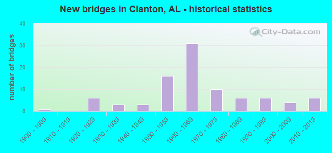
- New bridges - historical statistics
- 11900-1909
- 61920-1929
- 31930-1939
- 31940-1949
- 161950-1959
- 311960-1969
- 101970-1979
- 61980-1989
- 61990-1999
- 42000-2009
- 62010-2019
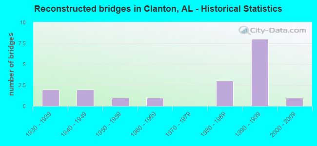
- Reconstructed bridges - Historical Statistics
- 21930-1939
- 21940-1949
- 11950-1959
- 11960-1969
- 01970-1979
- 31980-1989
- 81990-1999
- 12000-2009
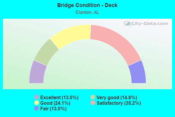
- Bridge Condition - Deck
- 13.0%Excellent
- 14.8%Very good
- 24.1%Good
- 35.2%Satisfactory
- 13.0%Fair
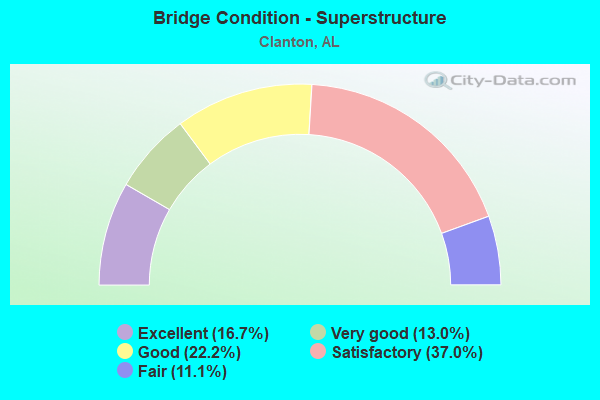
- Bridge Condition - Superstructure
- 16.7%Excellent
- 13.0%Very good
- 22.2%Good
- 37.0%Satisfactory
- 11.1%Fair
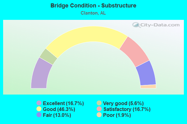
- Bridge Condition - Substructure
- 16.7%Excellent
- 5.6%Very good
- 46.3%Good
- 16.7%Satisfactory
- 13.0%Fair
- 1.9%Poor
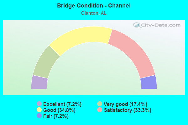
- Bridge Condition - Channel
- 7.2%Excellent
- 17.4%Very good
- 34.8%Good
- 33.3%Satisfactory
- 7.2%Fair
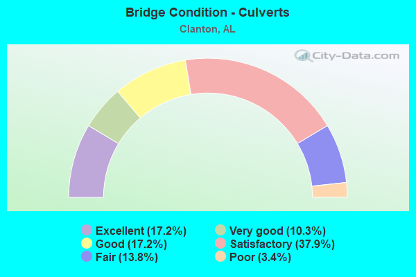
- Bridge Condition - Culverts
- 17.2%Excellent
- 10.3%Very good
- 17.2%Good
- 37.9%Satisfactory
- 13.8%Fair
- 3.4%Poor
Find on map >> Show street view
Structure Number: 20406, Location: 0.5 MI N OF AL 22 (Lat: 32.844583, Lng: -86.639278), Route carried "on" structure: City street , Year Built: 2011, Status: Open, Structure Length: 2.50m (8.20ft), Average Daily Traffic: 2,900 (year 2009), Truck Traffic: 1%, Average Future Daily Traffic: 4,000 (year 2041), Design Load: HS 20, Features Intersected: STREAM, Facility Carried by Structure: 8TH STREET
Minimum Vertical Clearance: 30+ m (98+ ft), Kilometerpoint: 0.000, Lanes on structure: 2, Owner: City or Municipal Highway Agency, Approaching Roadway Width: 8.5m (27.9ft), Material/Design: Concrete, Design/Construction: Channel Beam, Number Of Spans In Main Unit: 1, Number Of Approach Spans: 2, Length of Maximum Span: 10.4m (34.1ft), Curb or Sidewalk Widths: Left: 0.0m, Right: 2.2m (7.2ft), Curb-To-Curb Width: 8.5m (27.9ft), Out-to-Out Width: 11.9m (39.0ft)
Condition: Deck: Good, Superstructure: Good, Substructure: Good, Channel: Good, Operating Rating: 54.7 metric tons, Method Used To Determine Operating Rating: Load Factor (LF), Inventory Rating: 32.8 metric tons, Method Used To Determine Inventory Rating: Load Factor (LF), Structural Evaluation: Better than present minimum criteria, Deck Geometry: Meets minimum limits, Waterway Adequacy: Equal to present desirable criteria, Approach Roadway Alignment: Better than present minimum criteria, Length Of Structure Improvement: 3.38m (11.09ft), Designated Inspection Frequency: Every 24 months, Inspection Date: April 2021, Bridge Improvement Cost: $904,000, Roadway Improvement Cost: $90,000, Total Project Cost: $994,000 ( Estimate for 2022), Deck Structure Type: Concrete Precast Panels
Find on map >> Show street view
Structure Number: 20426, Location: CR359 1.5 MS ANTIOCH CH (Lat: 32.713619, Lng: -86.772494), Route carried "on" structure: County highway 359, Year Built: 2011, Status: Open, Structure Length: 2.07m (6.79ft), Average Daily Traffic: 150 (year 2011), Truck Traffic: 2%, Average Future Daily Traffic: 158 (year 2031), Design Load: HS 20, Features Intersected: BR OF LITTLE MULBERRY CR
Minimum Vertical Clearance: 30+ m (98+ ft), Kilometerpoint: 0.000, Lanes on structure: 2, Owner: County Highway Agency, Approaching Roadway Width: 9.1m (29.9ft), Material/Design: Concrete, Design/Construction: Channel Beam, Number Of Spans In Main Unit: 2, Length of Maximum Span: 10.4m (34.1ft), Curb-To-Curb Width: 8.5m (27.9ft), Out-to-Out Width: 9.3m (30.5ft)
Condition: Deck: Excellent, Superstructure: Excellent, Substructure: Excellent, Channel: Very good, Operating Rating: 64.1 metric tons, Method Used To Determine Operating Rating: Load Factor (LF), Inventory Rating: 38.5 metric tons, Method Used To Determine Inventory Rating: Load Factor (LF), Structural Evaluation: Superior to present desirable criteria, Deck Geometry: Equal to present minimum criteria, Waterway Adequacy: Superior to present desirable criteria, Approach Roadway Alignment: Superior to present desirable criteria, Length Of Structure Improvement: 2.84m (9.32ft), Designated Inspection Frequency: Every 24 months, Inspection Date: January 2022, Bridge Improvement Cost: $584,000, Roadway Improvement Cost: $58,000, Total Project Cost: $642,000 ( Estimate for 2022), Deck Structure Type: Concrete Precast Panels
Find on map >> Show street view
Structure Number: 2053, Location: CR455 1 MN GLAD TIDING CH (Lat: 32.873328, Lng: -86.580750), Route carried "on" structure: County highway , Year Built: 2011, Status: Open, Structure Length: 2.07m (6.79ft), Average Daily Traffic: 125 (year 2010), Average Future Daily Traffic: 150 (year 2028), Design Load: HS 20, Features Intersected: WALNUT CREEK, Facility Carried by Structure: COUNTY ROAD 455
Minimum Vertical Clearance: 30+ m (98+ ft), Kilometerpoint: 0.010, Lanes on structure: 2, Owner: County Highway Agency, Approaching Roadway Width: 8.5m (27.9ft), Material/Design: Concrete, Design/Construction: Channel Beam, Number Of Spans In Main Unit: 2, Length of Maximum Span: 10.4m (34.1ft), Curb-To-Curb Width: 8.5m (27.9ft), Out-to-Out Width: 9.6m (31.5ft)
Condition: Deck: Very good, Superstructure: Excellent, Substructure: Excellent, Channel: Good, Operating Rating: 59.1 metric tons, Method Used To Determine Operating Rating: Load Factor (LF), Inventory Rating: 35.5 metric tons, Method Used To Determine Inventory Rating: Load Factor (LF), Structural Evaluation: Superior to present desirable criteria, Deck Geometry: Equal to present minimum criteria, Waterway Adequacy: Equal to present minimum criteria, Approach Roadway Alignment: Equal to present minimum criteria, Length Of Structure Improvement: 2.84m (9.32ft), Designated Inspection Frequency: Every 24 months, Inspection Date: December 2021, Bridge Improvement Cost: $604,000, Roadway Improvement Cost: $60,000, Total Project Cost: $664,000 ( Estimate for 2022), Deck Structure Type: Concrete Precast Panels, Wearing Surface/Protective System: Wearing Surface: Low Slump Concrete
Find on map >> Show street view
Structure Number: 20531, Location: CR486 1 MI. NO. OAK GROVE (Lat: 32.832531, Lng: -86.555444), Route carried "on" structure: County highway , Year Built: 2011, Status: Open, Structure Length: 1.04m (3.41ft), Average Daily Traffic: 160 (year 2011), Average Future Daily Traffic: 150 (year 2028), Design Load: HS 20, Features Intersected: CARGILE CREEK, Facility Carried by Structure: COUNTY ROAD 486
Minimum Vertical Clearance: 30+ m (98+ ft), Kilometerpoint: 0.010, Lanes on structure: 2, Owner: County Highway Agency, Approaching Roadway Width: 8.5m (27.9ft), Material/Design: Concrete, Design/Construction: Channel Beam, Number Of Spans In Main Unit: 2, Length of Maximum Span: 10.4m (34.1ft), Curb-To-Curb Width: 8.5m (27.9ft), Out-to-Out Width: 9.6m (31.5ft)
Condition: Deck: Very good, Superstructure: Excellent, Substructure: Excellent, Channel: Very good, Operating Rating: 59.1 metric tons, Method Used To Determine Operating Rating: Load Factor (LF), Inventory Rating: 35.5 metric tons, Method Used To Determine Inventory Rating: Load Factor (LF), Structural Evaluation: Superior to present desirable criteria, Deck Geometry: Equal to present minimum criteria, Waterway Adequacy: Equal to present desirable criteria, Approach Roadway Alignment: Equal to present minimum criteria, Length Of Structure Improvement: 1.71m (5.61ft), Designated Inspection Frequency: Every 24 months, Inspection Date: November 2021, Bridge Improvement Cost: $363,000, Roadway Improvement Cost: $36,000, Total Project Cost: $399,000 ( Estimate for 2022), Deck Structure Type: Concrete Precast Panels
Find on map >> Show street view
Structure Number: 21342, Location: _2.9 MI. E. OF LANEVILLE (Lat: 32.773133, Lng: -86.546956), Route carried "on" structure: County highway , Year Built: 2019, Status: Open, Structure Length: 0.76m (2.49ft), Average Daily Traffic: 100 (year 1989), Average Future Daily Traffic: 200 (year 2035), Design Load: HS 20, Features Intersected: _TRIB. TO GREER CREEK, Facility Carried by Structure: _GREER CREEK RD.
Minimum Vertical Clearance: 30+ m (98+ ft), Kilometerpoint: 0.002, Lanes on structure: 1, Owner: County Highway Agency, Approaching Roadway Width: 6.1m (20.0ft), Skew: 3 degrees, Material/Design: Concrete, Design/Construction: Culvert, Number Of Spans In Main Unit: 2, Length of Maximum Span: 3.0m (9.8ft), Curb-To-Curb Width: 4.9m (16.1ft), Out-to-Out Width: 10.7m (35.1ft)
Condition: Channel: Very good, Culverts: Very good, Operating Rating: 74.2 metric tons, Method Used To Determine Operating Rating: Load Factor (LF), Inventory Rating: 44.5 metric tons, Method Used To Determine Inventory Rating: Load Factor (LF), Structural Evaluation: Equal to present desirable criteria, Deck Geometry: High priority of corrective action, Waterway Adequacy: Equal to present desirable criteria, Approach Roadway Alignment: Equal to present desirable criteria, Length Of Structure Improvement: 1.41m (4.63ft), Designated Inspection Frequency: Every 24 months, Inspection Date: September 2021, Bridge Improvement Cost: $286,000, Roadway Improvement Cost: $29,000, Total Project Cost: $315,000 ( Estimate for 2022), Deck Structure Type: Concrete Cast-file-Place
Find on map >> Show street view
Structure Number: 609, Location: 1.3 MI N JCT U S #31 (Lat: 32.819417, Lng: -86.586517), Route carried "under" structure: Interstate 65, Year Built: 1958, Structure Length: 0. m, Average Daily Traffic: 34,110 (year 2013), Truck Traffic: 23%, Features Intersected: I-65, Facility Carried by Structure: COUNTY ROAD 18
Minimum Vertical Clearance: 5.09m (16.70ft), Kilometerpoint: 332.500, Lanes on structure: 2, Lanes under structure: 4, Material/Design: Concrete continuous, Design/Construction: Tee Beam, Length of Maximum Span: 22.3m (73.2ft)
Find on map >> Show street view
Structure Number: 6091, Location: 2.2 MI N JCT US #31 (Lat: 32.832600, Lng: -86.591217), Route carried "under" structure: Interstate 65, Year Built: 1958, Structure Length: 0. m, Average Daily Traffic: 34,110 (year 2013), Truck Traffic: 23%, Features Intersected: I-65, Facility Carried by Structure: COUNTY ROAD 85
Minimum Vertical Clearance: 6.17m (20.24ft), Kilometerpoint: 334.050, Lanes on structure: 2, Lanes under structure: 4, Material/Design: Concrete continuous, Design/Construction: Tee Beam, Length of Maximum Span: 22.3m (73.2ft)
Find on map >> Show street view
Structure Number: 6092, Location: 3.5 MI S JCT SR 145 (Lat: 32.843483, Lng: -86.595250), Route carried "under" structure: Interstate 65, Year Built: 1958, Structure Length: 0. m, Average Daily Traffic: 35,482 (year 2013), Truck Traffic: 23%, Features Intersected: I-65, Facility Carried by Structure: COUNTY ROAD 28
Minimum Vertical Clearance: 5.17m (16.96ft), Kilometerpoint: 335.289, Lanes on structure: 2, Lanes under structure: 4, Material/Design: Concrete continuous, Design/Construction: Tee Beam, Length of Maximum Span: 26.5m (86.9ft)
Find on map >> Show street view
Structure Number: 6093, Location: 3.0 MI S JCT SR 145 (Lat: 32.850233, Lng: -86.597700), Route carried "under" structure: Interstate 65, Year Built: 1958, Structure Length: 0. m, Average Daily Traffic: 35,482 (year 2013), Truck Traffic: 23%, Features Intersected: I-65, Facility Carried by Structure: COUNTY ROAD 32
Minimum Vertical Clearance: 4.92m (16.14ft), Kilometerpoint: 336.074, Lanes on structure: 2, Lanes under structure: 4, Material/Design: Concrete continuous, Design/Construction: Tee Beam, Length of Maximum Span: 22.3m (73.2ft)
Find on map >> Show street view
Structure Number: 6788, Location: 1.4 MI W COOPER (Lat: 32.761983, Lng: -86.560350), Route carried "under" structure: Interstate 65, Year Built: 1960, Structure Length: 0. m, Average Daily Traffic: 34,930 (year 2015), Truck Traffic: 23%, Features Intersected: I-65, Facility Carried by Structure: CO RD 24
Minimum Vertical Clearance: 5.23m (17.16ft), Kilometerpoint: 325.654, Lanes on structure: 2, Lanes under structure: 4, Material/Design: Concrete continuous, Design/Construction: Tee Beam, Length of Maximum Span: 22.3m (73.2ft)
Find on map >> Show street view
Structure Number: 6793, Location: 1.8 MI S JCT 145 (Lat: 32.865083, Lng: -86.607233), Route carried "under" structure: Interstate 65, Year Built: 1960, Structure Length: 0. m, Average Daily Traffic: 35,482 (year 2013), Truck Traffic: 23%, Features Intersected: I-65, Facility Carried by Structure: COUNTY ROAD 51
Minimum Vertical Clearance: 4.95m (16.24ft), Kilometerpoint: 337.957, Lanes on structure: 2, Lanes under structure: 4, Material/Design: Concrete continuous, Design/Construction: Tee Beam, Length of Maximum Span: 22.3m (73.2ft)
Find on map >> Show street view
Structure Number: 6794, Location: 2.5 MI N JCT SR 145 (Lat: 32.918983, Lng: -86.646767), Route carried "under" structure: Interstate 65, Year Built: 1960, Structure Length: 0. m, Average Daily Traffic: 39,800 (year 2013), Truck Traffic: 23%, Features Intersected: I-65, Facility Carried by Structure: COUNTY ROAD 43
Minimum Vertical Clearance: 5.64m (18.50ft), Kilometerpoint: 345.010, Lanes on structure: 2, Lanes under structure: 4, Material/Design: Concrete continuous, Design/Construction: Tee Beam, Length of Maximum Span: 23.8m (78.1ft)
Find on map >> Show street view
Structure Number: 6916, Location: 2.0 MI S CLANTON (Lat: 32.802000, Lng: -86.580200), Route carried "under" structure: Interstate 65, Year Built: 1960, Structure Length: 0. m, Average Daily Traffic: 34,110 (year 2016), Truck Traffic: 23%, Features Intersected: I-65, Facility Carried by Structure: US 31
Minimum Vertical Clearance: 5.95m (19.52ft), Kilometerpoint: 330.468, Lanes on structure: 2, Lanes under structure: 4, Material/Design: Concrete continuous, Design/Construction: Tee Beam, Length of Maximum Span: 23.8m (78.1ft)
Find on map >> Show street view
Structure Number: 7152, Location: 3.7 MI N OF CLANTON (Lat: 32.887800, Lng: -86.624317), Route carried "under" structure: Interstate 65, Year Built: 1960, Structure Length: 0. m, Average Daily Traffic: 39,800 (year 2013), Truck Traffic: 23%, Features Intersected: I-65, Facility Carried by Structure: SR 145
Minimum Vertical Clearance: 5.00m (16.40ft), Kilometerpoint: 340.964, Lanes on structure: 2, Lanes under structure: 4, Material/Design: Concrete continuous, Design/Construction: Tee Beam, Length of Maximum Span: 25.9m (85.0ft)