Bridge Statistics for Clayton, North Carolina (NC)
Condition, Traffic, Stress, Structural Evaluation, Project Costs
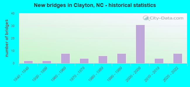
- New bridges - historical statistics
- 21940-1949
- 21950-1959
- 81960-1969
- 41970-1979
- 61980-1989
- 81990-1999
- 312000-2009
- 42010-2019
- 82020-2022


- Bridge Condition - Deck
- 5.3%Very good
- 63.2%Good
- 28.9%Satisfactory
- 2.6%Fair

- Bridge Condition - Superstructure
- 2.6%Excellent
- 34.2%Very good
- 31.6%Good
- 15.8%Satisfactory
- 13.2%Fair
- 2.6%Poor

- Bridge Condition - Substructure
- 28.9%Very good
- 26.3%Good
- 21.1%Satisfactory
- 15.8%Fair
- 7.9%Poor

- Bridge Condition - Channel
- 63.9%Good
- 30.6%Satisfactory
- 5.6%Fair

- Bridge Condition - Culverts
- 7.7%Very good
- 30.8%Good
- 38.5%Satisfactory
- 15.4%Fair
- 7.7%Poor
Find on map >> Show street view
Structure Number: 1010599, Location: .93 M. NORTH.JCT.NC42 (Lat: 35.629886, Lng: -78.536158), Route carried "on" structure: State highway 1525, Year Built: 2007, Status: Open, Structure Length: 7.95m (26.08ft), Average Daily Traffic: 12,500 (year 2018), Truck Traffic: 7%, Average Future Daily Traffic: 25,000 (year 2040), Design Load: HS 20+Mod, Features Intersected: US70 BYP
Minimum Vertical Clearance: 30+ m (98+ ft), Kilometerpoint: 0.000, Lanes on structure: 2, Lanes under structure: 4, Owner: State Highway Agency, Approaching Roadway Width: 7.3m (24.0ft), Material/Design: Steel continuous, Design/Construction: Stringer/Multi-beam, Number Of Spans In Main Unit: 2, Length of Maximum Span: 45.4m (149.0ft), Curb-To-Curb Width: 9.2m (30.2ft), Out-to-Out Width: 10.1m (33.1ft)
Condition: Deck: Good, Superstructure: Very good, Substructure: Good, Operating Rating: 89.8 metric tons, Method Used To Determine Operating Rating: Load Factor (LF), Inventory Rating: 55.3 metric tons, Method Used To Determine Inventory Rating: Load Factor (LF), Structural Evaluation: Better than present minimum criteria, Deck Geometry: High priority of corrective action, Underclear: Equal to present minimum criteria, Approach Roadway Alignment: Equal to present desirable criteria, Designated Inspection Frequency: Every 24 months, Inspection Date: January 2022, Deck Structure Type: Concrete Cast-file-Place, Wearing Surface/Protective System: Wearing Surface: Monolithic Concrete, Deck Protection: Epoxy Coated Reinforcing
Find on map >> Show street view
Structure Number: 1010602, Location: 1.6MI.E. OF JCT.SR1560 (Lat: 35.604214, Lng: -78.438044), Route carried "on" structure: Bypass US 70, Year Built: 2008, Status: Open, Structure Length: 3.16m (10.37ft), Average Daily Traffic: 12,000 (year 2011), Truck Traffic: 14%, Average Future Daily Traffic: 24,000 (year 2040), Design Load: HS 20+Mod, Features Intersected: SR1563
Minimum Vertical Clearance: 30+ m (98+ ft), Kilometerpoint: 0.000, Lanes on structure: 2, Lanes under structure: 2, Base Highway Network: Yes (Inventory Route: 2, Subroute: 70), Owner: State Highway Agency, Approaching Roadway Width: 14.6m (47.9ft), Skew: 11 degrees, Material/Design: Prestressed concrete, Design/Construction: Stringer/Multi-beam, Number Of Spans In Main Unit: 1, Length of Maximum Span: 30.1m (98.8ft), Curb-To-Curb Width: 11.5m (37.7ft), Out-to-Out Width: 12.5m (41.0ft)
Condition: Deck: Good, Superstructure: Good, Substructure: Good, Operating Rating: 89.8 metric tons, Method Used To Determine Operating Rating: Load Factor (LF), Inventory Rating: 43.5 metric tons, Method Used To Determine Inventory Rating: Load Factor (LF), Structural Evaluation: Better than present minimum criteria, Deck Geometry: High priority of corrective action, Underclear: Somewhat better than minimum adequacy, Approach Roadway Alignment: Equal to present desirable criteria, Designated Inspection Frequency: Every 24 months, Inspection Date: March 2022, Deck Structure Type: Concrete Cast-file-Place, Wearing Surface/Protective System: Wearing Surface: Monolithic Concrete, Deck Protection: Epoxy Coated Reinforcing
Find on map >> Show street view
Structure Number: 1010606, Location: 1.3 MI. E. JCT. SR1553 (Lat: 35.603511, Lng: -78.415628), Route carried "on" structure: Ramp US 70, Year Built: 2008, Status: Open, Structure Length: 7.25m (23.79ft), Average Daily Traffic: 5,000 (year 2018), Truck Traffic: 14%, Average Future Daily Traffic: 10,000 (year 2040), Design Load: HS 20+Mod, Features Intersected: US70BUS.
Minimum Vertical Clearance: 30+ m (98+ ft), Kilometerpoint: 0.000, Lanes on structure: 2, Lanes under structure: 4, Owner: State Highway Agency, Approaching Roadway Width: 14.3m (46.9ft), Skew: 3 degrees, Material/Design: Steel continuous, Design/Construction: Stringer/Multi-beam, Number Of Spans In Main Unit: 2, Length of Maximum Span: 27.4m (89.9ft), Curb-To-Curb Width: 13.1m (43.0ft), Out-to-Out Width: 14.1m (46.3ft)
Condition: Deck: Good, Superstructure: Very good, Substructure: Very good, Operating Rating: 89.8 metric tons, Method Used To Determine Operating Rating: Load Factor (LF), Inventory Rating: 53.5 metric tons, Method Used To Determine Inventory Rating: Load Factor (LF), Structural Evaluation: Equal to present desirable criteria, Deck Geometry: High priority of corrective action, Underclear: Somewhat better than minimum adequacy, Approach Roadway Alignment: Equal to present desirable criteria, Designated Inspection Frequency: Every 24 months, Inspection Date: March 2022, Deck Structure Type: Concrete Cast-file-Place, Wearing Surface/Protective System: Wearing Surface: Monolithic Concrete, Deck Protection: Epoxy Coated Reinforcing
Find on map >> Show street view
Structure Number: 101062, Location: 0.01 MI. W. JCT. SR2307 (Lat: 35.491500, Lng: -78.270361), Route carried "on" structure: Business US 7, Year Built: 2017, Status: Open, Structure Length: 9.08m (29.79ft), Average Daily Traffic: 8,100 (year 2019), Truck Traffic: 8%, Average Future Daily Traffic: 16,200 (year 2040), Design Load: HL 93, Features Intersected: US70BYP
Minimum Vertical Clearance: 30+ m (98+ ft), Kilometerpoint: 0.000, Lanes on structure: 4, Lanes under structure: 9, Base Highway Network: Yes (Inventory Route: 2, Subroute: 70), Owner: State Highway Agency, Approaching Roadway Width: 8.5m (27.9ft), Skew: 24 degrees, Material/Design: Steel, Design/Construction: Stringer/Multi-beam, Number Of Spans In Main Unit: 2, Length of Maximum Span: 44.5m (146.0ft), Curb-To-Curb Width: 20.7m (67.9ft), Out-to-Out Width: 21.6m (70.9ft)
Condition: Deck: Very good, Superstructure: Excellent, Substructure: Very good, Operating Rating: 73.4 metric tons, Method Used To Determine Operating Rating: Load and Resistance Factor (LRFR), Inventory Rating: 56.2 metric tons, Method Used To Determine Inventory Rating: Load and Resistance Factor (LRFR), Structural Evaluation: Equal to present desirable criteria, Deck Geometry: Superior to present desirable criteria, Underclear: Meets minimum limits, Approach Roadway Alignment: Equal to present desirable criteria, Designated Inspection Frequency: Every 24 months, Inspection Date: November 2021, Deck Structure Type: Concrete Cast-file-Place, Wearing Surface/Protective System: Wearing Surface: Monolithic Concrete, Deck Protection: Epoxy Coated Reinforcing
Find on map >> Show street view
Structure Number: 1010622, Location: 0.4 MI. N. JCT. SR1913 (Lat: 35.613056, Lng: -78.403611), Route carried "on" structure: State highway 2850, Year Built: 2018, Status: Open, Structure Length: 3.47m (11.38ft), Average Daily Traffic: 700 (year 2017), Truck Traffic: 6%, Average Future Daily Traffic: 1,400 (year 2040), Design Load: HL 93, Features Intersected: NCRR/NORFOLK OUTHERN
Minimum Vertical Clearance: 30+ m (98+ ft), Kilometerpoint: 0.000, Lanes on structure: 2, Owner: State Highway Agency, Approaching Roadway Width: 9.7m (31.8ft), Material/Design: Prestressed concrete, Design/Construction: Stringer/Multi-beam, Number Of Spans In Main Unit: 1, Length of Maximum Span: 33.5m (109.9ft), Curb-To-Curb Width: 9.1m (29.9ft), Out-to-Out Width: 10.1m (33.1ft)
Condition: Deck: Good, Superstructure: Very good, Substructure: Good, Operating Rating: 89.8 metric tons, Method Used To Determine Operating Rating: Load and Resistance Factor (LRFR), Inventory Rating: 55.3 metric tons, Method Used To Determine Inventory Rating: Load and Resistance Factor (LRFR), Structural Evaluation: Better than present minimum criteria, Deck Geometry: Equal to present minimum criteria, Underclear: Superior to present desirable criteria, Approach Roadway Alignment: Equal to present desirable criteria, Designated Inspection Frequency: Every 24 months, Inspection Date: October 2021, Deck Structure Type: Concrete Cast-file-Place, Wearing Surface/Protective System: Wearing Surface: Monolithic Concrete, Deck Protection: Epoxy Coated Reinforcing
Find on map >> Show street view
Structure Number: 1010652, Location: 0.5 MI. E. JCT. SR1010 (Lat: 35.606844, Lng: -78.564144), Route carried "on" structure: State highway 42, Year Built: 2022, Status: Closed, Structure Length: 8.59m (28.18ft), Average Daily Traffic: 33,000 (year 2018), Truck Traffic: 6%, Average Future Daily Traffic: 66,000 (year 2040), Design Load: HL 93, Features Intersected: I40
Minimum Vertical Clearance: 30+ m (98+ ft), Kilometerpoint: 0.000, Lanes on structure: 2, Lanes under structure: 6, Owner: State Highway Agency, Approaching Roadway Width: 18.5m (60.7ft), Material/Design: Prestressed concrete, Design/Construction: Stringer/Multi-beam, Number Of Spans In Main Unit: 2, Length of Maximum Span: 42.0m (137.8ft), Curb or Sidewalk Widths: Left: 0.0m, Right: 3.2m (10.5ft), Curb-To-Curb Width: 18.6m (61.0ft), Out-to-Out Width: 19.4m (63.6ft)
Condition: Deck: Good, Superstructure: Good, Substructure: Very good, Operating Rating: 83.4 metric tons, Method Used To Determine Operating Rating: Load and Resistance Factor (LRFR), Inventory Rating: 54.4 metric tons, Method Used To Determine Inventory Rating: Load and Resistance Factor (LRFR), Structural Evaluation: Better than present minimum criteria, Deck Geometry: Superior to present desirable criteria, Approach Roadway Alignment: Equal to present desirable criteria, Designated Inspection Frequency: Every 24 months, Inspection Date: December 2021, Deck Structure Type: Concrete Cast-file-Place, Wearing Surface/Protective System: Wearing Surface: Monolithic Concrete, Deck Protection: Epoxy Coated Reinforcing
Find on map >> Show street view
Structure Number: 1010775, Location: 1.49 MI. W. JCT. SR1003 (Lat: 35.650000, Lng: -78.371139), Route carried "on" structure: State highway 42, Year Built: 2020, Status: Open, Structure Length: 0.76m (2.49ft), Average Daily Traffic: 13,000 (year 2019), Truck Traffic: 6%, Average Future Daily Traffic: 26,000 (year 2040), Design Load: HL 93, Features Intersected: MILL CREEK
Minimum Vertical Clearance: 30+ m (98+ ft), Kilometerpoint: 0.000, Lanes on structure: 3, Owner: State Highway Agency, Approaching Roadway Width: 12.1m (39.7ft), Material/Design: Concrete continuous, Design/Construction: Culvert, Number Of Spans In Main Unit: 2, Length of Maximum Span: 3.6m (11.8ft)
Condition: Channel: Good, Culverts: Very good, Operating Rating: 89.8 metric tons, Method Used To Determine Operating Rating: Load and Resistance Factor (LRFR), Inventory Rating: 69.8 metric tons, Method Used To Determine Inventory Rating: Load and Resistance Factor (LRFR), Structural Evaluation: Equal to present desirable criteria, Waterway Adequacy: Better than present minimum criteria, Approach Roadway Alignment: Equal to present desirable criteria, Designated Inspection Frequency: Every 24 months, Inspection Date: May 2021
Find on map >> Show street view
Structure Number: 101001, Location: JCT. OF US70 & NC42E (Lat: 35.645567, Lng: -78.462672), Route carried "under" structure: State highway 42, Year Built: 1966, Structure Length: 0. m, Average Daily Traffic: 17,500 (year 2019), Truck Traffic: 6%, Features Intersected: US70E
Minimum Vertical Clearance: 4.54m (14.90ft), Kilometerpoint: 0.000, Lanes on structure: 2, Lanes under structure: 2, Material/Design: Steel, Design/Construction: Stringer/Multi-beam, Length of Maximum Span: 20.7m (67.9ft)
Find on map >> Show street view
Structure Number: 1010012, Location: JCT. US70 & NC42 WBL (Lat: 35.645681, Lng: -78.462553), Route carried "under" structure: State highway 42, Year Built: 1966, Structure Length: 0. m, Average Daily Traffic: 17,500 (year 2019), Truck Traffic: 6%, Features Intersected: US70W
Minimum Vertical Clearance: 4.41m (14.47ft), Kilometerpoint: 0.000, Lanes on structure: 3, Lanes under structure: 2, Material/Design: Steel, Design/Construction: Stringer/Multi-beam, Length of Maximum Span: 20.7m (67.9ft)
Find on map >> Show street view
Structure Number: 10105, Location: 0.85 MI .E. JCT. NC42 (Lat: 35.598108, Lng: -78.565039), Route carried "under" structure: Interstate 40, Year Built: 2021, Structure Length: 0. m, Average Daily Traffic: 32,000 (year 2019), Truck Traffic: 16%, Features Intersected: SR1010
Minimum Vertical Clearance: 0.00m, Kilometerpoint: 0.000, Lanes on structure: 2, Lanes under structure: 2, Material/Design: Prestressed concrete, Design/Construction: Stringer/Multi-beam, Length of Maximum Span: 46.6m (152.9ft)
Find on map >> Show street view
Structure Number: 1010501, Location: 0.6 MI.E. JCT.SR1010 (Lat: 35.606969, Lng: -78.564253), Route carried "under" structure: Interstate 40, Year Built: 1987, Structure Length: 0. m, Average Daily Traffic: 32,500 (year 2018), Truck Traffic: 16%, Features Intersected: NC42
Minimum Vertical Clearance: 5.61m (18.41ft), Kilometerpoint: 95.190, Lanes on structure: 3, Lanes under structure: 2, Material/Design: Prestressed concrete, Design/Construction: Channel Beam, Length of Maximum Span: 19.2m (63.0ft)
Find on map >> Show street view
Structure Number: 1010501, Location: 0.6 MI.E. JCT.SR1010 (Lat: 35.606969, Lng: -78.564253), Route carried "under" structure: Interstate 40, Year Built: 1987, Structure Length: 0. m, Average Daily Traffic: 32,500 (year 2018), Truck Traffic: 16%, Features Intersected: NC42
Minimum Vertical Clearance: 5.02m (16.47ft), Kilometerpoint: 95.190, Lanes on structure: 3, Lanes under structure: 3, Material/Design: Prestressed concrete, Design/Construction: Channel Beam, Length of Maximum Span: 19.2m (63.0ft)
Find on map >> Show street view
Structure Number: 1010581, Location: 2.79M. W. JCT. SR1560 (Lat: 35.623642, Lng: -78.510436), Route carried "under" structure: Bypass US 70, Year Built: 2008, Structure Length: 0. m, Average Daily Traffic: 18,250 (year 2018), Truck Traffic: 12%, Features Intersected: NC42
Minimum Vertical Clearance: 5.33m (17.49ft), Kilometerpoint: 0.000, Lanes on structure: 5, Lanes under structure: 2, Material/Design: Steel continuous, Design/Construction: Stringer/Multi-beam, Length of Maximum Span: 36.2m (118.8ft)
Find on map >> Show street view
Structure Number: 1010581, Location: 2.79M. W. JCT. SR1560 (Lat: 35.623642, Lng: -78.510436), Route carried "under" structure: Bypass US 70, Year Built: 2008, Structure Length: 0. m, Average Daily Traffic: 18,250 (year 2018), Truck Traffic: 12%, Features Intersected: NC42
Minimum Vertical Clearance: 5.53m (18.14ft), Kilometerpoint: 0.000, Lanes on structure: 5, Lanes under structure: 2, Material/Design: Steel continuous, Design/Construction: Stringer/Multi-beam, Length of Maximum Span: 36.2m (118.8ft)
Find on map >> Show street view
Structure Number: 1010582, Location: 0.6 MI. S. JCT. SR1552 (Lat: 35.621111, Lng: -78.496350), Route carried "under" structure: Bypass US 70, Year Built: 2006, Structure Length: 0. m, Average Daily Traffic: 15,500 (year 2019), Truck Traffic: 12%, Features Intersected: SR1554
Minimum Vertical Clearance: 6.60m (21.65ft), Kilometerpoint: 97.933, Lanes on structure: 2, Lanes under structure: 2, Material/Design: Steel continuous, Design/Construction: Stringer/Multi-beam, Length of Maximum Span: 38.4m (126.0ft)
Find on map >> Show street view
Structure Number: 1010582, Location: 0.6 MI. S. JCT. SR1552 (Lat: 35.621111, Lng: -78.496350), Route carried "under" structure: Bypass US 70, Year Built: 2006, Structure Length: 0. m, Average Daily Traffic: 15,500 (year 2019), Truck Traffic: 12%, Features Intersected: SR1554
Minimum Vertical Clearance: 6.47m (21.23ft), Kilometerpoint: 97.933, Lanes on structure: 2, Lanes under structure: 2, Material/Design: Steel continuous, Design/Construction: Stringer/Multi-beam, Length of Maximum Span: 38.4m (126.0ft)
Find on map >> Show street view
Structure Number: 1010583, Location: 1.6 MI.E. OF JCT.NC42 (Lat: 35.616744, Lng: -78.483478), Route carried "under" structure: State highway 1555, Year Built: 2008, Structure Length: 0. m, Average Daily Traffic: 4,700 (year 2012), Truck Traffic: 7%, Features Intersected: US70 BYP WBL
Minimum Vertical Clearance: 5.15m (16.90ft), Kilometerpoint: 0.000, Lanes on structure: 2, Lanes under structure: 2, Material/Design: Steel, Design/Construction: Stringer/Multi-beam, Length of Maximum Span: 35.3m (115.8ft)
Find on map >> Show street view
Structure Number: 1010584, Location: 1.6 MI.E. OF JCT.NC42 (Lat: 35.616450, Lng: -78.483497), Route carried "under" structure: State highway 1555, Year Built: 2008, Structure Length: 0. m, Average Daily Traffic: 5,100 (year 2016), Truck Traffic: 7%, Features Intersected: US70E.BYP
Minimum Vertical Clearance: 5.76m (18.90ft), Kilometerpoint: 0.000, Lanes on structure: 2, Lanes under structure: 2, Material/Design: Steel, Design/Construction: Stringer/Multi-beam, Length of Maximum Span: 34.7m (113.8ft)
Find on map >> Show street view
Structure Number: 1010585, Location: 1.3 MI.E. OF JCT.SR1554 (Lat: 35.611906, Lng: -78.463006), Route carried "under" structure: State highway 1560, Year Built: 2008, Structure Length: 0. m, Average Daily Traffic: 5,000 (year 2018), Truck Traffic: 7%, Features Intersected: US70 BYP WBL
Minimum Vertical Clearance: 6.32m (20.73ft), Kilometerpoint: 0.000, Lanes on structure: 2, Lanes under structure: 6, Material/Design: Prestressed concrete continuous, Design/Construction: Stringer/Multi-beam, Length of Maximum Span: 28.0m (91.9ft)
Find on map >> Show street view
Structure Number: 1010586, Location: 1.3 MI.E. JCT. SR1554 (Lat: 35.611694, Lng: -78.463292), Route carried "under" structure: State highway 1560, Year Built: 2008, Structure Length: 0. m, Average Daily Traffic: 5,000 (year 2018), Features Intersected: US70 BYP EBL
Minimum Vertical Clearance: 5.51m (18.08ft), Kilometerpoint: 0.000, Lanes on structure: 2, Lanes under structure: 5, Material/Design: Prestressed concrete continuous, Design/Construction: Stringer/Multi-beam, Length of Maximum Span: 28.0m (91.9ft)
Find on map >> Show street view
Structure Number: 1010599, Location: .93 M. NORTH.JCT.NC42 (Lat: 35.629886, Lng: -78.536158), Route carried "under" structure: Bypass US 70, Year Built: 2007, Structure Length: 0. m, Average Daily Traffic: 16,250 (year 2019), Truck Traffic: 12%, Features Intersected: SR1525
Minimum Vertical Clearance: 6.09m (19.98ft), Kilometerpoint: 97.232, Lanes on structure: 2, Lanes under structure: 2, Material/Design: Steel continuous, Design/Construction: Stringer/Multi-beam, Length of Maximum Span: 45.4m (149.0ft)
Find on map >> Show street view
Structure Number: 1010599, Location: .93 M. NORTH.JCT.NC42 (Lat: 35.629886, Lng: -78.536158), Route carried "under" structure: Bypass US 70, Year Built: 2007, Structure Length: 0. m, Average Daily Traffic: 16,250 (year 2019), Truck Traffic: 12%, Features Intersected: SR1525
Minimum Vertical Clearance: 5.66m (18.57ft), Kilometerpoint: 97.232, Lanes on structure: 2, Lanes under structure: 2, Material/Design: Steel continuous, Design/Construction: Stringer/Multi-beam, Length of Maximum Span: 45.4m (149.0ft)
Find on map >> Show street view
Structure Number: 1010602, Location: 1.6MI.E. OF JCT.SR1560 (Lat: 35.604214, Lng: -78.438044), Route carried "under" structure: State highway 1563, Year Built: 2008, Structure Length: 0. m, Average Daily Traffic: 3,400 (year 2017), Truck Traffic: 7%, Features Intersected: US70BYP WBL
Minimum Vertical Clearance: 4.85m (15.91ft), Kilometerpoint: 0.000, Lanes on structure: 2, Lanes under structure: 2, Material/Design: Prestressed concrete, Design/Construction: Stringer/Multi-beam, Length of Maximum Span: 30.1m (98.8ft)
Find on map >> Show street view
Structure Number: 1010606, Location: 1.3 MI. E. JCT. SR1553 (Lat: 35.603511, Lng: -78.415628), Route carried "under" structure: Business US 70, Year Built: 2008, Structure Length: 0. m, Average Daily Traffic: 7,500 (year 2018), Truck Traffic: 12%, Features Intersected: US70W.RAMP
Minimum Vertical Clearance: 5.76m (18.90ft), Kilometerpoint: 0.000, Lanes on structure: 2, Lanes under structure: 2, Material/Design: Steel continuous, Design/Construction: Stringer/Multi-beam, Length of Maximum Span: 27.4m (89.9ft)
Find on map >> Show street view
Structure Number: 1010606, Location: 1.3 MI. E. JCT. SR1553 (Lat: 35.603511, Lng: -78.415628), Route carried "under" structure: Business US 70, Year Built: 2008, Structure Length: 0. m, Average Daily Traffic: 7,500 (year 2018), Truck Traffic: 12%, Features Intersected: US70W.RAMP
Minimum Vertical Clearance: 6.12m (20.08ft), Kilometerpoint: 0.000, Lanes on structure: 2, Lanes under structure: 2, Material/Design: Steel continuous, Design/Construction: Stringer/Multi-beam, Length of Maximum Span: 27.4m (89.9ft)
Find on map >> Show street view
Structure Number: 1010652, Location: 0.5 MI. E. JCT. SR1010 (Lat: 35.606844, Lng: -78.564144), Route carried "under" structure: Interstate 40, Year Built: 2022, Structure Length: 0. m, Average Daily Traffic: 30,000 (year 2018), Truck Traffic: 16%, Features Intersected: NC42(CLOSED)
Minimum Vertical Clearance: 6.61m (21.69ft), Kilometerpoint: 0.000, Lanes on structure: 2, Lanes under structure: 2, Material/Design: Prestressed concrete, Design/Construction: Stringer/Multi-beam, Length of Maximum Span: 42.0m (137.8ft)
Find on map >> Show street view
Structure Number: 1010652, Location: 0.5 MI. E. JCT. SR1010 (Lat: 35.606844, Lng: -78.564144), Route carried "under" structure: Interstate 40, Year Built: 2022, Structure Length: 0. m, Average Daily Traffic: 30,000 (year 2018), Truck Traffic: 16%, Features Intersected: NC42(CLOSED)
Minimum Vertical Clearance: 6.21m (20.37ft), Kilometerpoint: 0.000, Lanes on structure: 2, Lanes under structure: 2, Material/Design: Prestressed concrete, Design/Construction: Stringer/Multi-beam, Length of Maximum Span: 42.0m (137.8ft)
Find on map >> Show street view
Structure Number: 1010652, Location: 0.5 MI. E. JCT. SR1010 (Lat: 35.606844, Lng: -78.564144), Route carried "under" structure: Interstate 40, Year Built: 2022, Structure Length: 0. m, Average Daily Traffic: 30,000 (year 2018), Truck Traffic: 16%, Features Intersected: NC42(CLOSED)
Minimum Vertical Clearance: 6.61m (21.69ft), Kilometerpoint: 0.000, Lanes on structure: 2, Lanes under structure: 2, Material/Design: Prestressed concrete, Design/Construction: Stringer/Multi-beam, Length of Maximum Span: 42.0m (137.8ft)