Bridge Statistics for Clearwater, Kansas (KS)
Condition, Traffic, Stress, Structural Evaluation, Project Costs
- National Bridge Inventory (NBI) Statistics
- 52Number of bridges
- 423ft / 129mTotal length
- $4,712,000Total costs
- 25,867Total average daily traffic
- 1,410Total average daily truck traffic
- 31,869Total future (year 2038) average daily traffic
- National Bridge Inventory (NBI) Registered Bridges for Clearwater
- No street view available for this location
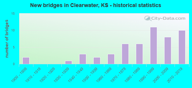
- New bridges - historical statistics
- 21900-1909
- 11930-1939
- 31940-1949
- 21950-1959
- 31960-1969
- 61970-1979
- 61980-1989
- 111990-1999
- 82000-2009
- 102010-2019

- Reconstructed bridges - Historical Statistics
- 11990-1999
- 12000-2009


- Bridge Condition - Deck
- 19.0%Very good
- 42.9%Good
- 14.3%Satisfactory
- 19.0%Fair
- 4.8%Poor

- Bridge Condition - Superstructure
- 33.3%Very good
- 23.8%Good
- 23.8%Satisfactory
- 9.5%Fair
- 9.5%Poor

- Bridge Condition - Substructure
- 23.8%Very good
- 38.1%Good
- 23.8%Satisfactory
- 14.3%Poor

- Bridge Condition - Channel
- 17.3%Very good
- 28.8%Good
- 34.6%Satisfactory
- 11.5%Fair
- 7.7%Poor

- Bridge Condition - Culverts
- 22.6%Very good
- 45.2%Good
- 12.9%Satisfactory
- 9.7%Fair
- 9.7%Poor
Find on map >> Show street view
Structure Number: 87018, Location: 183rdW, 0.4 N of 111thS (Lat: 37.493975, Lng: -97.551186), Route carried "on" structure: County highway 604, Year Built: 1975, Status: Open, Structure Length: 1.01m (3.31ft), Average Daily Traffic: 624 (year 2018), Truck Traffic: 10%, Average Future Daily Traffic: 761 (year 2038), Design Load: H 20, Features Intersected: TRIB. TO NINNESCAH RIVER
Minimum Vertical Clearance: 30.47m (99.97ft), Kilometerpoint: 0.000, Lanes on structure: 2, Owner: County Highway Agency, Approaching Roadway Width: 9.1m (29.9ft), Material/Design: Concrete, Design/Construction: Culvert, Number Of Spans In Main Unit: 3, Length of Maximum Span: 3.4m (11.2ft), Curb-To-Curb Width: 10.9m (35.8ft), Out-to-Out Width: 11.6m (38.1ft)
Condition: Channel: Good, Culverts: Fair, Operating Rating: 30.0 metric tons, Method Used To Determine Operating Rating: Load Factor (LF), Inventory Rating: 18.0 metric tons, Method Used To Determine Inventory Rating: Load Factor (LF), Structural Evaluation: Somewhat better than minimum adequacy, Deck Geometry: Equal to present minimum criteria, Waterway Adequacy: Better than present minimum criteria, Approach Roadway Alignment: Equal to present desirable criteria, Designated Inspection Frequency: Every 24 months, Inspection Date: June 2020, Deck Structure Type: Concrete Cast-file-Place, Wearing Surface/Protective System: Wearing Surface: Bituminous
Find on map >> Show street view
Structure Number: 87025, Location: 151stW, 0.9 N of 119thS (Lat: 37.490386, Lng: -97.531575), Route carried "on" structure: County highway 602, Year Built: 1955, Year Reconstructed: 2011, Status: Posted for load, Structure Length: 18.93m (62.11ft), Average Daily Traffic: 768 (year 2018), Truck Traffic: 7%, Average Future Daily Traffic: 937 (year 2038), Design Load: H 20, Features Intersected: NINNESCAH RIVER
Minimum Vertical Clearance: 30.47m (99.97ft), Kilometerpoint: 0.000, Lanes on structure: 2, Owner: County Highway Agency, Approaching Roadway Width: 12.5m (41.0ft), Material/Design: Steel continuous, Design/Construction: Stringer/Multi-beam, Number Of Spans In Main Unit: 7, Length of Maximum Span: 27.4m (89.9ft), Curb-To-Curb Width: 7.9m (25.9ft), Out-to-Out Width: 8.9m (29.2ft)
Condition: Deck: Poor, Superstructure: Poor, Substructure: Poor, Channel: Poor, Operating Rating: 40.2 metric tons, Method Used To Determine Operating Rating: Load Factor (LF), Inventory Rating: 24.0 metric tons, Method Used To Determine Inventory Rating: Load Factor (LF), Structural Evaluation: Meets minimum limits, Deck Geometry: Somewhat better than minimum adequacy, Waterway Adequacy: Somewhat better than minimum adequacy, Approach Roadway Alignment: Equal to present minimum criteria, Length Of Structure Improvement: 21.34m (70.01ft), Designated Inspection Frequency: Every 24 months, Other Special Inspection Frequency: Every 12 months, Inspection Date: June 2020, Other Special Inspection Date: May 2021, Bridge Improvement Cost: $1,000,000, Roadway Improvement Cost: $200,000, Total Project Cost: $1,000,000 ( Estimate for 2018), Deck Structure Type: Concrete Cast-file-Place, Wearing Surface/Protective System: Wearing Surface: Low Slump Concrete
Find on map >> Show street view
Structure Number: 870264, Location: 135thW, 0.6 N of 71stS (Lat: 37.571222, Lng: -97.497917), Route carried "on" structure: County highway 6040, Year Built: 2014, Status: Open, Structure Length: 0.75m (2.46ft), Average Daily Traffic: 3,874 (year 2018), Truck Traffic: 3%, Average Future Daily Traffic: 4,726 (year 2038), Design Load: HL 93, Features Intersected: SPRING CREEK, Facility Carried by Structure: RS 604 135thW
Minimum Vertical Clearance: 30.47m (99.97ft), Kilometerpoint: 0.000, Lanes on structure: 2, Owner: County Highway Agency, Approaching Roadway Width: 12.1m (39.7ft), Material/Design: Concrete, Design/Construction: Culvert, Number Of Spans In Main Unit: 2, Length of Maximum Span: 3.7m (12.1ft), Curb-To-Curb Width: 19.7m (64.6ft), Out-to-Out Width: 20.1m (65.9ft)
Condition: Channel: Very good, Culverts: Good, Operating Rating: 59.0 metric tons, Method Used To Determine Operating Rating: Load and Resistance Factor Rating (LRFR) rating reported by rating factor(RF) method using HL-93 loadings, Inventory Rating: 45.7 metric tons, Method Used To Determine Inventory Rating: Load and Resistance Factor Rating (LRFR) rating reported by rating factor(RF) method using HL-93 loadings, Structural Evaluation: Better than present minimum criteria, Deck Geometry: Superior to present desirable criteria, Waterway Adequacy: Equal to present desirable criteria, Approach Roadway Alignment: Equal to present desirable criteria, Designated Inspection Frequency: Every 24 months, Inspection Date: July 2020, Deck Structure Type: Concrete Cast-file-Place, Wearing Surface/Protective System: Wearing Surface: Bituminous
Find on map >> Show street view
Structure Number: 870266, Location: 135thW, 0.9 N of 79thS (Lat: 37.562361, Lng: -97.497778), Route carried "on" structure: County highway 6040, Year Built: 2014, Status: Open, Structure Length: 0.77m (2.53ft), Average Daily Traffic: 3,929 (year 2018), Truck Traffic: 4%, Average Future Daily Traffic: 4,793 (year 2038), Design Load: HL 93, Features Intersected: TRIB TO SPRING CREEK, Facility Carried by Structure: RS 604 135thW
Minimum Vertical Clearance: 30.47m (99.97ft), Kilometerpoint: 0.000, Lanes on structure: 2, Owner: County Highway Agency, Approaching Roadway Width: 12.1m (39.7ft), Material/Design: Concrete, Design/Construction: Culvert, Number Of Spans In Main Unit: 3, Length of Maximum Span: 2.4m (7.9ft), Curb-To-Curb Width: 19.1m (62.7ft), Out-to-Out Width: 19.5m (64.0ft)
Condition: Channel: Very good, Culverts: Very good, Operating Rating: 57.7 metric tons, Method Used To Determine Operating Rating: Load and Resistance Factor Rating (LRFR) rating reported by rating factor(RF) method using HL-93 loadings, Inventory Rating: 44.4 metric tons, Method Used To Determine Inventory Rating: Load and Resistance Factor Rating (LRFR) rating reported by rating factor(RF) method using HL-93 loadings, Structural Evaluation: Equal to present desirable criteria, Deck Geometry: Superior to present desirable criteria, Waterway Adequacy: Equal to present desirable criteria, Approach Roadway Alignment: Equal to present desirable criteria, Designated Inspection Frequency: Every 24 months, Inspection Date: July 2020, Deck Structure Type: Concrete Cast-file-Place, Wearing Surface/Protective System: Wearing Surface: Bituminous
Find on map >> Show street view
Structure Number: 8712, Location: 71stS, 0.7 E of 135thW (Lat: 37.562847, Lng: -97.484867), Route carried "on" structure: County highway 601, Year Built: 1970, Status: Posted for load, Structure Length: 1.25m (4.10ft), Average Daily Traffic: 1,816 (year 2018), Truck Traffic: 14%, Average Future Daily Traffic: 2,216 (year 2038), Design Load: H 20, Features Intersected: SPRING CREEK
Minimum Vertical Clearance: 30.47m (99.97ft), Kilometerpoint: 0.000, Lanes on structure: 2, Owner: County Highway Agency, Approaching Roadway Width: 14.0m (45.9ft), Material/Design: Steel, Design/Construction: Stringer/Multi-beam, Number Of Spans In Main Unit: 1, Length of Maximum Span: 12.2m (40.0ft), Curb-To-Curb Width: 13.4m (44.0ft), Out-to-Out Width: 14.5m (47.6ft)
Condition: Deck: Fair, Superstructure: Satisfactory, Substructure: Poor, Channel: Poor, Operating Rating: 17.6 metric tons, Method Used To Determine Operating Rating: Load Factor (LF), Inventory Rating: 10.5 metric tons, Method Used To Determine Inventory Rating: Load Factor (LF), Structural Evaluation: High priority of replacement, Deck Geometry: Equal to present desirable criteria, Waterway Adequacy: Somewhat better than minimum adequacy, Approach Roadway Alignment: Equal to present desirable criteria, Bridge Posting: Required (Relationship of Operating Rating to Maximum Legal Load: 30.0 - 39.9% below), Length Of Structure Improvement: 15.24m (50.00ft), Designated Inspection Frequency: Every 24 months, Inspection Date: July 2020, Bridge Improvement Cost: $500,000, Roadway Improvement Cost: $150,000, Total Project Cost: $650,000 ( Estimate for 2018), Deck Structure Type: Concrete Cast-file-Place, Wearing Surface/Protective System: Wearing Surface: Bituminous
Find on map >> Show street view
Structure Number: 87128, Location: 103rdS, 0.7 E of 183rdW (Lat: 37.504383, Lng: -97.538356), Route carried "on" structure: County highway 604, Year Built: 2000, Status: Open, Structure Length: 22.11m (72.54ft), Average Daily Traffic: 758 (year 2018), Truck Traffic: 9%, Average Future Daily Traffic: 925 (year 2038), Design Load: HS 20, Features Intersected: NINNESCAH RIVER
Minimum Vertical Clearance: 30.47m (99.97ft), Kilometerpoint: 0.000, Lanes on structure: 2, Owner: County Highway Agency, Approaching Roadway Width: 12.0m (39.4ft), Skew: 3 degrees, Material/Design: Prestressed concrete continuous, Design/Construction: Stringer/Multi-beam, Number Of Spans In Main Unit: 8, Length of Maximum Span: 29.0m (95.1ft), Curb-To-Curb Width: 12.0m (39.4ft), Out-to-Out Width: 12.6m (41.3ft)
Condition: Deck: Good, Superstructure: Very good, Substructure: Good, Channel: Satisfactory, Operating Rating: 49.5 metric tons, Method Used To Determine Operating Rating: Load Factor (LF), Inventory Rating: 32.4 metric tons, Method Used To Determine Inventory Rating: Load Factor (LF), Structural Evaluation: Better than present minimum criteria, Deck Geometry: Better than present minimum criteria, Waterway Adequacy: Better than present minimum criteria, Approach Roadway Alignment: Equal to present desirable criteria, Designated Inspection Frequency: Every 24 months, Inspection Date: June 2020, Deck Structure Type: Concrete Cast-file-Place, Wearing Surface/Protective System: Wearing Surface: Latex Concrete
Find on map >> Show street view
Structure Number: 871285, Location: 103rdS, 0.9 E of 183rdW (Lat: 37.504444, Lng: -97.538889), Route carried "on" structure: County highway 604, Year Built: 2001, Status: Open, Structure Length: 0.77m (2.53ft), Average Daily Traffic: 758 (year 2018), Truck Traffic: 9%, Average Future Daily Traffic: 925 (year 2038), Design Load: HS 20, Features Intersected: TRIB TO NINNESCAH
Minimum Vertical Clearance: 30.47m (99.97ft), Kilometerpoint: 0.000, Lanes on structure: 2, Owner: County Highway Agency, Approaching Roadway Width: 9.1m (29.9ft), Material/Design: Concrete, Design/Construction: Culvert, Number Of Spans In Main Unit: 3, Length of Maximum Span: 2.4m (7.9ft), Curb-To-Curb Width: 10.4m (34.1ft), Out-to-Out Width: 10.9m (35.8ft)
Condition: Channel: Good, Culverts: Good, Operating Rating: 43.5 metric tons, Method Used To Determine Operating Rating: Load Factor (LF), Inventory Rating: 32.7 metric tons, Method Used To Determine Inventory Rating: Load Factor (LF), Structural Evaluation: Better than present minimum criteria, Deck Geometry: Equal to present minimum criteria, Waterway Adequacy: Equal to present desirable criteria, Approach Roadway Alignment: Equal to present desirable criteria, Designated Inspection Frequency: Every 24 months, Inspection Date: July 2020, Deck Structure Type: Concrete Cast-file-Place, Wearing Surface/Protective System: Wearing Surface: Bituminous
Find on map >> Show street view
Structure Number: 87129, Location: 103rdS, 0.5 E of 167thW (Lat: 37.504539, Lng: -97.541706), Route carried "on" structure: County highway 604, Year Built: 2001, Status: Open, Structure Length: 0.97m (3.18ft), Average Daily Traffic: 758 (year 2018), Truck Traffic: 8%, Average Future Daily Traffic: 925 (year 2038), Features Intersected: TRIB. TO NINNESCAH RIVER
Minimum Vertical Clearance: 30.47m (99.97ft), Kilometerpoint: 0.000, Lanes on structure: 2, Owner: County Highway Agency, Approaching Roadway Width: 8.8m (28.9ft), Material/Design: Concrete, Design/Construction: Culvert, Number Of Spans In Main Unit: 3, Length of Maximum Span: 3.0m (9.8ft), Curb-To-Curb Width: 10.1m (33.1ft), Out-to-Out Width: 10.7m (35.1ft)
Condition: Channel: Good, Culverts: Fair, Operating Rating: 43.5 metric tons, Method Used To Determine Operating Rating: Load Factor (LF), Inventory Rating: 32.7 metric tons, Method Used To Determine Inventory Rating: Load Factor (LF), Structural Evaluation: Somewhat better than minimum adequacy, Deck Geometry: Equal to present minimum criteria, Waterway Adequacy: Equal to present minimum criteria, Approach Roadway Alignment: Equal to present desirable criteria, Designated Inspection Frequency: Every 24 months, Inspection Date: June 2020, Deck Structure Type: Concrete Cast-file-Place, Wearing Surface/Protective System: Wearing Surface: Bituminous
Find on map >> Show street view
Structure Number: 8713, Location: 103rdS, 0.9 E of 167thW (Lat: 37.504586, Lng: -97.517567), Route carried "on" structure: County highway 604, Year Built: 2001, Status: Open, Structure Length: 1.68m (5.51ft), Average Daily Traffic: 758 (year 2018), Truck Traffic: 8%, Average Future Daily Traffic: 925 (year 2038), Features Intersected: TRIB. TO NINNESCAH RIVER
Minimum Vertical Clearance: 30.47m (99.97ft), Kilometerpoint: 0.000, Lanes on structure: 2, Owner: County Highway Agency, Approaching Roadway Width: 9.1m (29.9ft), Skew: 2 degrees, Material/Design: Concrete, Design/Construction: Culvert, Number Of Spans In Main Unit: 5, Length of Maximum Span: 3.1m (10.2ft), Curb-To-Curb Width: 10.4m (34.1ft), Out-to-Out Width: 10.8m (35.4ft)
Condition: Channel: Fair, Culverts: Good, Operating Rating: 43.5 metric tons, Method Used To Determine Operating Rating: Load Factor (LF), Inventory Rating: 32.7 metric tons, Method Used To Determine Inventory Rating: Load Factor (LF), Structural Evaluation: Better than present minimum criteria, Deck Geometry: Equal to present minimum criteria, Waterway Adequacy: Equal to present minimum criteria, Approach Roadway Alignment: Equal to present desirable criteria, Designated Inspection Frequency: Every 24 months, Inspection Date: June 2020, Deck Structure Type: Concrete Cast-file-Place, Wearing Surface/Protective System: Wearing Surface: Bituminous
Find on map >> Show street view
Structure Number: 87131, Location: 103rdS, 0.1 E of 151stW (Lat: 37.504600, Lng: -97.529303), Route carried "on" structure: County highway 604, Year Built: 2001, Status: Open, Structure Length: 0.77m (2.53ft), Average Daily Traffic: 800 (year 2018), Truck Traffic: 6%, Average Future Daily Traffic: 976 (year 2038), Design Load: HS 20, Features Intersected: TRIB. TO NINNESCAH RIVER
Minimum Vertical Clearance: 30.47m (99.97ft), Kilometerpoint: 0.000, Lanes on structure: 2, Owner: County Highway Agency, Approaching Roadway Width: 9.1m (29.9ft), Material/Design: Concrete, Design/Construction: Culvert, Number Of Spans In Main Unit: 3, Length of Maximum Span: 2.4m (7.9ft), Curb-To-Curb Width: 10.4m (34.1ft), Out-to-Out Width: 10.8m (35.4ft)
Condition: Channel: Good, Culverts: Good, Operating Rating: 43.5 metric tons, Method Used To Determine Operating Rating: Load Factor (LF), Inventory Rating: 32.7 metric tons, Method Used To Determine Inventory Rating: Load Factor (LF), Structural Evaluation: Better than present minimum criteria, Deck Geometry: Equal to present minimum criteria, Waterway Adequacy: Equal to present desirable criteria, Approach Roadway Alignment: Equal to present desirable criteria, Designated Inspection Frequency: Every 24 months, Inspection Date: June 2020, Deck Structure Type: Concrete Cast-file-Place, Wearing Surface/Protective System: Wearing Surface: Bituminous
Find on map >> Show street view
Structure Number: 87132, Location: 103rdS, 0.7 E of 135thW (Lat: 37.504819, Lng: -97.499631), Route carried "on" structure: County highway 602, Year Built: 1940, Status: Open, Structure Length: 1.13m (3.71ft), Average Daily Traffic: 2,544 (year 2018), Truck Traffic: 4%, Average Future Daily Traffic: 3,200 (year 2038), Features Intersected: TRIB. TO NINNESCAH RIVER
Minimum Vertical Clearance: 30.47m (99.97ft), Kilometerpoint: 0.000, Lanes on structure: 2, Owner: County Highway Agency, Approaching Roadway Width: 9.1m (29.9ft), Material/Design: Concrete, Design/Construction: Culvert, Number Of Spans In Main Unit: 4, Length of Maximum Span: 2.7m (8.9ft), Curb-To-Curb Width: 9.1m (29.9ft), Out-to-Out Width: 9.9m (32.5ft)
Condition: Channel: Fair, Culverts: Poor, Operating Rating: 22.5 metric tons, Method Used To Determine Operating Rating: Load Factor (LF), Inventory Rating: 17.1 metric tons, Method Used To Determine Inventory Rating: Load Factor (LF), Structural Evaluation: Meets minimum limits, Deck Geometry: Meets minimum limits, Waterway Adequacy: Somewhat better than minimum adequacy, Approach Roadway Alignment: Better than present minimum criteria, Length Of Structure Improvement: 7.62m (25.00ft), Designated Inspection Frequency: Every 24 months, Inspection Date: July 2020, Bridge Improvement Cost: $250,000, Roadway Improvement Cost: $100,000, Total Project Cost: $350,000 ( Estimate for 2018), Deck Structure Type: Concrete Cast-file-Place, Wearing Surface/Protective System: Wearing Surface: Bituminous
Find on map >> Show street view
Structure Number: 87133, Location: 103rdS, 0.5 E of 119thW (Lat: 37.504942, Lng: -97.468667), Route carried "on" structure: County highway 602, Year Built: 1940, Status: Open, Structure Length: 1.16m (3.81ft), Average Daily Traffic: 1,770 (year 2018), Truck Traffic: 8%, Average Future Daily Traffic: 2,160 (year 2038), Features Intersected: TRIB. TO NINNESCAH RIVER
Minimum Vertical Clearance: 30.47m (99.97ft), Kilometerpoint: 0.000, Lanes on structure: 2, Owner: County Highway Agency, Approaching Roadway Width: 10.7m (35.1ft), Material/Design: Concrete, Design/Construction: Culvert, Number Of Spans In Main Unit: 4, Length of Maximum Span: 2.7m (8.9ft), Curb-To-Curb Width: 9.1m (29.9ft), Out-to-Out Width: 9.9m (32.5ft)
Condition: Channel: Fair, Culverts: Poor, Operating Rating: 22.5 metric tons, Method Used To Determine Operating Rating: Load Factor (LF), Inventory Rating: 17.1 metric tons, Method Used To Determine Inventory Rating: Load Factor (LF), Structural Evaluation: Meets minimum limits, Deck Geometry: Somewhat better than minimum adequacy, Waterway Adequacy: Somewhat better than minimum adequacy, Approach Roadway Alignment: Equal to present minimum criteria, Length Of Structure Improvement: 7.62m (25.00ft), Designated Inspection Frequency: Every 24 months, Inspection Date: July 2020, Bridge Improvement Cost: $350,000, Roadway Improvement Cost: $100,000, Total Project Cost: $450,000 ( Estimate for 2016), Deck Structure Type: Concrete Cast-file-Place, Wearing Surface/Protective System: Wearing Surface: Bituminous
Find on map >> Show street view
Structure Number: 96016, Location: 0.8N 2.3E OF MILLERTON (Lat: 37.448389, Lng: -97.514100), Route carried "on" structure: County highway 602, Year Built: 1930, Status: Posted for load, Structure Length: 0.70m (2.30ft), Average Daily Traffic: 601 (year 2013), Average Future Daily Traffic: 625 (year 2041), Features Intersected: TRIB. TO TURTLE CREEK
Minimum Vertical Clearance: 30.47m (99.97ft), Kilometerpoint: 0.000, Lanes on structure: 2, Owner: County Highway Agency, Approaching Roadway Width: 7.9m (25.9ft), Material/Design: Concrete, Design/Construction: Culvert, Number Of Spans In Main Unit: 3, Length of Maximum Span: 2.1m (6.9ft), Curb-To-Curb Width: 7.7m (25.3ft), Out-to-Out Width: 7.9m (25.9ft)
Condition: Channel: Satisfactory, Culverts: Good, Operating Rating: 38.7 metric tons, Method Used To Determine Operating Rating: Load Factor (LF), Inventory Rating: 23.4 metric tons, Method Used To Determine Inventory Rating: Load Factor (LF), Structural Evaluation: Equal to present minimum criteria, Deck Geometry: Meets minimum limits, Waterway Adequacy: Somewhat better than minimum adequacy, Approach Roadway Alignment: Equal to present desirable criteria, Designated Inspection Frequency: Every 24 months, Inspection Date: June 2021
Find on map >> Show street view
Structure Number: 870795006427, Location: 199thW, 0.3 N of 103rdS (Lat: 37.508394, Lng: -97.569844), Route carried "on" structure: County highway , Year Built: 1997, Status: Posted for load, Structure Length: 1.65m (5.41ft), Average Daily Traffic: 40 (year 2018), Average Future Daily Traffic: 60 (year 2038), Features Intersected: SPRING CREEK, Facility Carried by Structure: 199th LOCAL RD.
Minimum Vertical Clearance: 30.47m (99.97ft), Kilometerpoint: 0.000, Lanes on structure: 2, Owner: County Highway Agency, Approaching Roadway Width: 6.0m (19.7ft), Material/Design: Wood or Timber, Design/Construction: Stringer/Multi-beam, Number Of Spans In Main Unit: 3, Length of Maximum Span: 5.8m (19.0ft), Curb-To-Curb Width: 7.0m (23.0ft), Out-to-Out Width: 7.3m (24.0ft)
Condition: Deck: Satisfactory, Superstructure: Fair, Substructure: Good, Channel: Fair, Operating Rating: 15.1 metric tons, Method Used To Determine Operating Rating: Load Factor (LF), Inventory Rating: 9.8 metric tons, Method Used To Determine Inventory Rating: Load Factor (LF), Structural Evaluation: High priority of replacement, Deck Geometry: Somewhat better than minimum adequacy, Waterway Adequacy: Somewhat better than minimum adequacy, Approach Roadway Alignment: Better than present minimum criteria, Length Of Structure Improvement: 9.14m (29.99ft), Designated Inspection Frequency: Every 24 months, Inspection Date: June 2020, Bridge Improvement Cost: $500,000, Roadway Improvement Cost: $100,000, Total Project Cost: $600,000 ( Estimate for 2018), Deck Structure Type: Wood or Timber, Wearing Surface/Protective System: Wearing Surface: Gravel
Find on map >> Show street view
Structure Number: 870795006464, Location: 199thW, 0.6 N of 119thS (Lat: 37.483544, Lng: -97.569539), Route carried "on" structure: County highway , Year Built: 1997, Status: Open, Structure Length: 1.86m (6.10ft), Average Daily Traffic: 30 (year 2018), Average Future Daily Traffic: 50 (year 2038), Design Load: HS 20, Features Intersected: TRIB. TO NINNESCAH RIVER, Facility Carried by Structure: 199th LOCAL RD.
Minimum Vertical Clearance: 30.47m (99.97ft), Kilometerpoint: 0.000, Lanes on structure: 2, Owner: County Highway Agency, Approaching Roadway Width: 8.5m (27.9ft), Skew: 3 degrees, Material/Design: Concrete, Design/Construction: Culvert, Number Of Spans In Main Unit: 5, Length of Maximum Span: 3.7m (12.1ft), Curb-To-Curb Width: 8.5m (27.9ft), Out-to-Out Width: 9.0m (29.5ft)
Condition: Channel: Satisfactory, Culverts: Good, Operating Rating: 40.5 metric tons, Method Used To Determine Operating Rating: Load Factor (LF), Inventory Rating: 32.4 metric tons, Method Used To Determine Inventory Rating: Load Factor (LF), Structural Evaluation: Better than present minimum criteria, Deck Geometry: Better than present minimum criteria, Waterway Adequacy: Better than present minimum criteria, Approach Roadway Alignment: Better than present minimum criteria, Designated Inspection Frequency: Every 24 months, Inspection Date: June 2020, Deck Structure Type: Concrete Cast-file-Place, Wearing Surface/Protective System: Wearing Surface: Monolithic Concrete
Find on map >> Show street view
Structure Number: 870797006407, Location: 183rdW, 0.3 N of 95thS (Lat: 37.522547, Lng: -97.551356), Route carried "on" structure: County highway , Year Built: 1976, Status: Open, Structure Length: 1.04m (3.41ft), Average Daily Traffic: 440 (year 2018), Truck Traffic: 6%, Average Future Daily Traffic: 537 (year 2038), Design Load: H 20, Features Intersected: TRIB. TO NINNESCAH RIVER, Facility Carried by Structure: 183rd LOCAL RD.
Minimum Vertical Clearance: 30.47m (99.97ft), Kilometerpoint: 0.000, Lanes on structure: 2, Owner: County Highway Agency, Approaching Roadway Width: 10.0m (32.8ft), Skew: 3 degrees, Material/Design: Concrete, Design/Construction: Culvert, Number Of Spans In Main Unit: 3, Length of Maximum Span: 3.4m (11.2ft), Curb-To-Curb Width: 11.1m (36.4ft), Out-to-Out Width: 11.5m (37.7ft)
Condition: Channel: Satisfactory, Culverts: Satisfactory, Operating Rating: 22.5 metric tons, Method Used To Determine Operating Rating: Load Factor (LF), Inventory Rating: 17.1 metric tons, Method Used To Determine Inventory Rating: Load Factor (LF), Structural Evaluation: Somewhat better than minimum adequacy, Deck Geometry: Better than present minimum criteria, Waterway Adequacy: Equal to present minimum criteria, Approach Roadway Alignment: Equal to present desirable criteria, Designated Inspection Frequency: Every 24 months, Inspection Date: July 2020, Deck Structure Type: Other, Wearing Surface/Protective System: Wearing Surface: Bituminous
Find on map >> Show street view
Structure Number: 870797006461, Location: 183rdW, 0.9 N of 119thS (Lat: 37.489067, Lng: -97.551206), Route carried "on" structure: County highway , Year Built: 1964, Status: Posted for load, Structure Length: 1.16m (3.81ft), Average Daily Traffic: 101 (year 2018), Truck Traffic: 12%, Average Future Daily Traffic: 130 (year 2038), Features Intersected: TRIB. TO NINNESCAH RIVER, Facility Carried by Structure: 183rd LOCAL RD.
Minimum Vertical Clearance: 30.47m (99.97ft), Kilometerpoint: 0.000, Lanes on structure: 2, Owner: County Highway Agency, Approaching Roadway Width: 8.5m (27.9ft), Material/Design: Concrete, Design/Construction: Tee Beam, Number Of Spans In Main Unit: 1, Length of Maximum Span: 11.3m (37.1ft), Curb-To-Curb Width: 7.9m (25.9ft), Out-to-Out Width: 9.1m (29.9ft)
Condition: Deck: Fair, Superstructure: Fair, Substructure: Satisfactory, Channel: Poor, Operating Rating: 17.1 metric tons, Method Used To Determine Operating Rating: Load Factor (LF), Inventory Rating: 11.7 metric tons, Method Used To Determine Inventory Rating: Load Factor (LF), Structural Evaluation: Meets minimum limits, Deck Geometry: Somewhat better than minimum adequacy, Waterway Adequacy: Equal to present minimum criteria, Approach Roadway Alignment: Equal to present minimum criteria, Bridge Posting: Required (Relationship of Operating Rating to Maximum Legal Load: 10.0 - 19.9% below), Length Of Structure Improvement: 12.19m (39.99ft), Designated Inspection Frequency: Every 24 months, Inspection Date: June 2020, Bridge Improvement Cost: $500,000, Roadway Improvement Cost: $100,000, Total Project Cost: $600,000 ( Estimate for 2018), Deck Structure Type: Concrete Cast-file-Place, Wearing Surface/Protective System: Wearing Surface: Bituminous
Find on map >> Show street view
Structure Number: 870797006468, Location: 183rdW, 0.1 N of 119thS (Lat: 37.476831, Lng: -97.551250), Route carried "on" structure: County highway 2514, Year Built: 2017, Status: Open, Structure Length: 1.33m (4.36ft), Average Daily Traffic: 102 (year 2018), Truck Traffic: 12%, Average Future Daily Traffic: 124 (year 2038), Design Load: HS 20, Features Intersected: TRIB. TO NINNESCAH RIVER, Facility Carried by Structure: 183rd LOCAL RD.
Minimum Vertical Clearance: 30.47m (99.97ft), Kilometerpoint: 0.000, Lanes on structure: 2, Owner: County Highway Agency, Approaching Roadway Width: 7.9m (25.9ft), Material/Design: Concrete, Design/Construction: Culvert, Number Of Spans In Main Unit: 4, Length of Maximum Span: 3.0m (9.8ft), Curb-To-Curb Width: 10.5m (34.4ft), Out-to-Out Width: 11.2m (36.7ft)
Condition: Channel: Very good, Culverts: Very good, Operating Rating: 44.1 metric tons, Method Used To Determine Operating Rating: Load Factor (LF), Inventory Rating: 33.9 metric tons, Method Used To Determine Inventory Rating: Load Factor (LF), Structural Evaluation: Equal to present desirable criteria, Deck Geometry: Better than present minimum criteria, Waterway Adequacy: Equal to present minimum criteria, Approach Roadway Alignment: Equal to present desirable criteria, Designated Inspection Frequency: Every 24 months, Inspection Date: June 2020, Deck Structure Type: Concrete Cast-file-Place, Wearing Surface/Protective System: Wearing Surface: Bituminous
Find on map >> Show street view
Structure Number: 8707972064, Location: 87thS, 0.3E of 183rdW (Lat: 37.533281, Lng: -97.547611), Route carried "on" structure: County highway 2135, Year Built: 2018, Status: Open, Structure Length: 0.99m (3.25ft), Average Daily Traffic: 20 (year 2018), Average Future Daily Traffic: 30 (year 2038), Design Load: HS 20, Features Intersected: TRIB. TO NINNESCAH, Facility Carried by Structure: 87thS LOCAL RD.
Minimum Vertical Clearance: 30.47m (99.97ft), Kilometerpoint: 0.000, Lanes on structure: 2, Owner: County Highway Agency, Approaching Roadway Width: 5.4m (17.7ft), Material/Design: Concrete, Design/Construction: Culvert, Number Of Spans In Main Unit: 3, Length of Maximum Span: 3.0m (9.8ft), Curb-To-Curb Width: 8.7m (28.5ft), Out-to-Out Width: 9.3m (30.5ft)
Condition: Channel: Very good, Culverts: Very good, Operating Rating: 43.5 metric tons, Method Used To Determine Operating Rating: Load Factor (LF), Inventory Rating: 32.7 metric tons, Method Used To Determine Inventory Rating: Load Factor (LF), Structural Evaluation: Equal to present desirable criteria, Deck Geometry: Better than present minimum criteria, Waterway Adequacy: Equal to present minimum criteria, Approach Roadway Alignment: Equal to present desirable criteria, Designated Inspection Frequency: Every 24 months, Inspection Date: June 2020, Deck Structure Type: Concrete Cast-file-Place, Wearing Surface/Protective System: Wearing Surface: Gravel
Find on map >> Show street view
Structure Number: 8707977064, Location: 87thS, 0.7E of 183rdW (Lat: 37.533361, Lng: -97.539889), Route carried "on" structure: County highway 2135, Year Built: 2018, Status: Open, Structure Length: 1.35m (4.43ft), Average Daily Traffic: 20 (year 2018), Average Future Daily Traffic: 30 (year 2038), Design Load: HS 20, Features Intersected: TRIB. TO NINNESCAH, Facility Carried by Structure: 87thS LOCAL RD.
Minimum Vertical Clearance: 30.47m (99.97ft), Kilometerpoint: 0.000, Lanes on structure: 2, Owner: County Highway Agency, Approaching Roadway Width: 5.0m (16.4ft), Material/Design: Concrete, Design/Construction: Culvert, Number Of Spans In Main Unit: 4, Length of Maximum Span: 3.0m (9.8ft), Curb-To-Curb Width: 10.5m (34.4ft), Out-to-Out Width: 11.2m (36.7ft)
Condition: Channel: Very good, Culverts: Very good, Operating Rating: 43.5 metric tons, Method Used To Determine Operating Rating: Load Factor (LF), Inventory Rating: 32.7 metric tons, Method Used To Determine Inventory Rating: Load Factor (LF), Structural Evaluation: Equal to present desirable criteria, Deck Geometry: Superior to present desirable criteria, Waterway Adequacy: Better than present minimum criteria, Approach Roadway Alignment: Equal to present desirable criteria, Designated Inspection Frequency: Every 24 months, Inspection Date: June 2020, Deck Structure Type: Concrete Cast-file-Place, Wearing Surface/Protective System: Wearing Surface: Gravel
Find on map >> Show street view
Structure Number: 87079780642, Location: 95thS, 0.8 E of 183rdW (Lat: 37.518653, Lng: -97.536339), Route carried "on" structure: County highway , Year Built: 1976, Status: Open, Structure Length: 1.65m (5.41ft), Average Daily Traffic: 488 (year 2018), Truck Traffic: 4%, Average Future Daily Traffic: 595 (year 2038), Design Load: H 20, Features Intersected: TRIB. TO NINNESCAH RIVER, Facility Carried by Structure: 95th LOCAL RD.
Minimum Vertical Clearance: 30.47m (99.97ft), Kilometerpoint: 0.000, Lanes on structure: 2, Owner: County Highway Agency, Approaching Roadway Width: 11.6m (38.1ft), Material/Design: Concrete, Design/Construction: Culvert, Number Of Spans In Main Unit: 5, Length of Maximum Span: 3.4m (11.2ft), Curb-To-Curb Width: 10.9m (35.8ft), Out-to-Out Width: 11.4m (37.4ft)
Condition: Channel: Good, Culverts: Good, Operating Rating: 27.9 metric tons, Method Used To Determine Operating Rating: Load Factor (LF), Inventory Rating: 22.5 metric tons, Method Used To Determine Inventory Rating: Load Factor (LF), Structural Evaluation: Equal to present minimum criteria, Deck Geometry: Equal to present minimum criteria, Waterway Adequacy: Equal to present minimum criteria, Approach Roadway Alignment: Equal to present desirable criteria, Designated Inspection Frequency: Every 24 months, Inspection Date: June 2020, Deck Structure Type: Concrete Cast-file-Place, Wearing Surface/Protective System: Wearing Surface: Bituminous
Find on map >> Show street view
Structure Number: 87079950642, Location: 95thS, 0.6E OF 167thW (Lat: 37.518639, Lng: -97.521939), Route carried "on" structure: County highway 3189, Year Built: 2018, Status: Open, Structure Length: 4.33m (14.21ft), Average Daily Traffic: 528 (year 2018), Truck Traffic: 4%, Average Future Daily Traffic: 644 (year 2038), Design Load: HL 93, Features Intersected: TRIB. TO NINNESCAH RIVER, Facility Carried by Structure: 95thS LOCAL RD.
Minimum Vertical Clearance: 30.47m (99.97ft), Kilometerpoint: 0.000, Lanes on structure: 2, Owner: County Highway Agency, Approaching Roadway Width: 7.3m (24.0ft), Material/Design: Concrete continuous, Design/Construction: Slab, Number Of Spans In Main Unit: 1, Length of Maximum Span: 17.1m (56.1ft), Curb-To-Curb Width: 9.7m (31.8ft), Out-to-Out Width: 10.4m (34.1ft)
Condition: Deck: Very good, Superstructure: Very good, Substructure: Very good, Channel: Very good, Operating Rating: 85.1 metric tons, Method Used To Determine Operating Rating: Load and Resistance Factor (LRFR), Inventory Rating: 50.9 metric tons, Method Used To Determine Inventory Rating: Load and Resistance Factor (LRFR), Structural Evaluation: Equal to present desirable criteria, Deck Geometry: Equal to present minimum criteria, Waterway Adequacy: Equal to present desirable criteria, Approach Roadway Alignment: Equal to present desirable criteria, Designated Inspection Frequency: Every 24 months, Inspection Date: June 2020, Deck Structure Type: Concrete Cast-file-Place, Wearing Surface/Protective System: Wearing Surface: Monolithic Concrete, Deck Protection: Epoxy Coated Reinforcing
Find on map >> Show street view
Structure Number: 8707996064, Location: 87thS, 0.6 E of 167thW (Lat: 37.533589, Lng: -97.522431), Route carried "on" structure: County highway , Year Built: 1976, Status: Open, Structure Length: 1.34m (4.40ft), Average Daily Traffic: 50 (year 2018), Average Future Daily Traffic: 80 (year 2038), Design Load: H 20, Features Intersected: TRIB. TO NINNESCAH RIVER, Facility Carried by Structure: 87th LOCAL RD.
Minimum Vertical Clearance: 30.47m (99.97ft), Kilometerpoint: 0.000, Lanes on structure: 2, Owner: County Highway Agency, Approaching Roadway Width: 9.1m (29.9ft), Material/Design: Concrete, Design/Construction: Culvert, Number Of Spans In Main Unit: 4, Length of Maximum Span: 3.4m (11.2ft), Curb-To-Curb Width: 9.7m (31.8ft), Out-to-Out Width: 10.2m (33.5ft)
Condition: Channel: Good, Culverts: Good, Operating Rating: 27.9 metric tons, Method Used To Determine Operating Rating: Load Factor (LF), Inventory Rating: 22.5 metric tons, Method Used To Determine Inventory Rating: Load Factor (LF), Structural Evaluation: Equal to present minimum criteria, Deck Geometry: Better than present minimum criteria, Waterway Adequacy: Better than present minimum criteria, Approach Roadway Alignment: Better than present minimum criteria, Designated Inspection Frequency: Every 24 months, Inspection Date: July 2020, Deck Structure Type: Concrete Cast-file-Place, Wearing Surface/Protective System: Wearing Surface: Monolithic Concrete
Find on map >> Show street view
Structure Number: 8707999064, Location: 87thS, 0.9 E of 167thW (Lat: 37.533333, Lng: -97.515000), Route carried "on" structure: County highway , Year Built: 1989, Status: Posted for load, Structure Length: 0.72m (2.36ft), Average Daily Traffic: 100 (year 2018), Average Future Daily Traffic: 100 (year 2038), Features Intersected: TRIB TO NINNESCAH, Facility Carried by Structure: Local Rd 87thS
Minimum Vertical Clearance: 30.47m (99.97ft), Kilometerpoint: 0.000, Lanes on structure: 2, Owner: County Highway Agency, Approaching Roadway Width: 6.0m (19.7ft), Material/Design: Wood or Timber, Design/Construction: Stringer/Multi-beam, Number Of Spans In Main Unit: 1, Length of Maximum Span: 6.6m (21.7ft), Curb-To-Curb Width: 8.3m (27.2ft), Out-to-Out Width: 8.6m (28.2ft)
Condition: Deck: Fair, Superstructure: Poor, Substructure: Poor, Channel: Fair, Operating Rating: 11.1 metric tons, Method Used To Determine Operating Rating: Allowable Stress (AS), Inventory Rating: 7.2 metric tons, Method Used To Determine Inventory Rating: Allowable Stress (AS), Structural Evaluation: High priority of replacement, Deck Geometry: Equal to present minimum criteria, Waterway Adequacy: Somewhat better than minimum adequacy, Approach Roadway Alignment: Equal to present minimum criteria, Bridge Posting: Required (Relationship of Operating Rating to Maximum Legal Load: > 39.9% below), Length Of Structure Improvement: 10.00m (32.81ft), Designated Inspection Frequency: Every 24 months, Inspection Date: June 2020, Bridge Improvement Cost: $150,000, Roadway Improvement Cost: $50,000, Total Project Cost: $200,000 ( Estimate for 2020), Deck Structure Type: Wood or Timber, Wearing Surface/Protective System: Wearing Surface: Gravel
Find on map >> Show street view
Structure Number: 870801006387, Location: 151stW, 0.3 N of 87thS (Lat: 37.538119, Lng: -97.531394), Route carried "on" structure: County highway , Year Built: 1976, Status: Open, Structure Length: 0.94m (3.08ft), Average Daily Traffic: 50 (year 2018), Average Future Daily Traffic: 80 (year 2038), Design Load: H 20, Features Intersected: TRIB. TO NINNESCAH RIVER, Facility Carried by Structure: 151st LOCAL RD.
Minimum Vertical Clearance: 30.47m (99.97ft), Kilometerpoint: 0.000, Lanes on structure: 2, Owner: County Highway Agency, Approaching Roadway Width: 9.1m (29.9ft), Skew: 4 degrees, Material/Design: Concrete, Design/Construction: Culvert, Number Of Spans In Main Unit: 2, Length of Maximum Span: 4.6m (15.1ft), Curb-To-Curb Width: 8.6m (28.2ft), Out-to-Out Width: 9.1m (29.9ft)
Condition: Channel: Good, Culverts: Good, Operating Rating: 22.5 metric tons, Method Used To Determine Operating Rating: Load Factor (LF), Inventory Rating: 17.1 metric tons, Method Used To Determine Inventory Rating: Load Factor (LF), Structural Evaluation: Somewhat better than minimum adequacy, Deck Geometry: Better than present minimum criteria, Waterway Adequacy: Better than present minimum criteria, Approach Roadway Alignment: Better than present minimum criteria, Designated Inspection Frequency: Every 24 months, Inspection Date: June 2020, Deck Structure Type: Concrete Cast-file-Place, Wearing Surface/Protective System: Wearing Surface: Gravel
Find on map >> Show street view
Structure Number: 870801006421, Location: 151stW, 0.9 N of 103rdS (Lat: 37.517217, Lng: -97.531317), Route carried "on" structure: County highway , Year Built: 1900, Status: Open, Structure Length: 0.67m (2.20ft), Average Daily Traffic: 50 (year 2018), Average Future Daily Traffic: 80 (year 2038), Features Intersected: TRIB. TO NINNESCAH RIVER, Facility Carried by Structure: 151st LOCAL RD.
Minimum Vertical Clearance: 30.47m (99.97ft), Kilometerpoint: 0.000, Lanes on structure: 2, Owner: County Highway Agency, Approaching Roadway Width: 7.6m (24.9ft), Material/Design: Concrete, Design/Construction: Culvert, Number Of Spans In Main Unit: 4, Length of Maximum Span: 1.8m (5.9ft), Curb-To-Curb Width: 5.9m (19.4ft), Out-to-Out Width: 6.7m (22.0ft)
Condition: Channel: Fair, Culverts: Fair, Operating Rating: 22.5 metric tons, Method Used To Determine Operating Rating: Load Factor (LF), Inventory Rating: 17.1 metric tons, Method Used To Determine Inventory Rating: Load Factor (LF), Structural Evaluation: Somewhat better than minimum adequacy, Deck Geometry: Meets minimum limits, Waterway Adequacy: High priority of corrective action, Approach Roadway Alignment: Somewhat better than minimum adequacy, Length Of Structure Improvement: 0.91m (2.99ft), Designated Inspection Frequency: Every 24 months, Inspection Date: June 2020, Bridge Improvement Cost: $90,000, Roadway Improvement Cost: $50,000, Total Project Cost: $140,000 ( Estimate for 2020), Deck Structure Type: Concrete Cast-file-Place, Wearing Surface/Protective System: Wearing Surface: Gravel
Find on map >> Show street view
Structure Number: 87080110642, Location: 95thS, 0.1 E of 151stW (Lat: 37.518611, Lng: -97.512500), Route carried "on" structure: County highway , Year Built: 2012, Status: Open, Structure Length: 0.62m (2.03ft), Average Daily Traffic: 545 (year 2018), Truck Traffic: 9%, Average Future Daily Traffic: 725 (year 2038), Design Load: HS 20, Features Intersected: TRIB TO NINNESCAH, Facility Carried by Structure: Local Rd 95thS
Minimum Vertical Clearance: 30.47m (99.97ft), Kilometerpoint: 0.000, Lanes on structure: 2, Owner: County Highway Agency, Approaching Roadway Width: 7.9m (25.9ft), Material/Design: Concrete, Design/Construction: Culvert, Number Of Spans In Main Unit: 3, Length of Maximum Span: 1.8m (5.9ft), Curb-To-Curb Width: 9.3m (30.5ft), Out-to-Out Width: 9.9m (32.5ft)
Condition: Channel: Satisfactory, Culverts: Good, Operating Rating: 43.5 metric tons, Method Used To Determine Operating Rating: Load Factor (LF), Inventory Rating: 32.7 metric tons, Method Used To Determine Inventory Rating: Load Factor (LF), Structural Evaluation: Better than present minimum criteria, Deck Geometry: Equal to present minimum criteria, Waterway Adequacy: Equal to present desirable criteria, Approach Roadway Alignment: Better than present minimum criteria, Designated Inspection Frequency: Every 24 months, Inspection Date: June 2020, Deck Structure Type: Concrete Cast-file-Place, Wearing Surface/Protective System: Wearing Surface: Bituminous
Find on map >> Show street view
Structure Number: 870801506428, Location: 0.1N OF CLEARWATER (Lat: 37.509225, Lng: -97.504786), Route carried "on" structure: County highway , Year Built: 1948, Status: Open, Structure Length: 1.89m (6.20ft), Average Daily Traffic: 345 (year 2018), Truck Traffic: 3%, Average Future Daily Traffic: 421 (year 2038), Features Intersected: TRIB. TO NINNESCAH RIVER, Facility Carried by Structure: Tracy St LOCAL RD.
Minimum Vertical Clearance: 30.47m (99.97ft), Kilometerpoint: 0.000, Lanes on structure: 2, Owner: County Highway Agency, Approaching Roadway Width: 9.3m (30.5ft), Skew: 5 degrees, Material/Design: Concrete, Design/Construction: Culvert, Number Of Spans In Main Unit: 4, Length of Maximum Span: 4.6m (15.1ft), Curb-To-Curb Width: 9.5m (31.2ft), Out-to-Out Width: 9.8m (32.2ft)
Condition: Channel: Satisfactory, Culverts: Poor, Operating Rating: 22.5 metric tons, Method Used To Determine Operating Rating: Load Factor (LF), Inventory Rating: 17.1 metric tons, Method Used To Determine Inventory Rating: Load Factor (LF), Structural Evaluation: Meets minimum limits, Deck Geometry: Equal to present minimum criteria, Waterway Adequacy: Somewhat better than minimum adequacy, Approach Roadway Alignment: Somewhat better than minimum adequacy, Length Of Structure Improvement: 6.10m (20.01ft), Designated Inspection Frequency: Every 24 months, Inspection Date: June 2020, Bridge Improvement Cost: $300,000, Roadway Improvement Cost: $100,000, Total Project Cost: $400,000 ( Estimate for 2018), Deck Structure Type: Concrete Cast-file-Place, Wearing Surface/Protective System: Wearing Surface: Bituminous
Find on map >> Show street view
Structure Number: 87080170648, Location: 119thS, 0.7 E of 151stW (Lat: 37.475722, Lng: -97.501508), Route carried "on" structure: County highway , Year Built: 1994, Status: Open, Structure Length: 2.83m (9.28ft), Average Daily Traffic: 50 (year 2018), Average Future Daily Traffic: 80 (year 2038), Design Load: HS 20, Features Intersected: TRIB. TO NINNESCAH RIVER, Facility Carried by Structure: 119th LOCAL RD.
Minimum Vertical Clearance: 30.47m (99.97ft), Kilometerpoint: 0.000, Lanes on structure: 2, Owner: County Highway Agency, Approaching Roadway Width: 8.5m (27.9ft), Material/Design: Concrete continuous, Design/Construction: Slab, Number Of Spans In Main Unit: 3, Length of Maximum Span: 11.0m (36.1ft), Curb-To-Curb Width: 8.5m (27.9ft), Out-to-Out Width: 9.1m (29.9ft)
Condition: Deck: Very good, Superstructure: Very good, Substructure: Very good, Channel: Satisfactory, Operating Rating: 65.9 metric tons, Method Used To Determine Operating Rating: Load Factor (LF), Inventory Rating: 39.4 metric tons, Method Used To Determine Inventory Rating: Load Factor (LF), Structural Evaluation: Equal to present desirable criteria, Deck Geometry: Better than present minimum criteria, Waterway Adequacy: Equal to present minimum criteria, Approach Roadway Alignment: Equal to present desirable criteria, Designated Inspection Frequency: Every 24 months, Inspection Date: June 2020, Other Special Inspection Date: Febuary 2021, Deck Structure Type: Concrete Cast-file-Place, Wearing Surface/Protective System: Wearing Surface: Monolithic Concrete
Find on map >> Show street view
Structure Number: 870803006441, Location: 135thW(Cwtr),0.1 S 103rd (Lat: 37.502833, Lng: -97.496833), Route carried "on" structure: Other road 19785, Year Built: 1987, Year Reconstructed: 1995, Status: Open, Structure Length: 0.74m (2.43ft), Average Daily Traffic: 1,000 (year 2018), Truck Traffic: 1%, Average Future Daily Traffic: 1,200 (year 2038), Design Load: HS 20, Features Intersected: TRIB TO NINNESCAH, Facility Carried by Structure: Local Rd-Clearwtr
Minimum Vertical Clearance: 30.47m (99.97ft), Kilometerpoint: 0.000, Lanes on structure: 2, Owner: County Highway Agency, Approaching Roadway Width: 11.0m (36.1ft), Skew: 4 degrees, Material/Design: Concrete, Design/Construction: Culvert, Number Of Spans In Main Unit: 2, Length of Maximum Span: 3.6m (11.8ft), Curb or Sidewalk Widths: Left: 1.2m (3.9ft), Right: 1.6m (5.2ft), Curb-To-Curb Width: 11.0m (36.1ft), Out-to-Out Width: 14.3m (46.9ft)
Condition: Channel: Very good, Culverts: Good, Operating Rating: 43.5 metric tons, Method Used To Determine Operating Rating: Load Factor (LF), Inventory Rating: 32.7 metric tons, Method Used To Determine Inventory Rating: Load Factor (LF), Structural Evaluation: Better than present minimum criteria, Deck Geometry: Better than present minimum criteria, Waterway Adequacy: Equal to present minimum criteria, Approach Roadway Alignment: Somewhat better than minimum adequacy, Designated Inspection Frequency: Every 24 months, Inspection Date: July 2020, Deck Structure Type: Concrete Cast-file-Place, Wearing Surface/Protective System: Wearing Surface: Bituminous
Find on map >> Show street view
Structure Number: 870803006469, Location: 135thW, 0.1 N of 119thS (Lat: 37.476639, Lng: -97.496611), Route carried "on" structure: County highway , Year Built: 2002, Status: Open, Structure Length: 3.12m (10.24ft), Average Daily Traffic: 50 (year 2018), Average Future Daily Traffic: 80 (year 2038), Design Load: HS 20, Features Intersected: TRIB. TO NINNESCAH RIVER, Facility Carried by Structure: LOCAL RD.
Minimum Vertical Clearance: 30.47m (99.97ft), Kilometerpoint: 0.000, Lanes on structure: 2, Owner: County Highway Agency, Approaching Roadway Width: 8.5m (27.9ft), Material/Design: Prestressed concrete continuous, Design/Construction: Tee Beam, Number Of Spans In Main Unit: 3, Length of Maximum Span: 12.2m (40.0ft), Curb-To-Curb Width: 8.5m (27.9ft), Out-to-Out Width: 9.1m (29.9ft)
Condition: Deck: Very good, Superstructure: Good, Substructure: Very good, Channel: Good, Operating Rating: 45.0 metric tons, Method Used To Determine Operating Rating: Load Factor (LF), Inventory Rating: 27.0 metric tons, Method Used To Determine Inventory Rating: Load Factor (LF), Structural Evaluation: Equal to present minimum criteria, Deck Geometry: Better than present minimum criteria, Waterway Adequacy: Equal to present minimum criteria, Approach Roadway Alignment: Equal to present desirable criteria, Designated Inspection Frequency: Every 24 months, Inspection Date: June 2020, Deck Structure Type: Concrete Cast-file-Place, Wearing Surface/Protective System: Wearing Surface: Monolithic Concrete
Find on map >> Show street view
Structure Number: 870803106443, Location: ParkGlen, 0.01E of 135thW (Lat: 37.499833, Lng: -97.496556), Route carried "on" structure: Other road 15226, Year Built: 1993, Status: Open, Structure Length: 1.16m (3.81ft), Average Daily Traffic: 500 (year 2018), Average Future Daily Traffic: 600 (year 2038), Design Load: HS 20, Features Intersected: TRIB TO NINNESCAH, Facility Carried by Structure: Local Rd-Clrwater
Minimum Vertical Clearance: 30.47m (99.97ft), Kilometerpoint: 0.000, Lanes on structure: 2, Owner: County Highway Agency, Approaching Roadway Width: 9.5m (31.2ft), Skew: 20 degrees, Material/Design: Concrete, Design/Construction: Culvert, Number Of Spans In Main Unit: 3, Length of Maximum Span: 3.6m (11.8ft), Curb or Sidewalk Widths: Left: 1.2m (3.9ft), Right: 0.0m, Curb-To-Curb Width: 21.4m (70.2ft), Out-to-Out Width: 30.9m (101.4ft)
Condition: Channel: Very good, Culverts: Good, Operating Rating: 93.7 metric tons, Method Used To Determine Operating Rating: Load Factor (LF), Inventory Rating: 56.2 metric tons, Method Used To Determine Inventory Rating: Load Factor (LF), Structural Evaluation: Better than present minimum criteria, Deck Geometry: Superior to present desirable criteria, Waterway Adequacy: Equal to present desirable criteria, Approach Roadway Alignment: Somewhat better than minimum adequacy, Designated Inspection Frequency: Every 24 months, Inspection Date: July 2020, Other Special Inspection Date: Febuary 2021, Deck Structure Type: Concrete Cast-file-Place, Wearing Surface/Protective System: Wearing Surface: Bituminous
Find on map >> Show street view
Structure Number: 87080320632, Location: 55thS, 0.2 E of 135thW (Lat: 37.592022, Lng: -97.511000), Route carried "on" structure: County highway , Year Built: 1988, Status: Open, Structure Length: 0.79m (2.59ft), Average Daily Traffic: 50 (year 2018), Average Future Daily Traffic: 80 (year 2038), Design Load: H 20, Features Intersected: TRIB. TO DRY CREEK, Facility Carried by Structure: 55th LOCAL RD.
Minimum Vertical Clearance: 30.47m (99.97ft), Kilometerpoint: 0.000, Lanes on structure: 2, Owner: County Highway Agency, Approaching Roadway Width: 8.5m (27.9ft), Skew: 4 degrees, Material/Design: Concrete, Design/Construction: Culvert, Number Of Spans In Main Unit: 1, Length of Maximum Span: 7.9m (25.9ft), Curb-To-Curb Width: 8.5m (27.9ft), Out-to-Out Width: 9.1m (29.9ft)
Condition: Channel: Very good, Culverts: Good, Operating Rating: 27.9 metric tons, Method Used To Determine Operating Rating: Load Factor (LF), Inventory Rating: 22.5 metric tons, Method Used To Determine Inventory Rating: Load Factor (LF), Structural Evaluation: Equal to present minimum criteria, Deck Geometry: Better than present minimum criteria, Waterway Adequacy: Equal to present desirable criteria, Approach Roadway Alignment: Better than present minimum criteria, Designated Inspection Frequency: Every 24 months, Inspection Date: August 2020, Deck Structure Type: Concrete Cast-file-Place, Wearing Surface/Protective System: Wearing Surface: Gravel
Find on map >> Show street view
Structure Number: 870805006364, Location: 119thW, 0.6 N of 79thS (Lat: 37.557533, Lng: -97.496333), Route carried "on" structure: County highway , Year Built: 1991, Status: Open, Structure Length: 1.92m (6.30ft), Average Daily Traffic: 50 (year 2018), Average Future Daily Traffic: 80 (year 2038), Design Load: H 20, Features Intersected: SPRING CREEK, Facility Carried by Structure: 119th LOCAL RD.
Minimum Vertical Clearance: 30.47m (99.97ft), Kilometerpoint: 0.000, Lanes on structure: 2, Owner: County Highway Agency, Approaching Roadway Width: 8.5m (27.9ft), Material/Design: Concrete, Design/Construction: Culvert, Number Of Spans In Main Unit: 5, Length of Maximum Span: 3.7m (12.1ft), Curb-To-Curb Width: 8.5m (27.9ft), Out-to-Out Width: 9.1m (29.9ft)
Condition: Channel: Good, Culverts: Good, Operating Rating: 44.4 metric tons, Method Used To Determine Operating Rating: Load Factor (LF), Inventory Rating: 26.6 metric tons, Method Used To Determine Inventory Rating: Load Factor (LF), Structural Evaluation: Equal to present minimum criteria, Deck Geometry: Better than present minimum criteria, Waterway Adequacy: Equal to present minimum criteria, Approach Roadway Alignment: Better than present minimum criteria, Designated Inspection Frequency: Every 24 months, Inspection Date: July 2020, Other Special Inspection Date: Febuary 2021, Deck Structure Type: Concrete Cast-file-Place, Wearing Surface/Protective System: Wearing Surface: Monolithic Concrete
Find on map >> Show street view
Structure Number: 870805006447, Location: 119thW, 0.3 N of 111thS (Lat: 37.494975, Lng: -97.494992), Route carried "on" structure: County highway , Year Built: 1994, Status: Open, Structure Length: 1.92m (6.30ft), Average Daily Traffic: 182 (year 2018), Truck Traffic: 9%, Average Future Daily Traffic: 222 (year 2038), Design Load: HS 20, Features Intersected: SMALL STREAM, Facility Carried by Structure: 119th LOCAL RD.
Minimum Vertical Clearance: 30.47m (99.97ft), Kilometerpoint: 0.000, Lanes on structure: 2, Owner: County Highway Agency, Approaching Roadway Width: 8.5m (27.9ft), Material/Design: Concrete, Design/Construction: Culvert, Number Of Spans In Main Unit: 5, Length of Maximum Span: 4.0m (13.1ft), Curb-To-Curb Width: 8.5m (27.9ft), Out-to-Out Width: 9.0m (29.5ft)
Condition: Channel: Good, Culverts: Very good, Operating Rating: 40.5 metric tons, Method Used To Determine Operating Rating: Load Factor (LF), Inventory Rating: 32.4 metric tons, Method Used To Determine Inventory Rating: Load Factor (LF), Structural Evaluation: Equal to present desirable criteria, Deck Geometry: Equal to present minimum criteria, Waterway Adequacy: Better than present minimum criteria, Approach Roadway Alignment: Equal to present minimum criteria, Designated Inspection Frequency: Every 24 months, Inspection Date: July 2020, Deck Structure Type: Concrete Cast-file-Place, Wearing Surface/Protective System: Wearing Surface: Monolithic Concrete
Find on map >> Show street view
Structure Number: 870807006368, Location: 103rdW, 0.1 N of 79thS (Lat: 37.549472, Lng: -97.461306), Route carried "on" structure: County highway 8755, Year Built: 2014, Status: Open, Structure Length: 0.80m (2.62ft), Average Daily Traffic: 358 (year 2018), Truck Traffic: 6%, Average Future Daily Traffic: 436 (year 2038), Design Load: HS 20, Features Intersected: TRIB TO SPRING CREEK, Facility Carried by Structure: 103rdW, RurMinColl
Minimum Vertical Clearance: 30.47m (99.97ft), Kilometerpoint: 0.000, Lanes on structure: 2, Owner: County Highway Agency, Approaching Roadway Width: 7.3m (24.0ft), Material/Design: Concrete, Design/Construction: Culvert, Number Of Spans In Main Unit: 3, Length of Maximum Span: 2.4m (7.9ft), Curb-To-Curb Width: 10.6m (34.8ft), Out-to-Out Width: 11.1m (36.4ft)
Condition: Channel: Good, Culverts: Very good, Operating Rating: 43.5 metric tons, Method Used To Determine Operating Rating: Load Factor (LF), Inventory Rating: 32.7 metric tons, Method Used To Determine Inventory Rating: Load Factor (LF), Structural Evaluation: Equal to present desirable criteria, Deck Geometry: Better than present minimum criteria, Waterway Adequacy: Equal to present minimum criteria, Approach Roadway Alignment: Better than present minimum criteria, Designated Inspection Frequency: Every 24 months, Inspection Date: July 2020, Deck Structure Type: Concrete Cast-file-Place, Wearing Surface/Protective System: Wearing Surface: Bituminous
Find on map >> Show street view
Structure Number: 870807006441, Location: 103rdW, 0.9 N of 111thS (Lat: 37.503528, Lng: -97.477025), Route carried "on" structure: County highway , Year Built: 1964, Status: Posted for load, Structure Length: 0.79m (2.59ft), Average Daily Traffic: 50 (year 2018), Average Future Daily Traffic: 80 (year 2038), Features Intersected: TRIB. TO NINNESCAH RIVER, Facility Carried by Structure: Maize
Minimum Vertical Clearance: 30.47m (99.97ft), Kilometerpoint: 0.000, Lanes on structure: 2, Owner: County Highway Agency, Approaching Roadway Width: 6.7m (22.0ft), Skew: 1 degrees, Material/Design: Steel, Design/Construction: Culvert, Number Of Spans In Main Unit: 4, Length of Maximum Span: 1.5m (4.9ft), Curb-To-Curb Width: 6.7m (22.0ft), Out-to-Out Width: 6.7m (22.0ft)
Condition: Channel: Good, Culverts: Satisfactory, Operating Rating: 21.9 metric tons, Method Used To Determine Operating Rating: Load Factor (LF), Inventory Rating: 13.1 metric tons, Method Used To Determine Inventory Rating: Load Factor (LF), Structural Evaluation: Meets minimum limits, Deck Geometry: Somewhat better than minimum adequacy, Waterway Adequacy: Equal to present minimum criteria, Approach Roadway Alignment: Better than present minimum criteria, Bridge Posting: Required (Relationship of Operating Rating to Maximum Legal Load: 30.0 - 39.9% below), Designated Inspection Frequency: Every 24 months, Inspection Date: July 2020, Deck Structure Type: Other, Wearing Surface/Protective System: Wearing Surface: Gravel
Find on map >> Show street view
Structure Number: 870807006449, Location: 103rdW, 0.1 N of 111thS (Lat: 37.491181, Lng: -97.476761), Route carried "on" structure: County highway , Year Built: 1998, Status: Open, Structure Length: 2.04m (6.69ft), Average Daily Traffic: 50 (year 2018), Average Future Daily Traffic: 80 (year 2038), Design Load: HS 20, Features Intersected: TRIB. TO NINNESCAH RIVER, Facility Carried by Structure: Maize Rd
Minimum Vertical Clearance: 30.47m (99.97ft), Kilometerpoint: 0.000, Lanes on structure: 2, Owner: County Highway Agency, Approaching Roadway Width: 8.5m (27.9ft), Material/Design: Concrete continuous, Design/Construction: Slab, Number Of Spans In Main Unit: 2, Length of Maximum Span: 9.8m (32.2ft), Curb-To-Curb Width: 8.5m (27.9ft), Out-to-Out Width: 9.1m (29.9ft)
Condition: Deck: Good, Superstructure: Very good, Substructure: Good, Channel: Good, Operating Rating: 55.8 metric tons, Method Used To Determine Operating Rating: Load Factor (LF), Inventory Rating: 33.5 metric tons, Method Used To Determine Inventory Rating: Load Factor (LF), Structural Evaluation: Better than present minimum criteria, Deck Geometry: Better than present minimum criteria, Waterway Adequacy: Equal to present desirable criteria, Approach Roadway Alignment: Equal to present minimum criteria, Designated Inspection Frequency: Every 24 months, Inspection Date: July 2020, Deck Structure Type: Concrete Cast-file-Place, Wearing Surface/Protective System: Wearing Surface: Monolithic Concrete
Find on map >> Show street view
Structure Number: 8708079064, Location: 87thS, 0.9 E of 103rdW (Lat: 37.534467, Lng: -97.459964), Route carried "on" structure: County highway , Year Built: 1994, Status: Open, Structure Length: 3.60m (11.81ft), Average Daily Traffic: 45 (year 2018), Average Future Daily Traffic: 70 (year 2038), Design Load: HS 20, Features Intersected: SPRING CREEK, Facility Carried by Structure: 87th
Minimum Vertical Clearance: 30.47m (99.97ft), Kilometerpoint: 0.000, Lanes on structure: 2, Owner: County Highway Agency, Approaching Roadway Width: 8.5m (27.9ft), Material/Design: Concrete continuous, Design/Construction: Slab, Number Of Spans In Main Unit: 3, Length of Maximum Span: 13.7m (44.9ft), Curb-To-Curb Width: 8.5m (27.9ft), Out-to-Out Width: 9.1m (29.9ft)
Condition: Deck: Satisfactory, Superstructure: Good, Substructure: Good, Channel: Satisfactory, Operating Rating: 68.4 metric tons, Method Used To Determine Operating Rating: Load Factor (LF), Inventory Rating: 40.9 metric tons, Method Used To Determine Inventory Rating: Load Factor (LF), Structural Evaluation: Better than present minimum criteria, Deck Geometry: Better than present minimum criteria, Waterway Adequacy: Equal to present desirable criteria, Approach Roadway Alignment: Better than present minimum criteria, Designated Inspection Frequency: Every 24 months, Inspection Date: August 2020, Other Special Inspection Date: Febuary 2021, Deck Structure Type: Concrete Cast-file-Place, Wearing Surface/Protective System: Wearing Surface: Monolithic Concrete
Find on map >> Show street view
Structure Number: 870809006343, Location: 4.0W OF HAYSVILLE (Lat: 37.572861, Lng: -97.460267), Route carried "on" structure: County highway , Year Built: 1950, Status: Open, Structure Length: 0.79m (2.59ft), Average Daily Traffic: 230 (year 2018), Truck Traffic: 5%, Average Future Daily Traffic: 350 (year 2038), Features Intersected: DRY CREEK, Facility Carried by Structure: 87th
Minimum Vertical Clearance: 30.47m (99.97ft), Kilometerpoint: 0.000, Lanes on structure: 2, Owner: County Highway Agency, Approaching Roadway Width: 9.8m (32.2ft), Material/Design: Concrete, Design/Construction: Culvert, Number Of Spans In Main Unit: 3, Length of Maximum Span: 2.7m (8.9ft), Curb-To-Curb Width: 9.8m (32.2ft), Out-to-Out Width: 10.7m (35.1ft)
Condition: Channel: Satisfactory, Culverts: Satisfactory, Operating Rating: 22.5 metric tons, Method Used To Determine Operating Rating: Load Factor (LF), Inventory Rating: 17.1 metric tons, Method Used To Determine Inventory Rating: Load Factor (LF), Structural Evaluation: Somewhat better than minimum adequacy, Deck Geometry: Better than present minimum criteria, Waterway Adequacy: Better than present minimum criteria, Approach Roadway Alignment: Better than present minimum criteria, Designated Inspection Frequency: Every 24 months, Inspection Date: August 2020, Deck Structure Type: Concrete Cast-file-Place, Wearing Surface/Protective System: Wearing Surface: Monolithic Concrete
Find on map >> Show street view
Structure Number: 870809006402, Location: 3.0E 1.8N OF CLEARWATER (Lat: 37.531531, Lng: -97.459281), Route carried "on" structure: County highway , Year Built: 1988, Status: Open, Structure Length: 3.44m (11.29ft), Average Daily Traffic: 255 (year 2018), Truck Traffic: 6%, Average Future Daily Traffic: 311 (year 2038), Design Load: HS 20, Features Intersected: SPRING CREEK, Facility Carried by Structure: Tyler Rd
Minimum Vertical Clearance: 30.47m (99.97ft), Kilometerpoint: 0.000, Lanes on structure: 2, Owner: County Highway Agency, Approaching Roadway Width: 8.5m (27.9ft), Material/Design: Concrete continuous, Design/Construction: Slab, Number Of Spans In Main Unit: 3, Length of Maximum Span: 13.4m (44.0ft), Curb-To-Curb Width: 8.5m (27.9ft), Out-to-Out Width: 9.1m (29.9ft)
Condition: Deck: Fair, Superstructure: Satisfactory, Substructure: Satisfactory, Channel: Good, Operating Rating: 69.2 metric tons, Method Used To Determine Operating Rating: Load Factor (LF), Inventory Rating: 41.4 metric tons, Method Used To Determine Inventory Rating: Load Factor (LF), Structural Evaluation: Equal to present minimum criteria, Deck Geometry: Equal to present minimum criteria, Waterway Adequacy: Equal to present desirable criteria, Approach Roadway Alignment: Equal to present minimum criteria, Length Of Structure Improvement: 3.44m (11.29ft), Designated Inspection Frequency: Every 24 months, Inspection Date: July 2020, Other Special Inspection Date: Febuary 2021, Bridge Improvement Cost: $200,000, Total Project Cost: $200,000 ( Estimate for 2018), Deck Structure Type: Concrete Cast-file-Place, Wearing Surface/Protective System: Wearing Surface: Monolithic Concrete
Find on map >> Show street view
Structure Number: 870809006461, Location: 3.0E 1.1S OF CLEARWATER (Lat: 37.489967, Lng: -97.458547), Route carried "on" structure: County highway , Year Built: 1994, Status: Open, Structure Length: 3.60m (11.81ft), Average Daily Traffic: 50 (year 2018), Average Future Daily Traffic: 80 (year 2038), Design Load: HS 20, Features Intersected: SMALL STREAM, Facility Carried by Structure: 87th
Minimum Vertical Clearance: 30.47m (99.97ft), Kilometerpoint: 0.000, Lanes on structure: 2, Owner: County Highway Agency, Approaching Roadway Width: 8.5m (27.9ft), Material/Design: Concrete continuous, Design/Construction: Slab, Number Of Spans In Main Unit: 3, Length of Maximum Span: 13.7m (44.9ft), Curb-To-Curb Width: 8.5m (27.9ft), Out-to-Out Width: 9.1m (29.9ft)
Condition: Deck: Good, Superstructure: Very good, Substructure: Good, Channel: Satisfactory, Operating Rating: 68.4 metric tons, Method Used To Determine Operating Rating: Load Factor (LF), Inventory Rating: 40.9 metric tons, Method Used To Determine Inventory Rating: Load Factor (LF), Structural Evaluation: Better than present minimum criteria, Deck Geometry: Better than present minimum criteria, Waterway Adequacy: Equal to present minimum criteria, Approach Roadway Alignment: Equal to present minimum criteria, Designated Inspection Frequency: Every 24 months, Inspection Date: July 2020, Other Special Inspection Date: Febuary 2021, Deck Structure Type: Concrete Cast-file-Place, Wearing Surface/Protective System: Wearing Surface: Monolithic Concrete