Bridge Statistics for Columbus, Mississippi (MS)
Condition, Traffic, Stress, Structural Evaluation, Project Costs
- National Bridge Inventory (NBI) Statistics
- 116Number of bridges
- 3,064ft / 934mTotal length
- $13,012,118,000Total costs
- 991,025Total average daily traffic
- 103,672Total average daily truck traffic
- National Bridge Inventory (NBI) Registered Bridges for Columbus
- No street view available for this location
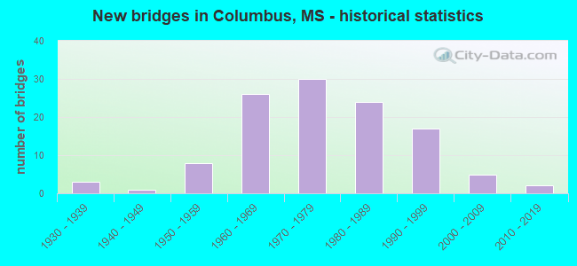
- New bridges - historical statistics
- 31930-1939
- 11940-1949
- 81950-1959
- 261960-1969
- 301970-1979
- 241980-1989
- 171990-1999
- 52000-2009
- 22010-2019


- Bridge Condition - Deck
- 1.3%Excellent
- 12.8%Very good
- 46.2%Good
- 33.3%Satisfactory
- 5.1%Fair
- 1.3%Poor

- Bridge Condition - Superstructure
- 1.3%Excellent
- 55.1%Very good
- 33.3%Good
- 7.7%Satisfactory
- 2.6%Fair

- Bridge Condition - Substructure
- 24.4%Very good
- 61.5%Good
- 11.5%Satisfactory
- 1.3%Fair
- 1.3%Serious

- Bridge Condition - Channel
- 10.1%Excellent
- 31.6%Very good
- 30.4%Good
- 24.1%Satisfactory
- 3.8%Fair

- Bridge Condition - Culverts
- 45.5%Very good
- 54.5%Good
Find on map >> Show street view
Structure Number: SA4400000000094, Location: SEC 16 T18S R18W (Lat: 33.514167, Lng: -88.427778), Route carried "on" structure: County highway 1070, Year Built: 1976, Status: Open, Structure Length: 1.10m (3.61ft), Average Daily Traffic: 8,830 (year 2021), Truck Traffic: 8%, Average Future Daily Traffic: 13,245 (year 2043), Design Load: HS 20, Features Intersected: MOORES CREEK, Facility Carried by Structure: 18TH AVE
Minimum Vertical Clearance: 30+ m (98+ ft), Kilometerpoint: 0.965, Lanes on structure: 2, Owner: City or Municipal Highway Agency, Approaching Roadway Width: 24.4m (80.1ft), Material/Design: Concrete, Design/Construction: Culvert, Number Of Spans In Main Unit: 2, Length of Maximum Span: 5.5m (18.0ft), Curb-To-Curb Width: 30.1m (98.8ft), Out-to-Out Width: 30.4m (99.7ft)
Condition: Channel: Very good, Culverts: Very good, Operating Rating: 61.8 metric tons, Method Used To Determine Operating Rating: Load Factor (LF), Inventory Rating: 36.9 metric tons, Method Used To Determine Inventory Rating: Load Factor (LF), Structural Evaluation: Equal to present desirable criteria, Deck Geometry: Superior to present desirable criteria, Waterway Adequacy: Equal to present desirable criteria, Approach Roadway Alignment: Equal to present desirable criteria, Designated Inspection Frequency: Every 24 months, Inspection Date: January 2020
Find on map >> Show street view
Structure Number: SA4400000000095, Location: SEC 17 T18S R18W (Lat: 33.506111, Lng: -88.437222), Route carried "on" structure: City street 137, Year Built: 2001, Status: Open, Structure Length: 2.83m (9.28ft), Average Daily Traffic: 400 (year 2017), Truck Traffic: 8%, Average Future Daily Traffic: 600 (year 2043), Design Load: HS 20, Features Intersected: CREEK, Facility Carried by Structure: COMMUNITY ROAD
Minimum Vertical Clearance: 30+ m (98+ ft), Kilometerpoint: 0.160, Lanes on structure: 2, Owner: City or Municipal Highway Agency, Approaching Roadway Width: 6.7m (22.0ft), Material/Design: Concrete, Design/Construction: Channel Beam, Number Of Spans In Main Unit: 3, Length of Maximum Span: 9.4m (30.8ft), Curb-To-Curb Width: 8.5m (27.9ft), Out-to-Out Width: 9.4m (30.8ft)
Condition: Deck: Very good, Superstructure: Very good, Substructure: Very good, Channel: Fair, Operating Rating: 63.1 metric tons, Method Used To Determine Operating Rating: Load Factor (LF), Inventory Rating: 37.9 metric tons, Method Used To Determine Inventory Rating: Load Factor (LF), Structural Evaluation: Equal to present desirable criteria, Deck Geometry: Equal to present minimum criteria, Waterway Adequacy: Equal to present minimum criteria, Approach Roadway Alignment: Better than present minimum criteria, Designated Inspection Frequency: Every 24 months, Inspection Date: April 2020, Deck Structure Type: Concrete Precast Panels, Wearing Surface/Protective System: Wearing Surface: Bituminous
Find on map >> Show street view
Structure Number: SA4400000000097, Location: SEC 22 T18S R18W (Lat: 33.492500, Lng: -88.400278), Route carried "on" structure: County highway 940, Year Built: 1974, Status: Open, Structure Length: 13.41m (44.00ft), Average Daily Traffic: 4,000 (year 2018), Truck Traffic: 8%, Average Future Daily Traffic: 6,000 (year 2038), Design Load: HS 15, Features Intersected: LUXAPALILA RIVER, Facility Carried by Structure: BELL AVENUE
Minimum Vertical Clearance: 30+ m (98+ ft), Kilometerpoint: 1.448, Lanes on structure: 2, Owner: City or Municipal Highway Agency, Approaching Roadway Width: 8.2m (26.9ft), Material/Design: Prestressed concrete, Design/Construction: Stringer/Multi-beam, Number Of Spans In Main Unit: 8, Length of Maximum Span: 24.4m (80.1ft), Curb or Sidewalk Widths: Left: 1.2m (3.9ft), Right: 1.2m (3.9ft), Curb-To-Curb Width: 8.2m (26.9ft), Out-to-Out Width: 10.6m (34.8ft)
Condition: Deck: Very good, Superstructure: Good, Substructure: Good, Channel: Satisfactory, Operating Rating: 61.8 metric tons, Method Used To Determine Operating Rating: Load Factor (LF), Inventory Rating: 37.6 metric tons, Method Used To Determine Inventory Rating: Load Factor (LF), Structural Evaluation: Better than present minimum criteria, Deck Geometry: High priority of corrective action, Waterway Adequacy: Equal to present desirable criteria, Approach Roadway Alignment: Equal to present desirable criteria, Length Of Structure Improvement: 13.41m (44.00ft), Designated Inspection Frequency: Every 24 months, Underwater Inspection Frequency: Every 60 months, Inspection Date: May 2020, Underwater Inspection Date: September 2020, Bridge Improvement Cost: $542,000, Roadway Improvement Cost: $54,000, Total Project Cost: $813,000 ( Estimate for 2018), Deck Structure Type: Concrete Cast-file-Place, Wearing Surface/Protective System: Wearing Surface: Monolithic Concrete
Find on map >> Show street view
Structure Number: SA4400000000099, Location: SEC 27 T18S R18W (Lat: 33.477500, Lng: -88.403889), Route carried "on" structure: County highway 151, Year Built: 1973, Status: Open, Structure Length: 14.63m (48.00ft), Average Daily Traffic: 5,500 (year 2018), Truck Traffic: 8%, Average Future Daily Traffic: 8,250 (year 2038), Design Load: HS 15, Features Intersected: LUXAPALILIA CREEK, Facility Carried by Structure: PICKENSVILLE ROAD
Minimum Vertical Clearance: 30+ m (98+ ft), Kilometerpoint: 8.529, Lanes on structure: 2, Owner: County Highway Agency, Approaching Roadway Width: 7.3m (24.0ft), Material/Design: Prestressed concrete, Design/Construction: Stringer/Multi-beam, Number Of Spans In Main Unit: 9, Length of Maximum Span: 24.4m (80.1ft), Curb or Sidewalk Widths: Left: 0.4m (1.3ft), Right: 0.4m (1.3ft), Curb-To-Curb Width: 7.9m (25.9ft), Out-to-Out Width: 8.7m (28.5ft)
Condition: Deck: Good, Superstructure: Good, Substructure: Satisfactory, Channel: Good, Operating Rating: 51.0 metric tons, Method Used To Determine Operating Rating: Load Factor (LF), Inventory Rating: 28.1 metric tons, Method Used To Determine Inventory Rating: Load Factor (LF), Structural Evaluation: Equal to present minimum criteria, Deck Geometry: High priority of corrective action, Waterway Adequacy: Equal to present desirable criteria, Approach Roadway Alignment: Equal to present desirable criteria, Length Of Structure Improvement: 14.63m (48.00ft), Designated Inspection Frequency: Every 24 months, Underwater Inspection Frequency: Every 60 months, Inspection Date: May 2020, Underwater Inspection Date: September 2020, Bridge Improvement Cost: $58,000, Roadway Improvement Cost: $200,000, Total Project Cost: $309,000 ( Estimate for 2018), Deck Structure Type: Concrete Cast-file-Place, Wearing Surface/Protective System: Wearing Surface: Monolithic Concrete
Find on map >> Show street view
Structure Number: SA4400000000105, Location: SEC 21 T19N R17E B (Lat: 33.507222, Lng: -88.520833), Route carried "on" structure: County highway 188, Year Built: 1999, Status: Open, Structure Length: 0.79m (2.59ft), Average Daily Traffic: 500 (year 2021), Truck Traffic: 8%, Average Future Daily Traffic: 750 (year 2043), Design Load: HS 20, Features Intersected: OAK SLUSH CREEK, Facility Carried by Structure: OLD WEST POINT RD
Minimum Vertical Clearance: 30+ m (98+ ft), Kilometerpoint: 5.632, Lanes on structure: 2, Owner: County Highway Agency, Approaching Roadway Width: 7.9m (25.9ft), Skew: 3 degrees, Material/Design: Concrete, Design/Construction: Culvert, Number Of Spans In Main Unit: 2, Length of Maximum Span: 3.1m (10.2ft), Curb-To-Curb Width: 8.2m (26.9ft), Out-to-Out Width: 8.5m (27.9ft)
Condition: Channel: Excellent, Culverts: Very good, Operating Rating: 76.5 metric tons, Method Used To Determine Operating Rating: Load Factor (LF), Inventory Rating: 45.8 metric tons, Method Used To Determine Inventory Rating: Load Factor (LF), Structural Evaluation: Equal to present desirable criteria, Deck Geometry: Somewhat better than minimum adequacy, Waterway Adequacy: Equal to present desirable criteria, Approach Roadway Alignment: Equal to present desirable criteria, Designated Inspection Frequency: Every 24 months, Inspection Date: January 2020
Find on map >> Show street view
Structure Number: SA4400000000106, Location: SEC 22 T19N R17E B (Lat: 33.507222, Lng: -88.502778), Route carried "on" structure: County highway 188, Year Built: 1999, Status: Open, Structure Length: 0.67m (2.20ft), Average Daily Traffic: 500 (year 2021), Truck Traffic: 8%, Average Future Daily Traffic: 750 (year 2043), Design Load: HS 20, Features Intersected: OAK SLUSH CREEK, Facility Carried by Structure: OLD WEST POINT RD
Minimum Vertical Clearance: 30+ m (98+ ft), Kilometerpoint: 7.402, Lanes on structure: 2, Owner: County Highway Agency, Approaching Roadway Width: 7.9m (25.9ft), Skew: 1 degrees, Material/Design: Concrete, Design/Construction: Culvert, Number Of Spans In Main Unit: 2, Length of Maximum Span: 3.0m (9.8ft), Curb-To-Curb Width: 6.7m (22.0ft), Out-to-Out Width: 7.0m (23.0ft)
Condition: Channel: Excellent, Culverts: Very good, Operating Rating: 62.1 metric tons, Method Used To Determine Operating Rating: Load Factor (LF), Inventory Rating: 37.3 metric tons, Method Used To Determine Inventory Rating: Load Factor (LF), Structural Evaluation: Equal to present desirable criteria, Deck Geometry: Meets minimum limits, Waterway Adequacy: Equal to present desirable criteria, Approach Roadway Alignment: Equal to present desirable criteria, Designated Inspection Frequency: Every 24 months, Inspection Date: January 2020
Find on map >> Show street view
Structure Number: SA4400000000108, Location: SEC 23 T19N R17E B (Lat: 33.495000, Lng: -88.491667), Route carried "on" structure: County highway 1712, Year Built: 1987, Status: Open, Structure Length: 5.00m (16.40ft), Average Daily Traffic: 670 (year 2021), Truck Traffic: 8%, Average Future Daily Traffic: 1,005 (year 2043), Design Load: HS 20, Features Intersected: OAK SLUSH CREEK, Facility Carried by Structure: PLYMOUTH BLUFF RD.
Minimum Vertical Clearance: 30+ m (98+ ft), Kilometerpoint: 1.126, Lanes on structure: 2, Owner: County Highway Agency, Approaching Roadway Width: 8.5m (27.9ft), Material/Design: Prestressed concrete, Design/Construction: Stringer/Multi-beam, Number Of Spans In Main Unit: 5, Length of Maximum Span: 12.2m (40.0ft), Curb or Sidewalk Widths: Left: 0.5m (1.6ft), Right: 0.5m (1.6ft), Curb-To-Curb Width: 8.5m (27.9ft), Out-to-Out Width: 9.5m (31.2ft)
Condition: Deck: Good, Superstructure: Very good, Substructure: Very good, Channel: Very good, Operating Rating: 43.2 metric tons, Method Used To Determine Operating Rating: Load Factor (LF), Inventory Rating: 25.8 metric tons, Method Used To Determine Inventory Rating: Load Factor (LF), Structural Evaluation: Equal to present minimum criteria, Deck Geometry: Somewhat better than minimum adequacy, Waterway Adequacy: Equal to present desirable criteria, Approach Roadway Alignment: Equal to present desirable criteria, Designated Inspection Frequency: Every 24 months, Inspection Date: April 2020, Deck Structure Type: Concrete Cast-file-Place, Wearing Surface/Protective System: Wearing Surface: Monolithic Concrete
Find on map >> Show street view
Structure Number: SA4400000000109, Location: SEC 24 T19N R17E B (Lat: 33.492583, Lng: -88.473611), Route carried "on" structure: County highway 188, Year Built: 1955, Status: Posted for load, Structure Length: 6.10m (20.01ft), Average Daily Traffic: 150 (year 2021), Truck Traffic: 8%, Average Future Daily Traffic: 225 (year 2043), Design Load: H 15, Features Intersected: OAK SLUSH CREEK, Facility Carried by Structure: OLD WEST POINT RD
Minimum Vertical Clearance: 30+ m (98+ ft), Kilometerpoint: 10.782, Lanes on structure: 2, Owner: County Highway Agency, Approaching Roadway Width: 6.1m (20.0ft), Material/Design: Steel, Design/Construction: Stringer/Multi-beam, Number Of Spans In Main Unit: 6, Length of Maximum Span: 24.4m (80.1ft), Curb or Sidewalk Widths: Left: 0.4m (1.3ft), Right: 0.4m (1.3ft), Curb-To-Curb Width: 7.3m (24.0ft), Out-to-Out Width: 8.2m (26.9ft)
Condition: Deck: Satisfactory, Superstructure: Satisfactory, Substructure: Fair, Channel: Satisfactory, Operating Rating: 29.1 metric tons, Method Used To Determine Operating Rating: Load Factor (LF), Inventory Rating: 17.4 metric tons, Method Used To Determine Inventory Rating: Load Factor (LF), Structural Evaluation: Somewhat better than minimum adequacy, Deck Geometry: Somewhat better than minimum adequacy, Waterway Adequacy: Equal to present desirable criteria, Approach Roadway Alignment: Equal to present minimum criteria, Bridge Posting: Required (Relationship of Operating Rating to Maximum Legal Load: 20.0 - 29.9% below), Length Of Structure Improvement: 7.14m (23.43ft), Designated Inspection Frequency: Every 24 months, Inspection Date: December 2021, Bridge Improvement Cost: $633,000, Roadway Improvement Cost: $507,000, Total Project Cost: $1,140,000 ( Estimate for 2021), Deck Structure Type: Concrete Cast-file-Place, Wearing Surface/Protective System: Wearing Surface: Bituminous
Find on map >> Show street view
Structure Number: SA440000000011, Location: SEC 28 T19N R17E B (Lat: 33.483578, Lng: -88.532197), Route carried "on" structure: County highway 192, Year Built: 1985, Status: Open, Structure Length: 0.94m (3.08ft), Average Daily Traffic: 150 (year 2021), Truck Traffic: 8%, Average Future Daily Traffic: 225 (year 2043), Design Load: H 15, Features Intersected: MAYO CREEK, Facility Carried by Structure: TAYLOR THURSTON RD
Minimum Vertical Clearance: 30+ m (98+ ft), Kilometerpoint: 0.643, Lanes on structure: 2, Owner: County Highway Agency, Approaching Roadway Width: 7.3m (24.0ft), Material/Design: Concrete, Design/Construction: Channel Beam, Number Of Spans In Main Unit: 1, Length of Maximum Span: 9.4m (30.8ft), Curb or Sidewalk Widths: Left: 0.2m (0.7ft), Right: 0.2m (0.7ft), Curb-To-Curb Width: 8.1m (26.6ft), Out-to-Out Width: 8.5m (27.9ft)
Condition: Deck: Good, Superstructure: Good, Substructure: Good, Channel: Very good, Operating Rating: 53.9 metric tons, Method Used To Determine Operating Rating: Load Factor (LF), Inventory Rating: 32.4 metric tons, Method Used To Determine Inventory Rating: Load Factor (LF), Structural Evaluation: Better than present minimum criteria, Deck Geometry: Somewhat better than minimum adequacy, Waterway Adequacy: Equal to present desirable criteria, Approach Roadway Alignment: Better than present minimum criteria, Length Of Structure Improvement: 0.94m (3.08ft), Designated Inspection Frequency: Every 24 months, Inspection Date: March 2020, Bridge Improvement Cost: $8,000, Roadway Improvement Cost: $12,000, Total Project Cost: $225,000 ( Estimate for 2017), Deck Structure Type: Concrete Precast Panels, Wearing Surface/Protective System: Wearing Surface: Monolithic Concrete
Find on map >> Show street view
Structure Number: SA4400000000123, Location: SEC 23 T17S R18W B (Lat: 33.566389, Lng: -88.391389), Route carried "on" structure: County highway 761, Year Built: 1997, Status: Open, Structure Length: 1.74m (5.71ft), Average Daily Traffic: 1,200 (year 2021), Truck Traffic: 8%, Average Future Daily Traffic: 1,800 (year 2043), Design Load: HS 20, Features Intersected: RELEIF, Facility Carried by Structure: JESS LYONS ROAD
Minimum Vertical Clearance: 30+ m (98+ ft), Kilometerpoint: 2.671, Lanes on structure: 2, Owner: County Highway Agency, Approaching Roadway Width: 8.5m (27.9ft), Material/Design: Prestressed concrete, Design/Construction: Stringer/Multi-beam, Number Of Spans In Main Unit: 3, Length of Maximum Span: 5.8m (19.0ft), Curb or Sidewalk Widths: Left: 0.5m (1.6ft), Right: 0.5m (1.6ft), Curb-To-Curb Width: 8.5m (27.9ft), Out-to-Out Width: 9.5m (31.2ft)
Condition: Deck: Very good, Superstructure: Very good, Substructure: Very good, Channel: Excellent, Operating Rating: 90.8 metric tons, Method Used To Determine Operating Rating: Load Factor (LF), Inventory Rating: 37.9 metric tons, Method Used To Determine Inventory Rating: Load Factor (LF), Structural Evaluation: Equal to present desirable criteria, Deck Geometry: Somewhat better than minimum adequacy, Waterway Adequacy: Equal to present desirable criteria, Approach Roadway Alignment: Equal to present desirable criteria, Designated Inspection Frequency: Every 24 months, Inspection Date: March 2020, Deck Structure Type: Concrete Cast-file-Place, Wearing Surface/Protective System: Wearing Surface: Monolithic Concrete
Find on map >> Show street view
Structure Number: SA4400000000128, Location: SEC 16 T18S R18W (Lat: 33.501111, Lng: -88.432222), Route carried "on" structure: City street 357, Year Built: 2001, Status: Open, Structure Length: 1.17m (3.84ft), Average Daily Traffic: 50 (year 2021), Truck Traffic: 8%, Average Future Daily Traffic: 75 (year 2043), Design Load: HS 20, Features Intersected: MOORES CREEK, Facility Carried by Structure: SEVENTH AVE NORTH
Minimum Vertical Clearance: 30+ m (98+ ft), Kilometerpoint: 0.360, Lanes on structure: 2, Owner: City or Municipal Highway Agency, Approaching Roadway Width: 8.5m (27.9ft), Material/Design: Concrete, Design/Construction: Culvert, Number Of Spans In Main Unit: 2, Length of Maximum Span: 5.5m (18.0ft), Curb-To-Curb Width: 11.9m (39.0ft), Out-to-Out Width: 12.2m (40.0ft)
Condition: Channel: Fair, Culverts: Very good, Operating Rating: 87.6 metric tons, Method Used To Determine Operating Rating: Load Factor (LF), Inventory Rating: 52.3 metric tons, Method Used To Determine Inventory Rating: Load Factor (LF), Structural Evaluation: Equal to present desirable criteria, Deck Geometry: Superior to present desirable criteria, Waterway Adequacy: Better than present minimum criteria, Approach Roadway Alignment: Equal to present desirable criteria, Designated Inspection Frequency: Every 24 months, Inspection Date: January 2020
Find on map >> Show street view
Structure Number: SA4400000000129, Location: SEC 21 T19N R17E B (Lat: 33.507222, Lng: -88.530278), Route carried "on" structure: County highway 188, Year Built: 1999, Status: Open, Structure Length: 0.61m (2.00ft), Average Daily Traffic: 500 (year 2021), Truck Traffic: 8%, Average Future Daily Traffic: 750 (year 2043), Design Load: HS 20, Features Intersected: BCH OF OLD SLUSH CREEK, Facility Carried by Structure: OLD WEST POINT RD
Minimum Vertical Clearance: 30+ m (98+ ft), Kilometerpoint: 2.990, Lanes on structure: 2, Owner: County Highway Agency, Approaching Roadway Width: 7.9m (25.9ft), Material/Design: Concrete, Design/Construction: Culvert, Number Of Spans In Main Unit: 2, Length of Maximum Span: 3.1m (10.2ft), Curb-To-Curb Width: 8.2m (26.9ft), Out-to-Out Width: 8.3m (27.2ft)
Condition: Channel: Excellent, Culverts: Very good, Operating Rating: 81.7 metric tons, Method Used To Determine Operating Rating: Load Factor (LF), Inventory Rating: 49.0 metric tons, Method Used To Determine Inventory Rating: Load Factor (LF), Structural Evaluation: Equal to present desirable criteria, Deck Geometry: Somewhat better than minimum adequacy, Waterway Adequacy: Equal to present desirable criteria, Approach Roadway Alignment: Equal to present desirable criteria, Designated Inspection Frequency: Every 24 months, Inspection Date: January 2020
Find on map >> Show street view
Structure Number: SA440000000013, Location: SEC 25 T17S R18W (Lat: 33.559722, Lng: -88.369444), Route carried "on" structure: County highway 12, Year Built: 1949, Status: Open, Structure Length: 0.79m (2.59ft), Average Daily Traffic: 4,800 (year 2021), Truck Traffic: 8%, Average Future Daily Traffic: 7,200 (year 2043), Design Load: HS 20+Mod, Features Intersected: DRY CREEK
Minimum Vertical Clearance: 30+ m (98+ ft), Kilometerpoint: 4.828, Lanes on structure: 2, Owner: County Highway Agency, Approaching Roadway Width: 7.3m (24.0ft), Material/Design: Concrete, Design/Construction: Culvert, Number Of Spans In Main Unit: 2, Length of Maximum Span: 3.7m (12.1ft), Curb-To-Curb Width: 8.0m (26.2ft), Out-to-Out Width: 9.1m (29.9ft)
Condition: Channel: Good, Culverts: Good, Operating Rating: 54.6 metric tons, Method Used To Determine Operating Rating: Load Factor (LF), Inventory Rating: 32.7 metric tons, Method Used To Determine Inventory Rating: Load Factor (LF), Structural Evaluation: Better than present minimum criteria, Deck Geometry: High priority of corrective action, Waterway Adequacy: Better than present minimum criteria, Approach Roadway Alignment: Equal to present desirable criteria, Length Of Structure Improvement: 1.74m (5.71ft), Designated Inspection Frequency: Every 24 months, Inspection Date: Febuary 2020, Bridge Improvement Cost: $55,000, Roadway Improvement Cost: $20,000, Total Project Cost: $290,000 ( Estimate for 2017)
Find on map >> Show street view
Structure Number: SA4400000000131, Location: SEC 36 T17S R18W (Lat: 33.551389, Lng: -88.381944), Route carried "on" structure: County highway 12, Year Built: 1988, Status: Open, Structure Length: 4.63m (15.19ft), Average Daily Traffic: 5,800 (year 2021), Truck Traffic: 8%, Average Future Daily Traffic: 8,700 (year 2043), Design Load: HS 20, Features Intersected: BLACK CREEK
Minimum Vertical Clearance: 30+ m (98+ ft), Kilometerpoint: 3.380, Lanes on structure: 2, Owner: County Highway Agency, Approaching Roadway Width: 7.3m (24.0ft), Material/Design: Prestressed concrete, Design/Construction: Stringer/Multi-beam, Number Of Spans In Main Unit: 3, Length of Maximum Span: 15.2m (49.9ft), Curb or Sidewalk Widths: Left: 0.5m (1.6ft), Right: 0.5m (1.6ft), Curb-To-Curb Width: 12.0m (39.4ft), Out-to-Out Width: 13.0m (42.7ft)
Condition: Deck: Very good, Superstructure: Very good, Substructure: Very good, Channel: Very good, Operating Rating: 65.0 metric tons, Method Used To Determine Operating Rating: Load Factor (LF), Inventory Rating: 37.9 metric tons, Method Used To Determine Inventory Rating: Load Factor (LF), Structural Evaluation: Equal to present desirable criteria, Deck Geometry: Somewhat better than minimum adequacy, Waterway Adequacy: Equal to present desirable criteria, Approach Roadway Alignment: Equal to present desirable criteria, Designated Inspection Frequency: Every 24 months, Inspection Date: March 2020, Deck Structure Type: Concrete Cast-file-Place, Wearing Surface/Protective System: Wearing Surface: Monolithic Concrete
Find on map >> Show street view
Structure Number: SA4400000000133, Location: SEC 12 T18S R17W B (Lat: 33.517222, Lng: -88.374167), Route carried "on" structure: County highway 9999, Year Built: 2000, Status: Open, Structure Length: 34.75m (114.01ft), Average Daily Traffic: 1,500 (year 2018), Truck Traffic: 8%, Average Future Daily Traffic: 2,250 (year 2038), Design Load: HS 20, Features Intersected: MAGBY CREEK, Facility Carried by Structure: PLANTATION POINTE
Minimum Vertical Clearance: 30+ m (98+ ft), Kilometerpoint: 0.100, Lanes on structure: 2, Owner: County Highway Agency, Approaching Roadway Width: 11.0m (36.1ft), Material/Design: Concrete, Design/Construction: Channel Beam, Number Of Spans In Main Unit: 25, Length of Maximum Span: 18.3m (60.0ft), Curb-To-Curb Width: 11.0m (36.1ft), Out-to-Out Width: 11.7m (38.4ft)
Condition: Deck: Very good, Superstructure: Very good, Substructure: Very good, Channel: Very good, Operating Rating: 67.0 metric tons, Method Used To Determine Operating Rating: Load Factor (LF), Inventory Rating: 35.6 metric tons, Method Used To Determine Inventory Rating: Load Factor (LF), Structural Evaluation: Equal to present desirable criteria, Deck Geometry: Equal to present minimum criteria, Waterway Adequacy: Superior to present desirable criteria, Approach Roadway Alignment: Equal to present desirable criteria, Designated Inspection Frequency: Every 24 months, Inspection Date: January 2021, Deck Structure Type: Concrete Precast Panels, Wearing Surface/Protective System: Wearing Surface: Monolithic Concrete
Find on map >> Show street view
Structure Number: SA4400000000136, Location: SEC 11 T18S R18W (Lat: 33.507500, Lng: -88.389722), Route carried "on" structure: Business City street 50, Year Built: 1964, Status: Open, Structure Length: 3.66m (12.01ft), Average Daily Traffic: 9,000 (year 2021), Truck Traffic: 10%, Average Future Daily Traffic: 12,000 (year 2043), Design Load: H 20, Features Intersected: MAGBY CREEK, Facility Carried by Structure: GARDNER
Minimum Vertical Clearance: 30+ m (98+ ft), Kilometerpoint: 152.000, Lanes on structure: 2, Owner: City or Municipal Highway Agency, Approaching Roadway Width: 9.8m (32.2ft), Material/Design: Prestressed concrete, Design/Construction: Stringer/Multi-beam, Number Of Spans In Main Unit: 3, Length of Maximum Span: 12.2m (40.0ft), Curb-To-Curb Width: 7.9m (25.9ft), Out-to-Out Width: 8.8m (28.9ft)
Condition: Deck: Good, Superstructure: Good, Substructure: Good, Channel: Good, Operating Rating: 55.7 metric tons, Method Used To Determine Operating Rating: Load Factor (LF) rating reported by rating factor (RF) method using MS18 loading, Inventory Rating: 19.4 metric tons, Method Used To Determine Inventory Rating: Load Factor (LF) rating reported by rating factor (RF) method using MS18 loading, Structural Evaluation: Meets minimum limits, Deck Geometry: High priority of replacement, Waterway Adequacy: Better than present minimum criteria, Approach Roadway Alignment: Equal to present desirable criteria, Length Of Structure Improvement: 3.66m (12.01ft), Designated Inspection Frequency: Every 24 months, Inspection Date: Febuary 2020, Bridge Improvement Cost: $130,000, Roadway Improvement Cost: $130,000, Total Project Cost: $301,000, Deck Structure Type: Concrete Cast-file-Place, Wearing Surface/Protective System: Wearing Surface: Bituminous
Find on map >> Show street view
Structure Number: SA4400000000139, Location: SEC 32 T17S R18W (Lat: 33.541389, Lng: -88.438333), Route carried "on" structure: City street , Year Built: 2006, Status: Open, Structure Length: 1.16m (3.81ft), Average Daily Traffic: 200 (year 2021), Truck Traffic: 8%, Average Future Daily Traffic: 300 (year 2043), Design Load: HS 20, Features Intersected: CREEK, Facility Carried by Structure: NEWBELL ROAD
Minimum Vertical Clearance: 30+ m (98+ ft), Kilometerpoint: 3.702, Lanes on structure: 2, Owner: City or Municipal Highway Agency, Approaching Roadway Width: 8.5m (27.9ft), Material/Design: Concrete, Design/Construction: Channel Beam, Number Of Spans In Main Unit: 2, Length of Maximum Span: 5.8m (19.0ft), Curb-To-Curb Width: 8.2m (26.9ft), Out-to-Out Width: 8.5m (27.9ft)
Condition: Deck: Good, Superstructure: Good, Substructure: Good, Channel: Good, Operating Rating: 60.1 metric tons, Method Used To Determine Operating Rating: Load Factor (LF), Inventory Rating: 36.0 metric tons, Method Used To Determine Inventory Rating: Load Factor (LF), Structural Evaluation: Better than present minimum criteria, Deck Geometry: Somewhat better than minimum adequacy, Waterway Adequacy: Better than present minimum criteria, Approach Roadway Alignment: Equal to present desirable criteria, Designated Inspection Frequency: Every 24 months, Inspection Date: April 2020, Deck Structure Type: Concrete Precast Panels, Wearing Surface/Protective System: Wearing Surface: Gravel
Find on map >> Show street view
Structure Number: 21000450441590A, Location: US 45 SOUTH OVER US 82 (Lat: 33.483831, Lng: -88.490600), Route carried "under" structure: US 82, Year Built: 1967, Structure Length: 0. m, Average Daily Traffic: 13,000 (year 2017), Truck Traffic: 8%, Features Intersected: US 82, Facility Carried by Structure: US 45
Minimum Vertical Clearance: 5.09m (16.70ft), Kilometerpoint: 22.270, Lanes on structure: 2, Lanes under structure: 4, Material/Design: Prestressed concrete, Design/Construction: Stringer/Multi-beam, Length of Maximum Span: 18.3m (60.0ft)
Find on map >> Show street view
Structure Number: 21000450441590A, Location: US 45 SOUTH OVER US 82 (Lat: 33.483669, Lng: -88.490511), Route carried "under" structure: US 82, Year Built: 1967, Structure Length: 0. m, Average Daily Traffic: 13,000 (year 2017), Truck Traffic: 8%, Features Intersected: US 82, Facility Carried by Structure: US 45
Minimum Vertical Clearance: 4.97m (16.31ft), Kilometerpoint: 17.125, Lanes on structure: 2, Lanes under structure: 4, Material/Design: Prestressed concrete, Design/Construction: Stringer/Multi-beam, Length of Maximum Span: 18.3m (60.0ft)
Find on map >> Show street view
Structure Number: 21000450441590B, Location: US 45 SOUTH OVER US 82 (Lat: 33.483900, Lng: -88.490411), Route carried "under" structure: US 82, Year Built: 1967, Structure Length: 0. m, Average Daily Traffic: 9,500 (year 2017), Truck Traffic: 8%, Features Intersected: US 82, Facility Carried by Structure: US 45
Minimum Vertical Clearance: 5.18m (16.99ft), Kilometerpoint: 22.251, Lanes on structure: 2, Lanes under structure: 4, Material/Design: Prestressed concrete, Design/Construction: Stringer/Multi-beam, Length of Maximum Span: 18.3m (60.0ft)
Find on map >> Show street view
Structure Number: 21000450441590B, Location: US 45 SOUTH OVER US 82 (Lat: 33.483739, Lng: -88.490319), Route carried "under" structure: US 82, Year Built: 1967, Structure Length: 0. m, Average Daily Traffic: 9,500 (year 2017), Truck Traffic: 8%, Features Intersected: US 82, Facility Carried by Structure: US 45
Minimum Vertical Clearance: 5.06m (16.60ft), Kilometerpoint: 17.144, Lanes on structure: 2, Lanes under structure: 4, Material/Design: Prestressed concrete, Design/Construction: Stringer/Multi-beam, Length of Maximum Span: 18.3m (60.0ft)
Find on map >> Show street view
Structure Number: 21000820441717A, Location: SR 69 OVER US 45/US 82 (Lat: 33.499911, Lng: -88.438881), Route carried "under" structure: US 82, Year Built: 1967, Structure Length: 0. m, Average Daily Traffic: 9,500 (year 2017), Truck Traffic: 8%, Features Intersected: US 45/US 82, Facility Carried by Structure: SR 69
Minimum Vertical Clearance: 5.03m (16.50ft), Kilometerpoint: 17.024, Lanes on structure: 2, Lanes under structure: 2, Material/Design: Prestressed concrete, Design/Construction: Stringer/Multi-beam, Length of Maximum Span: 18.3m (60.0ft)
Find on map >> Show street view
Structure Number: 21000820441717A, Location: SR 69 OVER US 45/US 82 (Lat: 33.499781, Lng: -88.438739), Route carried "under" structure: US 82, Year Built: 1967, Structure Length: 0. m, Average Daily Traffic: 9,500 (year 2017), Truck Traffic: 8%, Features Intersected: US 45/US 82, Facility Carried by Structure: SR 69
Minimum Vertical Clearance: 5.03m (16.50ft), Kilometerpoint: 22.376, Lanes on structure: 2, Lanes under structure: 2, Material/Design: Prestressed concrete, Design/Construction: Stringer/Multi-beam, Length of Maximum Span: 18.3m (60.0ft)
Find on map >> Show street view
Structure Number: 21000820441717B, Location: SR 69 OVER US 45/US 82 (Lat: 33.500019, Lng: -88.438731), Route carried "under" structure: US 82, Year Built: 1967, Structure Length: 0. m, Average Daily Traffic: 9,500 (year 2017), Truck Traffic: 8%, Features Intersected: US 45/US 82, Facility Carried by Structure: SR 69
Minimum Vertical Clearance: 5.06m (16.60ft), Kilometerpoint: 17.004, Lanes on structure: 2, Lanes under structure: 2, Material/Design: Prestressed concrete, Design/Construction: Stringer/Multi-beam, Length of Maximum Span: 18.3m (60.0ft)
Find on map >> Show street view
Structure Number: 21000820441717B, Location: SR 69 OVER US 45/US 82 (Lat: 33.499889, Lng: -88.438581), Route carried "under" structure: US 82, Year Built: 1967, Structure Length: 0. m, Average Daily Traffic: 9,500 (year 2017), Truck Traffic: 8%, Features Intersected: US 45/US 82, Facility Carried by Structure: SR 69
Minimum Vertical Clearance: 5.03m (16.50ft), Kilometerpoint: 22.396, Lanes on structure: 2, Lanes under structure: 2, Material/Design: Prestressed concrete, Design/Construction: Stringer/Multi-beam, Length of Maximum Span: 18.3m (60.0ft)
Find on map >> Show street view
Structure Number: 21000820441729A, Location: US 82 OVER US 45 NORTH (Lat: 33.505711, Lng: -88.431881), Route carried "under" structure: US 45, Year Built: 1977, Structure Length: 0. m, Average Daily Traffic: 13,000 (year 2017), Truck Traffic: 8%, Features Intersected: US 45, Facility Carried by Structure: US 82
Minimum Vertical Clearance: 4.88m (16.01ft), Kilometerpoint: 7.936, Lanes on structure: 2, Lanes under structure: 4, Material/Design: Prestressed concrete, Design/Construction: Stringer/Multi-beam, Length of Maximum Span: 33.2m (108.9ft)
Find on map >> Show street view
Structure Number: 21000820441729A, Location: US 82 OVER US 45 NORTH (Lat: 33.505950, Lng: -88.431700), Route carried "under" structure: US 45, Year Built: 1977, Structure Length: 0. m, Average Daily Traffic: 13,000 (year 2017), Truck Traffic: 8%, Features Intersected: US 45, Facility Carried by Structure: US 82
Minimum Vertical Clearance: 5.00m (16.40ft), Kilometerpoint: 23.550, Lanes on structure: 2, Lanes under structure: 4, Material/Design: Prestressed concrete, Design/Construction: Stringer/Multi-beam, Length of Maximum Span: 33.2m (108.9ft)
Find on map >> Show street view
Structure Number: 21000820441729B, Location: US 82 OVER US 45 NORTH (Lat: 33.505511, Lng: -88.431789), Route carried "under" structure: US 45, Year Built: 1977, Structure Length: 0. m, Average Daily Traffic: 13,000 (year 2017), Truck Traffic: 8%, Features Intersected: US 45, Facility Carried by Structure: US 82
Minimum Vertical Clearance: 4.94m (16.21ft), Kilometerpoint: 7.958, Lanes on structure: 3, Lanes under structure: 5, Material/Design: Prestressed concrete, Design/Construction: Stringer/Multi-beam, Length of Maximum Span: 33.2m (108.9ft)
Find on map >> Show street view
Structure Number: 21000820441729B, Location: US 82 OVER US 45 NORTH (Lat: 33.505739, Lng: -88.431611), Route carried "under" structure: US 45, Year Built: 1977, Structure Length: 0. m, Average Daily Traffic: 13,000 (year 2017), Truck Traffic: 8%, Features Intersected: US 45, Facility Carried by Structure: US 82
Minimum Vertical Clearance: 5.15m (16.90ft), Kilometerpoint: 23.525, Lanes on structure: 3, Lanes under structure: 5, Material/Design: Prestressed concrete, Design/Construction: Stringer/Multi-beam, Length of Maximum Span: 33.2m (108.9ft)
Find on map >> Show street view
Structure Number: 21000820441769, Location: US 82 OVER SR 50/SR12 (Lat: 33.518919, Lng: -88.373850), Route carried "under" structure: State highway 50, Year Built: 1989, Structure Length: 0. m, Average Daily Traffic: 10,000 (year 2017), Truck Traffic: 8%, Features Intersected: SR 50, Facility Carried by Structure: US 82
Minimum Vertical Clearance: 4.91m (16.11ft), Kilometerpoint: 0.671, Lanes on structure: 4, Lanes under structure: 5, Material/Design: Prestressed concrete, Design/Construction: Stringer/Multi-beam, Length of Maximum Span: 33.8m (110.9ft)
Find on map >> Show street view
Structure Number: 21000820441769, Location: US 82 OVER SR 50/SR12 (Lat: 33.518731, Lng: -88.373611), Route carried "under" structure: State highway 50, Year Built: 1989, Structure Length: 0. m, Average Daily Traffic: 10,000 (year 2017), Truck Traffic: 8%, Features Intersected: SR 50, Facility Carried by Structure: US 82
Minimum Vertical Clearance: 5.09m (16.70ft), Kilometerpoint: 0.566, Lanes on structure: 4, Lanes under structure: 5, Material/Design: Prestressed concrete, Design/Construction: Stringer/Multi-beam, Length of Maximum Span: 33.8m (110.9ft)
Find on map >> Show street view
Structure Number: 41000450441603, Location: 1.3 MI E JCT US 45S/US 82 (Lat: 33.489681, Lng: -88.470439), Route carried "under" structure: US 82, Year Built: 1967, Structure Length: 0. m, Average Daily Traffic: 15,000 (year 2017), Truck Traffic: 8%, Features Intersected: US 45/US 82, Facility Carried by Structure: WEST POINT ROAD
Minimum Vertical Clearance: 4.97m (16.31ft), Kilometerpoint: 20.283, Lanes on structure: 2, Lanes under structure: 4, Material/Design: Prestressed concrete, Design/Construction: Stringer/Multi-beam, Length of Maximum Span: 18.3m (60.0ft)
Find on map >> Show street view
Structure Number: 41000450441603, Location: 1.3 MI E JCT US 45S/US 82 (Lat: 33.489500, Lng: -88.470389), Route carried "under" structure: US 82, Year Built: 1967, Structure Length: 0. m, Average Daily Traffic: 15,000 (year 2017), Truck Traffic: 8%, Features Intersected: US 45/US 82, Facility Carried by Structure: WEST POINT ROAD
Minimum Vertical Clearance: 4.91m (16.11ft), Kilometerpoint: 19.108, Lanes on structure: 2, Lanes under structure: 4, Material/Design: Prestressed concrete, Design/Construction: Stringer/Multi-beam, Length of Maximum Span: 18.3m (60.0ft)