Bridge Statistics for Concord, North Carolina (NC)
Condition, Traffic, Stress, Structural Evaluation, Project Costs
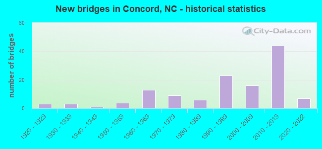
- New bridges - historical statistics
- 31920-1929
- 31930-1939
- 11940-1949
- 41950-1959
- 131960-1969
- 91970-1979
- 61980-1989
- 231990-1999
- 162000-2009
- 442010-2019
- 72020-2022

- Reconstructed bridges - Historical Statistics
- 31940-1949
- 11950-1959
- 01960-1969
- 01970-1979
- 21980-1989
- 21990-1999
- 02000-2009
- 12010-2019


- Bridge Condition - Deck
- 1.4%Excellent
- 16.4%Very good
- 52.1%Good
- 19.2%Satisfactory
- 8.2%Fair
- 2.7%Poor

- Bridge Condition - Superstructure
- 4.1%Excellent
- 46.6%Very good
- 23.3%Good
- 11.0%Satisfactory
- 12.3%Fair
- 2.7%Poor

- Bridge Condition - Substructure
- 4.1%Excellent
- 24.7%Very good
- 39.7%Good
- 15.1%Satisfactory
- 12.3%Fair
- 4.1%Poor

- Bridge Condition - Channel
- 1.4%Excellent
- 2.8%Very good
- 51.4%Good
- 23.6%Satisfactory
- 20.8%Fair

- Bridge Condition - Culverts
- 4.0%Excellent
- 16.0%Good
- 48.0%Satisfactory
- 24.0%Fair
- 8.0%Poor
Find on map >> Show street view
Structure Number: 250384, Location: 0.4 MI. W. JCT. SR1430 (Lat: 35.413878, Lng: -80.674164), Route carried "on" structure: City street , Year Built: 2004, Status: Open, Structure Length: 1.37m (4.49ft), Average Daily Traffic: 1,500 (year 2004), Truck Traffic: 7%, Average Future Daily Traffic: 3,000 (year 2040), Design Load: HS 20+Mod, Features Intersected: AFTON RUN BRANCH, Facility Carried by Structure: VILLAGE DRIVE
Minimum Vertical Clearance: 30+ m (98+ ft), Kilometerpoint: 0.000, Lanes on structure: 2, Owner: City or Municipal Highway Agency, Approaching Roadway Width: 7.6m (24.9ft), Material/Design: Concrete, Design/Construction: Culvert, Number Of Spans In Main Unit: 1, Length of Maximum Span: 13.7m (44.9ft)
Condition: Channel: Satisfactory, Culverts: Good, Operating Rating: 89.8 metric tons, Method Used To Determine Operating Rating: Load and Resistance Factor (LRFR), Inventory Rating: 89.8 metric tons, Method Used To Determine Inventory Rating: Load and Resistance Factor (LRFR), Structural Evaluation: Better than present minimum criteria, Waterway Adequacy: Better than present minimum criteria, Approach Roadway Alignment: Equal to present desirable criteria, Designated Inspection Frequency: Every 24 months, Inspection Date: June 2020
Find on map >> Show street view
Structure Number: 250385, Location: 0.1MI.E.JCT.CENTRAL AVE. (Lat: 35.411453, Lng: -80.603564), Route carried "on" structure: City street , Year Built: 2008, Status: Open, Structure Length: 0.64m (2.10ft), Average Daily Traffic: 1,000 (year 2008), Truck Traffic: 7%, Average Future Daily Traffic: 2,000 (year 2040), Design Load: HS 20+Mod, Features Intersected: BR.IRISH BUFFALO CREEK, Facility Carried by Structure: MISENHEIMER DRIVE
Minimum Vertical Clearance: 30+ m (98+ ft), Kilometerpoint: 0.000, Lanes on structure: 2, Owner: City or Municipal Highway Agency, Approaching Roadway Width: 7.6m (24.9ft), Skew: 1 degrees, Material/Design: Concrete, Design/Construction: Culvert, Number Of Spans In Main Unit: 1, Length of Maximum Span: 6.0m (19.7ft)
Condition: Channel: Satisfactory, Culverts: Satisfactory, Operating Rating: 41.7 metric tons, Method Used To Determine Operating Rating: Field evaluation and documented engineering judgment, Inventory Rating: 32.6 metric tons, Method Used To Determine Inventory Rating: Field evaluation and documented engineering judgment, Structural Evaluation: Equal to present minimum criteria, Waterway Adequacy: Better than present minimum criteria, Approach Roadway Alignment: Equal to present desirable criteria, Designated Inspection Frequency: Every 24 months, Inspection Date: June 2020
Find on map >> Show street view
Structure Number: 250386, Location: 0.55 MI. E. JCT. US29 (Lat: 35.345314, Lng: -80.683022), Route carried "on" structure: State highway 1300, Year Built: 2011, Status: Open, Structure Length: 1.34m (4.40ft), Average Daily Traffic: 13,500 (year 2018), Truck Traffic: 6%, Average Future Daily Traffic: 27,000 (year 2040), Design Load: HL 93, Features Intersected: TRAMWAY
Minimum Vertical Clearance: 30+ m (98+ ft), Kilometerpoint: 0.000, Lanes on structure: 4, Lanes under structure: 2, Owner: State Highway Agency, Approaching Roadway Width: 17.3m (56.8ft), Material/Design: Prestressed concrete, Design/Construction: Slab, Number Of Spans In Main Unit: 1, Length of Maximum Span: 13.1m (43.0ft), Curb or Sidewalk Widths: Left: 2.1m (6.9ft), Right: 2.1m (6.9ft), Curb-To-Curb Width: 19.5m (64.0ft), Out-to-Out Width: 24.6m (80.7ft)
Condition: Deck: Good, Superstructure: Good, Substructure: Good, Operating Rating: 70.7 metric tons, Method Used To Determine Operating Rating: Load and Resistance Factor (LRFR), Inventory Rating: 54.4 metric tons, Method Used To Determine Inventory Rating: Load and Resistance Factor (LRFR), Structural Evaluation: Better than present minimum criteria, Deck Geometry: High priority of corrective action, Underclear: Somewhat better than minimum adequacy, Approach Roadway Alignment: Equal to present desirable criteria, Designated Inspection Frequency: Every 24 months, Inspection Date: June 2021, Deck Structure Type: Concrete Precast Panels, Wearing Surface/Protective System: Wearing Surface: Bituminous
Find on map >> Show street view
Structure Number: 250387, Location: .2MI.N.JCT.SR2894 (Lat: 35.375736, Lng: -80.722506), Route carried "on" structure: City street , Year Built: 2008, Status: Open, Structure Length: 1.12m (3.67ft), Average Daily Traffic: 500 (year 2008), Average Future Daily Traffic: 1,000 (year 2040), Design Load: HS 20+Mod, Features Intersected: UT TO ROCKY RIVER, Facility Carried by Structure: THUNDER ROAD
Minimum Vertical Clearance: 30+ m (98+ ft), Kilometerpoint: 0.000, Lanes on structure: 3, Owner: City or Municipal Highway Agency, Approaching Roadway Width: 12.1m (39.7ft), Material/Design: Concrete continuous, Design/Construction: Culvert, Number Of Spans In Main Unit: 4, Length of Maximum Span: 2.4m (7.9ft)
Condition: Channel: Fair, Culverts: Satisfactory, Operating Rating: 41.7 metric tons, Method Used To Determine Operating Rating: Field evaluation and documented engineering judgment, Inventory Rating: 32.6 metric tons, Method Used To Determine Inventory Rating: Field evaluation and documented engineering judgment, Structural Evaluation: Equal to present minimum criteria, Waterway Adequacy: Better than present minimum criteria, Approach Roadway Alignment: Equal to present desirable criteria, Designated Inspection Frequency: Every 24 months, Inspection Date: June 2020
Find on map >> Show street view
Structure Number: 250388, Location: 0.1 MI. E. JCT. ROUSH PLA (Lat: 35.383056, Lng: -80.716056), Route carried "on" structure: City street , Year Built: 2008, Status: Open, Structure Length: 0.70m (2.30ft), Average Daily Traffic: 750 (year 2015), Truck Traffic: 7%, Average Future Daily Traffic: 5,000 (year 2040), Design Load: HS 20+Mod, Features Intersected: UT TO ROCKY RIVER, Facility Carried by Structure: ZEPHYR PLACE
Minimum Vertical Clearance: 30+ m (98+ ft), Kilometerpoint: 0.000, Lanes on structure: 2, Owner: City or Municipal Highway Agency, Approaching Roadway Width: 9.7m (31.8ft), Material/Design: Steel, Design/Construction: Culvert, Length of Maximum Span: 3.0m (9.8ft)
Condition: Channel: Satisfactory, Culverts: Poor, Operating Rating: 78.0 metric tons, Method Used To Determine Operating Rating: Load and Resistance Factor (LRFR), Inventory Rating: 59.8 metric tons, Method Used To Determine Inventory Rating: Load and Resistance Factor (LRFR), Structural Evaluation: Meets minimum limits, Waterway Adequacy: Better than present minimum criteria, Approach Roadway Alignment: Equal to present desirable criteria, Designated Inspection Frequency: Every 24 months, Inspection Date: June 2020
Find on map >> Show street view
Structure Number: 250389, Location: 1.28 ML E.OF SR 1431 (Lat: 35.383244, Lng: -80.646364), Route carried "on" structure: State highway 1430, Year Built: 2018, Status: Open, Structure Length: 7.71m (25.30ft), Average Daily Traffic: 21,000 (year 2016), Truck Traffic: 6%, Average Future Daily Traffic: 42,000 (year 2040), Design Load: HL 93, Features Intersected: US 29
Minimum Vertical Clearance: 30+ m (98+ ft), Kilometerpoint: 0.000, Lanes on structure: 2, Lanes under structure: 8, Owner: State Highway Agency, Approaching Roadway Width: 15.5m (50.9ft), Skew: 1 degrees, Material/Design: Steel, Design/Construction: Stringer/Multi-beam, Number Of Spans In Main Unit: 1, Length of Maximum Span: 75.5m (247.7ft), Curb-To-Curb Width: 11.4m (37.4ft), Out-to-Out Width: 12.5m (41.0ft)
Condition: Deck: Good, Superstructure: Very good, Substructure: Very good, Operating Rating: 79.8 metric tons, Method Used To Determine Operating Rating: Load and Resistance Factor (LRFR), Inventory Rating: 61.6 metric tons, Method Used To Determine Inventory Rating: Load and Resistance Factor (LRFR), Structural Evaluation: Equal to present desirable criteria, Deck Geometry: Equal to present minimum criteria, Underclear: Superior to present desirable criteria, Approach Roadway Alignment: Equal to present desirable criteria, Designated Inspection Frequency: Every 24 months, Inspection Date: October 2020, Deck Structure Type: Concrete Cast-file-Place, Wearing Surface/Protective System: Wearing Surface: Monolithic Concrete
Find on map >> Show street view
Structure Number: 25039, Location: 0.15 MI.N.JCT.SR1304 (Lat: 35.362778, Lng: -80.635556), Route carried "on" structure: State highway 1430, Year Built: 2018, Status: Open, Structure Length: 0.82m (2.69ft), Average Daily Traffic: 9,500 (year 2014), Truck Traffic: 6%, Average Future Daily Traffic: 19,000 (year 2040), Design Load: HL 93, Features Intersected: UT TO CODDLE CREEK
Minimum Vertical Clearance: 30+ m (98+ ft), Kilometerpoint: 0.000, Lanes on structure: 2, Owner: State Highway Agency, Approaching Roadway Width: 13.4m (44.0ft), Material/Design: Concrete continuous, Design/Construction: Culvert, Number Of Spans In Main Unit: 2, Length of Maximum Span: 3.9m (12.8ft)
Condition: Channel: Good, Culverts: Good, Operating Rating: 47.1 metric tons, Method Used To Determine Operating Rating: Load and Resistance Factor (LRFR), Inventory Rating: 36.2 metric tons, Method Used To Determine Inventory Rating: Load and Resistance Factor (LRFR), Structural Evaluation: Better than present minimum criteria, Waterway Adequacy: Better than present minimum criteria, Approach Roadway Alignment: Equal to present desirable criteria, Designated Inspection Frequency: Every 24 months, Inspection Date: July 2020
Find on map >> Show street view
Structure Number: 250391, Location: 0.3 MI.N.JCT.NC29 (Lat: 35.386111, Lng: -80.650833), Route carried "on" structure: State highway 1430, Year Built: 2018, Status: Open, Structure Length: 0.85m (2.79ft), Average Daily Traffic: 21,000 (year 2016), Truck Traffic: 6%, Average Future Daily Traffic: 42,000 (year 2040), Design Load: HL 93, Features Intersected: UT OF CODDLE CREEK
Minimum Vertical Clearance: 30+ m (98+ ft), Kilometerpoint: 0.000, Lanes on structure: 4, Owner: State Highway Agency, Approaching Roadway Width: 31.0m (101.7ft), Skew: 1 degrees, Material/Design: Concrete continuous, Design/Construction: Culvert, Number Of Spans In Main Unit: 2, Length of Maximum Span: 3.9m (12.8ft)
Condition: Channel: Good, Culverts: Good, Operating Rating: 54.4 metric tons, Method Used To Determine Operating Rating: Load Factor (LF), Inventory Rating: 41.7 metric tons, Method Used To Determine Inventory Rating: Load Factor (LF), Structural Evaluation: Better than present minimum criteria, Waterway Adequacy: Better than present minimum criteria, Approach Roadway Alignment: Equal to present desirable criteria, Designated Inspection Frequency: Every 24 months, Inspection Date: July 2020
Find on map >> Show street view
Structure Number: 250392, Location: 1.28 Miles East of SR 143 (Lat: 35.383042, Lng: -80.646525), Route carried "on" structure: State highway 1430, Year Built: 2018, Status: Open, Structure Length: 7.71m (25.30ft), Average Daily Traffic: 21,000 (year 2016), Truck Traffic: 6%, Average Future Daily Traffic: 42,000 (year 2040), Design Load: HL 93, Features Intersected: US 29
Minimum Vertical Clearance: 30+ m (98+ ft), Kilometerpoint: 0.000, Lanes on structure: 2, Lanes under structure: 11, Owner: State Highway Agency, Approaching Roadway Width: 11.2m (36.7ft), Skew: 1 degrees, Material/Design: Steel, Design/Construction: Stringer/Multi-beam, Number Of Spans In Main Unit: 1, Length of Maximum Span: 76.2m (250.0ft), Curb-To-Curb Width: 10.8m (35.4ft), Out-to-Out Width: 11.9m (39.0ft)
Condition: Deck: Good, Superstructure: Very good, Substructure: Very good, Operating Rating: 82.5 metric tons, Method Used To Determine Operating Rating: Load and Resistance Factor (LRFR), Inventory Rating: 63.5 metric tons, Method Used To Determine Inventory Rating: Load and Resistance Factor (LRFR), Structural Evaluation: Equal to present desirable criteria, Deck Geometry: Somewhat better than minimum adequacy, Underclear: Superior to present desirable criteria, Approach Roadway Alignment: Equal to present desirable criteria, Designated Inspection Frequency: Every 24 months, Inspection Date: October 2020, Deck Structure Type: Concrete Cast-file-Place, Wearing Surface/Protective System: Wearing Surface: Monolithic Concrete
Find on map >> Show street view
Structure Number: 250404, Location: 0.13 MI. W. JCT. SR 2126 (Lat: 35.463069, Lng: -80.589144), Route carried "on" structure: Ramp Interstate 85, Year Built: 2021, Status: Open, Structure Length: 9.26m (30.38ft), Average Daily Traffic: 10,938 (year 2019), Truck Traffic: 16%, Average Future Daily Traffic: 21,876 (year 2040), Design Load: HL 93, Features Intersected: I-85
Minimum Vertical Clearance: 30+ m (98+ ft), Kilometerpoint: 0.000, Lanes on structure: 1, Lanes under structure: 9, Owner: State Highway Agency, Approaching Roadway Width: 9.7m (31.8ft), Skew: 3 degrees, Material/Design: Steel, Design/Construction: Stringer/Multi-beam, Number Of Spans In Main Unit: 2, Length of Maximum Span: 50.9m (167.0ft), Curb-To-Curb Width: 9.7m (31.8ft), Out-to-Out Width: 10.9m (35.8ft)
Condition: Deck: Good, Superstructure: Excellent, Substructure: Excellent, Operating Rating: 72.5 metric tons, Method Used To Determine Operating Rating: Load and Resistance Factor (LRFR), Inventory Rating: 56.2 metric tons, Method Used To Determine Inventory Rating: Load and Resistance Factor (LRFR), Structural Evaluation: Superior to present desirable criteria, Deck Geometry: Superior to present desirable criteria, Underclear: Equal to present minimum criteria, Approach Roadway Alignment: Equal to present desirable criteria, Designated Inspection Frequency: Every 24 months, Inspection Date: May 2021, Deck Structure Type: Concrete Cast-file-Place, Wearing Surface/Protective System: Wearing Surface: Monolithic Concrete
Find on map >> Show street view
Structure Number: 250406, Location: 0.75 MI. E. JCT. SR2467 (Lat: 35.371297, Lng: -80.718289), Route carried "on" structure: State highway 2894, Year Built: 2021, Status: Open, Structure Length: 6.21m (20.37ft), Average Daily Traffic: 10,750 (year 2018), Truck Traffic: 6%, Average Future Daily Traffic: 21,500 (year 2040), Design Load: HL 93, Features Intersected: SR2894 EBL
Minimum Vertical Clearance: 30+ m (98+ ft), Kilometerpoint: 0.000, Lanes on structure: 2, Lanes under structure: 3, Owner: State Highway Agency, Approaching Roadway Width: 7.0m (23.0ft), Material/Design: Steel, Design/Construction: Stringer/Multi-beam, Number Of Spans In Main Unit: 1, Length of Maximum Span: 60.3m (197.8ft), Curb-To-Curb Width: 15.8m (51.8ft), Out-to-Out Width: 16.8m (55.1ft)
Condition: Deck: Excellent, Superstructure: Excellent, Substructure: Excellent, Operating Rating: 84.3 metric tons, Method Used To Determine Operating Rating: Load and Resistance Factor (LRFR), Inventory Rating: 65.3 metric tons, Method Used To Determine Inventory Rating: Load and Resistance Factor (LRFR), Structural Evaluation: Superior to present desirable criteria, Deck Geometry: Superior to present desirable criteria, Underclear: Superior to present desirable criteria, Approach Roadway Alignment: Meets minimum limits, Designated Inspection Frequency: Every 24 months, Inspection Date: December 2021, Deck Structure Type: Concrete Cast-file-Place, Wearing Surface/Protective System: Wearing Surface: Monolithic Concrete
Find on map >> Show street view
Structure Number: 250414, Location: 0.35 MI. N.JUNC W/SR2894 (Lat: 35.378889, Lng: -80.727500), Route carried "on" structure: State highway 1445, Year Built: 2021, Status: Open, Structure Length: 1.00m (3.28ft), Average Daily Traffic: 15,500 (year 2018), Truck Traffic: 7%, Average Future Daily Traffic: 31,000 (year 2040), Design Load: HL 93, Features Intersected: UT TO ROCKY RIVER
Minimum Vertical Clearance: 30+ m (98+ ft), Kilometerpoint: 0.000, Lanes on structure: 2, Owner: State Highway Agency, Approaching Roadway Width: 7.0m (23.0ft), Material/Design: Concrete continuous, Design/Construction: Culvert, Number Of Spans In Main Unit: 3, Length of Maximum Span: 3.0m (9.8ft)
Condition: Channel: Very good, Culverts: Excellent, Operating Rating: 48.9 metric tons, Method Used To Determine Operating Rating: Load and Resistance Factor (LRFR), Inventory Rating: 37.1 metric tons, Method Used To Determine Inventory Rating: Load and Resistance Factor (LRFR), Structural Evaluation: Superior to present desirable criteria, Waterway Adequacy: Equal to present desirable criteria, Approach Roadway Alignment: Equal to present desirable criteria, Designated Inspection Frequency: Every 24 months, Inspection Date: June 2021
Find on map >> Show street view
Structure Number: 1191228, Location: I485/I85 INTERCHANGE (Lat: 35.350311, Lng: -80.731633), Route carried "on" structure: Interstate 485, Year Built: 2014, Status: Open, Structure Length: 12.55m (41.17ft), Average Daily Traffic: 30,500 (year 2018), Truck Traffic: 16%, Average Future Daily Traffic: 61,000 (year 2040), Design Load: HL 93, Features Intersected: I85/I85 SOUTH RAMP
Minimum Vertical Clearance: 30+ m (98+ ft), Kilometerpoint: 0.000, Lanes on structure: 2, Lanes under structure: 2, Base Highway Network: Yes (Inventory Route: 1, Subroute: 85), Owner: State Highway Agency, Approaching Roadway Width: 12.1m (39.7ft), Skew: 9 degrees, Material/Design: Prestressed concrete, Design/Construction: Stringer/Multi-beam, Number Of Spans In Main Unit: 4, Length of Maximum Span: 31.3m (102.7ft), Curb-To-Curb Width: 11.5m (37.7ft), Out-to-Out Width: 12.3m (40.4ft)
Condition: Deck: Good, Superstructure: Good, Substructure: Good, Operating Rating: 51.7 metric tons, Method Used To Determine Operating Rating: Load and Resistance Factor (LRFR), Inventory Rating: 39.9 metric tons, Method Used To Determine Inventory Rating: Load and Resistance Factor (LRFR), Structural Evaluation: Better than present minimum criteria, Deck Geometry: Somewhat better than minimum adequacy, Underclear: Equal to present minimum criteria, Approach Roadway Alignment: Equal to present desirable criteria, Designated Inspection Frequency: Every 24 months, Inspection Date: November 2020, Deck Structure Type: Concrete Cast-file-Place, Wearing Surface/Protective System: Wearing Surface: Monolithic Concrete, Deck Protection: Epoxy Coated Reinforcing
Find on map >> Show street view
Structure Number: 1191324, Location: AT I85 INTERCHANGE (Lat: 35.339831, Lng: -80.733564), Route carried "on" structure: Interstate 485, Year Built: 2015, Status: Open, Structure Length: 7.86m (25.79ft), Average Daily Traffic: 36,500 (year 2018), Truck Traffic: 16%, Average Future Daily Traffic: 73,000 (year 2040), Design Load: HL 93, Features Intersected: I85 NORTHBOUD&SOUTHBOUND
Minimum Vertical Clearance: 6.14m (20.14ft), Kilometerpoint: 9.293, Lanes on structure: 3, Lanes under structure: 6, Base Highway Network: Yes (Inventory Route: 1, Subroute: 85), Owner: State Highway Agency, Approaching Roadway Width: 18.5m (60.7ft), Skew: 11 degrees, Material/Design: Prestressed concrete, Design/Construction: Stringer/Multi-beam, Number Of Spans In Main Unit: 2, Length of Maximum Span: 39.0m (128.0ft), Curb-To-Curb Width: 18.2m (59.7ft), Out-to-Out Width: 19.2m (63.0ft)
Condition: Deck: Good, Superstructure: Very good, Substructure: Good, Operating Rating: 86.1 metric tons, Method Used To Determine Operating Rating: Load and Resistance Factor (LRFR), Inventory Rating: 50.8 metric tons, Method Used To Determine Inventory Rating: Load and Resistance Factor (LRFR), Structural Evaluation: Better than present minimum criteria, Deck Geometry: Better than present minimum criteria, Underclear: Equal to present minimum criteria, Approach Roadway Alignment: Equal to present desirable criteria, Designated Inspection Frequency: Every 24 months, Inspection Date: November 2020, Deck Structure Type: Concrete Cast-file-Place, Wearing Surface/Protective System: Wearing Surface: Monolithic Concrete, Deck Protection: Epoxy Coated Reinforcing
Find on map >> Show street view
Structure Number: 250023, Location: 0.5 MI. S. JCT. SR2081 (Lat: 35.440803, Lng: -80.591369), Route carried "under" structure: City street , Year Built: 1972, Structure Length: 0. m, Average Daily Traffic: 2,750 (year 2016), Truck Traffic: 7%, Features Intersected: NC3, Facility Carried by Structure: BURRAGE ROAD
Minimum Vertical Clearance: 4.87m (15.98ft), Kilometerpoint: 0.000, Lanes on structure: 2, Lanes under structure: 2, Material/Design: Steel, Design/Construction: Stringer/Multi-beam, Length of Maximum Span: 21.9m (71.9ft)
Find on map >> Show street view
Structure Number: 250039, Location: 0.45 MI. N. JCT. US29 (Lat: 35.444736, Lng: -80.613506), Route carried "under" structure: Interstate 85, Year Built: 2018, Structure Length: 0. m, Average Daily Traffic: 42,500 (year 2018), Truck Traffic: 16%, Features Intersected: SR1008
Minimum Vertical Clearance: 5.89m (19.32ft), Kilometerpoint: 0.000, Lanes on structure: 3, Lanes under structure: 5, Material/Design: Prestressed concrete continuous, Design/Construction: Stringer/Multi-beam, Length of Maximum Span: 39.0m (128.0ft)
Find on map >> Show street view
Structure Number: 25004, Location: 0.1 MI. N. JCT. SR2103 (Lat: 35.448369, Lng: -80.600764), Route carried "under" structure: Interstate 85, Year Built: 2018, Structure Length: 0. m, Average Daily Traffic: 43,750 (year 2019), Truck Traffic: 16%, Features Intersected: NC3
Minimum Vertical Clearance: 6.60m (21.65ft), Kilometerpoint: 17.861, Lanes on structure: 5, Lanes under structure: 5, Material/Design: Prestressed concrete, Design/Construction: Stringer/Multi-beam, Length of Maximum Span: 38.4m (126.0ft)
Find on map >> Show street view
Structure Number: 25004, Location: 0.1 MI. N. JCT. SR2103 (Lat: 35.448369, Lng: -80.600764), Route carried "under" structure: Interstate 85, Year Built: 2018, Structure Length: 0. m, Average Daily Traffic: 43,750 (year 2019), Truck Traffic: 16%, Features Intersected: NC3
Minimum Vertical Clearance: 6.78m (22.24ft), Kilometerpoint: 17.861, Lanes on structure: 5, Lanes under structure: 5, Material/Design: Prestressed concrete, Design/Construction: Stringer/Multi-beam, Length of Maximum Span: 38.4m (126.0ft)
Find on map >> Show street view
Structure Number: 250051, Location: 0.1 MI. W. JCT. SR1305 (Lat: 35.401864, Lng: -80.698253), Route carried "under" structure: Interstate 85, Year Built: 2012, Structure Length: 0. m, Average Daily Traffic: 58,500 (year 2018), Truck Traffic: 16%, Features Intersected: SR1394
Minimum Vertical Clearance: 5.56m (18.24ft), Kilometerpoint: 15.788, Lanes on structure: 6, Lanes under structure: 4, Material/Design: Prestressed concrete continuous, Design/Construction: Stringer/Multi-beam, Length of Maximum Span: 28.6m (93.8ft)
Find on map >> Show street view
Structure Number: 250051, Location: 0.1 MI. W. JCT. SR1305 (Lat: 35.401864, Lng: -80.698253), Route carried "under" structure: Interstate 85, Year Built: 2012, Structure Length: 0. m, Average Daily Traffic: 58,500 (year 2018), Truck Traffic: 16%, Features Intersected: SR1394
Minimum Vertical Clearance: 5.79m (19.00ft), Kilometerpoint: 0.000, Lanes on structure: 6, Lanes under structure: 4, Material/Design: Prestressed concrete continuous, Design/Construction: Stringer/Multi-beam, Length of Maximum Span: 28.6m (93.8ft)
Find on map >> Show street view
Structure Number: 250063, Location: 0.16 MI. E. JCT. SR1622 (Lat: 35.435194, Lng: -80.657403), Route carried "under" structure: Interstate 85, Year Built: 2013, Structure Length: 0. m, Average Daily Traffic: 50,500 (year 2018), Truck Traffic: 16%, Features Intersected: NC73
Minimum Vertical Clearance: 6.27m (20.57ft), Kilometerpoint: 16.794, Lanes on structure: 3, Lanes under structure: 2, Material/Design: Prestressed concrete continuous, Design/Construction: Stringer/Multi-beam, Length of Maximum Span: 39.9m (130.9ft)
Find on map >> Show street view
Structure Number: 250063, Location: 0.16 MI. E. JCT. SR1622 (Lat: 35.435194, Lng: -80.657403), Route carried "under" structure: Interstate 85, Year Built: 2013, Structure Length: 0. m, Average Daily Traffic: 50,500 (year 2016), Truck Traffic: 16%, Features Intersected: NC73
Minimum Vertical Clearance: 5.94m (19.49ft), Kilometerpoint: 16.794, Lanes on structure: 3, Lanes under structure: 2, Material/Design: Prestressed concrete continuous, Design/Construction: Stringer/Multi-beam, Length of Maximum Span: 39.9m (130.9ft)
Find on map >> Show street view
Structure Number: 250084, Location: 0.6 MI. W. JCT. SR1394 (Lat: 35.418950, Lng: -80.672500), Route carried "under" structure: Interstate 85, Year Built: 1968, Structure Length: 0. m, Average Daily Traffic: 50,000 (year 2017), Truck Traffic: 16%, Features Intersected: SR1430
Minimum Vertical Clearance: 5.79m (19.00ft), Kilometerpoint: 16.398, Lanes on structure: 6, Lanes under structure: 4, Material/Design: Steel, Design/Construction: Stringer/Multi-beam, Length of Maximum Span: 22.8m (74.8ft)
Find on map >> Show street view
Structure Number: 250084, Location: 0.6 MI. W. JCT. SR1394 (Lat: 35.418950, Lng: -80.672500), Route carried "under" structure: Interstate 85, Year Built: 1968, Structure Length: 0. m, Average Daily Traffic: 50,000 (year 2017), Truck Traffic: 16%, Features Intersected: SR1430
Minimum Vertical Clearance: 5.91m (19.39ft), Kilometerpoint: 16.398, Lanes on structure: 6, Lanes under structure: 4, Material/Design: Steel, Design/Construction: Stringer/Multi-beam, Length of Maximum Span: 22.8m (74.8ft)
Find on map >> Show street view
Structure Number: 250089, Location: 0.4 MI. N. JCT. US29A (Lat: 35.445889, Lng: -80.609300), Route carried "under" structure: Interstate 85, Year Built: 2017, Structure Length: 0. m, Average Daily Traffic: 42,500 (year 2018), Truck Traffic: 16%, Features Intersected: US29,US601 SBL
Minimum Vertical Clearance: 5.62m (18.44ft), Kilometerpoint: 0.000, Lanes on structure: 3, Lanes under structure: 2, Material/Design: Prestressed concrete continuous, Design/Construction: Stringer/Multi-beam, Length of Maximum Span: 29.5m (96.8ft)
Find on map >> Show street view
Structure Number: 250089, Location: 0.4 MI. N. JCT. US29A (Lat: 35.445889, Lng: -80.609300), Route carried "under" structure: Interstate 85, Year Built: 2017, Structure Length: 0. m, Average Daily Traffic: 39,000 (year 2015), Truck Traffic: 16%, Features Intersected: US29,US601 SBL
Minimum Vertical Clearance: 5.58m (18.31ft), Kilometerpoint: 0.000, Lanes on structure: 3, Lanes under structure: 2, Material/Design: Prestressed concrete continuous, Design/Construction: Stringer/Multi-beam, Length of Maximum Span: 29.5m (96.8ft)
Find on map >> Show street view
Structure Number: 250092, Location: 0.15 MI. N. JCT. SR1153 (Lat: 35.373233, Lng: -80.551119), Route carried "under" structure: State highway 49, Year Built: 1993, Structure Length: 0. m, Average Daily Traffic: 8,000 (year 2018), Truck Traffic: 12%, Features Intersected: US601
Minimum Vertical Clearance: 5.30m (17.39ft), Kilometerpoint: 0.000, Lanes on structure: 5, Lanes under structure: 2, Material/Design: Steel, Design/Construction: Stringer/Multi-beam, Length of Maximum Span: 27.4m (89.9ft)
Find on map >> Show street view
Structure Number: 250092, Location: 0.15 MI. N. JCT. SR1153 (Lat: 35.373233, Lng: -80.551119), Route carried "under" structure: State highway 49, Year Built: 1993, Structure Length: 0. m, Average Daily Traffic: 8,000 (year 2018), Truck Traffic: 12%, Features Intersected: US601
Minimum Vertical Clearance: 5.25m (17.22ft), Kilometerpoint: 0.000, Lanes on structure: 5, Lanes under structure: 2, Material/Design: Steel, Design/Construction: Stringer/Multi-beam, Length of Maximum Span: 27.4m (89.9ft)
Find on map >> Show street view
Structure Number: 250107, Location: 0.2 MI. S. JCT. SR1778 (Lat: 35.441300, Lng: -80.626086), Route carried "under" structure: Interstate 85, Year Built: 1968, Structure Length: 0. m, Average Daily Traffic: 45,500 (year 2015), Truck Traffic: 16%, Features Intersected: SR1790
Minimum Vertical Clearance: 5.53m (18.14ft), Kilometerpoint: 17.373, Lanes on structure: 2, Lanes under structure: 2, Material/Design: Steel, Design/Construction: Stringer/Multi-beam, Length of Maximum Span: 23.7m (77.8ft)
Find on map >> Show street view
Structure Number: 250107, Location: 0.2 MI. S. JCT. SR1778 (Lat: 35.441300, Lng: -80.626086), Route carried "under" structure: Interstate 85, Year Built: 1968, Structure Length: 0. m, Average Daily Traffic: 51,500 (year 2019), Truck Traffic: 16%, Features Intersected: SR1790
Minimum Vertical Clearance: 5.81m (19.06ft), Kilometerpoint: 17.373, Lanes on structure: 2, Lanes under structure: 2, Material/Design: Steel, Design/Construction: Stringer/Multi-beam, Length of Maximum Span: 23.7m (77.8ft)
Find on map >> Show street view
Structure Number: 250133, Location: 1.2 MI. S. JCT. NC136 (Lat: 35.464789, Lng: -80.587397), Route carried "under" structure: Interstate 85, Year Built: 1992, Structure Length: 0. m, Average Daily Traffic: 42,500 (year 2018), Truck Traffic: 16%, Features Intersected: SR2126
Minimum Vertical Clearance: 5.61m (18.41ft), Kilometerpoint: 0.000, Lanes on structure: 4, Lanes under structure: 4, Material/Design: Prestressed concrete, Design/Construction: Stringer/Multi-beam, Length of Maximum Span: 27.4m (89.9ft)
Find on map >> Show street view
Structure Number: 250133, Location: 1.2 MI. S. JCT. NC136 (Lat: 35.464789, Lng: -80.587397), Route carried "under" structure: Interstate 85, Year Built: 1992, Structure Length: 0. m, Average Daily Traffic: 42,500 (year 2018), Truck Traffic: 16%, Features Intersected: SR2126
Minimum Vertical Clearance: 5.41m (17.75ft), Kilometerpoint: 0.000, Lanes on structure: 4, Lanes under structure: 5, Material/Design: Prestressed concrete, Design/Construction: Stringer/Multi-beam, Length of Maximum Span: 27.4m (89.9ft)
Find on map >> Show street view
Structure Number: 250348, Location: 1.0 MI. E. JCT. SR1445 (Lat: 35.368594, Lng: -80.713675), Route carried "under" structure: Interstate 85, Year Built: 1996, Structure Length: 0. m, Average Daily Traffic: 66,000 (year 2018), Truck Traffic: 16%, Features Intersected: SR2894
Minimum Vertical Clearance: 5.33m (17.49ft), Kilometerpoint: 15.026, Lanes on structure: 6, Lanes under structure: 5, Material/Design: Steel continuous, Design/Construction: Stringer/Multi-beam, Length of Maximum Span: 39.3m (128.9ft)
Find on map >> Show street view
Structure Number: 250348, Location: 1.0 MI. E. JCT. SR1445 (Lat: 35.368594, Lng: -80.713675), Route carried "under" structure: Interstate 85, Year Built: 1996, Structure Length: 0. m, Average Daily Traffic: 66,000 (year 2018), Truck Traffic: 16%, Features Intersected: SR2894
Minimum Vertical Clearance: 5.48m (17.98ft), Kilometerpoint: 15.026, Lanes on structure: 6, Lanes under structure: 5, Material/Design: Steel continuous, Design/Construction: Stringer/Multi-beam, Length of Maximum Span: 39.3m (128.9ft)
Find on map >> Show street view
Structure Number: 250386, Location: 0.55 MI. E. JCT. US29 (Lat: 35.345314, Lng: -80.683022), Route carried "under" structure: Other road , Year Built: 2011, Structure Length: 0. m, Average Daily Traffic: 500 (year 2008), Truck Traffic: 7%, Features Intersected: SR1300, Facility Carried by Structure: TRAMWAY
Minimum Vertical Clearance: 5.08m (16.67ft), Kilometerpoint: 0.000, Lanes on structure: 4, Lanes under structure: 2, Material/Design: Prestressed concrete, Design/Construction: Slab, Length of Maximum Span: 13.1m (43.0ft)
Find on map >> Show street view
Structure Number: 250389, Location: 1.28 ML E.OF SR 1431 (Lat: 35.383244, Lng: -80.646364), Route carried "under" structure: US 29, Year Built: 2018, Structure Length: 0. m, Average Daily Traffic: 24,000 (year 2018), Truck Traffic: 12%, Features Intersected: SR 1430
Minimum Vertical Clearance: 5.41m (17.75ft), Kilometerpoint: 0.000, Lanes on structure: 2, Lanes under structure: 8, Material/Design: Steel, Design/Construction: Stringer/Multi-beam, Length of Maximum Span: 75.5m (247.7ft)
Find on map >> Show street view
Structure Number: 250392, Location: 1.28 Miles East of SR 143 (Lat: 35.383042, Lng: -80.646525), Route carried "under" structure: Ramp US 29, Year Built: 2018, Structure Length: 0. m, Average Daily Traffic: 24,000 (year 2018), Truck Traffic: 6%, Features Intersected: SR 1430
Minimum Vertical Clearance: 5.41m (17.75ft), Kilometerpoint: 0.000, Lanes on structure: 2, Lanes under structure: 9, Material/Design: Steel, Design/Construction: Stringer/Multi-beam, Length of Maximum Span: 76.2m (250.0ft)
Find on map >> Show street view
Structure Number: 250392, Location: 1.28 Miles East of SR 143 (Lat: 35.383042, Lng: -80.646525), Route carried "under" structure: Ramp US 29, Year Built: 2018, Structure Length: 0. m, Average Daily Traffic: 24,000 (year 2018), Truck Traffic: 6%, Features Intersected: SR 1430
Minimum Vertical Clearance: 5.41m (17.75ft), Kilometerpoint: 0.000, Lanes on structure: 2, Lanes under structure: 2, Material/Design: Steel, Design/Construction: Stringer/Multi-beam, Length of Maximum Span: 76.2m (250.0ft)
Find on map >> Show street view
Structure Number: 250404, Location: 0.13 MI. W. JCT. SR 2126 (Lat: 35.463069, Lng: -80.589144), Route carried "under" structure: Interstate 85, Year Built: 2021, Structure Length: 0. m, Average Daily Traffic: 43,750 (year 2019), Truck Traffic: 16%, Features Intersected: RAMP ONTO I-85 S
Minimum Vertical Clearance: 5.48m (17.98ft), Kilometerpoint: 18.227, Lanes on structure: 1, Lanes under structure: 5, Material/Design: Steel, Design/Construction: Stringer/Multi-beam, Length of Maximum Span: 50.9m (167.0ft)
Find on map >> Show street view
Structure Number: 250404, Location: 0.13 MI. W. JCT. SR 2126 (Lat: 35.463069, Lng: -80.589144), Route carried "under" structure: Interstate 85, Year Built: 2021, Structure Length: 0. m, Average Daily Traffic: 43,750 (year 2019), Truck Traffic: 16%, Features Intersected: RAMP ONTO I-85 S
Minimum Vertical Clearance: 5.67m (18.60ft), Kilometerpoint: 18.227, Lanes on structure: 1, Lanes under structure: 4, Material/Design: Steel, Design/Construction: Stringer/Multi-beam, Length of Maximum Span: 50.9m (167.0ft)
Find on map >> Show street view
Structure Number: 250406, Location: 0.75 MI. E. JCT. SR2467 (Lat: 35.371297, Lng: -80.718289), Route carried "under" structure: State highway 2894, Year Built: 2021, Structure Length: 0. m, Average Daily Traffic: 10,750 (year 2018), Truck Traffic: 6%, Features Intersected: SR2894
Minimum Vertical Clearance: 6.27m (20.57ft), Kilometerpoint: 0.000, Lanes on structure: 2, Lanes under structure: 3, Material/Design: Steel, Design/Construction: Stringer/Multi-beam, Length of Maximum Span: 60.3m (197.8ft)
Find on map >> Show street view
Structure Number: 1191228, Location: I485/I85 INTERCHANGE (Lat: 35.350311, Lng: -80.731633), Route carried "under" structure: Interstate 85, Year Built: 2014, Structure Length: 0. m, Average Daily Traffic: 2,100 (year 2015), Truck Traffic: 6%, Features Intersected: I485 OUTER RAMP
Minimum Vertical Clearance: 5.82m (19.09ft), Kilometerpoint: 0.000, Lanes on structure: 2, Lanes under structure: 2, Material/Design: Prestressed concrete, Design/Construction: Stringer/Multi-beam, Length of Maximum Span: 31.3m (102.7ft)
Find on map >> Show street view
Structure Number: 1191324, Location: AT I85 INTERCHANGE (Lat: 35.339831, Lng: -80.733564), Route carried "under" structure: Interstate 85, Year Built: 2015, Structure Length: 0. m, Average Daily Traffic: 73,000 (year 2018), Truck Traffic: 16%, Features Intersected: I485 INNER LOOP
Minimum Vertical Clearance: 5.71m (18.73ft), Kilometerpoint: 9.293, Lanes on structure: 3, Lanes under structure: 3, Material/Design: Prestressed concrete, Design/Construction: Stringer/Multi-beam, Length of Maximum Span: 39.0m (128.0ft)
Find on map >> Show street view
Structure Number: 1191324, Location: AT I85 INTERCHANGE (Lat: 35.339831, Lng: -80.733564), Route carried "under" structure: Interstate 85, Year Built: 2015, Structure Length: 0. m, Average Daily Traffic: 73,000 (year 2018), Truck Traffic: 16%, Features Intersected: I485 INNER LOOP
Minimum Vertical Clearance: 6.14m (20.14ft), Kilometerpoint: 9.293, Lanes on structure: 3, Lanes under structure: 3, Material/Design: Prestressed concrete, Design/Construction: Stringer/Multi-beam, Length of Maximum Span: 39.0m (128.0ft)