Bridge Statistics for Conneaut, Ohio (OH)
Condition, Traffic, Stress, Structural Evaluation, Project Costs
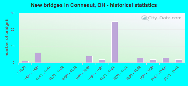
- New bridges - historical statistics
- 1Before 1900
- 61900-1909
- 41940-1949
- 21950-1959
- 251960-1969
- 31980-1989
- 21990-1999
- 32000-2009
- 22010-2019
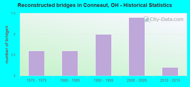
- Reconstructed bridges - Historical Statistics
- 31970-1979
- 31980-1989
- 51990-1999
- 72000-2009
- 12010-2019
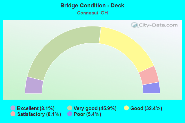
- Bridge Condition - Deck
- 8.1%Excellent
- 45.9%Very good
- 32.4%Good
- 8.1%Satisfactory
- 5.4%Poor
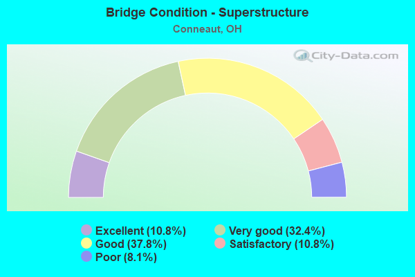
- Bridge Condition - Superstructure
- 10.8%Excellent
- 32.4%Very good
- 37.8%Good
- 10.8%Satisfactory
- 8.1%Poor
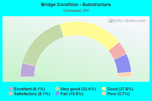
- Bridge Condition - Substructure
- 8.1%Excellent
- 32.4%Very good
- 37.8%Good
- 8.1%Satisfactory
- 10.8%Fair
- 2.7%Poor
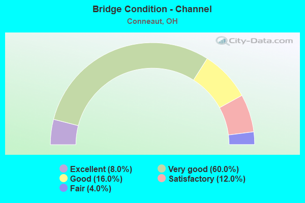
- Bridge Condition - Channel
- 8.0%Excellent
- 60.0%Very good
- 16.0%Good
- 12.0%Satisfactory
- 4.0%Fair
Find on map >> Show street view
Structure Number: 400963, Location: JCT OF SR 7 AND IR 90 (Lat: 41.916589, Lng: -80.568550), Route carried "under" structure: Interstate 90, Year Built: 1960, Structure Length: 0. m, Average Daily Traffic: 19,820 (year 2015), Truck Traffic: 30%, Features Intersected: SR 7, Facility Carried by Structure: SR 7
Minimum Vertical Clearance: 5.33m (17.49ft), Kilometerpoint: 41.489, Lanes on structure: 2, Lanes under structure: 4, Material/Design: Steel continuous, Design/Construction: Stringer/Multi-beam, Length of Maximum Span: 26.5m (86.9ft)
Find on map >> Show street view
Structure Number: 40447, Location: 2.61 MI E OF SR 84 (Lat: 41.899589, Lng: -80.623119), Route carried "under" structure: County highway 22, Year Built: 1960, Structure Length: 0. m, Average Daily Traffic: 403 (year 2015), Truck Traffic: 5%, Features Intersected: IR 90, Facility Carried by Structure: I.R. 90
Minimum Vertical Clearance: 4.98m (16.34ft), Kilometerpoint: 4.780, Lanes on structure: 2, Lanes under structure: 2, Material/Design: Concrete continuous, Design/Construction: Slab, Length of Maximum Span: 13.1m (43.0ft)
Find on map >> Show street view
Structure Number: 4045, Location: 2.61 MI E OF SR 84 (Lat: 41.899261, Lng: -80.622869), Route carried "under" structure: County highway 22, Year Built: 1960, Structure Length: 0. m, Average Daily Traffic: 403 (year 2015), Truck Traffic: 5%, Features Intersected: IR 90, Facility Carried by Structure: I.R. 90
Minimum Vertical Clearance: 4.37m (14.34ft), Kilometerpoint: 4.812, Lanes on structure: 2, Lanes under structure: 2, Material/Design: Concrete continuous, Design/Construction: Slab, Length of Maximum Span: 13.1m (43.0ft)
Find on map >> Show street view
Structure Number: 404535, Location: 1.90 MI W OF SR 7 (Lat: 41.906789, Lng: -80.603411), Route carried "under" structure: Interstate 90, Year Built: 1960, Structure Length: 0. m, Average Daily Traffic: 25,343 (year 2016), Truck Traffic: 32%, Features Intersected: KEEFUS RD CR-421, Facility Carried by Structure: KEEFUS ROAD CR 421
Minimum Vertical Clearance: 5.79m (19.00ft), Kilometerpoint: 38.415, Lanes on structure: 2, Lanes under structure: 4, Material/Design: Steel continuous, Design/Construction: Stringer/Multi-beam, Length of Maximum Span: 32.1m (105.3ft)
Find on map >> Show street view
Structure Number: 404594, Location: 1.22 MI W OF SR 7 (Lat: 41.910689, Lng: -80.590669), Route carried "under" structure: Interstate 90, Year Built: 1960, Structure Length: 0. m, Average Daily Traffic: 25,343 (year 2016), Truck Traffic: 32%, Features Intersected: PARRISH RD MR-372M, Facility Carried by Structure: PARRISH RD MR-372M
Minimum Vertical Clearance: 5.97m (19.59ft), Kilometerpoint: 39.542, Lanes on structure: 2, Lanes under structure: 4, Material/Design: Steel continuous, Design/Construction: Stringer/Multi-beam, Length of Maximum Span: 26.5m (86.9ft)
Find on map >> Show street view
Structure Number: 404683, Location: 0.75 MI E OF SR 7 (Lat: 41.920131, Lng: -80.555239), Route carried "under" structure: Interstate 90, Year Built: 1960, Structure Length: 0. m, Average Daily Traffic: 22,736 (year 2016), Truck Traffic: 28%, Features Intersected: DORMAN RD MR-295, Facility Carried by Structure: DORMAN ROAD MR-295
Minimum Vertical Clearance: 5.33m (17.49ft), Kilometerpoint: 42.673, Lanes on structure: 2, Lanes under structure: 4, Material/Design: Steel continuous, Design/Construction: Stringer/Multi-beam, Length of Maximum Span: 25.9m (85.0ft)
Find on map >> Show street view
Structure Number: 404713, Location: 1.48 MI E OF SR 7 (Lat: 41.925289, Lng: -80.542800), Route carried "under" structure: Interstate 90, Year Built: 1960, Structure Length: 0. m, Average Daily Traffic: 22,736 (year 2016), Truck Traffic: 28%, Features Intersected: MIDDLE RD MR-351, Facility Carried by Structure: MIDDLE ROAD MR-351
Minimum Vertical Clearance: 5.18m (16.99ft), Kilometerpoint: 43.851, Lanes on structure: 2, Lanes under structure: 4, Material/Design: Steel continuous, Design/Construction: Stringer/Multi-beam, Length of Maximum Span: 28.7m (94.2ft)
Find on map >> Show street view
Structure Number: 404748, Location: 1.92 MI E OF SR 11 (Lat: 41.929531, Lng: -80.535550), Route carried "under" structure: County highway 426, Year Built: 1960, Structure Length: 0. m, Average Daily Traffic: 759 (year 2015), Truck Traffic: 5%, Features Intersected: IR 90, Facility Carried by Structure: I.R. 90
Minimum Vertical Clearance: 4.57m (14.99ft), Kilometerpoint: 7.532, Lanes on structure: 2, Lanes under structure: 2, Material/Design: Concrete continuous, Design/Construction: Slab, Length of Maximum Span: 13.4m (44.0ft)
Find on map >> Show street view
Structure Number: 404772, Location: 1.92 MI E OF SR 11 (Lat: 41.929161, Lng: -80.535331), Route carried "under" structure: County highway 426, Year Built: 1960, Structure Length: 0. m, Average Daily Traffic: 759 (year 2015), Truck Traffic: 5%, Features Intersected: IR 90, Facility Carried by Structure: I.R. 90
Minimum Vertical Clearance: 4.32m (14.17ft), Kilometerpoint: 7.500, Lanes on structure: 2, Lanes under structure: 2, Material/Design: Concrete continuous, Design/Construction: Slab, Length of Maximum Span: 13.1m (43.0ft)