Bridge Statistics for Cordele, Georgia (GA)
Condition, Traffic, Stress, Structural Evaluation, Project Costs
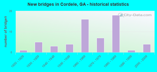
- New bridges - historical statistics
- 11920-1929
- 51930-1939
- 31940-1949
- 41950-1959
- 161960-1969
- 71970-1979
- 181980-1989
- 11990-1999
- 42000-2009

- Reconstructed bridges - Historical Statistics
- 11950-1959
- 01960-1969
- 01970-1979
- 21980-1989
- 21990-1999
- 42000-2009
- 32010-2019


- Bridge Condition - Deck
- 89.7%Good
- 7.7%Satisfactory
- 2.6%Fair

- Bridge Condition - Superstructure
- 38.5%Very good
- 53.8%Good
- 2.6%Satisfactory
- 5.1%Fair

- Bridge Condition - Substructure
- 89.7%Good
- 7.7%Satisfactory
- 2.6%Fair

- Bridge Condition - Channel
- 55.0%Very good
- 20.0%Good
- 12.5%Satisfactory
- 12.5%Fair
Find on map >> Show street view
Structure Number: 810001, Location: 1.5 MILE SOUTH OF CORDELE (Lat: 31.931047, Lng: -83.778039), Route carried "on" structure: US 41, Year Built: 1928, Year Reconstructed: 1955, Status: Open, Structure Length: 2.74m (8.99ft), Average Daily Traffic: 3,210 (year 2012), Truck Traffic: 1%, Average Future Daily Traffic: 4,815 (year 2032), Design Load: H 15, Features Intersected: CEDAR CREEK
Minimum Vertical Clearance: 30+ m (98+ ft), Kilometerpoint: 16.093, Lanes on structure: 2, Base Highway Network: Yes, Owner: State Highway Agency, Approaching Roadway Width: 7.3m (24.0ft), Material/Design: Concrete, Design/Construction: Tee Beam, Number Of Spans In Main Unit: 3, Length of Maximum Span: 9.1m (29.9ft), Curb or Sidewalk Widths: Left: 0.6m (2.0ft), Right: 0.6m (2.0ft), Curb-To-Curb Width: 8.5m (27.9ft), Out-to-Out Width: 10.4m (34.1ft)
Condition: Deck: Good, Superstructure: Good, Substructure: Good, Channel: Very good, Operating Rating: 44.4 metric tons, Method Used To Determine Operating Rating: Load Factor (LF), Inventory Rating: 26.3 metric tons, Method Used To Determine Inventory Rating: Load Factor (LF), Structural Evaluation: Equal to present minimum criteria, Deck Geometry: Meets minimum limits, Waterway Adequacy: Equal to present desirable criteria, Approach Roadway Alignment: Equal to present minimum criteria, Length Of Structure Improvement: 42.98m (141.01ft), Designated Inspection Frequency: Every 24 months, Inspection Date: July 2021, Bridge Improvement Cost: $352,000, Roadway Improvement Cost: $35,000, Total Project Cost: $527,000, Deck Structure Type: Concrete Cast-file-Place, Wearing Surface/Protective System: Wearing Surface: Bituminous
Find on map >> Show street view
Structure Number: 810002, Location: CORDELE-NW SECTION (Lat: 31.981147, Lng: -83.785078), Route carried "on" structure: US 41, Year Built: 1952, Status: Open, Structure Length: 5.06m (16.60ft), Average Daily Traffic: 6,750 (year 2012), Truck Traffic: 1%, Average Future Daily Traffic: 10,125 (year 2032), Design Load: HS 20+Mod, Features Intersected: NORFOLK SOUTHERN RR
Minimum Vertical Clearance: 30+ m (98+ ft), Kilometerpoint: 22.531, Lanes on structure: 4, Base Highway Network: Yes, Owner: State Highway Agency, Approaching Roadway Width: 14.6m (47.9ft), Skew: 22 degrees, Material/Design: Steel, Design/Construction: Stringer/Multi-beam, Number Of Spans In Main Unit: 5, Length of Maximum Span: 12.8m (42.0ft), Curb or Sidewalk Widths: Left: 0.6m (2.0ft), Right: 0.6m (2.0ft), Curb-To-Curb Width: 17.7m (58.1ft), Out-to-Out Width: 19.5m (64.0ft)
Condition: Deck: Satisfactory, Superstructure: Good, Substructure: Good, Operating Rating: 54.4 metric tons, Method Used To Determine Operating Rating: Load Factor (LF), Inventory Rating: 32.6 metric tons, Method Used To Determine Inventory Rating: Load Factor (LF), Structural Evaluation: Better than present minimum criteria, Deck Geometry: Somewhat better than minimum adequacy, Underclear: Somewhat better than minimum adequacy, Approach Roadway Alignment: Equal to present desirable criteria, Designated Inspection Frequency: Every 24 months, Inspection Date: August 2021, Bridge Improvement Cost: $1,002,000, Roadway Improvement Cost: $100,000, Total Project Cost: $1,504,000, Deck Structure Type: Concrete Cast-file-Place
Find on map >> Show street view
Structure Number: 810003, Location: CORDELE-NW SECTION (Lat: 31.983919, Lng: -83.790558), Route carried "on" structure: US 41, Year Built: 1951, Status: Open, Structure Length: 5.49m (18.01ft), Average Daily Traffic: 6,750 (year 2012), Truck Traffic: 1%, Average Future Daily Traffic: 10,125 (year 2032), Design Load: HS 20+Mod, Features Intersected: GUM CREEK
Minimum Vertical Clearance: 30+ m (98+ ft), Kilometerpoint: 22.531, Lanes on structure: 4, Base Highway Network: Yes, Owner: State Highway Agency, Approaching Roadway Width: 14.6m (47.9ft), Skew: 10 degrees, Material/Design: Concrete, Design/Construction: Tee Beam, Number Of Spans In Main Unit: 6, Length of Maximum Span: 9.1m (29.9ft), Curb or Sidewalk Widths: Left: 0.6m (2.0ft), Right: 0.6m (2.0ft), Curb-To-Curb Width: 17.7m (58.1ft), Out-to-Out Width: 19.5m (64.0ft)
Condition: Deck: Good, Superstructure: Good, Substructure: Good, Channel: Very good, Operating Rating: 56.2 metric tons, Method Used To Determine Operating Rating: Load Factor (LF), Inventory Rating: 33.5 metric tons, Method Used To Determine Inventory Rating: Load Factor (LF), Structural Evaluation: Better than present minimum criteria, Deck Geometry: Somewhat better than minimum adequacy, Waterway Adequacy: Equal to present desirable criteria, Approach Roadway Alignment: Equal to present desirable criteria, Designated Inspection Frequency: Every 24 months, Underwater Inspection Frequency: Every 60 months, Inspection Date: August 2021, Underwater Inspection Date: March 2021, Bridge Improvement Cost: $1,087,000, Roadway Improvement Cost: $109,000, Total Project Cost: $1,630,000, Deck Structure Type: Concrete Cast-file-Place, Wearing Surface/Protective System: Wearing Surface: Epoxy Overlay
Find on map >> Show street view
Structure Number: 810004, Location: CORDELE-NW SECTION (Lat: 31.983550, Lng: -83.791089), Route carried "on" structure: City street 1305, Year Built: 1982, Status: Open, Structure Length: 5.49m (18.01ft), Average Daily Traffic: 1,930 (year 2012), Truck Traffic: 1%, Average Future Daily Traffic: 2,895 (year 2032), Design Load: HS 20, Features Intersected: GUM CREEK, Facility Carried by Structure: JOE WRIGHT DRIVE
Minimum Vertical Clearance: 30+ m (98+ ft), Kilometerpoint: 3.219, Lanes on structure: 2, Base Highway Network: Yes, Owner: County Highway Agency, Approaching Roadway Width: 7.3m (24.0ft), Material/Design: Concrete, Design/Construction: Slab, Number Of Spans In Main Unit: 6, Length of Maximum Span: 9.1m (29.9ft), Curb or Sidewalk Widths: Left: 0.2m (0.7ft), Right: 0.2m (0.7ft), Curb-To-Curb Width: 12.4m (40.7ft), Out-to-Out Width: 13.4m (44.0ft)
Condition: Deck: Good, Superstructure: Good, Substructure: Good, Channel: Good, Operating Rating: 41.7 metric tons, Method Used To Determine Operating Rating: Load Factor (LF), Inventory Rating: 24.4 metric tons, Method Used To Determine Inventory Rating: Load Factor (LF), Structural Evaluation: Equal to present minimum criteria, Deck Geometry: Better than present minimum criteria, Waterway Adequacy: Equal to present desirable criteria, Approach Roadway Alignment: Better than present minimum criteria, Designated Inspection Frequency: Every 24 months, Underwater Inspection Frequency: Every 60 months, Inspection Date: August 2021, Underwater Inspection Date: March 2021, Bridge Improvement Cost: $703,000, Roadway Improvement Cost: $70,000, Total Project Cost: $1,055,000, Deck Structure Type: Concrete Precast Panels, Wearing Surface/Protective System: Wearing Surface: Bituminous
Find on map >> Show street view
Structure Number: 810007, Location: 2.5 MI E OF CORDELE (Lat: 31.950058, Lng: -83.704739), Route carried "on" structure: US 280, Year Built: 1943, Year Reconstructed: 1986, Status: Open, Structure Length: 0.85m (2.79ft), Average Daily Traffic: 2,910 (year 2012), Truck Traffic: 18%, Average Future Daily Traffic: 4,365 (year 2032), Design Load: HS 20+Mod, Features Intersected: DEEP CREEK
Minimum Vertical Clearance: 30+ m (98+ ft), Kilometerpoint: 22.531, Lanes on structure: 2, Base Highway Network: Yes, Owner: State Highway Agency, Approaching Roadway Width: 8.5m (27.9ft), Material/Design: Concrete, Design/Construction: Culvert, Number Of Spans In Main Unit: 3, Length of Maximum Span: 2.4m (7.9ft)
Condition: Channel: Satisfactory, Culverts: Good, Operating Rating: 44.4 metric tons, Method Used To Determine Operating Rating: Field evaluation and documented engineering judgment, Inventory Rating: 32.6 metric tons, Method Used To Determine Inventory Rating: Field evaluation and documented engineering judgment, Structural Evaluation: Better than present minimum criteria, Waterway Adequacy: Equal to present desirable criteria, Approach Roadway Alignment: Equal to present desirable criteria, Designated Inspection Frequency: Every 24 months, Inspection Date: August 2021, Bridge Improvement Cost: $109,000, Roadway Improvement Cost: $11,000, Total Project Cost: $164,000
Find on map >> Show street view
Structure Number: 810009, Location: 4.7 MI E OF CORDELE (Lat: 31.957397, Lng: -83.671008), Route carried "on" structure: US 280, Year Built: 1942, Status: Open, Structure Length: 0.79m (2.59ft), Average Daily Traffic: 2,910 (year 2012), Truck Traffic: 18%, Average Future Daily Traffic: 4,365 (year 2032), Design Load: H 15, Features Intersected: REDOAK CREEK
Minimum Vertical Clearance: 30+ m (98+ ft), Kilometerpoint: 25.750, Lanes on structure: 2, Base Highway Network: Yes, Owner: State Highway Agency, Approaching Roadway Width: 8.5m (27.9ft), Material/Design: Concrete, Design/Construction: Culvert, Number Of Spans In Main Unit: 3, Length of Maximum Span: 2.4m (7.9ft)
Condition: Channel: Very good, Culverts: Good, Operating Rating: 38.1 metric tons, Method Used To Determine Operating Rating: Load Factor (LF), Inventory Rating: 22.6 metric tons, Method Used To Determine Inventory Rating: Load Factor (LF), Structural Evaluation: Equal to present minimum criteria, Waterway Adequacy: Equal to present desirable criteria, Approach Roadway Alignment: Equal to present desirable criteria, Designated Inspection Frequency: Every 24 months, Inspection Date: August 2021, Bridge Improvement Cost: $102,000, Roadway Improvement Cost: $10,000, Total Project Cost: $152,000
Find on map >> Show street view
Structure Number: 810013, Location: APP 3 MI S OF CORDELE (Lat: 31.906858, Lng: -83.737678), Route carried "on" structure: Ramp State highway 33, Year Built: 1960, Status: Open, Structure Length: 6.43m (21.10ft), Average Daily Traffic: 930 (year 2012), Truck Traffic: 1%, Average Future Daily Traffic: 1,395 (year 2032), Design Load: HS 20+Mod, Features Intersected: I-75 96.78N, Facility Carried by Structure: ROCK-WENONA HOUSE
Minimum Vertical Clearance: 30+ m (98+ ft), Kilometerpoint: 3.219, Lanes on structure: 2, Lanes under structure: 6, Base Highway Network: Yes, Owner: State Highway Agency, Approaching Roadway Width: 8.5m (27.9ft), Material/Design: Steel continuous, Design/Construction: Stringer/Multi-beam, Number Of Spans In Main Unit: 4, Length of Maximum Span: 21.6m (70.9ft), Curb or Sidewalk Widths: Left: 0.6m (2.0ft), Right: 0.6m (2.0ft), Curb-To-Curb Width: 8.5m (27.9ft), Out-to-Out Width: 10.5m (34.4ft)
Condition: Deck: Satisfactory, Superstructure: Very good, Substructure: Good, Operating Rating: 61.6 metric tons, Method Used To Determine Operating Rating: Load Factor (LF), Inventory Rating: 37.1 metric tons, Method Used To Determine Inventory Rating: Load Factor (LF), Structural Evaluation: Better than present minimum criteria, Deck Geometry: High priority of corrective action, Underclear: Meets minimum limits, Approach Roadway Alignment: Better than present minimum criteria, Designated Inspection Frequency: Every 24 months, Inspection Date: August 2021, Bridge Improvement Cost: $824,000, Roadway Improvement Cost: $82,000, Total Project Cost: $1,237,000, Deck Structure Type: Concrete Cast-file-Place
Find on map >> Show street view
Structure Number: 810018, Location: APP 7 MI. SW OF CORDELE (Lat: 31.913139, Lng: -83.853039), Route carried "on" structure: State highway 300, Year Built: 1981, Status: Open, Structure Length: 4.39m (14.40ft), Average Daily Traffic: 9,010 (year 2012), Truck Traffic: 1%, Average Future Daily Traffic: 13,515 (year 2032), Design Load: HS 20, Features Intersected: CEDAR CREEK
Minimum Vertical Clearance: 30+ m (98+ ft), Kilometerpoint: 9.656, Lanes on structure: 2, Base Highway Network: Yes, Owner: State Highway Agency, Approaching Roadway Width: 9.1m (29.9ft), Skew: 12 degrees, Material/Design: Concrete, Design/Construction: Tee Beam, Number Of Spans In Main Unit: 4, Length of Maximum Span: 11.0m (36.1ft), Curb-To-Curb Width: 13.0m (42.7ft), Out-to-Out Width: 14.0m (45.9ft)
Condition: Deck: Good, Superstructure: Good, Substructure: Good, Channel: Very good, Operating Rating: 34.4 metric tons, Method Used To Determine Operating Rating: Load Factor (LF), Inventory Rating: 20.8 metric tons, Method Used To Determine Inventory Rating: Load Factor (LF), Structural Evaluation: Somewhat better than minimum adequacy, Deck Geometry: Superior to present desirable criteria, Waterway Adequacy: Equal to present desirable criteria, Approach Roadway Alignment: Equal to present desirable criteria, Designated Inspection Frequency: Every 24 months, Inspection Date: July 2021, Bridge Improvement Cost: $563,000, Roadway Improvement Cost: $56,000, Total Project Cost: $844,000, Deck Structure Type: Concrete Cast-file-Place
Find on map >> Show street view
Structure Number: 810019, Location: APP 7 MI. SW OF CORDELE (Lat: 31.913169, Lng: -83.853250), Route carried "on" structure: State highway 300, Year Built: 1981, Status: Open, Structure Length: 4.39m (14.40ft), Average Daily Traffic: 9,010 (year 2012), Truck Traffic: 1%, Average Future Daily Traffic: 13,515 (year 2032), Design Load: HS 20, Features Intersected: CEDAR CREEK
Minimum Vertical Clearance: 30+ m (98+ ft), Kilometerpoint: 9.656, Lanes on structure: 2, Base Highway Network: Yes, Owner: State Highway Agency, Approaching Roadway Width: 9.1m (29.9ft), Skew: 12 degrees, Material/Design: Concrete, Design/Construction: Tee Beam, Number Of Spans In Main Unit: 4, Length of Maximum Span: 11.0m (36.1ft), Curb or Sidewalk Widths: Left: 0.2m (0.7ft), Right: 0.2m (0.7ft), Curb-To-Curb Width: 13.0m (42.7ft), Out-to-Out Width: 14.0m (45.9ft)
Condition: Deck: Good, Superstructure: Good, Substructure: Good, Channel: Very good, Operating Rating: 34.4 metric tons, Method Used To Determine Operating Rating: Load Factor (LF), Inventory Rating: 20.8 metric tons, Method Used To Determine Inventory Rating: Load Factor (LF), Structural Evaluation: Somewhat better than minimum adequacy, Deck Geometry: Superior to present desirable criteria, Waterway Adequacy: Equal to present desirable criteria, Approach Roadway Alignment: Equal to present desirable criteria, Designated Inspection Frequency: Every 24 months, Inspection Date: July 2021, Bridge Improvement Cost: $563,000, Roadway Improvement Cost: $56,000, Total Project Cost: $844,000, Deck Structure Type: Concrete Cast-file-Place
Find on map >> Show street view
Structure Number: 810022, Location: 2.9 MI NE OF JCT I-75 (Lat: 32.006728, Lng: -83.737458), Route carried "on" structure: State highway 257, Year Built: 1957, Status: Open, Structure Length: 2.44m (8.01ft), Average Daily Traffic: 1,750 (year 2012), Truck Traffic: 1%, Average Future Daily Traffic: 2,625 (year 2032), Design Load: H 15, Features Intersected: GUM CREEK
Minimum Vertical Clearance: 30+ m (98+ ft), Kilometerpoint: 4.828, Lanes on structure: 2, Base Highway Network: Yes, Owner: State Highway Agency, Approaching Roadway Width: 7.3m (24.0ft), Material/Design: Prestressed concrete, Design/Construction: Channel Beam, Number Of Spans In Main Unit: 4, Length of Maximum Span: 6.1m (20.0ft), Curb or Sidewalk Widths: Left: 0.2m (0.7ft), Right: 0.2m (0.7ft), Curb-To-Curb Width: 8.2m (26.9ft), Out-to-Out Width: 9.6m (31.5ft)
Condition: Deck: Good, Superstructure: Good, Substructure: Good, Channel: Very good, Operating Rating: 45.3 metric tons, Method Used To Determine Operating Rating: Load Factor (LF), Inventory Rating: 27.2 metric tons, Method Used To Determine Inventory Rating: Load Factor (LF), Structural Evaluation: Equal to present minimum criteria, Deck Geometry: Meets minimum limits, Waterway Adequacy: Equal to present desirable criteria, Approach Roadway Alignment: Equal to present minimum criteria, Length Of Structure Improvement: 42.70m (140.09ft), Designated Inspection Frequency: Every 24 months, Inspection Date: August 2021, Bridge Improvement Cost: $313,000, Roadway Improvement Cost: $31,000, Total Project Cost: $469,000, Deck Structure Type: Concrete Precast Panels, Wearing Surface/Protective System: Wearing Surface: Bituminous
Find on map >> Show street view
Structure Number: 810023, Location: APP 2.4 MI S OF CORDELE (Lat: 31.925608, Lng: -83.745339), Route carried "on" structure: County highway 355, Year Built: 1960, Status: Open, Structure Length: 6.74m (22.11ft), Average Daily Traffic: 680 (year 2012), Truck Traffic: 1%, Average Future Daily Traffic: 1,020 (year 2032), Design Load: HS 15, Features Intersected: I-75 MP 98.15, Facility Carried by Structure: OLD HATLEY ROAD
Minimum Vertical Clearance: 30+ m (98+ ft), Kilometerpoint: 3.219, Lanes on structure: 2, Lanes under structure: 6, Base Highway Network: Yes, Owner: State Highway Agency, Approaching Roadway Width: 6.1m (20.0ft), Skew: 2 degrees, Material/Design: Steel continuous, Design/Construction: Stringer/Multi-beam, Number Of Spans In Main Unit: 4, Length of Maximum Span: 22.9m (75.1ft), Curb or Sidewalk Widths: Left: 0.6m (2.0ft), Right: 0.6m (2.0ft), Curb-To-Curb Width: 7.3m (24.0ft), Out-to-Out Width: 9.2m (30.2ft)
Condition: Deck: Good, Superstructure: Good, Substructure: Good, Operating Rating: 29.0 metric tons, Method Used To Determine Operating Rating: Load Factor (LF), Inventory Rating: 17.2 metric tons, Method Used To Determine Inventory Rating: Load Factor (LF), Structural Evaluation: Meets minimum limits, Deck Geometry: Meets minimum limits, Underclear: Somewhat better than minimum adequacy, Approach Roadway Alignment: Better than present minimum criteria, Designated Inspection Frequency: Every 24 months, Inspection Date: August 2021, Bridge Improvement Cost: $863,000, Roadway Improvement Cost: $86,000, Total Project Cost: $1,295,000, Deck Structure Type: Concrete Cast-file-Place
Find on map >> Show street view
Structure Number: 810025, Location: 2.6 MI S OF CORDELLE (Lat: 31.923228, Lng: -83.744239), Route carried "on" structure: Interstate 75, Year Built: 1960, Status: Open, Structure Length: 1.07m (3.51ft), Average Daily Traffic: 35,210 (year 2012), Truck Traffic: 1%, Average Future Daily Traffic: 52,815 (year 2032), Design Load: HS 20+Mod, Features Intersected: CEDAR CREEK TRIB.
Minimum Vertical Clearance: 30+ m (98+ ft), Kilometerpoint: 157.716, Lanes on structure: 6, Base Highway Network: Yes, Owner: State Highway Agency, Approaching Roadway Width: 34.1m (111.9ft), Skew: 10 degrees, Material/Design: Concrete, Design/Construction: Culvert, Number Of Spans In Main Unit: 4, Length of Maximum Span: 2.4m (7.9ft)
Condition: Channel: Very good, Culverts: Good, Operating Rating: 44.4 metric tons, Method Used To Determine Operating Rating: Field evaluation and documented engineering judgment, Inventory Rating: 32.6 metric tons, Method Used To Determine Inventory Rating: Field evaluation and documented engineering judgment, Structural Evaluation: Better than present minimum criteria, Waterway Adequacy: Equal to present desirable criteria, Approach Roadway Alignment: Equal to present desirable criteria, Designated Inspection Frequency: Every 24 months, Inspection Date: September 2021, Bridge Improvement Cost: $286,000, Roadway Improvement Cost: $29,000, Total Project Cost: $429,000
Find on map >> Show street view
Structure Number: 810026, Location: 2.1 MI S OF CORDELLE (Lat: 31.930169, Lng: -83.746728), Route carried "on" structure: Interstate 75, Year Built: 1960, Year Reconstructed: 1985, Status: Open, Structure Length: 1.62m (5.31ft), Average Daily Traffic: 35,210 (year 2012), Truck Traffic: 1%, Average Future Daily Traffic: 52,815 (year 2032), Design Load: HS 20+Mod, Features Intersected: CEDAR CREEK TRIB.
Minimum Vertical Clearance: 30+ m (98+ ft), Kilometerpoint: 157.716, Lanes on structure: 6, Base Highway Network: Yes, Owner: State Highway Agency, Approaching Roadway Width: 40.2m (131.9ft), Skew: 30 degrees, Material/Design: Concrete, Design/Construction: Culvert, Number Of Spans In Main Unit: 6, Length of Maximum Span: 2.4m (7.9ft)
Condition: Channel: Good, Culverts: Good, Operating Rating: 44.4 metric tons, Method Used To Determine Operating Rating: Field evaluation and documented engineering judgment, Inventory Rating: 32.6 metric tons, Method Used To Determine Inventory Rating: Field evaluation and documented engineering judgment, Structural Evaluation: Better than present minimum criteria, Waterway Adequacy: Equal to present desirable criteria, Approach Roadway Alignment: Equal to present desirable criteria, Designated Inspection Frequency: Every 24 months, Inspection Date: September 2021, Bridge Improvement Cost: $433,000, Roadway Improvement Cost: $43,000, Total Project Cost: $649,000
Find on map >> Show street view
Structure Number: 810027, Location: 0.6 MI S OF CORDELLE (Lat: 31.951650, Lng: -83.750128), Route carried "on" structure: Interstate 75, Year Built: 1960, Status: Open, Structure Length: 0.94m (3.08ft), Average Daily Traffic: 41,370 (year 2012), Truck Traffic: 1%, Average Future Daily Traffic: 62,055 (year 2032), Design Load: HS 20+Mod, Features Intersected: CEDAR CREEK
Minimum Vertical Clearance: 30+ m (98+ ft), Kilometerpoint: 160.934, Lanes on structure: 6, Base Highway Network: Yes, Owner: State Highway Agency, Approaching Roadway Width: 40.2m (131.9ft), Skew: 10 degrees, Material/Design: Concrete, Design/Construction: Culvert, Number Of Spans In Main Unit: 4, Length of Maximum Span: 1.8m (5.9ft)
Condition: Channel: Very good, Culverts: Good, Operating Rating: 44.4 metric tons, Method Used To Determine Operating Rating: Field evaluation and documented engineering judgment, Inventory Rating: 32.6 metric tons, Method Used To Determine Inventory Rating: Field evaluation and documented engineering judgment, Structural Evaluation: Better than present minimum criteria, Waterway Adequacy: Equal to present desirable criteria, Approach Roadway Alignment: Equal to present desirable criteria, Designated Inspection Frequency: Every 24 months, Inspection Date: August 2021, Bridge Improvement Cost: $253,000, Roadway Improvement Cost: $25,000, Total Project Cost: $380,000
Find on map >> Show street view
Structure Number: 810028, Location: CORDELE - EAST SECTION (Lat: 31.959972, Lng: -83.751542), Route carried "on" structure: Interstate 75, Year Built: 1960, Year Reconstructed: 2010, Status: Open, Structure Length: 4.82m (15.81ft), Average Daily Traffic: 41,890 (year 2012), Truck Traffic: 1%, Average Future Daily Traffic: 62,835 (year 2032), Design Load: HS 20+Mod, Features Intersected: SR 30
Minimum Vertical Clearance: 30+ m (98+ ft), Kilometerpoint: 162.544, Lanes on structure: 6, Lanes under structure: 4, Base Highway Network: Yes, Owner: State Highway Agency, Approaching Roadway Width: 39.6m (129.9ft), Skew: 32 degrees, Material/Design: Steel, Design/Construction: Stringer/Multi-beam, Number Of Spans In Main Unit: 4, Length of Maximum Span: 14.3m (46.9ft), Curb-To-Curb Width: 39.6m (129.9ft), Out-to-Out Width: 41.8m (137.1ft)
Condition: Deck: Good, Superstructure: Very good, Substructure: Good, Operating Rating: 63.5 metric tons, Method Used To Determine Operating Rating: Load Factor (LF), Inventory Rating: 38.1 metric tons, Method Used To Determine Inventory Rating: Load Factor (LF), Structural Evaluation: Better than present minimum criteria, Deck Geometry: Superior to present desirable criteria, Underclear: Somewhat better than minimum adequacy, Approach Roadway Alignment: Equal to present desirable criteria, Designated Inspection Frequency: Every 24 months, Inspection Date: August 2021, Bridge Improvement Cost: $1,291,000, Roadway Improvement Cost: $129,000, Total Project Cost: $1,936,000, Deck Structure Type: Concrete Cast-file-Place
Find on map >> Show street view
Structure Number: 81003, Location: 0.2 MI N OF JCT SR 30 (Lat: 31.962989, Lng: -83.751908), Route carried "on" structure: Interstate 75, Year Built: 1960, Year Reconstructed: 2010, Status: Open, Structure Length: 4.45m (14.60ft), Average Daily Traffic: 41,890 (year 2012), Truck Traffic: 1%, Average Future Daily Traffic: 62,835 (year 2032), Design Load: HS 20+Mod, Features Intersected: CSX RAILROAD
Minimum Vertical Clearance: 30+ m (98+ ft), Kilometerpoint: 162.544, Lanes on structure: 8, Base Highway Network: Yes, Owner: State Highway Agency, Approaching Roadway Width: 39.6m (129.9ft), Skew: 32 degrees, Material/Design: Steel, Design/Construction: Stringer/Multi-beam, Number Of Spans In Main Unit: 3, Length of Maximum Span: 15.8m (51.8ft), Curb-To-Curb Width: 39.6m (129.9ft), Out-to-Out Width: 41.9m (137.5ft)
Condition: Deck: Good, Superstructure: Very good, Substructure: Good, Operating Rating: 59.8 metric tons, Method Used To Determine Operating Rating: Load Factor (LF), Inventory Rating: 35.3 metric tons, Method Used To Determine Inventory Rating: Load Factor (LF), Structural Evaluation: Better than present minimum criteria, Deck Geometry: Superior to present desirable criteria, Underclear: Meets minimum limits, Approach Roadway Alignment: Equal to present desirable criteria, Designated Inspection Frequency: Every 24 months, Inspection Date: August 2021, Bridge Improvement Cost: $1,193,000, Roadway Improvement Cost: $119,000, Total Project Cost: $1,789,000, Deck Structure Type: Concrete Cast-file-Place
Find on map >> Show street view
Structure Number: 810032, Location: CORDELLE-EAST SECTION (Lat: 31.966617, Lng: -83.752600), Route carried "on" structure: Interstate 75, Year Built: 1960, Year Reconstructed: 2009, Status: Open, Structure Length: 4.57m (14.99ft), Average Daily Traffic: 41,890 (year 2012), Truck Traffic: 1%, Average Future Daily Traffic: 62,835 (year 2032), Design Load: HS 20+Mod, Features Intersected: M-1311 13TH AVE.
Minimum Vertical Clearance: 30+ m (98+ ft), Kilometerpoint: 162.544, Lanes on structure: 6, Lanes under structure: 2, Base Highway Network: Yes, Owner: State Highway Agency, Approaching Roadway Width: 38.4m (126.0ft), Skew: 31 degrees, Material/Design: Prestressed concrete, Design/Construction: Stringer/Multi-beam, Number Of Spans In Main Unit: 3, Length of Maximum Span: 18.3m (60.0ft), Curb-To-Curb Width: 38.4m (126.0ft), Out-to-Out Width: 40.3m (132.2ft)
Condition: Deck: Good, Superstructure: Very good, Substructure: Good, Operating Rating: 63.5 metric tons, Method Used To Determine Operating Rating: Load Factor (LF), Inventory Rating: 36.2 metric tons, Method Used To Determine Inventory Rating: Load Factor (LF), Structural Evaluation: Better than present minimum criteria, Deck Geometry: Superior to present desirable criteria, Underclear: Somewhat better than minimum adequacy, Approach Roadway Alignment: Equal to present desirable criteria, Designated Inspection Frequency: Every 24 months, Inspection Date: August 2021, Bridge Improvement Cost: $1,225,000, Roadway Improvement Cost: $123,000, Total Project Cost: $1,838,000, Deck Structure Type: Concrete Cast-file-Place
Find on map >> Show street view
Structure Number: 810034, Location: CORDELE-EAST SECTION (Lat: 31.968228, Lng: -83.752769), Route carried "on" structure: Interstate 75, Year Built: 1960, Year Reconstructed: 2009, Status: Open, Structure Length: 4.60m (15.09ft), Average Daily Traffic: 41,890 (year 2012), Truck Traffic: 1%, Average Future Daily Traffic: 62,835 (year 2032), Design Load: HS 20+Mod, Features Intersected: CSX RAILROAD
Minimum Vertical Clearance: 30+ m (98+ ft), Kilometerpoint: 162.544, Lanes on structure: 4, Base Highway Network: Yes, Owner: State Highway Agency, Approaching Roadway Width: 39.0m (128.0ft), Skew: 32 degrees, Material/Design: Steel, Design/Construction: Stringer/Multi-beam, Number Of Spans In Main Unit: 3, Length of Maximum Span: 15.5m (50.9ft), Curb-To-Curb Width: 39.0m (128.0ft), Out-to-Out Width: 40.2m (131.9ft)
Condition: Deck: Good, Superstructure: Very good, Substructure: Good, Operating Rating: 45.3 metric tons, Method Used To Determine Operating Rating: Load Factor (LF), Inventory Rating: 27.2 metric tons, Method Used To Determine Inventory Rating: Load Factor (LF), Structural Evaluation: Equal to present minimum criteria, Deck Geometry: Superior to present desirable criteria, Underclear: Equal to present minimum criteria, Approach Roadway Alignment: Equal to present desirable criteria, Designated Inspection Frequency: Every 24 months, Inspection Date: August 2021, Bridge Improvement Cost: $912,000, Roadway Improvement Cost: $91,000, Total Project Cost: $1,368,000, Deck Structure Type: Concrete Cast-file-Place
Find on map >> Show street view
Structure Number: 810036, Location: APP 2 MI N OF CORDELE (Lat: 31.994569, Lng: -83.756858), Route carried "on" structure: Interstate 75, Year Built: 1960, Status: Open, Structure Length: 0.88m (2.89ft), Average Daily Traffic: 41,810 (year 2012), Truck Traffic: 1%, Average Future Daily Traffic: 62,715 (year 2032), Design Load: HS 20+Mod, Features Intersected: GUM CREEK TRIB.
Minimum Vertical Clearance: 30+ m (98+ ft), Kilometerpoint: 165.762, Lanes on structure: 6, Base Highway Network: Yes, Owner: State Highway Agency, Approaching Roadway Width: 40.2m (131.9ft), Skew: 10 degrees, Material/Design: Concrete, Design/Construction: Culvert, Number Of Spans In Main Unit: 3, Length of Maximum Span: 2.7m (8.9ft)
Condition: Channel: Good, Culverts: Good, Operating Rating: 44.4 metric tons, Method Used To Determine Operating Rating: Field evaluation and documented engineering judgment, Inventory Rating: 32.6 metric tons, Method Used To Determine Inventory Rating: Field evaluation and documented engineering judgment, Structural Evaluation: Better than present minimum criteria, Waterway Adequacy: Equal to present desirable criteria, Approach Roadway Alignment: Equal to present desirable criteria, Designated Inspection Frequency: Every 24 months, Inspection Date: August 2021, Bridge Improvement Cost: $237,000, Roadway Improvement Cost: $24,000, Total Project Cost: $355,000
Find on map >> Show street view
Structure Number: 810037, Location: APP 3 MI N OF CORDELE (Lat: 32.009339, Lng: -83.759158), Route carried "on" structure: Interstate 75, Year Built: 1960, Year Reconstructed: 2009, Status: Open, Structure Length: 3.29m (10.79ft), Average Daily Traffic: 41,740 (year 2012), Truck Traffic: 1%, Average Future Daily Traffic: 62,610 (year 2032), Design Load: HS 20+Mod, Features Intersected: GUM CREEK
Minimum Vertical Clearance: 30+ m (98+ ft), Kilometerpoint: 167.372, Lanes on structure: 6, Base Highway Network: Yes, Owner: State Highway Agency, Approaching Roadway Width: 23.8m (78.1ft), Skew: 30 degrees, Material/Design: Concrete, Design/Construction: Stringer/Multi-beam, Number Of Spans In Main Unit: 3, Length of Maximum Span: 11.0m (36.1ft), Curb-To-Curb Width: 47.5m (155.8ft), Out-to-Out Width: 55.2m (181.1ft)
Condition: Deck: Good, Superstructure: Very good, Substructure: Good, Channel: Very good, Operating Rating: 60.7 metric tons, Method Used To Determine Operating Rating: Load Factor (LF), Inventory Rating: 36.2 metric tons, Method Used To Determine Inventory Rating: Load Factor (LF), Structural Evaluation: Better than present minimum criteria, Deck Geometry: Superior to present desirable criteria, Waterway Adequacy: Equal to present desirable criteria, Approach Roadway Alignment: Equal to present desirable criteria, Designated Inspection Frequency: Every 24 months, Inspection Date: August 2021, Bridge Improvement Cost: $882,000, Roadway Improvement Cost: $88,000, Total Project Cost: $1,323,000, Deck Structure Type: Concrete Cast-file-Place
Find on map >> Show street view
Structure Number: 81004, Location: 5 MI NE OF CORDELE (Lat: 32.018489, Lng: -83.735239), Route carried "on" structure: County highway 1175, Year Built: 1986, Status: Open, Structure Length: 1.04m (3.41ft), Average Daily Traffic: 200 (year 2012), Truck Traffic: 1%, Average Future Daily Traffic: 300 (year 2032), Design Load: HS 20+Mod, Features Intersected: GUM CREEK TRIB., Facility Carried by Structure: SHARON CH ROAD
Minimum Vertical Clearance: 30+ m (98+ ft), Kilometerpoint: 0.000, Lanes on structure: 2, Base Highway Network: Yes, Owner: County Highway Agency, Approaching Roadway Width: 7.3m (24.0ft), Material/Design: Concrete, Design/Construction: Culvert, Number Of Spans In Main Unit: 3, Length of Maximum Span: 3.0m (9.8ft)
Condition: Channel: Very good, Culverts: Good, Operating Rating: 44.4 metric tons, Method Used To Determine Operating Rating: Field evaluation and documented engineering judgment, Inventory Rating: 32.6 metric tons, Method Used To Determine Inventory Rating: Field evaluation and documented engineering judgment, Structural Evaluation: Better than present minimum criteria, Waterway Adequacy: Equal to present minimum criteria, Approach Roadway Alignment: Equal to present minimum criteria, Designated Inspection Frequency: Every 24 months, Inspection Date: August 2021, Bridge Improvement Cost: $133,000, Roadway Improvement Cost: $13,000, Total Project Cost: $199,000
Find on map >> Show street view
Structure Number: 810042, Location: CORDELE-NW SECTION (Lat: 31.974450, Lng: -83.794319), Route carried "on" structure: City street 1304, Year Built: 1976, Status: Open, Structure Length: 3.66m (12.01ft), Average Daily Traffic: 1,460 (year 2012), Truck Traffic: 1%, Average Future Daily Traffic: 2,190 (year 2032), Design Load: HS 20, Features Intersected: GUM CREEK, Facility Carried by Structure: NORTH 15TH STREET
Minimum Vertical Clearance: 30+ m (98+ ft), Kilometerpoint: 1.609, Lanes on structure: 2, Base Highway Network: Yes, Owner: County Highway Agency, Approaching Roadway Width: 7.3m (24.0ft), Skew: 3 degrees, Material/Design: Concrete, Design/Construction: Tee Beam, Number Of Spans In Main Unit: 3, Length of Maximum Span: 12.2m (40.0ft), Curb-To-Curb Width: 14.2m (46.6ft), Out-to-Out Width: 14.9m (48.9ft)
Condition: Deck: Good, Superstructure: Good, Substructure: Good, Channel: Very good, Operating Rating: 37.1 metric tons, Method Used To Determine Operating Rating: Load Factor (LF), Inventory Rating: 22.6 metric tons, Method Used To Determine Inventory Rating: Load Factor (LF), Structural Evaluation: Equal to present minimum criteria, Deck Geometry: Superior to present desirable criteria, Waterway Adequacy: Equal to present desirable criteria, Approach Roadway Alignment: Equal to present desirable criteria, Designated Inspection Frequency: Every 24 months, Inspection Date: August 2021, Bridge Improvement Cost: $469,000, Roadway Improvement Cost: $47,000, Total Project Cost: $703,000, Deck Structure Type: Concrete Cast-file-Place
Find on map >> Show street view
Structure Number: 810043, Location: CORDELE-N SECTION (Lat: 31.982008, Lng: -83.774678), Route carried "on" structure: City street 1308, Year Built: 1978, Status: Open, Structure Length: 1.04m (3.41ft), Average Daily Traffic: 1,190 (year 2012), Truck Traffic: 1%, Average Future Daily Traffic: 1,785 (year 2032), Design Load: HS 20+Mod, Features Intersected: GUM CREEK TRIB., Facility Carried by Structure: SECOND ST NORTH
Minimum Vertical Clearance: 30+ m (98+ ft), Kilometerpoint: 3.219, Lanes on structure: 2, Base Highway Network: Yes, Owner: County Highway Agency, Approaching Roadway Width: 6.7m (22.0ft), Material/Design: Concrete, Design/Construction: Culvert, Number Of Spans In Main Unit: 3, Length of Maximum Span: 3.0m (9.8ft)
Condition: Channel: Fair, Culverts: Good, Operating Rating: 44.4 metric tons, Method Used To Determine Operating Rating: Field evaluation and documented engineering judgment, Inventory Rating: 32.6 metric tons, Method Used To Determine Inventory Rating: Field evaluation and documented engineering judgment, Structural Evaluation: Better than present minimum criteria, Waterway Adequacy: Equal to present minimum criteria, Approach Roadway Alignment: Equal to present minimum criteria, Designated Inspection Frequency: Every 24 months, Inspection Date: July 2021, Bridge Improvement Cost: $133,000, Roadway Improvement Cost: $13,000, Total Project Cost: $199,000
Find on map >> Show street view
Structure Number: 810054, Location: 0.9 MI E OF JCT SR 7 (Lat: 32.004228, Lng: -83.779389), Route carried "on" structure: County highway 1818, Year Built: 1954, Status: Open, Structure Length: 0.64m (2.10ft), Average Daily Traffic: 1,600 (year 2012), Truck Traffic: 1%, Average Future Daily Traffic: 2,400 (year 2032), Design Load: H 15, Features Intersected: GUM CREEK TRIB., Facility Carried by Structure: FARMERS MARKET RD
Minimum Vertical Clearance: 30+ m (98+ ft), Kilometerpoint: 1.609, Lanes on structure: 2, Base Highway Network: Yes, Owner: County Highway Agency, Approaching Roadway Width: 6.7m (22.0ft), Material/Design: Concrete, Design/Construction: Culvert, Number Of Spans In Main Unit: 2, Length of Maximum Span: 3.0m (9.8ft)
Condition: Channel: Satisfactory, Culverts: Good, Operating Rating: 41.7 metric tons, Method Used To Determine Operating Rating: Field evaluation and documented engineering judgment, Inventory Rating: 24.4 metric tons, Method Used To Determine Inventory Rating: Field evaluation and documented engineering judgment, Structural Evaluation: Equal to present minimum criteria, Waterway Adequacy: Equal to present desirable criteria, Approach Roadway Alignment: Equal to present desirable criteria, Designated Inspection Frequency: Every 24 months, Inspection Date: August 2021, Bridge Improvement Cost: $82,000, Roadway Improvement Cost: $8,000, Total Project Cost: $123,000
Find on map >> Show street view
Structure Number: 810055, Location: 1.8 MILES EAST OF CORDEL (Lat: 32.004039, Lng: -83.762828), Route carried "on" structure: County highway 1818, Year Built: 1961, Year Reconstructed: 2010, Status: Open, Structure Length: 3.29m (10.79ft), Average Daily Traffic: 1,600 (year 2012), Truck Traffic: 1%, Average Future Daily Traffic: 2,400 (year 2032), Design Load: HS 20, Features Intersected: GUM CREEK, Facility Carried by Structure: FARMERS MARKET RD
Minimum Vertical Clearance: 30+ m (98+ ft), Kilometerpoint: 3.219, Lanes on structure: 2, Base Highway Network: Yes, Owner: County Highway Agency, Approaching Roadway Width: 6.7m (22.0ft), Material/Design: Concrete, Design/Construction: Mixed types, Number Of Spans In Main Unit: 3, Length of Maximum Span: 11.0m (36.1ft), Curb or Sidewalk Widths: Left: 0.6m (2.0ft), Right: 0.6m (2.0ft), Curb-To-Curb Width: 15.5m (50.9ft), Out-to-Out Width: 17.3m (56.8ft)
Condition: Deck: Good, Superstructure: Good, Substructure: Good, Channel: Satisfactory, Operating Rating: 46.2 metric tons, Method Used To Determine Operating Rating: Load Factor (LF), Inventory Rating: 27.2 metric tons, Method Used To Determine Inventory Rating: Load Factor (LF), Structural Evaluation: Equal to present minimum criteria, Deck Geometry: Superior to present desirable criteria, Waterway Adequacy: Equal to present desirable criteria, Approach Roadway Alignment: Equal to present desirable criteria, Designated Inspection Frequency: Every 24 months, Underwater Inspection Frequency: Every 60 months, Inspection Date: August 2021, Underwater Inspection Date: March 2021, Bridge Improvement Cost: $422,000, Roadway Improvement Cost: $42,000, Total Project Cost: $633,000, Deck Structure Type: Concrete Cast-file-Place
Find on map >> Show street view
Structure Number: 81006, Location: 3.1 MI S OF CORDELE (Lat: 31.923419, Lng: -83.796950), Route carried "on" structure: State highway 300, Year Built: 1984, Status: Open, Structure Length: 7.32m (24.02ft), Average Daily Traffic: 7,630 (year 2012), Truck Traffic: 20%, Average Future Daily Traffic: 11,445 (year 2032), Design Load: HS 20+Mod, Features Intersected: CEDAR CREEK
Minimum Vertical Clearance: 30+ m (98+ ft), Kilometerpoint: 16.093, Lanes on structure: 2, Base Highway Network: Yes, Owner: State Highway Agency, Approaching Roadway Width: 9.1m (29.9ft), Skew: 13 degrees, Material/Design: Concrete, Design/Construction: Tee Beam, Number Of Spans In Main Unit: 6, Length of Maximum Span: 12.2m (40.0ft), Curb-To-Curb Width: 12.8m (42.0ft), Out-to-Out Width: 13.8m (45.3ft)
Condition: Deck: Good, Superstructure: Good, Substructure: Good, Channel: Very good, Operating Rating: 35.3 metric tons, Method Used To Determine Operating Rating: Load Factor (LF), Inventory Rating: 21.7 metric tons, Method Used To Determine Inventory Rating: Load Factor (LF), Structural Evaluation: Somewhat better than minimum adequacy, Deck Geometry: Equal to present desirable criteria, Waterway Adequacy: Equal to present desirable criteria, Approach Roadway Alignment: Equal to present desirable criteria, Designated Inspection Frequency: Every 24 months, Inspection Date: July 2021, Bridge Improvement Cost: $938,000, Roadway Improvement Cost: $94,000, Total Project Cost: $1,407,000, Deck Structure Type: Concrete Cast-file-Place
Find on map >> Show street view
Structure Number: 810061, Location: 3.1 MI S OF CORDELE (Lat: 31.923231, Lng: -83.797117), Route carried "on" structure: State highway 300, Year Built: 1985, Status: Open, Structure Length: 7.32m (24.02ft), Average Daily Traffic: 7,630 (year 2012), Truck Traffic: 20%, Average Future Daily Traffic: 11,445 (year 2032), Design Load: HS 20+Mod, Features Intersected: CEDAR CREEK
Minimum Vertical Clearance: 30+ m (98+ ft), Kilometerpoint: 16.093, Lanes on structure: 2, Base Highway Network: Yes, Owner: State Highway Agency, Approaching Roadway Width: 9.1m (29.9ft), Skew: 13 degrees, Material/Design: Concrete, Design/Construction: Tee Beam, Number Of Spans In Main Unit: 6, Length of Maximum Span: 12.2m (40.0ft), Curb-To-Curb Width: 12.8m (42.0ft), Out-to-Out Width: 13.8m (45.3ft)
Condition: Deck: Good, Superstructure: Good, Substructure: Good, Channel: Very good, Operating Rating: 35.3 metric tons, Method Used To Determine Operating Rating: Load Factor (LF), Inventory Rating: 21.7 metric tons, Method Used To Determine Inventory Rating: Load Factor (LF), Structural Evaluation: Somewhat better than minimum adequacy, Deck Geometry: Equal to present desirable criteria, Waterway Adequacy: Equal to present desirable criteria, Approach Roadway Alignment: Equal to present desirable criteria, Designated Inspection Frequency: Every 24 months, Inspection Date: July 2021, Bridge Improvement Cost: $938,000, Roadway Improvement Cost: $94,000, Total Project Cost: $1,407,000, Deck Structure Type: Concrete Cast-file-Place
Find on map >> Show street view
Structure Number: 810062, Location: 3.1 MI S OF CORDELE (Lat: 31.923158, Lng: -83.782319), Route carried "on" structure: State highway 300, Year Built: 1985, Status: Open, Structure Length: 0.98m (3.22ft), Average Daily Traffic: 7,630 (year 2012), Truck Traffic: 20%, Average Future Daily Traffic: 11,445 (year 2032), Design Load: HS 20+Mod, Features Intersected: CEDAR CREEK TRIB.
Minimum Vertical Clearance: 30+ m (98+ ft), Kilometerpoint: 17.703, Lanes on structure: 4, Base Highway Network: Yes, Owner: State Highway Agency, Approaching Roadway Width: 18.3m (60.0ft), Skew: 14 degrees, Material/Design: Concrete, Design/Construction: Culvert, Number Of Spans In Main Unit: 4, Length of Maximum Span: 2.1m (6.9ft)
Condition: Channel: Fair, Culverts: Good, Operating Rating: 53.5 metric tons, Method Used To Determine Operating Rating: Load Factor (LF), Inventory Rating: 31.7 metric tons, Method Used To Determine Inventory Rating: Load Factor (LF), Structural Evaluation: Better than present minimum criteria, Waterway Adequacy: Equal to present desirable criteria, Approach Roadway Alignment: Equal to present desirable criteria, Designated Inspection Frequency: Every 24 months, Inspection Date: July 2021, Bridge Improvement Cost: $199,000, Roadway Improvement Cost: $20,000, Total Project Cost: $299,000
Find on map >> Show street view
Structure Number: 810063, Location: 3.2 MI S OF CORDELE (Lat: 31.923058, Lng: -83.771556), Route carried "on" structure: State highway 300, Year Built: 1984, Status: Open, Structure Length: 6.98m (22.90ft), Average Daily Traffic: 7,630 (year 2012), Truck Traffic: 20%, Average Future Daily Traffic: 11,445 (year 2032), Design Load: HS 20+Mod, Features Intersected: SR 7 (US 41)
Minimum Vertical Clearance: 30+ m (98+ ft), Kilometerpoint: 17.703, Lanes on structure: 3, Lanes under structure: 4, Base Highway Network: Yes, Owner: State Highway Agency, Approaching Roadway Width: 9.1m (29.9ft), Skew: 16 degrees, Material/Design: Prestressed concrete, Design/Construction: Stringer/Multi-beam, Number Of Spans In Main Unit: 4, Length of Maximum Span: 21.0m (68.9ft), Curb-To-Curb Width: 19.9m (65.3ft), Out-to-Out Width: 20.9m (68.6ft)
Condition: Deck: Good, Superstructure: Good, Substructure: Good, Operating Rating: 62.5 metric tons, Method Used To Determine Operating Rating: Load Factor (LF), Inventory Rating: 30.8 metric tons, Method Used To Determine Inventory Rating: Load Factor (LF), Structural Evaluation: Better than present minimum criteria, Deck Geometry: Superior to present desirable criteria, Underclear: Better than present minimum criteria, Approach Roadway Alignment: Equal to present desirable criteria, Designated Inspection Frequency: Every 24 months, Inspection Date: July 2021, Bridge Improvement Cost: $1,139,000, Roadway Improvement Cost: $114,000, Total Project Cost: $1,708,000, Deck Structure Type: Concrete Cast-file-Place
Find on map >> Show street view
Structure Number: 810064, Location: 3.2 MI S OF CORDELE (Lat: 31.923267, Lng: -83.771669), Route carried "on" structure: State highway 300, Year Built: 1984, Status: Open, Structure Length: 6.95m (22.80ft), Average Daily Traffic: 7,670 (year 2012), Truck Traffic: 1%, Average Future Daily Traffic: 11,505 (year 2032), Design Load: HS 20+Mod, Features Intersected: SR 7 (US 41)
Minimum Vertical Clearance: 30+ m (98+ ft), Kilometerpoint: 17.703, Lanes on structure: 2, Lanes under structure: 4, Base Highway Network: Yes, Owner: State Highway Agency, Approaching Roadway Width: 9.1m (29.9ft), Skew: 16 degrees, Material/Design: Prestressed concrete, Design/Construction: Stringer/Multi-beam, Number Of Spans In Main Unit: 4, Length of Maximum Span: 21.0m (68.9ft), Curb-To-Curb Width: 12.8m (42.0ft), Out-to-Out Width: 13.8m (45.3ft)
Condition: Deck: Good, Superstructure: Good, Substructure: Good, Operating Rating: 61.6 metric tons, Method Used To Determine Operating Rating: Load Factor (LF), Inventory Rating: 29.9 metric tons, Method Used To Determine Inventory Rating: Load Factor (LF), Structural Evaluation: Better than present minimum criteria, Deck Geometry: Equal to present desirable criteria, Underclear: Better than present minimum criteria, Approach Roadway Alignment: Equal to present desirable criteria, Designated Inspection Frequency: Every 24 months, Inspection Date: July 2021, Bridge Improvement Cost: $891,000, Roadway Improvement Cost: $89,000, Total Project Cost: $1,336,000, Deck Structure Type: Concrete Cast-file-Place
Find on map >> Show street view
Structure Number: 810065, Location: 3.2 MI SE OF CORDELE (Lat: 31.923078, Lng: -83.768708), Route carried "on" structure: State highway 300, Year Built: 1984, Status: Open, Structure Length: 4.27m (14.01ft), Average Daily Traffic: 7,670 (year 2012), Truck Traffic: 1%, Average Future Daily Traffic: 11,505 (year 2032), Design Load: HS 20+Mod, Features Intersected: NORFOLK SOUTHERN RR.
Minimum Vertical Clearance: 30+ m (98+ ft), Kilometerpoint: 19.312, Lanes on structure: 2, Base Highway Network: Yes, Owner: State Highway Agency, Approaching Roadway Width: 10.4m (34.1ft), Skew: 10 degrees, Material/Design: Prestressed concrete, Design/Construction: Stringer/Multi-beam, Number Of Spans In Main Unit: 3, Length of Maximum Span: 17.7m (58.1ft), Curb or Sidewalk Widths: Left: 0.2m (0.7ft), Right: 0.2m (0.7ft), Curb-To-Curb Width: 14.4m (47.2ft), Out-to-Out Width: 15.4m (50.5ft)
Condition: Deck: Good, Superstructure: Very good, Substructure: Good, Operating Rating: 58.9 metric tons, Method Used To Determine Operating Rating: Load Factor (LF), Inventory Rating: 25.4 metric tons, Method Used To Determine Inventory Rating: Load Factor (LF), Structural Evaluation: Equal to present minimum criteria, Deck Geometry: Superior to present desirable criteria, Underclear: Superior to present desirable criteria, Approach Roadway Alignment: Equal to present desirable criteria, Designated Inspection Frequency: Every 24 months, Inspection Date: July 2021, Bridge Improvement Cost: $547,000, Roadway Improvement Cost: $55,000, Total Project Cost: $821,000, Deck Structure Type: Concrete Cast-file-Place
Find on map >> Show street view
Structure Number: 810066, Location: 3.2 MI SE OF CORDELE (Lat: 31.923269, Lng: -83.768797), Route carried "on" structure: State highway 300, Year Built: 1985, Status: Open, Structure Length: 4.27m (14.01ft), Average Daily Traffic: 7,670 (year 2012), Truck Traffic: 1%, Average Future Daily Traffic: 11,505 (year 2032), Design Load: HS 20+Mod, Features Intersected: NORFOLK SOUTHERN RR.
Minimum Vertical Clearance: 30+ m (98+ ft), Kilometerpoint: 19.312, Lanes on structure: 3, Base Highway Network: Yes, Owner: State Highway Agency, Approaching Roadway Width: 8.5m (27.9ft), Skew: 19 degrees, Material/Design: Prestressed concrete, Design/Construction: Stringer/Multi-beam, Number Of Spans In Main Unit: 3, Length of Maximum Span: 18.3m (60.0ft), Curb-To-Curb Width: 21.4m (70.2ft), Out-to-Out Width: 22.4m (73.5ft)
Condition: Deck: Good, Superstructure: Very good, Substructure: Good, Operating Rating: 58.0 metric tons, Method Used To Determine Operating Rating: Load Factor (LF), Inventory Rating: 24.4 metric tons, Method Used To Determine Inventory Rating: Load Factor (LF), Structural Evaluation: Equal to present minimum criteria, Deck Geometry: Superior to present desirable criteria, Underclear: Superior to present desirable criteria, Approach Roadway Alignment: Equal to present desirable criteria, Designated Inspection Frequency: Every 24 months, Inspection Date: July 2021, Bridge Improvement Cost: $696,000, Roadway Improvement Cost: $70,000, Total Project Cost: $1,044,000, Deck Structure Type: Concrete Cast-file-Place
Find on map >> Show street view
Structure Number: 810067, Location: 2.8 MI SE OF CORDELE (Lat: 31.928878, Lng: -83.756219), Route carried "on" structure: State highway 300, Year Built: 1985, Status: Open, Structure Length: 0.85m (2.79ft), Average Daily Traffic: 7,670 (year 2012), Truck Traffic: 1%, Average Future Daily Traffic: 11,505 (year 2032), Design Load: HS 20+Mod, Features Intersected: CEDAR CREEK TRIB.
Minimum Vertical Clearance: 30+ m (98+ ft), Kilometerpoint: 20.921, Lanes on structure: 4, Base Highway Network: Yes, Owner: State Highway Agency, Approaching Roadway Width: 18.3m (60.0ft), Skew: 12 degrees, Material/Design: Concrete, Design/Construction: Culvert, Number Of Spans In Main Unit: 3, Length of Maximum Span: 2.7m (8.9ft)
Condition: Channel: Very good, Culverts: Good, Operating Rating: 78.0 metric tons, Method Used To Determine Operating Rating: Load Factor (LF), Inventory Rating: 47.1 metric tons, Method Used To Determine Inventory Rating: Load Factor (LF), Structural Evaluation: Better than present minimum criteria, Waterway Adequacy: Equal to present desirable criteria, Approach Roadway Alignment: Equal to present desirable criteria, Designated Inspection Frequency: Every 24 months, Inspection Date: July 2021, Bridge Improvement Cost: $169,000, Roadway Improvement Cost: $17,000, Total Project Cost: $254,000
Find on map >> Show street view
Structure Number: 810068, Location: 2.9 MILES SOUTHEAST OF CO (Lat: 31.934447, Lng: -83.747444), Route carried "on" structure: State highway 300, Year Built: 1984, Status: Open, Structure Length: 8.20m (26.90ft), Average Daily Traffic: 7,670 (year 2012), Truck Traffic: 1%, Average Future Daily Traffic: 11,505 (year 2032), Design Load: HS 20+Mod, Features Intersected: I-75
Minimum Vertical Clearance: 30+ m (98+ ft), Kilometerpoint: 20.921, Lanes on structure: 1, Lanes under structure: 6, Base Highway Network: Yes, Owner: State Highway Agency, Approaching Roadway Width: 7.3m (24.0ft), Skew: 16 degrees, Material/Design: Prestressed concrete, Design/Construction: Stringer/Multi-beam, Number Of Spans In Main Unit: 4, Length of Maximum Span: 29.6m (97.1ft), Curb-To-Curb Width: 12.7m (41.7ft), Out-to-Out Width: 13.7m (44.9ft)
Condition: Deck: Good, Superstructure: Very good, Substructure: Good, Operating Rating: 86.1 metric tons, Method Used To Determine Operating Rating: Load Factor (LF), Inventory Rating: 33.5 metric tons, Method Used To Determine Inventory Rating: Load Factor (LF), Structural Evaluation: Better than present minimum criteria, Deck Geometry: Somewhat better than minimum adequacy, Underclear: Somewhat better than minimum adequacy, Approach Roadway Alignment: Equal to present desirable criteria, Designated Inspection Frequency: Every 24 months, Inspection Date: July 2021, Bridge Improvement Cost: $764,000, Roadway Improvement Cost: $76,000, Total Project Cost: $1,147,000, Deck Structure Type: Concrete Cast-file-Place
Find on map >> Show street view
Structure Number: 810069, Location: 2.9 MI SE OF CORDELE (Lat: 31.934639, Lng: -83.747478), Route carried "on" structure: State highway 300, Year Built: 1984, Status: Open, Structure Length: 8.20m (26.90ft), Average Daily Traffic: 7,670 (year 2012), Truck Traffic: 1%, Average Future Daily Traffic: 11,505 (year 2032), Design Load: HS 20+Mod, Features Intersected: I-75
Minimum Vertical Clearance: 30+ m (98+ ft), Kilometerpoint: 20.921, Lanes on structure: 2, Lanes under structure: 4, Base Highway Network: Yes, Owner: State Highway Agency, Approaching Roadway Width: 7.3m (24.0ft), Skew: 16 degrees, Material/Design: Prestressed concrete, Design/Construction: Stringer/Multi-beam, Number Of Spans In Main Unit: 4, Length of Maximum Span: 29.6m (97.1ft), Curb or Sidewalk Widths: Left: 0.2m (0.7ft), Right: 0.2m (0.7ft), Curb-To-Curb Width: 12.7m (41.7ft), Out-to-Out Width: 13.7m (44.9ft)
Condition: Deck: Good, Superstructure: Very good, Substructure: Good, Operating Rating: 86.1 metric tons, Method Used To Determine Operating Rating: Load Factor (LF), Inventory Rating: 33.5 metric tons, Method Used To Determine Inventory Rating: Load Factor (LF), Structural Evaluation: Better than present minimum criteria, Deck Geometry: Better than present minimum criteria, Underclear: Equal to present minimum criteria, Approach Roadway Alignment: Equal to present desirable criteria, Designated Inspection Frequency: Every 24 months, Inspection Date: July 2021, Bridge Improvement Cost: $1,051,000, Roadway Improvement Cost: $105,000, Total Project Cost: $1,577,000, Deck Structure Type: Concrete Cast-file-Place
Find on map >> Show street view
Structure Number: 81007, Location: 2.6 MI E OF CORDELE (Lat: 31.950028, Lng: -83.703289), Route carried "on" structure: US 280, Year Built: 1988, Status: Open, Structure Length: 7.25m (23.79ft), Average Daily Traffic: 2,910 (year 2012), Truck Traffic: 18%, Average Future Daily Traffic: 4,365 (year 2032), Design Load: HS 20+Mod, Features Intersected: CSX RAILROAD
Minimum Vertical Clearance: 30+ m (98+ ft), Kilometerpoint: 22.531, Lanes on structure: 2, Base Highway Network: Yes, Owner: State Highway Agency, Approaching Roadway Width: 8.5m (27.9ft), Skew: 4 degrees, Material/Design: Prestressed concrete, Design/Construction: Stringer/Multi-beam, Number Of Spans In Main Unit: 3, Length of Maximum Span: 25.9m (85.0ft), Curb-To-Curb Width: 13.4m (44.0ft), Out-to-Out Width: 14.4m (47.2ft)
Condition: Deck: Good, Superstructure: Very good, Substructure: Good, Operating Rating: 55.3 metric tons, Method Used To Determine Operating Rating: Load Factor (LF), Inventory Rating: 27.2 metric tons, Method Used To Determine Inventory Rating: Load Factor (LF), Structural Evaluation: Equal to present minimum criteria, Deck Geometry: Better than present minimum criteria, Underclear: Equal to present minimum criteria, Approach Roadway Alignment: Better than present minimum criteria, Designated Inspection Frequency: Every 24 months, Inspection Date: August 2021, Bridge Improvement Cost: $930,000, Roadway Improvement Cost: $93,000, Total Project Cost: $1,395,000, Deck Structure Type: Concrete Cast-file-Place
Find on map >> Show street view
Structure Number: 815002, Location: 3.5 MI S OF CORDELE (Lat: 31.916478, Lng: -83.806428), Route carried "on" structure: County highway 1, Year Built: 1985, Status: Open, Structure Length: 2.04m (6.69ft), Average Daily Traffic: 490 (year 2012), Truck Traffic: 1%, Average Future Daily Traffic: 735 (year 2032), Design Load: HS 20+Mod, Features Intersected: CEDAR CREEK, Facility Carried by Structure: PATEVILLE ROAD
Minimum Vertical Clearance: 30+ m (98+ ft), Kilometerpoint: 12.875, Lanes on structure: 2, Base Highway Network: Yes, Owner: County Highway Agency, Approaching Roadway Width: 6.1m (20.0ft), Material/Design: Concrete, Design/Construction: Culvert, Number Of Spans In Main Unit: 6, Length of Maximum Span: 3.0m (9.8ft)
Condition: Channel: Very good, Culverts: Good, Operating Rating: 44.4 metric tons, Method Used To Determine Operating Rating: Field evaluation and documented engineering judgment, Inventory Rating: 32.6 metric tons, Method Used To Determine Inventory Rating: Field evaluation and documented engineering judgment, Structural Evaluation: Better than present minimum criteria, Waterway Adequacy: Equal to present desirable criteria, Approach Roadway Alignment: Equal to present desirable criteria, Designated Inspection Frequency: Every 24 months, Inspection Date: July 2021, Bridge Improvement Cost: $262,000, Roadway Improvement Cost: $26,000, Total Project Cost: $393,000
Find on map >> Show street view
Structure Number: 815017, Location: 5.5 MI NE OF CORDELE (Lat: 31.999589, Lng: -83.697489), Route carried "on" structure: County highway 97, Year Built: 1936, Status: Posted for load, Structure Length: 0.91m (2.99ft), Average Daily Traffic: 90 (year 2012), Truck Traffic: 1%, Average Future Daily Traffic: 135 (year 2032), Features Intersected: GUM CREEK TRIB., Facility Carried by Structure: TWIN PINES ROAD
Minimum Vertical Clearance: 30+ m (98+ ft), Kilometerpoint: 3.219, Lanes on structure: 2, Base Highway Network: Yes, Owner: County Highway Agency, Approaching Roadway Width: 6.1m (20.0ft), Material/Design: Steel, Design/Construction: Stringer/Multi-beam, Number Of Spans In Main Unit: 1, Length of Maximum Span: 9.1m (29.9ft), Curb-To-Curb Width: 5.5m (18.0ft), Out-to-Out Width: 5.5m (18.0ft)
Condition: Deck: Good, Superstructure: Good, Substructure: Satisfactory, Channel: Fair, Operating Rating: 32.6 metric tons, Method Used To Determine Operating Rating: Load Factor (LF), Inventory Rating: 19.0 metric tons, Method Used To Determine Inventory Rating: Load Factor (LF), Structural Evaluation: Somewhat better than minimum adequacy, Deck Geometry: Meets minimum limits, Waterway Adequacy: Somewhat better than minimum adequacy, Approach Roadway Alignment: Equal to present minimum criteria, Bridge Posting: Required (Relationship of Operating Rating to Maximum Legal Load: > 39.9% below), Length Of Structure Improvement: 41.15m (135.01ft), Designated Inspection Frequency: Every 24 months, Inspection Date: August 2021, Bridge Improvement Cost: $117,000, Roadway Improvement Cost: $12,000, Total Project Cost: $176,000, Deck Structure Type: Concrete Cast-file-Place, Wearing Surface/Protective System: Wearing Surface: Other
Find on map >> Show street view
Structure Number: 815023, Location: 2.5 MI N OF CORDELE (Lat: 32.000158, Lng: -83.764547), Route carried "on" structure: County highway 161, Year Built: 1945, Status: Posted for load, Structure Length: 3.66m (12.01ft), Average Daily Traffic: 210 (year 2012), Truck Traffic: 1%, Average Future Daily Traffic: 315 (year 2032), Features Intersected: GUM CREEK, Facility Carried by Structure: AIRPORT ROAD
Minimum Vertical Clearance: 30+ m (98+ ft), Kilometerpoint: 1.609, Lanes on structure: 2, Base Highway Network: Yes, Owner: County Highway Agency, Approaching Roadway Width: 7.3m (24.0ft), Material/Design: Steel continuous, Design/Construction: Stringer/Multi-beam, Number Of Spans In Main Unit: 8, Length of Maximum Span: 4.6m (15.1ft), Curb or Sidewalk Widths: Left: 0.2m (0.7ft), Right: 0.2m (0.7ft), Curb-To-Curb Width: 5.5m (18.0ft), Out-to-Out Width: 5.9m (19.4ft)
Condition: Deck: Fair, Superstructure: Fair, Substructure: Fair, Channel: Fair, Operating Rating: 29.0 metric tons, Method Used To Determine Operating Rating: Load Factor (LF), Inventory Rating: 17.2 metric tons, Method Used To Determine Inventory Rating: Load Factor (LF), Structural Evaluation: Somewhat better than minimum adequacy, Deck Geometry: High priority of corrective action, Waterway Adequacy: Equal to present minimum criteria, Approach Roadway Alignment: Somewhat better than minimum adequacy, Bridge Posting: Required (Relationship of Operating Rating to Maximum Legal Load: 10.0 - 19.9% below), Length Of Structure Improvement: 44.17m (144.91ft), Designated Inspection Frequency: Every 24 months, Inspection Date: August 2021, Bridge Improvement Cost: $469,000, Roadway Improvement Cost: $47,000, Total Project Cost: $703,000, Deck Structure Type: Concrete Cast-file-Place
Find on map >> Show street view
Structure Number: 815024, Location: 5.5 MI NE OF CORDELE (Lat: 32.020758, Lng: -83.721400), Route carried "on" structure: County highway 175, Year Built: 1936, Status: Posted for load, Structure Length: 0.91m (2.99ft), Average Daily Traffic: 30 (year 2012), Truck Traffic: 1%, Average Future Daily Traffic: 45 (year 2032), Features Intersected: GUM CREEK, Facility Carried by Structure: NAPPA ROAD
Minimum Vertical Clearance: 30+ m (98+ ft), Kilometerpoint: 0.000, Lanes on structure: 2, Base Highway Network: Yes, Owner: County Highway Agency, Approaching Roadway Width: 6.7m (22.0ft), Material/Design: Steel, Design/Construction: Stringer/Multi-beam, Number Of Spans In Main Unit: 1, Length of Maximum Span: 9.1m (29.9ft), Curb-To-Curb Width: 5.3m (17.4ft), Out-to-Out Width: 5.5m (18.0ft)
Condition: Deck: Good, Superstructure: Good, Substructure: Satisfactory, Channel: Good, Operating Rating: 27.2 metric tons, Method Used To Determine Operating Rating: Load Factor (LF), Inventory Rating: 16.3 metric tons, Method Used To Determine Inventory Rating: Load Factor (LF), Structural Evaluation: Somewhat better than minimum adequacy, Deck Geometry: High priority of corrective action, Waterway Adequacy: Better than present minimum criteria, Approach Roadway Alignment: Equal to present minimum criteria, Bridge Posting: Required (Relationship of Operating Rating to Maximum Legal Load: > 39.9% below), Length Of Structure Improvement: 41.15m (135.01ft), Designated Inspection Frequency: Every 24 months, Inspection Date: August 2021, Bridge Improvement Cost: $117,000, Roadway Improvement Cost: $12,000, Total Project Cost: $176,000, Deck Structure Type: Concrete Cast-file-Place, Wearing Surface/Protective System: Wearing Surface: Other
Find on map >> Show street view
Structure Number: 815025, Location: 4 MI N OF CORDELE (Lat: 32.019569, Lng: -83.754819), Route carried "on" structure: County highway 177, Year Built: 1936, Status: Posted for load, Structure Length: 0.91m (2.99ft), Average Daily Traffic: 50 (year 2012), Truck Traffic: 1%, Average Future Daily Traffic: 75 (year 2032), Features Intersected: MIMS BRANCH, Facility Carried by Structure: WHITLEY ROAD
Minimum Vertical Clearance: 30+ m (98+ ft), Kilometerpoint: 0.000, Lanes on structure: 2, Base Highway Network: Yes, Owner: County Highway Agency, Approaching Roadway Width: 6.1m (20.0ft), Material/Design: Steel, Design/Construction: Stringer/Multi-beam, Number Of Spans In Main Unit: 1, Length of Maximum Span: 9.1m (29.9ft), Curb-To-Curb Width: 5.5m (18.0ft), Out-to-Out Width: 5.5m (18.0ft)
Condition: Deck: Satisfactory, Superstructure: Satisfactory, Substructure: Satisfactory, Channel: Fair, Operating Rating: 28.1 metric tons, Method Used To Determine Operating Rating: Load Factor (LF), Inventory Rating: 17.2 metric tons, Method Used To Determine Inventory Rating: Load Factor (LF), Structural Evaluation: Somewhat better than minimum adequacy, Deck Geometry: Meets minimum limits, Waterway Adequacy: Somewhat better than minimum adequacy, Approach Roadway Alignment: Equal to present minimum criteria, Bridge Posting: Required (Relationship of Operating Rating to Maximum Legal Load: > 39.9% below), Length Of Structure Improvement: 41.15m (135.01ft), Designated Inspection Frequency: Every 24 months, Inspection Date: August 2021, Bridge Improvement Cost: $117,000, Roadway Improvement Cost: $12,000, Total Project Cost: $176,000, Deck Structure Type: Concrete Cast-file-Place, Wearing Surface/Protective System: Wearing Surface: Other