Bridge Statistics for Council Bluffs, Iowa (IA)
Condition, Traffic, Stress, Structural Evaluation, Project Costs
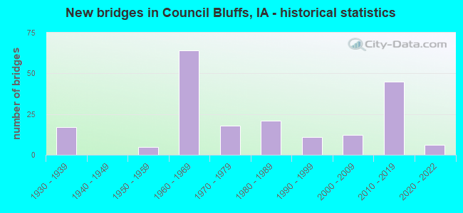
- New bridges - historical statistics
- 171930-1939
- 51950-1959
- 641960-1969
- 181970-1979
- 211980-1989
- 111990-1999
- 122000-2009
- 452010-2019
- 62020-2022
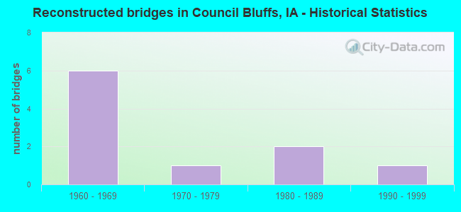
- Reconstructed bridges - Historical Statistics
- 61960-1969
- 11970-1979
- 21980-1989
- 11990-1999
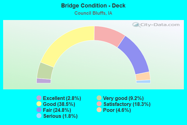
- Bridge Condition - Deck
- 2.8%Excellent
- 9.2%Very good
- 38.5%Good
- 18.3%Satisfactory
- 24.8%Fair
- 4.6%Poor
- 1.8%Serious
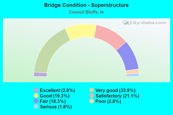
- Bridge Condition - Superstructure
- 2.8%Excellent
- 33.9%Very good
- 19.3%Good
- 21.1%Satisfactory
- 18.3%Fair
- 2.8%Poor
- 1.8%Serious
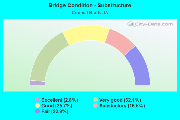
- Bridge Condition - Substructure
- 2.8%Excellent
- 32.1%Very good
- 25.7%Good
- 16.5%Satisfactory
- 22.9%Fair
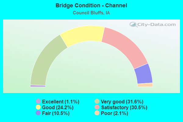
- Bridge Condition - Channel
- 1.1%Excellent
- 31.6%Very good
- 24.2%Good
- 30.5%Satisfactory
- 10.5%Fair
- 2.1%Poor
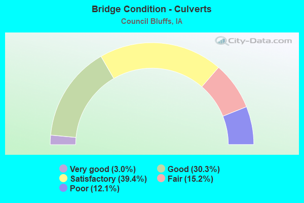
- Bridge Condition - Culverts
- 3.0%Very good
- 30.3%Good
- 39.4%Satisfactory
- 15.2%Fair
- 12.1%Poor
Find on map >> Show street view
Structure Number: 4476, Location: 0.1 MI. S OF JCT. U.S. 6 (Lat: 41.259644, Lng: -95.907033), Route carried "on" structure: Interstate 29, Year Built: 1967, Status: Open, Structure Length: 3.69m (12.11ft), Average Daily Traffic: 6,050 (year 2020), Truck Traffic: 17%, Average Future Daily Traffic: 6,050 (year 2040), Design Load: HS 20, Features Intersected: 2ND AVE
Minimum Vertical Clearance: 30+ m (98+ ft), Kilometerpoint: 86.443, Lanes on structure: 2, Lanes under structure: 2, Base Highway Network: Yes, Owner: State Highway Agency, Approaching Roadway Width: 12.2m (40.0ft), Material/Design: Steel continuous, Design/Construction: Stringer/Multi-beam, Number Of Spans In Main Unit: 3, Length of Maximum Span: 15.9m (52.2ft), Curb or Sidewalk Widths: Left: 0.2m (0.7ft), Right: 0.2m (0.7ft), Curb-To-Curb Width: 13.0m (42.7ft), Out-to-Out Width: 14.0m (45.9ft)
Condition: Deck: Fair, Superstructure: Satisfactory, Substructure: Fair, Operating Rating: 61.1 metric tons, Method Used To Determine Operating Rating: Load Factor (LF), Inventory Rating: 36.8 metric tons, Method Used To Determine Inventory Rating: Load Factor (LF), Structural Evaluation: Somewhat better than minimum adequacy, Deck Geometry: Superior to present desirable criteria, Underclear: Somewhat better than minimum adequacy, Approach Roadway Alignment: Somewhat better than minimum adequacy, Designated Inspection Frequency: Every 24 months, Inspection Date: July 2020, Deck Structure Type: Concrete Cast-file-Place, Wearing Surface/Protective System: Wearing Surface: Monolithic Concrete
Find on map >> Show street view
Structure Number: 4477, Location: 0.1 MI. S OF JCT. US 6 (Lat: 41.259853, Lng: -95.907756), Route carried "on" structure: Interstate 29, Year Built: 1967, Year Reconstructed: 1973, Status: Open, Structure Length: 4.39m (14.40ft), Average Daily Traffic: 6,050 (year 2020), Truck Traffic: 17%, Average Future Daily Traffic: 6,050 (year 2040), Design Load: HS 20, Features Intersected: 2ND AVE
Minimum Vertical Clearance: 30+ m (98+ ft), Kilometerpoint: 158.005, Lanes on structure: 3, Lanes under structure: 2, Owner: State Highway Agency, Approaching Roadway Width: 15.2m (49.9ft), Skew: 2 degrees, Material/Design: Steel continuous, Design/Construction: Stringer/Multi-beam, Number Of Spans In Main Unit: 3, Length of Maximum Span: 17.1m (56.1ft), Curb-To-Curb Width: 15.5m (50.9ft), Out-to-Out Width: 16.9m (55.4ft)
Condition: Deck: Satisfactory, Superstructure: Fair, Substructure: Fair, Operating Rating: 48.1 metric tons, Method Used To Determine Operating Rating: Load Factor (LF), Inventory Rating: 28.8 metric tons, Method Used To Determine Inventory Rating: Load Factor (LF), Structural Evaluation: Somewhat better than minimum adequacy, Deck Geometry: Somewhat better than minimum adequacy, Underclear: Somewhat better than minimum adequacy, Approach Roadway Alignment: Meets minimum limits, Designated Inspection Frequency: Every 24 months, Inspection Date: July 2020, Deck Structure Type: Concrete Cast-file-Place, Wearing Surface/Protective System: Wearing Surface: Low Slump Concrete
Find on map >> Show street view
Structure Number: 4479, Location: AT JCT US 6 & I-480 (Lat: 41.261617, Lng: -95.907339), Route carried "on" structure: Interstate 29, Year Built: 1965, Status: Open, Structure Length: 6.10m (20.01ft), Average Daily Traffic: 6,050 (year 2020), Truck Traffic: 17%, Average Future Daily Traffic: 6,050 (year 2041), Design Load: HS 20, Features Intersected: I 480
Minimum Vertical Clearance: 30+ m (98+ ft), Kilometerpoint: 86.665, Lanes on structure: 2, Lanes under structure: 6, Base Highway Network: Yes, Owner: State Highway Agency, Approaching Roadway Width: 12.2m (40.0ft), Skew: 1 degrees, Material/Design: Steel continuous, Design/Construction: Stringer/Multi-beam, Number Of Spans In Main Unit: 4, Length of Maximum Span: 19.5m (64.0ft), Curb-To-Curb Width: 11.9m (39.0ft), Out-to-Out Width: 12.9m (42.3ft)
Condition: Deck: Fair, Superstructure: Satisfactory, Substructure: Satisfactory, Operating Rating: 44.6 metric tons, Method Used To Determine Operating Rating: Load Factor (LF), Inventory Rating: 26.8 metric tons, Method Used To Determine Inventory Rating: Load Factor (LF), Structural Evaluation: Equal to present minimum criteria, Deck Geometry: Equal to present minimum criteria, Underclear: Meets minimum limits, Approach Roadway Alignment: Equal to present desirable criteria, Designated Inspection Frequency: Every 24 months, Inspection Date: June 2021, Deck Structure Type: Concrete Cast-file-Place, Wearing Surface/Protective System: Wearing Surface: Low Slump Concrete
Find on map >> Show street view
Structure Number: 4481, Location: 0.3 MI. N. OF JCT. US 6 (Lat: 41.267850, Lng: -95.908042), Route carried "on" structure: Interstate 29, Year Built: 1967, Status: Open, Structure Length: 4.15m (13.62ft), Average Daily Traffic: 9,900 (year 2020), Truck Traffic: 13%, Average Future Daily Traffic: 9,900 (year 2040), Design Load: HS 20, Features Intersected: AVE G
Minimum Vertical Clearance: 30+ m (98+ ft), Kilometerpoint: 87.362, Lanes on structure: 2, Lanes under structure: 2, Base Highway Network: Yes, Owner: State Highway Agency, Approaching Roadway Width: 12.2m (40.0ft), Skew: 1 degrees, Material/Design: Steel continuous, Design/Construction: Stringer/Multi-beam, Number Of Spans In Main Unit: 3, Length of Maximum Span: 16.5m (54.1ft), Curb-To-Curb Width: 11.9m (39.0ft), Out-to-Out Width: 12.9m (42.3ft)
Condition: Deck: Fair, Superstructure: Satisfactory, Substructure: Fair, Operating Rating: 44.7 metric tons, Method Used To Determine Operating Rating: Load Factor (LF), Inventory Rating: 26.8 metric tons, Method Used To Determine Inventory Rating: Load Factor (LF), Structural Evaluation: Somewhat better than minimum adequacy, Deck Geometry: Equal to present minimum criteria, Underclear: Meets minimum limits, Approach Roadway Alignment: Somewhat better than minimum adequacy, Designated Inspection Frequency: Every 24 months, Inspection Date: July 2020, Deck Structure Type: Concrete Cast-file-Place, Wearing Surface/Protective System: Wearing Surface: Low Slump Concrete
Find on map >> Show street view
Structure Number: 4482, Location: 0.3 MI. N. OF JCT. U.S. 6 (Lat: 41.268269, Lng: -95.908131), Route carried "on" structure: Interstate 29, Year Built: 1967, Status: Open, Structure Length: 4.15m (13.62ft), Average Daily Traffic: 8,950 (year 2020), Truck Traffic: 15%, Average Future Daily Traffic: 8,950 (year 2040), Design Load: HS 20, Features Intersected: AVE G
Minimum Vertical Clearance: 30+ m (98+ ft), Kilometerpoint: 157.032, Lanes on structure: 3, Lanes under structure: 2, Owner: State Highway Agency, Approaching Roadway Width: 13.1m (43.0ft), Skew: 1 degrees, Material/Design: Steel continuous, Design/Construction: Stringer/Multi-beam, Number Of Spans In Main Unit: 3, Length of Maximum Span: 16.5m (54.1ft), Curb-To-Curb Width: 12.7m (41.7ft), Out-to-Out Width: 14.1m (46.3ft)
Condition: Deck: Fair, Superstructure: Good, Substructure: Fair, Operating Rating: 49.1 metric tons, Method Used To Determine Operating Rating: Load Factor (LF), Inventory Rating: 29.4 metric tons, Method Used To Determine Inventory Rating: Load Factor (LF), Structural Evaluation: Somewhat better than minimum adequacy, Deck Geometry: High priority of replacement, Underclear: Somewhat better than minimum adequacy, Approach Roadway Alignment: Meets minimum limits, Designated Inspection Frequency: Every 24 months, Inspection Date: July 2020, Deck Structure Type: Concrete Cast-file-Place, Wearing Surface/Protective System: Wearing Surface: Low Slump Concrete
Find on map >> Show street view
Structure Number: 4483, Location: 1.0 MI. S OF IA 192 (Lat: 41.274881, Lng: -95.882050), Route carried "on" structure: Interstate 29, Year Built: 1967, Status: Open, Structure Length: 4.82m (15.81ft), Average Daily Traffic: 5,300 (year 2020), Truck Traffic: 20%, Average Future Daily Traffic: 5,300 (year 2041), Design Load: HS 20, Features Intersected: 25TH ST
Minimum Vertical Clearance: 30+ m (98+ ft), Kilometerpoint: 89.776, Lanes on structure: 2, Lanes under structure: 2, Base Highway Network: Yes, Owner: State Highway Agency, Approaching Roadway Width: 12.2m (40.0ft), Material/Design: Prestressed concrete, Design/Construction: Stringer/Multi-beam, Number Of Spans In Main Unit: 3, Length of Maximum Span: 23.5m (77.1ft), Curb-To-Curb Width: 11.9m (39.0ft), Out-to-Out Width: 12.9m (42.3ft)
Condition: Deck: Poor, Superstructure: Very good, Substructure: Good, Operating Rating: 66.4 metric tons, Method Used To Determine Operating Rating: Load Factor (LF), Inventory Rating: 39.9 metric tons, Method Used To Determine Inventory Rating: Load Factor (LF), Structural Evaluation: Better than present minimum criteria, Deck Geometry: Equal to present minimum criteria, Underclear: Equal to present minimum criteria, Approach Roadway Alignment: Better than present minimum criteria, Designated Inspection Frequency: Every 24 months, Other Special Inspection Frequency: Every 3 months, Inspection Date: June 2021, Other Special Inspection Date: December 2021, Deck Structure Type: Concrete Cast-file-Place, Wearing Surface/Protective System: Wearing Surface: Low Slump Concrete
Find on map >> Show street view
Structure Number: 4484, Location: 1.0 MI. S OF IA 192 (Lat: 41.275069, Lng: -95.881469), Route carried "on" structure: Interstate 29, Year Built: 1967, Status: Open, Structure Length: 4.82m (15.81ft), Average Daily Traffic: 5,300 (year 2020), Truck Traffic: 20%, Average Future Daily Traffic: 5,300 (year 2041), Design Load: HS 20, Features Intersected: 25TH ST
Minimum Vertical Clearance: 30+ m (98+ ft), Kilometerpoint: 154.584, Lanes on structure: 2, Lanes under structure: 2, Owner: State Highway Agency, Approaching Roadway Width: 12.2m (40.0ft), Material/Design: Prestressed concrete, Design/Construction: Stringer/Multi-beam, Number Of Spans In Main Unit: 3, Length of Maximum Span: 23.5m (77.1ft), Curb-To-Curb Width: 11.9m (39.0ft), Out-to-Out Width: 12.9m (42.3ft)
Condition: Deck: Poor, Superstructure: Fair, Substructure: Good, Operating Rating: 65.5 metric tons, Method Used To Determine Operating Rating: Load Factor (LF), Inventory Rating: 28.6 metric tons, Method Used To Determine Inventory Rating: Load Factor (LF), Structural Evaluation: Somewhat better than minimum adequacy, Deck Geometry: Equal to present minimum criteria, Underclear: Equal to present minimum criteria, Approach Roadway Alignment: Better than present minimum criteria, Designated Inspection Frequency: Every 24 months, Inspection Date: June 2021, Deck Structure Type: Concrete Cast-file-Place, Wearing Surface/Protective System: Wearing Surface: Low Slump Concrete
Find on map >> Show street view
Structure Number: 4485, Location: 2.1 MI. N OF JCT. US 6 (Lat: 41.275397, Lng: -95.877853), Route carried "on" structure: Interstate 29, Year Built: 1968, Status: Open, Structure Length: 11.52m (37.80ft), Average Daily Traffic: 5,300 (year 2020), Truck Traffic: 20%, Average Future Daily Traffic: 5,300 (year 2041), Design Load: HS 20, Features Intersected: CC&P RR
Minimum Vertical Clearance: 30+ m (98+ ft), Kilometerpoint: 90.138, Lanes on structure: 3, Base Highway Network: Yes, Owner: State Highway Agency, Approaching Roadway Width: 12.2m (40.0ft), Material/Design: Steel continuous, Design/Construction: Stringer/Multi-beam, Number Of Spans In Main Unit: 7, Length of Maximum Span: 18.6m (61.0ft), Curb-To-Curb Width: 13.8m (45.3ft), Out-to-Out Width: 14.9m (48.9ft)
Condition: Deck: Fair, Superstructure: Satisfactory, Substructure: Fair, Operating Rating: 61.2 metric tons, Method Used To Determine Operating Rating: Load Factor (LF), Inventory Rating: 36.7 metric tons, Method Used To Determine Inventory Rating: Load Factor (LF), Structural Evaluation: Somewhat better than minimum adequacy, Deck Geometry: Meets minimum limits, Underclear: Somewhat better than minimum adequacy, Approach Roadway Alignment: Equal to present minimum criteria, Designated Inspection Frequency: Every 24 months, Critical Feature Inspection Frequency: Every 24 months, Inspection Date: October 2021, Critical Feature Inspection Date: October 2021, Deck Structure Type: Concrete Cast-file-Place, Wearing Surface/Protective System: Wearing Surface: Low Slump Concrete
Find on map >> Show street view
Structure Number: 4486, Location: 2.1 MI. N OF JCT. 6 (Lat: 41.276231, Lng: -95.876753), Route carried "on" structure: Interstate 29, Year Built: 1968, Status: Open, Structure Length: 14.26m (46.78ft), Average Daily Traffic: 5,650 (year 2020), Truck Traffic: 20%, Average Future Daily Traffic: 5,650 (year 2041), Design Load: HS 20, Features Intersected: CC RR
Minimum Vertical Clearance: 30+ m (98+ ft), Kilometerpoint: 154.156, Lanes on structure: 2, Owner: State Highway Agency, Approaching Roadway Width: 12.2m (40.0ft), Material/Design: Steel continuous, Design/Construction: Stringer/Multi-beam, Number Of Spans In Main Unit: 7, Length of Maximum Span: 24.1m (79.1ft), Curb-To-Curb Width: 12.3m (40.4ft), Out-to-Out Width: 13.3m (43.6ft)
Condition: Deck: Fair, Superstructure: Satisfactory, Substructure: Fair, Operating Rating: 61.9 metric tons, Method Used To Determine Operating Rating: Load Factor (LF), Inventory Rating: 37.1 metric tons, Method Used To Determine Inventory Rating: Load Factor (LF), Structural Evaluation: Somewhat better than minimum adequacy, Deck Geometry: Better than present minimum criteria, Underclear: Equal to present minimum criteria, Approach Roadway Alignment: Equal to present minimum criteria, Designated Inspection Frequency: Every 24 months, Critical Feature Inspection Frequency: Every 24 months, Inspection Date: October 2021, Critical Feature Inspection Date: October 2021, Deck Structure Type: Concrete Cast-file-Place, Wearing Surface/Protective System: Wearing Surface: Low Slump Concrete
Find on map >> Show street view
Structure Number: 4487, Location: At N jct. of IA 192 (Lat: 41.285217, Lng: -95.867661), Route carried "on" structure: Interstate 29, Year Built: 1967, Status: Open, Structure Length: 6.98m (22.90ft), Average Daily Traffic: 11,300 (year 2020), Truck Traffic: 20%, Average Future Daily Traffic: 11,300 (year 2041), Design Load: HS 20, Features Intersected: SB IA 192
Minimum Vertical Clearance: 30+ m (98+ ft), Kilometerpoint: 91.530, Lanes on structure: 2, Lanes under structure: 2, Base Highway Network: Yes, Owner: State Highway Agency, Approaching Roadway Width: 12.2m (40.0ft), Skew: 5 degrees, Material/Design: Steel continuous, Design/Construction: Stringer/Multi-beam, Number Of Spans In Main Unit: 3, Length of Maximum Span: 26.2m (86.0ft), Curb-To-Curb Width: 11.9m (39.0ft), Out-to-Out Width: 13.0m (42.7ft)
Condition: Deck: Fair, Superstructure: Fair, Substructure: Fair, Operating Rating: 44.6 metric tons, Method Used To Determine Operating Rating: Allowable Stress (AS), Inventory Rating: 21.7 metric tons, Method Used To Determine Inventory Rating: Allowable Stress (AS), Structural Evaluation: Somewhat better than minimum adequacy, Deck Geometry: Equal to present minimum criteria, Underclear: High priority of corrective action, Approach Roadway Alignment: Equal to present minimum criteria, Designated Inspection Frequency: Every 24 months, Inspection Date: August 2021, Deck Structure Type: Concrete Cast-file-Place, Wearing Surface/Protective System: Wearing Surface: Low Slump Concrete
Find on map >> Show street view
Structure Number: 4488, Location: 0.3 mi. N of Jct. IA 192 (Lat: 41.288436, Lng: -95.866147), Route carried "on" structure: Interstate 29, Year Built: 1958, Year Reconstructed: 1969, Status: Open, Structure Length: 0.64m (2.10ft), Average Daily Traffic: 6,600 (year 2020), Truck Traffic: 18%, Average Future Daily Traffic: 6,600 (year 2041), Design Load: H 20, Features Intersected: DRAINAGE DITCH
Minimum Vertical Clearance: 30+ m (98+ ft), Kilometerpoint: 91.918, Lanes on structure: 3, Base Highway Network: Yes, Owner: State Highway Agency, Approaching Roadway Width: 12.2m (40.0ft), Material/Design: Concrete continuous, Design/Construction: Culvert, Number Of Spans In Main Unit: 2, Length of Maximum Span: 3.0m (9.8ft)
Condition: Channel: Good, Culverts: Satisfactory, Operating Rating: 24.5 metric tons, Method Used To Determine Operating Rating: Field evaluation and documented engineering judgment, Inventory Rating: 18.1 metric tons, Method Used To Determine Inventory Rating: Field evaluation and documented engineering judgment, Structural Evaluation: Meets minimum limits, Waterway Adequacy: Equal to present minimum criteria, Approach Roadway Alignment: Better than present minimum criteria, Designated Inspection Frequency: Every 24 months, Inspection Date: May 2021
Find on map >> Show street view
Structure Number: 4489, Location: 0.1 MI. N OF N JCT IA 192 (Lat: 41.288519, Lng: -95.867439), Route carried "on" structure: Interstate 29, Year Built: 1957, Year Reconstructed: 1969, Status: Open, Structure Length: 0.64m (2.10ft), Average Daily Traffic: 6,600 (year 2020), Truck Traffic: 18%, Average Future Daily Traffic: 6,600 (year 2040), Design Load: H 20, Features Intersected: DRAINAGE DITCH
Minimum Vertical Clearance: 30+ m (98+ ft), Kilometerpoint: 152.553, Lanes on structure: 3, Owner: State Highway Agency, Approaching Roadway Width: 15.9m (52.2ft), Material/Design: Concrete continuous, Design/Construction: Culvert, Number Of Spans In Main Unit: 2, Length of Maximum Span: 3.0m (9.8ft)
Condition: Channel: Very good, Culverts: Good, Operating Rating: 24.5 metric tons, Method Used To Determine Operating Rating: Field evaluation and documented engineering judgment, Inventory Rating: 18.1 metric tons, Method Used To Determine Inventory Rating: Field evaluation and documented engineering judgment, Structural Evaluation: Meets minimum limits, Waterway Adequacy: Better than present minimum criteria, Approach Roadway Alignment: Equal to present desirable criteria, Designated Inspection Frequency: Every 24 months, Inspection Date: November 2020
Find on map >> Show street view
Structure Number: 45082, Location: NEBR. STATE LINE (Lat: 41.231611, Lng: -95.910931), Route carried "on" structure: Interstate 80, Year Built: 1972, Status: Open, Structure Length: 75.22m (246.78ft), Average Daily Traffic: 31,150 (year 2020), Truck Traffic: 20%, Average Future Daily Traffic: 31,150 (year 2040), Design Load: HS 20, Features Intersected: MISSOURI RIVER, RD & RR
Minimum Vertical Clearance: 30+ m (98+ ft), Kilometerpoint: 0.000, Lanes on structure: 4, Lanes under structure: 2, Base Highway Network: Yes, Owner: State Highway Agency, Approaching Roadway Width: 24.4m (80.1ft), Skew: 1 degrees, Navigation Control: Yes ( Vertical Clearance: 14.6m (47.9ft), Horizontal Clearance: 121.9m (399.9ft)), Material/Design: Steel continuous, Design/Construction: Girder and Floorbeam System, Number Of Spans In Main Unit: 12, Length of Maximum Span: 129.5m (424.9ft), Curb-To-Curb Width: 23.2m (76.1ft), Out-to-Out Width: 25.1m (82.3ft)
Condition: Deck: Good, Superstructure: Satisfactory, Substructure: Good, Channel: Good, Operating Rating: 38.9 metric tons, Method Used To Determine Operating Rating: Load and Resistance Factor Rating (LRFR) rating reported by rating factor(RF) method using HL-93 loadings, Inventory Rating: 30.1 metric tons, Method Used To Determine Inventory Rating: Load and Resistance Factor Rating (LRFR) rating reported by rating factor(RF) method using HL-93 loadings, Structural Evaluation: Equal to present minimum criteria, Deck Geometry: Superior to present desirable criteria, Underclear: Equal to present minimum criteria, Waterway Adequacy: Superior to present desirable criteria, Approach Roadway Alignment: Equal to present desirable criteria, Designated Inspection Frequency: Every 24 months, Underwater Inspection Frequency: Every 60 months, Inspection Date: August 2020, Underwater Inspection Date: September 2020, Deck Structure Type: Concrete Cast-file-Place, Wearing Surface/Protective System: Wearing Surface: Low Slump Concrete
Find on map >> Show street view
Structure Number: 4517, Location: At Madison Ave. (Lat: 41.241858, Lng: -95.823789), Route carried "on" structure: Interstate 80, Year Built: 1968, Status: Open, Structure Length: 4.69m (15.39ft), Average Daily Traffic: 12,150 (year 2020), Truck Traffic: 34%, Average Future Daily Traffic: 12,150 (year 2041), Design Load: HS 20, Features Intersected: MADISON AVE
Minimum Vertical Clearance: 30+ m (98+ ft), Kilometerpoint: 7.979, Lanes on structure: 2, Lanes under structure: 3, Base Highway Network: Yes, Owner: State Highway Agency, Approaching Roadway Width: 12.2m (40.0ft), Material/Design: Prestressed concrete, Design/Construction: Stringer/Multi-beam, Number Of Spans In Main Unit: 3, Length of Maximum Span: 17.4m (57.1ft), Curb-To-Curb Width: 11.9m (39.0ft), Out-to-Out Width: 13.0m (42.7ft)
Condition: Deck: Fair, Superstructure: Fair, Substructure: Good, Operating Rating: 74.8 metric tons, Method Used To Determine Operating Rating: Load Factor (LF), Inventory Rating: 30.9 metric tons, Method Used To Determine Inventory Rating: Load Factor (LF), Structural Evaluation: Somewhat better than minimum adequacy, Deck Geometry: Equal to present minimum criteria, Underclear: High priority of corrective action, Approach Roadway Alignment: Equal to present minimum criteria, Designated Inspection Frequency: Every 24 months, Inspection Date: May 2021, Deck Structure Type: Concrete Cast-file-Place, Wearing Surface/Protective System: Wearing Surface: Low Slump Concrete
Find on map >> Show street view
Structure Number: 4518, Location: At Madison Ave. (Lat: 41.242328, Lng: -95.823714), Route carried "on" structure: Interstate 80, Year Built: 1968, Status: Open, Structure Length: 4.97m (16.31ft), Average Daily Traffic: 12,150 (year 2020), Truck Traffic: 34%, Average Future Daily Traffic: 12,150 (year 2041), Design Load: HS 20, Features Intersected: MADISON AVE
Minimum Vertical Clearance: 30+ m (98+ ft), Kilometerpoint: 484.388, Lanes on structure: 2, Lanes under structure: 4, Owner: State Highway Agency, Approaching Roadway Width: 12.2m (40.0ft), Material/Design: Prestressed concrete, Design/Construction: Stringer/Multi-beam, Number Of Spans In Main Unit: 3, Length of Maximum Span: 17.4m (57.1ft), Curb-To-Curb Width: 11.9m (39.0ft), Out-to-Out Width: 13.3m (43.6ft)
Condition: Deck: Fair, Superstructure: Good, Substructure: Satisfactory, Operating Rating: 77.7 metric tons, Method Used To Determine Operating Rating: Load Factor (LF), Inventory Rating: 32.6 metric tons, Method Used To Determine Inventory Rating: Load Factor (LF), Structural Evaluation: Equal to present minimum criteria, Deck Geometry: Equal to present minimum criteria, Underclear: High priority of corrective action, Approach Roadway Alignment: Equal to present minimum criteria, Designated Inspection Frequency: Every 24 months, Inspection Date: May 2021, Deck Structure Type: Concrete Cast-file-Place, Wearing Surface/Protective System: Wearing Surface: Low Slump Concrete
Find on map >> Show street view
Structure Number: 4519, Location: 3.2 MI. W OF US 6 (Lat: 41.244236, Lng: -95.820044), Route carried "on" structure: Interstate 80, Year Built: 1968, Status: Open, Structure Length: 18.53m (60.79ft), Average Daily Traffic: 12,150 (year 2020), Truck Traffic: 34%, Average Future Daily Traffic: 12,150 (year 2041), Design Load: HS 20, Features Intersected: BNSF RR,RD & CREEK
Minimum Vertical Clearance: 30+ m (98+ ft), Kilometerpoint: 8.396, Lanes on structure: 3, Lanes under structure: 2, Base Highway Network: Yes, Owner: State Highway Agency, Approaching Roadway Width: 12.2m (40.0ft), Skew: 4 degrees, Material/Design: Steel continuous, Design/Construction: Stringer/Multi-beam, Number Of Spans In Main Unit: 7, Length of Maximum Span: 30.5m (100.1ft), Curb-To-Curb Width: 12.6m (41.3ft), Out-to-Out Width: 13.6m (44.6ft)
Condition: Deck: Fair, Superstructure: Fair, Substructure: Fair, Channel: Good, Operating Rating: 49.0 metric tons, Method Used To Determine Operating Rating: Load Factor (LF), Inventory Rating: 29.4 metric tons, Method Used To Determine Inventory Rating: Load Factor (LF), Structural Evaluation: Somewhat better than minimum adequacy, Deck Geometry: Meets minimum limits, Underclear: Equal to present minimum criteria, Waterway Adequacy: Equal to present desirable criteria, Approach Roadway Alignment: Better than present minimum criteria, Designated Inspection Frequency: Every 24 months, Inspection Date: October 2021, Deck Structure Type: Concrete Cast-file-Place, Wearing Surface/Protective System: Wearing Surface: Low Slump Concrete
Find on map >> Show street view
Structure Number: 452, Location: 3.2 MI. W OF JCT. US 6 (Lat: 41.245192, Lng: -95.818206), Route carried "on" structure: Interstate 80, Year Built: 1968, Status: Open, Structure Length: 18.53m (60.79ft), Average Daily Traffic: 13,050 (year 2020), Truck Traffic: 32%, Average Future Daily Traffic: 13,050 (year 2041), Design Load: HS 20, Features Intersected: BNSF RR,RD & CREEK
Minimum Vertical Clearance: 30+ m (98+ ft), Kilometerpoint: 483.820, Lanes on structure: 3, Lanes under structure: 2, Owner: State Highway Agency, Approaching Roadway Width: 12.2m (40.0ft), Skew: 4 degrees, Material/Design: Steel continuous, Design/Construction: Stringer/Multi-beam, Number Of Spans In Main Unit: 7, Length of Maximum Span: 30.5m (100.1ft), Curb-To-Curb Width: 13.4m (44.0ft), Out-to-Out Width: 14.5m (47.6ft)
Condition: Deck: Satisfactory, Superstructure: Fair, Substructure: Fair, Channel: Good, Operating Rating: 49.3 metric tons, Method Used To Determine Operating Rating: Load Factor (LF), Inventory Rating: 29.6 metric tons, Method Used To Determine Inventory Rating: Load Factor (LF), Structural Evaluation: Somewhat better than minimum adequacy, Deck Geometry: Meets minimum limits, Underclear: Equal to present minimum criteria, Waterway Adequacy: Equal to present desirable criteria, Approach Roadway Alignment: Better than present minimum criteria, Designated Inspection Frequency: Every 24 months, Inspection Date: October 2021, Deck Structure Type: Concrete Cast-file-Place, Wearing Surface/Protective System: Wearing Surface: Low Slump Concrete
Find on map >> Show street view
Structure Number: 4521, Location: 2.3 MI. W OF JCT. US 6 (Lat: 41.253147, Lng: -95.809183), Route carried "on" structure: Interstate 80, Year Built: 1968, Status: Open, Structure Length: 4.88m (16.01ft), Average Daily Traffic: 13,050 (year 2020), Truck Traffic: 32%, Average Future Daily Traffic: 13,050 (year 2041), Design Load: HS 20, Features Intersected: FRANKLIN AVE
Minimum Vertical Clearance: 30+ m (98+ ft), Kilometerpoint: 9.769, Lanes on structure: 2, Lanes under structure: 2, Base Highway Network: Yes, Owner: State Highway Agency, Approaching Roadway Width: 12.2m (40.0ft), Skew: 3 degrees, Material/Design: Steel continuous, Design/Construction: Stringer/Multi-beam, Number Of Spans In Main Unit: 3, Length of Maximum Span: 18.6m (61.0ft), Curb-To-Curb Width: 11.9m (39.0ft), Out-to-Out Width: 13.0m (42.7ft)
Condition: Deck: Fair, Superstructure: Good, Substructure: Satisfactory, Operating Rating: 63.5 metric tons, Method Used To Determine Operating Rating: Load Factor (LF), Inventory Rating: 38.0 metric tons, Method Used To Determine Inventory Rating: Load Factor (LF), Structural Evaluation: Equal to present minimum criteria, Deck Geometry: Equal to present minimum criteria, Underclear: High priority of corrective action, Approach Roadway Alignment: Equal to present desirable criteria, Designated Inspection Frequency: Every 24 months, Inspection Date: May 2021, Deck Structure Type: Concrete Cast-file-Place, Wearing Surface/Protective System: Wearing Surface: Low Slump Concrete
Find on map >> Show street view
Structure Number: 4525, Location: 1.6 mi. W of Jct. U.S. 6 (Lat: 41.261644, Lng: -95.802358), Route carried "on" structure: Interstate 80, Year Built: 1966, Status: Open, Structure Length: 1.22m (4.00ft), Average Daily Traffic: 26,100 (year 2020), Truck Traffic: 32%, Average Future Daily Traffic: 26,100 (year 2041), Design Load: H 20, Features Intersected: LITTLE MOSQUITO CREEK
Minimum Vertical Clearance: 30+ m (98+ ft), Kilometerpoint: 10.871, Lanes on structure: 4, Base Highway Network: Yes, Owner: State Highway Agency, Approaching Roadway Width: 24.4m (80.1ft), Skew: 22 degrees, Material/Design: Concrete continuous, Design/Construction: Culvert, Number Of Spans In Main Unit: 3, Length of Maximum Span: 4.0m (13.1ft)
Condition: Channel: Satisfactory, Culverts: Satisfactory, Operating Rating: 24.5 metric tons, Method Used To Determine Operating Rating: Field evaluation and documented engineering judgment, Inventory Rating: 18.1 metric tons, Method Used To Determine Inventory Rating: Field evaluation and documented engineering judgment, Structural Evaluation: Meets minimum limits, Waterway Adequacy: Equal to present minimum criteria, Approach Roadway Alignment: Better than present minimum criteria, Designated Inspection Frequency: Every 24 months, Inspection Date: January 2021
Find on map >> Show street view
Structure Number: 4526, Location: AT JCT US 6 (Lat: 41.279739, Lng: -95.784633), Route carried "on" structure: Interstate 80, Year Built: 1967, Status: Open, Structure Length: 7.47m (24.51ft), Average Daily Traffic: 9,800 (year 2020), Truck Traffic: 40%, Average Future Daily Traffic: 9,800 (year 2041), Design Load: HS 20, Features Intersected: US 6
Minimum Vertical Clearance: 30+ m (98+ ft), Kilometerpoint: 13.395, Lanes on structure: 2, Lanes under structure: 4, Base Highway Network: Yes, Owner: State Highway Agency, Approaching Roadway Width: 12.2m (40.0ft), Skew: 2 degrees, Material/Design: Steel continuous, Design/Construction: Stringer/Multi-beam, Number Of Spans In Main Unit: 4, Length of Maximum Span: 21.3m (69.9ft), Curb-To-Curb Width: 11.9m (39.0ft), Out-to-Out Width: 12.9m (42.3ft)
Condition: Deck: Good, Superstructure: Satisfactory, Substructure: Good, Operating Rating: 48.7 metric tons, Method Used To Determine Operating Rating: Allowable Stress (AS), Inventory Rating: 31.5 metric tons, Method Used To Determine Inventory Rating: Allowable Stress (AS), Structural Evaluation: Equal to present minimum criteria, Deck Geometry: Equal to present minimum criteria, Underclear: Meets minimum limits, Approach Roadway Alignment: Better than present minimum criteria, Designated Inspection Frequency: Every 24 months, Inspection Date: May 2021, Deck Structure Type: Concrete Cast-file-Place, Wearing Surface/Protective System: Wearing Surface: Low Slump Concrete
Find on map >> Show street view
Structure Number: 4527, Location: AT JCT US 6 (Lat: 41.280436, Lng: -95.784500), Route carried "on" structure: Interstate 80, Year Built: 1967, Status: Open, Structure Length: 7.47m (24.51ft), Average Daily Traffic: 9,800 (year 2020), Truck Traffic: 40%, Average Future Daily Traffic: 9,800 (year 2041), Design Load: HS 20, Features Intersected: US 6
Minimum Vertical Clearance: 30+ m (98+ ft), Kilometerpoint: 478.947, Lanes on structure: 2, Lanes under structure: 4, Owner: State Highway Agency, Approaching Roadway Width: 12.2m (40.0ft), Skew: 2 degrees, Material/Design: Steel continuous, Design/Construction: Stringer/Multi-beam, Number Of Spans In Main Unit: 4, Length of Maximum Span: 21.3m (69.9ft), Curb-To-Curb Width: 11.9m (39.0ft), Out-to-Out Width: 12.9m (42.3ft)
Condition: Deck: Good, Superstructure: Satisfactory, Substructure: Satisfactory, Operating Rating: 48.1 metric tons, Method Used To Determine Operating Rating: Allowable Stress (AS), Inventory Rating: 31.1 metric tons, Method Used To Determine Inventory Rating: Allowable Stress (AS), Structural Evaluation: Equal to present minimum criteria, Deck Geometry: Equal to present minimum criteria, Underclear: Meets minimum limits, Approach Roadway Alignment: Better than present minimum criteria, Designated Inspection Frequency: Every 24 months, Inspection Date: May 2021, Deck Structure Type: Concrete Cast-file-Place, Wearing Surface/Protective System: Wearing Surface: Low Slump Concrete
Find on map >> Show street view
Structure Number: 4567, Location: OVER MISSOURI RIVER (Lat: 41.259694, Lng: -95.921114), Route carried "on" structure: Interstate 480, Year Built: 1966, Status: Open, Structure Length: 51.42m (168.70ft), Average Daily Traffic: 47,200 (year 2020), Truck Traffic: 7%, Average Future Daily Traffic: 47,200 (year 2040), Design Load: HS 20, Features Intersected: MISSOURI RIVER & RR
Minimum Vertical Clearance: 30+ m (98+ ft), Kilometerpoint: 0.000, Lanes on structure: 8, Lanes under structure: 2, Base Highway Network: Yes, Owner: State Highway Agency, Approaching Roadway Width: 32.6m (107.0ft), Skew: 30 degrees, Navigation Control: Yes ( Vertical Clearance: 16.2m (53.1ft), Horizontal Clearance: 121.9m (399.9ft)), Material/Design: Steel continuous, Design/Construction: Girder and Floorbeam System, Number Of Spans In Main Unit: 8, Length of Maximum Span: 129.5m (424.9ft), Curb or Sidewalk Widths: Left: 0.9m (3.0ft), Right: 0.9m (3.0ft), Curb-To-Curb Width: 33.4m (109.6ft), Out-to-Out Width: 35.1m (115.2ft)
Condition: Deck: Good, Superstructure: Satisfactory, Substructure: Fair, Channel: Good, Operating Rating: 26.3 metric tons, Method Used To Determine Operating Rating: Load Factor (LF), Inventory Rating: 15.4 metric tons, Method Used To Determine Inventory Rating: Load Factor (LF), Structural Evaluation: High priority of corrective action, Deck Geometry: Meets minimum limits, Underclear: Somewhat better than minimum adequacy, Waterway Adequacy: Equal to present desirable criteria, Approach Roadway Alignment: Equal to present desirable criteria, Designated Inspection Frequency: Every 24 months, Critical Feature Inspection Frequency: Every 24 months, Underwater Inspection Frequency: Every 60 months, Inspection Date: September 2020, Critical Feature Inspection Date: September 2020, Underwater Inspection Date: October 2018, Deck Structure Type: Concrete Cast-file-Place, Wearing Surface/Protective System: Wearing Surface: Low Slump Concrete
Find on map >> Show street view
Structure Number: 4568, Location: 0.4 MI. E OF NE ST. LINE (Lat: 41.261231, Lng: -95.914150), Route carried "on" structure: Interstate 480, Year Built: 1965, Status: Open, Structure Length: 4.51m (14.80ft), Average Daily Traffic: 9,200 (year 2020), Truck Traffic: 2%, Average Future Daily Traffic: 9,200 (year 2041), Design Load: HS 20, Features Intersected: 41ST STREET
Minimum Vertical Clearance: 30+ m (98+ ft), Kilometerpoint: 0.806, Lanes on structure: 4, Lanes under structure: 2, Owner: State Highway Agency, Approaching Roadway Width: 19.5m (64.0ft), Skew: 2 degrees, Material/Design: Steel continuous, Design/Construction: Stringer/Multi-beam, Number Of Spans In Main Unit: 3, Length of Maximum Span: 18.3m (60.0ft), Curb-To-Curb Width: 16.6m (54.5ft), Out-to-Out Width: 18.3m (60.0ft)
Condition: Deck: Fair, Superstructure: Fair, Substructure: Satisfactory, Operating Rating: 58.1 metric tons, Method Used To Determine Operating Rating: Load Factor (LF), Inventory Rating: 34.8 metric tons, Method Used To Determine Inventory Rating: Load Factor (LF), Structural Evaluation: Somewhat better than minimum adequacy, Deck Geometry: High priority of replacement, Underclear: Somewhat better than minimum adequacy, Approach Roadway Alignment: Equal to present minimum criteria, Designated Inspection Frequency: Every 24 months, Inspection Date: July 2021, Deck Structure Type: Concrete Cast-file-Place, Wearing Surface/Protective System: Wearing Surface: Low Slump Concrete
Find on map >> Show street view
Structure Number: 24716, Location: 073431401 (Lat: 41.130683, Lng: -95.758292), Route carried "on" structure: County highway , Year Built: 1969, Status: Open, Structure Length: 0.73m (2.40ft), Average Daily Traffic: 1,530 (year 2016), Truck Traffic: 6%, Average Future Daily Traffic: 1,530 (year 2041), Design Load: H 20, Features Intersected: PONY CREEK, Facility Carried by Structure: FA-BARRUS RD
Minimum Vertical Clearance: 30+ m (98+ ft), Kilometerpoint: 3.795, Lanes on structure: 2, Owner: County Highway Agency, Approaching Roadway Width: 9.4m (30.8ft), Material/Design: Concrete continuous, Design/Construction: Culvert, Number Of Spans In Main Unit: 2, Length of Maximum Span: 3.4m (11.2ft)
Condition: Channel: Fair, Culverts: Poor, Operating Rating: 44.4 metric tons, Method Used To Determine Operating Rating: Field evaluation and documented engineering judgment, Inventory Rating: 32.7 metric tons, Method Used To Determine Inventory Rating: Field evaluation and documented engineering judgment, Structural Evaluation: Meets minimum limits, Waterway Adequacy: Meets minimum limits, Approach Roadway Alignment: Equal to present desirable criteria, Length Of Structure Improvement: 2.30m (7.55ft), Designated Inspection Frequency: Every 24 months, Inspection Date: Febuary 2021, Bridge Improvement Cost: $10,000, Roadway Improvement Cost: $1,000
Find on map >> Show street view
Structure Number: 284831, Location: 074430203 (Lat: 41.239878, Lng: -95.759581), Route carried "on" structure: County highway , Year Built: 1978, Status: Open, Structure Length: 0.82m (2.69ft), Average Daily Traffic: 1,260 (year 2016), Truck Traffic: 21%, Average Future Daily Traffic: 1,260 (year 2041), Design Load: HS 20, Features Intersected: STREAM, Facility Carried by Structure: GREENVIEW ROAD
Minimum Vertical Clearance: 30+ m (98+ ft), Kilometerpoint: 4.031, Lanes on structure: 2, Owner: County Highway Agency, Approaching Roadway Width: 8.5m (27.9ft), Skew: 3 degrees, Material/Design: Steel, Design/Construction: Culvert, Number Of Spans In Main Unit: 1, Length of Maximum Span: 8.2m (26.9ft)
Condition: Channel: Fair, Culverts: Good, Operating Rating: 44.4 metric tons, Method Used To Determine Operating Rating: Field evaluation and documented engineering judgment, Inventory Rating: 32.7 metric tons, Method Used To Determine Inventory Rating: Field evaluation and documented engineering judgment, Structural Evaluation: Better than present minimum criteria, Waterway Adequacy: Equal to present desirable criteria, Approach Roadway Alignment: Equal to present desirable criteria, Designated Inspection Frequency: Every 24 months, Inspection Date: June 2021
Find on map >> Show street view
Structure Number: 284881, Location: 074431202 (Lat: 41.227428, Lng: -95.746386), Route carried "on" structure: County highway , Year Built: 1998, Status: Open, Structure Length: 1.19m (3.90ft), Average Daily Traffic: 230 (year 2016), Truck Traffic: 9%, Average Future Daily Traffic: 230 (year 2040), Design Load: HS 20, Features Intersected: PONY CREEK, Facility Carried by Structure: LOCAL ROAD
Minimum Vertical Clearance: 30+ m (98+ ft), Kilometerpoint: 1.020, Lanes on structure: 2, Owner: County Highway Agency, Approaching Roadway Width: 9.4m (30.8ft), Skew: 1 degrees, Material/Design: Prestressed concrete, Design/Construction: Tee Beam, Number Of Spans In Main Unit: 1, Length of Maximum Span: 11.3m (37.1ft), Curb-To-Curb Width: 8.1m (26.6ft), Out-to-Out Width: 8.6m (28.2ft)
Condition: Deck: Very good, Superstructure: Good, Substructure: Very good, Channel: Satisfactory, Operating Rating: 83.1 metric tons, Method Used To Determine Operating Rating: Load Factor (LF), Inventory Rating: 49.8 metric tons, Method Used To Determine Inventory Rating: Load Factor (LF), Structural Evaluation: Better than present minimum criteria, Deck Geometry: Somewhat better than minimum adequacy, Waterway Adequacy: Better than present minimum criteria, Approach Roadway Alignment: Equal to present desirable criteria, Designated Inspection Frequency: Every 48 months, Inspection Date: May 2020, Deck Structure Type: Concrete Cast-file-Place, Wearing Surface/Protective System: Wearing Surface: Bituminous
Find on map >> Show street view
Structure Number: 2849, Location: 074431503 (Lat: 41.215569, Lng: -95.780422), Route carried "on" structure: County highway , Year Built: 1966, Status: Open, Structure Length: 6.10m (20.01ft), Average Daily Traffic: 1,740 (year 2016), Truck Traffic: 11%, Average Future Daily Traffic: 1,740 (year 2040), Design Load: HS 20, Features Intersected: PONY CREEK, Facility Carried by Structure: FM
Minimum Vertical Clearance: 30+ m (98+ ft), Kilometerpoint: 1.096, Lanes on structure: 2, Owner: County Highway Agency, Approaching Roadway Width: 10.1m (33.1ft), Skew: 4 degrees, Material/Design: Steel continuous, Design/Construction: Stringer/Multi-beam, Number Of Spans In Main Unit: 3, Length of Maximum Span: 23.8m (78.1ft), Curb-To-Curb Width: 8.5m (27.9ft), Out-to-Out Width: 9.0m (29.5ft)
Condition: Deck: Satisfactory, Superstructure: Fair, Substructure: Fair, Channel: Satisfactory, Operating Rating: 40.4 metric tons, Method Used To Determine Operating Rating: Load Factor (LF), Inventory Rating: 24.2 metric tons, Method Used To Determine Inventory Rating: Load Factor (LF), Structural Evaluation: Somewhat better than minimum adequacy, Deck Geometry: Somewhat better than minimum adequacy, Waterway Adequacy: Equal to present desirable criteria, Approach Roadway Alignment: Equal to present desirable criteria, Designated Inspection Frequency: Every 24 months, Inspection Date: May 2020, Deck Structure Type: Concrete Cast-file-Place, Wearing Surface/Protective System: Wearing Surface: Monolithic Concrete
Find on map >> Show street view
Structure Number: 284991, Location: 074432904 (Lat: 41.181647, Lng: -95.814869), Route carried "on" structure: County highway , Year Built: 1981, Status: Open, Structure Length: 4.33m (14.21ft), Average Daily Traffic: 100 (year 2019), Truck Traffic: 26%, Average Future Daily Traffic: 100 (year 2040), Design Load: HS 20, Features Intersected: PONY CREEK, Facility Carried by Structure: FM
Minimum Vertical Clearance: 30+ m (98+ ft), Kilometerpoint: 3.991, Lanes on structure: 2, Owner: County Highway Agency, Approaching Roadway Width: 9.8m (32.2ft), Material/Design: Prestressed concrete continuous, Design/Construction: Stringer/Multi-beam, Number Of Spans In Main Unit: 3, Length of Maximum Span: 15.9m (52.2ft), Curb-To-Curb Width: 9.1m (29.9ft), Out-to-Out Width: 10.1m (33.1ft)
Condition: Deck: Good, Superstructure: Very good, Substructure: Very good, Channel: Good, Operating Rating: 70.2 metric tons, Method Used To Determine Operating Rating: Allowable Stress (AS), Inventory Rating: 35.6 metric tons, Method Used To Determine Inventory Rating: Allowable Stress (AS), Structural Evaluation: Equal to present desirable criteria, Deck Geometry: Better than present minimum criteria, Waterway Adequacy: Equal to present desirable criteria, Approach Roadway Alignment: Equal to present desirable criteria, Designated Inspection Frequency: Every 48 months, Inspection Date: May 2020, Deck Structure Type: Concrete Cast-file-Place, Wearing Surface/Protective System: Wearing Surface: Monolithic Concrete
Find on map >> Show street view
Structure Number: 286781, Location: 075430809 (Lat: 41.312031, Lng: -95.812944), Route carried "on" structure: County highway , Year Built: 1991, Status: Posted for load, Structure Length: 1.95m (6.40ft), Average Daily Traffic: 70 (year 2016), Average Future Daily Traffic: 70 (year 2040), Design Load: HS 20, Features Intersected: STREAM, Facility Carried by Structure: HUDSON AVE
Minimum Vertical Clearance: 30+ m (98+ ft), Kilometerpoint: 0.042, Lanes on structure: 2, Owner: County Highway Agency, Approaching Roadway Width: 8.5m (27.9ft), Skew: 1 degrees, Material/Design: Steel, Design/Construction: Stringer/Multi-beam, Number Of Spans In Main Unit: 1, Number Of Approach Spans: 1, Length of Maximum Span: 12.5m (41.0ft), Curb-To-Curb Width: 5.5m (18.0ft), Out-to-Out Width: 5.5m (18.0ft)
Condition: Deck: Satisfactory, Superstructure: Fair, Substructure: Satisfactory, Channel: Satisfactory, Operating Rating: 11.4 metric tons, Method Used To Determine Operating Rating: Allowable Stress (AS), Inventory Rating: 6.9 metric tons, Method Used To Determine Inventory Rating: Allowable Stress (AS), Structural Evaluation: High priority of corrective action, Deck Geometry: Meets minimum limits, Waterway Adequacy: Equal to present desirable criteria, Approach Roadway Alignment: Better than present minimum criteria, Bridge Posting: Required (Relationship of Operating Rating to Maximum Legal Load: > 39.9% below), Designated Inspection Frequency: Every 24 months, Inspection Date: May 2020, Deck Structure Type: Wood or Timber, Wearing Surface/Protective System: Wearing Surface: Wood or Timber
Find on map >> Show street view
Structure Number: 286881, Location: 075431803 (Lat: 41.299739, Lng: -95.831167), Route carried "on" structure: County highway , Year Built: 1980, Status: Open, Structure Length: 0.76m (2.49ft), Average Daily Traffic: 200 (year 2016), Average Future Daily Traffic: 200 (year 2041), Features Intersected: INDIAN CREEK, Facility Carried by Structure: SCHOOL HILL AVE
Minimum Vertical Clearance: 30+ m (98+ ft), Kilometerpoint: 0.544, Lanes on structure: 2, Owner: County Highway Agency, Approaching Roadway Width: 9.8m (32.2ft), Material/Design: Steel, Design/Construction: Culvert, Number Of Spans In Main Unit: 1, Length of Maximum Span: 7.6m (24.9ft), Curb-To-Curb Width: 9.8m (32.2ft), Out-to-Out Width: 9.8m (32.2ft)
Condition: Channel: Fair, Culverts: Satisfactory, Operating Rating: 44.4 metric tons, Method Used To Determine Operating Rating: Allowable Stress (AS), Inventory Rating: 32.7 metric tons, Method Used To Determine Inventory Rating: Allowable Stress (AS), Structural Evaluation: Equal to present minimum criteria, Deck Geometry: Better than present minimum criteria, Waterway Adequacy: Equal to present desirable criteria, Approach Roadway Alignment: Equal to present desirable criteria, Length Of Structure Improvement: 2.50m (8.20ft), Designated Inspection Frequency: Every 24 months, Inspection Date: May 2021, Bridge Improvement Cost: $25,000, Roadway Improvement Cost: $25,000
Find on map >> Show street view
Structure Number: 286891, Location: 075431814 (Lat: 41.303767, Lng: -95.828247), Route carried "on" structure: County highway , Year Built: 1980, Status: Open, Structure Length: 0.94m (3.08ft), Average Daily Traffic: 430 (year 2016), Average Future Daily Traffic: 430 (year 2041), Features Intersected: INDIAN CREEK, Facility Carried by Structure: MUDHOLLOW ROAD
Minimum Vertical Clearance: 30+ m (98+ ft), Kilometerpoint: 1.313, Lanes on structure: 2, Owner: County Highway Agency, Approaching Roadway Width: 12.2m (40.0ft), Skew: 4 degrees, Material/Design: Steel, Design/Construction: Culvert, Number Of Spans In Main Unit: 1, Length of Maximum Span: 9.4m (30.8ft)
Condition: Channel: Poor, Culverts: Fair, Operating Rating: 44.4 metric tons, Method Used To Determine Operating Rating: Allowable Stress (AS), Inventory Rating: 32.7 metric tons, Method Used To Determine Inventory Rating: Allowable Stress (AS), Structural Evaluation: Somewhat better than minimum adequacy, Waterway Adequacy: Equal to present desirable criteria, Approach Roadway Alignment: Equal to present desirable criteria, Length Of Structure Improvement: 3.10m (10.17ft), Designated Inspection Frequency: Every 24 months, Inspection Date: May 2021, Bridge Improvement Cost: $25,000, Roadway Improvement Cost: $25,000
Find on map >> Show street view
Structure Number: 286901, Location: 075431811 (Lat: 41.294625, Lng: -95.832522), Route carried "on" structure: County highway , Year Built: 1976, Status: Open, Structure Length: 0.73m (2.40ft), Average Daily Traffic: 960 (year 2016), Average Future Daily Traffic: 960 (year 2040), Design Load: H 20, Features Intersected: INDIAN CREEK, Facility Carried by Structure: CATHY LANE
Minimum Vertical Clearance: 30+ m (98+ ft), Kilometerpoint: 0.016, Lanes on structure: 2, Owner: County Highway Agency, Approaching Roadway Width: 7.9m (25.9ft), Skew: 1 degrees, Material/Design: Steel, Design/Construction: Culvert, Number Of Spans In Main Unit: 1, Length of Maximum Span: 7.3m (24.0ft)
Condition: Channel: Satisfactory, Culverts: Good, Operating Rating: 44.4 metric tons, Method Used To Determine Operating Rating: Field evaluation and documented engineering judgment, Inventory Rating: 32.7 metric tons, Method Used To Determine Inventory Rating: Field evaluation and documented engineering judgment, Structural Evaluation: Better than present minimum criteria, Waterway Adequacy: Equal to present desirable criteria, Approach Roadway Alignment: Equal to present desirable criteria, Designated Inspection Frequency: Every 24 months, Inspection Date: May 2020
Find on map >> Show street view
Structure Number: 28693, Location: 075431824 (Lat: 41.295464, Lng: -95.832169), Route carried "on" structure: County highway , Year Built: 1976, Status: Open, Structure Length: 1.01m (3.31ft), Average Daily Traffic: 620 (year 2016), Truck Traffic: 11%, Average Future Daily Traffic: 620 (year 2040), Design Load: H 20, Features Intersected: INDIAN CREEK, Facility Carried by Structure: FM-MUDHOLLOW RD
Minimum Vertical Clearance: 30+ m (98+ ft), Kilometerpoint: 0.317, Lanes on structure: 2, Owner: County Highway Agency, Approaching Roadway Width: 9.1m (29.9ft), Skew: 4 degrees, Material/Design: Steel, Design/Construction: Culvert, Number Of Spans In Main Unit: 1, Length of Maximum Span: 10.1m (33.1ft)
Condition: Channel: Satisfactory, Culverts: Good, Operating Rating: 44.4 metric tons, Method Used To Determine Operating Rating: Field evaluation and documented engineering judgment, Inventory Rating: 32.7 metric tons, Method Used To Determine Inventory Rating: Field evaluation and documented engineering judgment, Structural Evaluation: Better than present minimum criteria, Waterway Adequacy: Equal to present desirable criteria, Approach Roadway Alignment: Equal to present desirable criteria, Designated Inspection Frequency: Every 24 months, Inspection Date: May 2020
Find on map >> Show street view
Structure Number: 286941, Location: 075431828 (Lat: 41.293833, Lng: -95.833675), Route carried "on" structure: County highway , Year Built: 1976, Status: Open, Structure Length: 0.70m (2.30ft), Average Daily Traffic: 1,030 (year 2016), Truck Traffic: 10%, Average Future Daily Traffic: 1,030 (year 2040), Design Load: H 20, Features Intersected: INDIAN CREEK, Facility Carried by Structure: FM-MUDHOLLOW RD
Minimum Vertical Clearance: 30+ m (98+ ft), Kilometerpoint: 0.095, Lanes on structure: 2, Owner: County Highway Agency, Approaching Roadway Width: 9.1m (29.9ft), Material/Design: Steel, Design/Construction: Culvert, Number Of Spans In Main Unit: 1, Length of Maximum Span: 7.0m (23.0ft)
Condition: Channel: Satisfactory, Culverts: Good, Operating Rating: 44.4 metric tons, Method Used To Determine Operating Rating: Field evaluation and documented engineering judgment, Inventory Rating: 32.7 metric tons, Method Used To Determine Inventory Rating: Field evaluation and documented engineering judgment, Structural Evaluation: Better than present minimum criteria, Waterway Adequacy: Equal to present desirable criteria, Approach Roadway Alignment: Equal to present desirable criteria, Designated Inspection Frequency: Every 24 months, Inspection Date: May 2020
Find on map >> Show street view
Structure Number: 287071, Location: 075432804 (Lat: 41.261336, Lng: -95.795450), Route carried "on" structure: County highway , Year Built: 1973, Status: Open, Structure Length: 2.77m (9.09ft), Average Daily Traffic: 1,050 (year 2016), Truck Traffic: 10%, Average Future Daily Traffic: 1,050 (year 2040), Design Load: HS 20, Features Intersected: LITTLE MOSQUITO, Facility Carried by Structure: ORCHARD ROAD
Minimum Vertical Clearance: 30+ m (98+ ft), Kilometerpoint: 2.047, Lanes on structure: 2, Owner: County Highway Agency, Approaching Roadway Width: 9.1m (29.9ft), Material/Design: Concrete continuous, Design/Construction: Slab, Number Of Spans In Main Unit: 3, Length of Maximum Span: 10.4m (34.1ft), Curb-To-Curb Width: 9.1m (29.9ft), Out-to-Out Width: 9.8m (32.2ft)
Condition: Deck: Fair, Superstructure: Satisfactory, Substructure: Satisfactory, Channel: Poor, Operating Rating: 48.5 metric tons, Method Used To Determine Operating Rating: Allowable Stress (AS), Inventory Rating: 30.4 metric tons, Method Used To Determine Inventory Rating: Allowable Stress (AS), Structural Evaluation: Equal to present minimum criteria, Deck Geometry: Somewhat better than minimum adequacy, Waterway Adequacy: Equal to present desirable criteria, Approach Roadway Alignment: Equal to present desirable criteria, Designated Inspection Frequency: Every 24 months, Inspection Date: May 2020, Deck Structure Type: Concrete Cast-file-Place, Wearing Surface/Protective System: Wearing Surface: Monolithic Concrete
Find on map >> Show street view
Structure Number: 287081, Location: 075432809 (Lat: 41.266508, Lng: -95.786453), Route carried "on" structure: County highway , Year Built: 1987, Status: Open, Structure Length: 0.98m (3.22ft), Average Daily Traffic: 700 (year 2016), Truck Traffic: 7%, Average Future Daily Traffic: 700 (year 2040), Design Load: H 20, Features Intersected: LITTLE MOSQUITO, Facility Carried by Structure: FM-MCPHERSON AV
Minimum Vertical Clearance: 30+ m (98+ ft), Kilometerpoint: 1.213, Lanes on structure: 2, Owner: County Highway Agency, Approaching Roadway Width: 12.2m (40.0ft), Skew: 4 degrees, Material/Design: Steel, Design/Construction: Culvert, Number Of Spans In Main Unit: 1, Length of Maximum Span: 9.8m (32.2ft)
Condition: Channel: Satisfactory, Culverts: Satisfactory, Operating Rating: 44.4 metric tons, Method Used To Determine Operating Rating: Field evaluation and documented engineering judgment, Inventory Rating: 32.7 metric tons, Method Used To Determine Inventory Rating: Field evaluation and documented engineering judgment, Structural Evaluation: Equal to present minimum criteria, Waterway Adequacy: Equal to present desirable criteria, Approach Roadway Alignment: Equal to present desirable criteria, Designated Inspection Frequency: Every 24 months, Inspection Date: May 2020
Find on map >> Show street view
Structure Number: 287086, Location: 000000000 (Lat: 41.261278, Lng: -95.798669), Route carried "on" structure: County highway , Year Built: 1989, Status: Open, Structure Length: 1.65m (5.41ft), Average Daily Traffic: 2,700 (year 2016), Average Future Daily Traffic: 2,700 (year 2041), Design Load: HS 20, Features Intersected: LITTLE MOSQUITO CREEK, Facility Carried by Structure: MCPHERSON AVE
Minimum Vertical Clearance: 30+ m (98+ ft), Kilometerpoint: 0.008, Lanes on structure: 2, Owner: City or Municipal Highway Agency, Approaching Roadway Width: 12.2m (40.0ft), Skew: 4 degrees, Material/Design: Concrete continuous, Design/Construction: Culvert, Number Of Spans In Main Unit: 3, Length of Maximum Span: 5.5m (18.0ft)
Condition: Channel: Satisfactory, Culverts: Satisfactory, Operating Rating: 56.4 metric tons, Method Used To Determine Operating Rating: Load Factor (LF), Inventory Rating: 33.7 metric tons, Method Used To Determine Inventory Rating: Load Factor (LF), Structural Evaluation: Equal to present minimum criteria, Waterway Adequacy: Equal to present desirable criteria, Approach Roadway Alignment: Equal to present desirable criteria, Designated Inspection Frequency: Every 24 months, Inspection Date: July 2021
Find on map >> Show street view
Structure Number: 363835, Location: 073430806 (Lat: 41.143114, Lng: -95.815231), Route carried "on" structure: County highway , Year Built: 1995, Status: Open, Structure Length: 0.67m (2.20ft), Average Daily Traffic: 1,250 (year 2019), Truck Traffic: 17%, Average Future Daily Traffic: 1,250 (year 2041), Design Load: HS 20, Features Intersected: ST MARY'S DITCH, Facility Carried by Structure: FM-195TH ST
Minimum Vertical Clearance: 30+ m (98+ ft), Kilometerpoint: 26.514, Lanes on structure: 2, Owner: County Highway Agency, Approaching Roadway Width: 9.4m (30.8ft), Skew: 4 degrees, Material/Design: Concrete continuous, Design/Construction: Culvert, Number Of Spans In Main Unit: 2, Length of Maximum Span: 4.6m (15.1ft)
Condition: Channel: Good, Culverts: Good, Operating Rating: 44.4 metric tons, Method Used To Determine Operating Rating: Field evaluation and documented engineering judgment, Inventory Rating: 32.7 metric tons, Method Used To Determine Inventory Rating: Field evaluation and documented engineering judgment, Structural Evaluation: Better than present minimum criteria, Waterway Adequacy: Equal to present desirable criteria, Approach Roadway Alignment: Equal to present desirable criteria, Designated Inspection Frequency: Every 24 months, Inspection Date: Febuary 2021
Find on map >> Show street view
Structure Number: 36443, Location: 074433304 (Lat: 41.162928, Lng: -95.800456), Route carried "on" structure: County highway , Year Built: 1997, Status: Open, Structure Length: 0.76m (2.49ft), Average Daily Traffic: 10 (year 2019), Truck Traffic: 8%, Average Future Daily Traffic: 5,300 (year 2040), Design Load: HS 20, Features Intersected: DRAINAGE, Facility Carried by Structure: FIELD ENTRANCE
Minimum Vertical Clearance: 30+ m (98+ ft), Kilometerpoint: 0.336, Lanes on structure: 2, Owner: County Highway Agency, Approaching Roadway Width: 9.8m (32.2ft), Material/Design: Wood or Timber, Design/Construction: Stringer/Multi-beam, Number Of Spans In Main Unit: 1, Length of Maximum Span: 7.3m (24.0ft), Curb-To-Curb Width: 7.2m (23.6ft), Out-to-Out Width: 7.4m (24.3ft)
Condition: Deck: Satisfactory, Superstructure: Good, Substructure: Good, Channel: Fair, Operating Rating: 36.0 metric tons, Method Used To Determine Operating Rating: Allowable Stress (AS), Inventory Rating: 25.6 metric tons, Method Used To Determine Inventory Rating: Allowable Stress (AS), Structural Evaluation: Equal to present minimum criteria, Deck Geometry: Somewhat better than minimum adequacy, Waterway Adequacy: Better than present minimum criteria, Approach Roadway Alignment: Equal to present minimum criteria, Designated Inspection Frequency: Every 24 months, Inspection Date: May 2020, Deck Structure Type: Wood or Timber, Wearing Surface/Protective System: Wearing Surface: Wood or Timber
Find on map >> Show street view
Structure Number: 50023, Location: 1.1 MI. N OF I-80 (Lat: 41.253528, Lng: -95.853992), Route carried "on" structure: City street , Year Built: 1976, Status: Open, Structure Length: 80.74m (264.90ft), Average Daily Traffic: 7,950 (year 2015), Average Future Daily Traffic: 7,950 (year 2041), Design Load: HS 20, Features Intersected: VIADUCT(RR & STREETS), Facility Carried by Structure: SOUTH EXPRESSWAY
Minimum Vertical Clearance: 30+ m (98+ ft), Kilometerpoint: 1.637, Lanes on structure: 2, Lanes under structure: 10, Owner: City or Municipal Highway Agency, Approaching Roadway Width: 12.2m (40.0ft), Skew: 4 degrees, Material/Design: Steel continuous, Design/Construction: Stringer/Multi-beam, Number Of Spans In Main Unit: 6, Number Of Approach Spans: 29, Length of Maximum Span: 41.5m (136.2ft), Curb-To-Curb Width: 10.1m (33.1ft), Out-to-Out Width: 10.9m (35.8ft)
Condition: Deck: Fair, Superstructure: Fair, Substructure: Fair, Operating Rating: 58.4 metric tons, Method Used To Determine Operating Rating: Load Factor (LF), Inventory Rating: 23.9 metric tons, Method Used To Determine Inventory Rating: Load Factor (LF), Structural Evaluation: Somewhat better than minimum adequacy, Deck Geometry: Somewhat better than minimum adequacy, Underclear: Equal to present minimum criteria, Approach Roadway Alignment: Equal to present minimum criteria, Designated Inspection Frequency: Every 24 months, Inspection Date: July 2021, Deck Structure Type: Concrete Cast-file-Place, Wearing Surface/Protective System: Wearing Surface: Low Slump Concrete
Find on map >> Show street view
Structure Number: 500841, Location: 000000000 (Lat: 41.272175, Lng: -95.836597), Route carried "on" structure: City street , Year Built: 1988, Status: Open, Structure Length: 1.01m (3.31ft), Average Daily Traffic: 853 (year 1998), Average Future Daily Traffic: 853 (year 2041), Design Load: H 20, Features Intersected: INDIAN CREEK, Facility Carried by Structure: HUNTER AVE
Minimum Vertical Clearance: 30+ m (98+ ft), Kilometerpoint: 0.283, Lanes on structure: 2, Owner: City or Municipal Highway Agency, Approaching Roadway Width: 7.3m (24.0ft), Material/Design: Prestressed concrete, Design/Construction: Tee Beam, Number Of Spans In Main Unit: 1, Length of Maximum Span: 9.1m (29.9ft), Curb or Sidewalk Widths: Left: 0.0m, Right: 2.1m (6.9ft), Curb-To-Curb Width: 7.3m (24.0ft), Out-to-Out Width: 10.2m (33.5ft)
Condition: Deck: Satisfactory, Superstructure: Good, Substructure: Good, Channel: Good, Operating Rating: 44.5 metric tons, Method Used To Determine Operating Rating: Field evaluation and documented engineering judgment, Inventory Rating: 32.7 metric tons, Method Used To Determine Inventory Rating: Field evaluation and documented engineering judgment, Structural Evaluation: Better than present minimum criteria, Deck Geometry: Meets minimum limits, Waterway Adequacy: Better than present minimum criteria, Approach Roadway Alignment: Equal to present desirable criteria, Length Of Structure Improvement: 3.00m (9.84ft), Designated Inspection Frequency: Every 24 months, Inspection Date: July 2021, Bridge Improvement Cost: $1,000, Roadway Improvement Cost: $1,000, Deck Structure Type: Concrete Cast-file-Place, Wearing Surface/Protective System: Wearing Surface: Monolithic Concrete, Deck Protection: Epoxy Coated Reinforcing
Find on map >> Show street view
Structure Number: 50085, Location: 000000000 (Lat: 41.266450, Lng: -95.839572), Route carried "on" structure: City street , Year Built: 1980, Status: Open, Structure Length: 0.61m (2.00ft), Average Daily Traffic: 3,100 (year 2016), Average Future Daily Traffic: 3,100 (year 2040), Design Load: HS 20, Features Intersected: INDIAN CREEK, Facility Carried by Structure: FRANK ST
Minimum Vertical Clearance: 30+ m (98+ ft), Kilometerpoint: 1.098, Lanes on structure: 2, Owner: City or Municipal Highway Agency, Approaching Roadway Width: 9.4m (30.8ft), Material/Design: Concrete, Design/Construction: Culvert, Number Of Spans In Main Unit: 1, Length of Maximum Span: 6.1m (20.0ft)
Condition: Channel: Very good, Culverts: Satisfactory, Operating Rating: 52.7 metric tons, Method Used To Determine Operating Rating: Load Factor (LF), Inventory Rating: 32.7 metric tons, Method Used To Determine Inventory Rating: Load Factor (LF), Structural Evaluation: Equal to present minimum criteria, Waterway Adequacy: Better than present minimum criteria, Approach Roadway Alignment: Equal to present desirable criteria, Designated Inspection Frequency: Every 48 months, Inspection Date: June 2020
Find on map >> Show street view
Structure Number: 500861, Location: 000000000 (Lat: 41.233942, Lng: -95.865381), Route carried "on" structure: City street , Year Built: 1983, Status: Open, Structure Length: 5.36m (17.59ft), Average Daily Traffic: 180 (year 2016), Average Future Daily Traffic: 180 (year 2039), Design Load: HS 20, Features Intersected: INDIAN CREEK, Facility Carried by Structure: 28TH AVE
Minimum Vertical Clearance: 30+ m (98+ ft), Kilometerpoint: 0.436, Lanes on structure: 2, Owner: City or Municipal Highway Agency, Approaching Roadway Width: 10.4m (34.1ft), Material/Design: Concrete continuous, Design/Construction: Slab, Number Of Spans In Main Unit: 5, Length of Maximum Span: 11.6m (38.1ft), Curb or Sidewalk Widths: Left: 0.0m, Right: 1.8m (5.9ft), Curb-To-Curb Width: 10.4m (34.1ft), Out-to-Out Width: 10.9m (35.8ft)
Condition: Deck: Satisfactory, Superstructure: Satisfactory, Substructure: Satisfactory, Channel: Satisfactory, Operating Rating: 61.7 metric tons, Method Used To Determine Operating Rating: Load Factor (LF), Inventory Rating: 37.0 metric tons, Method Used To Determine Inventory Rating: Load Factor (LF), Structural Evaluation: Equal to present minimum criteria, Deck Geometry: Better than present minimum criteria, Waterway Adequacy: Equal to present desirable criteria, Approach Roadway Alignment: Equal to present desirable criteria, Designated Inspection Frequency: Every 48 months, Inspection Date: July 2019, Deck Structure Type: Concrete Cast-file-Place, Wearing Surface/Protective System: Wearing Surface: Monolithic Concrete