Bridge Statistics for Covington, Kentucky (KY)
Condition, Traffic, Stress, Structural Evaluation, Project Costs
- National Bridge Inventory (NBI) Statistics
- 81Number of bridges
- 1,873ft / 571mTotal length
- $55,579,000Total costs
- 2,182,557Total average daily traffic
- 265,809Total average daily truck traffic
- National Bridge Inventory (NBI) Registered Bridges for Covington
- No street view available for this location
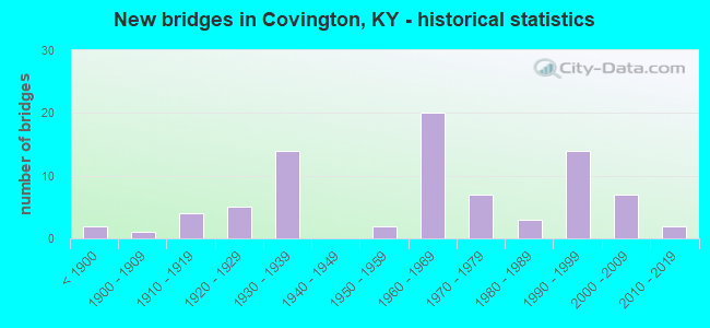
- New bridges - historical statistics
- 2Before 1900
- 11900-1909
- 41910-1919
- 51920-1929
- 141930-1939
- 21950-1959
- 201960-1969
- 71970-1979
- 31980-1989
- 141990-1999
- 72000-2009
- 22010-2019

- Reconstructed bridges - Historical Statistics
- 11950-1959
- 01960-1969
- 01970-1979
- 01980-1989
- 01990-1999
- 12000-2009


- Bridge Condition - Deck
- 59.4%Good
- 21.9%Satisfactory
- 15.6%Fair
- 3.1%Failed

- Bridge Condition - Superstructure
- 21.9%Very good
- 37.5%Good
- 15.6%Satisfactory
- 18.8%Fair
- 3.1%Poor
- 3.1%Failed

- Bridge Condition - Substructure
- 3.1%Very good
- 46.9%Good
- 15.6%Satisfactory
- 31.3%Fair
- 3.1%Failed

- Bridge Condition - Channel
- 17.6%Very good
- 35.3%Good
- 29.4%Satisfactory
- 17.6%Fair

- Bridge Condition - Culverts
- 50.0%Good
- 50.0%Fair
Find on map >> Show street view
Structure Number: 59B00044L, Location: SBL-.3M N-JEFFERSON ST OP (Lat: 39.076667, Lng: -84.520000), Route carried "under" structure: US 25, Year Built: 1960, Structure Length: 0. m, Average Daily Traffic: 9,685 (year 2018), Truck Traffic: 11%, Features Intersected: 11TH-12TH-LEWIS IN CVNGT, Facility Carried by Structure: I-75 NC
Minimum Vertical Clearance: 4.46m (14.63ft), Kilometerpoint: 20.469, Lanes on structure: 4, Lanes under structure: 4, Material/Design: Concrete continuous, Design/Construction: Tee Beam, Length of Maximum Span: 24.4m (80.1ft)
Find on map >> Show street view
Structure Number: 59B00044L, Location: SBL-.3M N-JEFFERSON ST OP (Lat: 39.076667, Lng: -84.520000), Route carried "under" structure: State highway 1120, Year Built: 1960, Structure Length: 0. m, Average Daily Traffic: 15,215 (year 2018), Truck Traffic: 9%, Features Intersected: 11TH-12TH-LEWIS IN CVNGT, Facility Carried by Structure: I-75 NC
Minimum Vertical Clearance: 4.46m (14.63ft), Kilometerpoint: 0.021, Lanes on structure: 4, Lanes under structure: 2, Material/Design: Concrete continuous, Design/Construction: Tee Beam, Length of Maximum Span: 24.4m (80.1ft)
Find on map >> Show street view
Structure Number: 59B00044R, Location: NBL-.3M N-JEFFERSON ST OP (Lat: 39.076667, Lng: -84.519722), Route carried "under" structure: US 25, Year Built: 1960, Structure Length: 0. m, Average Daily Traffic: 9,685 (year 2018), Truck Traffic: 11%, Features Intersected: US25,KY1120,(11TH,12TH,L, Facility Carried by Structure: I-75
Minimum Vertical Clearance: 4.46m (14.63ft), Kilometerpoint: 20.497, Lanes on structure: 3, Lanes under structure: 4, Material/Design: Concrete continuous, Design/Construction: Tee Beam, Length of Maximum Span: 24.4m (80.1ft)
Find on map >> Show street view
Structure Number: 59B00044R, Location: NBL-.3M N-JEFFERSON ST OP (Lat: 39.076667, Lng: -84.519722), Route carried "under" structure: State highway 1120, Year Built: 1960, Structure Length: 0. m, Average Daily Traffic: 15,215 (year 2018), Truck Traffic: 9%, Features Intersected: US25,KY1120,(11TH,12TH,L, Facility Carried by Structure: I-75
Minimum Vertical Clearance: 4.46m (14.63ft), Kilometerpoint: 0.039, Lanes on structure: 3, Lanes under structure: 2, Material/Design: Concrete continuous, Design/Construction: Tee Beam, Length of Maximum Span: 24.4m (80.1ft)
Find on map >> Show street view
Structure Number: 59B00048N, Location: SUSPENSION BR OVR OHIO RV (Lat: 39.092778, Lng: -84.510000), Route carried "under" structure: City street 2704, Year Built: 1867, Structure Length: 0. m, Features Intersected: OHIO RIVER, Facility Carried by Structure: KY 17
Minimum Vertical Clearance: 30+ m (98+ ft), Kilometerpoint: 0.063, Lanes on structure: 2, Lanes under structure: 1, Material/Design: Steel, Design/Construction: Suspension, Length of Maximum Span: 322.2m (1,057.1ft)
Find on map >> Show street view
Structure Number: 59B00049N, Location: CLAY WADE BAILEY OVR OHIO (Lat: 39.091314, Lng: -84.519361), Route carried "under" structure: City street 2609, Year Built: 1974, Structure Length: 0. m, Average Daily Traffic: 11,151 (year 2019), Features Intersected: OHIO RIVER, Facility Carried by Structure: US25/US42/US127
Minimum Vertical Clearance: 5.38m (17.65ft), Kilometerpoint: 0.555, Lanes on structure: 2, Lanes under structure: 3, Material/Design: Steel, Design/Construction: Truss - Thru, Length of Maximum Span: 205.7m (674.9ft)
Find on map >> Show street view
Structure Number: 59B00085N, Location: 500'S. SUSPENSION BRIDGE (Lat: 39.089722, Lng: -84.509167), Route carried "under" structure: City street 2010, Year Built: 1992, Structure Length: 0. m, Features Intersected: SECOND STREET, Facility Carried by Structure: SUSP. BRIDGE APPR
Minimum Vertical Clearance: 3.84m (12.60ft), Kilometerpoint: 0.607, Lanes on structure: 2, Lanes under structure: 2, Material/Design: Prestressed concrete, Design/Construction: Box Beam or Girders - Multiple, Length of Maximum Span: 15.8m (51.8ft)
Find on map >> Show street view
Structure Number: 59B00087N, Location: I-75 NB-EXIT E TO 5TH ST (Lat: 39.078056, Lng: -84.520278), Route carried "under" structure: Ramp Interstate 75, Year Built: 1993, Structure Length: 0. m, Average Daily Traffic: 159,350 (year 2017), Truck Traffic: 14%, Features Intersected: PIKE ST-ON RMP TO I-75 N
Minimum Vertical Clearance: 30+ m (98+ ft), Kilometerpoint: 306.786, Lanes on structure: 1, Lanes under structure: 1, Material/Design: Prestressed concrete, Design/Construction: Stringer/Multi-beam, Length of Maximum Span: 16.2m (53.1ft)
Find on map >> Show street view
Structure Number: 59B00088N, Location: I75 NB TO 5TH ST OVR 9TH (Lat: 39.079167, Lng: -84.521111), Route carried "under" structure: City street 2064, Year Built: 1993, Structure Length: 0. m, Average Daily Traffic: 129,380 (year 2006), Features Intersected: 9TH ST (I-75NB) RAMP'G', Facility Carried by Structure: I-75 RAMP
Minimum Vertical Clearance: 30+ m (98+ ft), Kilometerpoint: 0.686, Lanes on structure: 1, Lanes under structure: 1, Material/Design: Prestressed concrete continuous, Design/Construction: Stringer/Multi-beam, Length of Maximum Span: 16.2m (53.1ft)
Find on map >> Show street view
Structure Number: 59B00089N, Location: PIKE ST TO I75NB OVR 9TH (Lat: 39.079167, Lng: -84.521389), Route carried "under" structure: City street 2064, Year Built: 1993, Structure Length: 0. m, Average Daily Traffic: 4,461 (year 2006), Features Intersected: 9TH ST (COV), Facility Carried by Structure: I-75 RAMP
Minimum Vertical Clearance: 30+ m (98+ ft), Kilometerpoint: 0.698, Lanes on structure: 1, Lanes under structure: 1, Material/Design: Prestressed concrete continuous, Design/Construction: Stringer/Multi-beam, Length of Maximum Span: 16.2m (53.1ft)
Find on map >> Show street view
Structure Number: 59B00090N, Location: I-75 SB-EXIT TO PIKE ST (Lat: 39.078889, Lng: -84.521944), Route carried "under" structure: City street 2064, Year Built: 1993, Structure Length: 0. m, Average Daily Traffic: 4,461 (year 2006), Features Intersected: 9TH ST-COVINGTON, Facility Carried by Structure: I-75 RAMP
Minimum Vertical Clearance: 30+ m (98+ ft), Kilometerpoint: 0.758, Lanes on structure: 1, Lanes under structure: 1, Material/Design: Prestressed concrete continuous, Design/Construction: Stringer/Multi-beam, Length of Maximum Span: 16.2m (53.1ft)
Find on map >> Show street view
Structure Number: 59B00104N, Location: 1.0 MI E. JCT I 75 (Lat: 39.079544, Lng: -84.499750), Route carried "under" structure: State highway 9, Year Built: 2001, Structure Length: 0. m, Average Daily Traffic: 6,564 (year 2019), Truck Traffic: 8%, Features Intersected: LICKING RIVER CSX RR-LOW, Facility Carried by Structure: KY-1120
Minimum Vertical Clearance: 6.98m (22.90ft), Kilometerpoint: 35.595, Lanes on structure: 4, Lanes under structure: 4, Material/Design: Steel continuous, Design/Construction: Stringer/Multi-beam, Length of Maximum Span: 86.9m (285.1ft)
Find on map >> Show street view
Structure Number: 59B00106L, Location: .1 MI S OF FOWLER RD (Lat: 38.971667, Lng: -84.531667), Route carried "under" structure: State highway 1486, Year Built: 2002, Structure Length: 0. m, Average Daily Traffic: 804 (year 2020), Truck Traffic: 4%, Features Intersected: FOWLER CREEK ROAD, Facility Carried by Structure: MADISON PIKE NC
Minimum Vertical Clearance: 30+ m (98+ ft), Kilometerpoint: 5.491, Lanes on structure: 2, Lanes under structure: 2, Material/Design: Prestressed concrete continuous, Design/Construction: Stringer/Multi-beam, Length of Maximum Span: 32.0m (105.0ft)
Find on map >> Show street view
Structure Number: 59B00106R, Location: .1 MI S OF FOWLER CK. RD. (Lat: 38.971667, Lng: -84.531667), Route carried "under" structure: State highway 1486, Year Built: 2001, Structure Length: 0. m, Average Daily Traffic: 804 (year 2020), Truck Traffic: 4%, Features Intersected: FOWLER CREEK ROAD, Facility Carried by Structure: MADISON ROAD
Minimum Vertical Clearance: 30+ m (98+ ft), Kilometerpoint: 5.473, Lanes on structure: 2, Lanes under structure: 2, Material/Design: Prestressed concrete continuous, Design/Construction: Stringer/Multi-beam, Length of Maximum Span: 32.0m (105.0ft)
Find on map >> Show street view
Structure Number: 59C00037N, Location: PARKWAY AVE OVR HIGH ST (Lat: 39.088611, Lng: -84.535556), Route carried "under" structure: State highway 8, Year Built: 1960, Structure Length: 0. m, Average Daily Traffic: 6,141 (year 2020), Truck Traffic: 5%, Features Intersected: PARKWAY ST OVER KY8, Facility Carried by Structure: PARKWAY AVE
Minimum Vertical Clearance: 30+ m (98+ ft), Kilometerpoint: 9.030, Lanes on structure: 2, Lanes under structure: 2, Material/Design: Prestressed concrete, Design/Construction: Box Beam or Girders - Multiple, Length of Maximum Span: 28.7m (94.2ft)
Find on map >> Show street view
Structure Number: 59C00052N, Location: 750' SOU. JCT 35TH ST (Lat: 39.044167, Lng: -84.511389), Route carried "under" structure: City street 2604, Year Built: 1993, Structure Length: 0. m, Average Daily Traffic: 4,080 (year 2013), Features Intersected: WEST 43RD STREET, Facility Carried by Structure: CSX RAILROAD
Minimum Vertical Clearance: 4.95m (16.24ft), Kilometerpoint: 0.000, Lanes under structure: 2, Material/Design: Prestressed concrete, Design/Construction: Box Beam or Girders - Multiple, Length of Maximum Span: 12.5m (41.0ft)
Find on map >> Show street view
Structure Number: 59C00053N, Location: 750' SOUTH JCT 35 ST (Lat: 39.044167, Lng: -84.511389), Route carried "under" structure: City street 2468, Year Built: 1993, Structure Length: 0. m, Average Daily Traffic: 4,080 (year 2013), Features Intersected: 43 RD STREET, Facility Carried by Structure: WEST 43RD STREET
Minimum Vertical Clearance: 4.98m (16.34ft), Kilometerpoint: 0.536, Lanes under structure: 2, Material/Design: Prestressed concrete, Design/Construction: Box Beam or Girders - Multiple, Length of Maximum Span: 12.5m (41.0ft)
Find on map >> Show street view
Structure Number: 59R00602N, Location: APPRCH TO CLAY BAILEY BR (Lat: 39.087500, Lng: -84.518333), Route carried "under" structure: City street 2609, Year Built: 1930, Structure Length: 0. m, Average Daily Traffic: 11,151 (year 2019), Features Intersected: 3RD STREET, Facility Carried by Structure: CSX RAILROAD
Minimum Vertical Clearance: 11.90m (39.04ft), Kilometerpoint: 0.515, Lanes under structure: 3, Material/Design: Steel, Design/Construction: Stringer/Multi-beam, Length of Maximum Span: 0.3m (1.0ft)
Find on map >> Show street view
Structure Number: 59R00604N, Location: .5 MI-S.JCT KY 17 (Lat: 39.055000, Lng: -84.500833), Route carried "under" structure: State highway 16, Year Built: 1930, Structure Length: 0. m, Average Daily Traffic: 9,539 (year 2020), Truck Traffic: 4%, Features Intersected: JAMES AVENUE (30TH ST), Facility Carried by Structure: CSX RR
Minimum Vertical Clearance: 4.95m (16.24ft), Kilometerpoint: 24.935, Lanes under structure: 2, Material/Design: Steel, Design/Construction: Stringer/Multi-beam, Length of Maximum Span: 19.5m (64.0ft)
Find on map >> Show street view
Structure Number: 59R00606N, Location: KY17(GREENUP ST)NEAR 17TH (Lat: 39.071111, Lng: -84.503889), Route carried "under" structure: State highway 17, Year Built: 1927, Structure Length: 0. m, Average Daily Traffic: 4,864 (year 2019), Truck Traffic: 7%, Features Intersected: GREENUP AVENUE, Facility Carried by Structure: CSX RR
Minimum Vertical Clearance: 4.19m (13.75ft), Kilometerpoint: 36.352, Lanes under structure: 2, Material/Design: Steel, Design/Construction: Stringer/Multi-beam, Length of Maximum Span: 14.6m (47.9ft)
Find on map >> Show street view
Structure Number: 59R00608N, Location: SCOTT ST NEAR 17TH ST (Lat: 39.070833, Lng: -84.505278), Route carried "under" structure: State highway 17, Year Built: 1927, Structure Length: 0. m, Average Daily Traffic: 4,583 (year 2019), Truck Traffic: 9%, Features Intersected: SCOTT BOULEVARD, Facility Carried by Structure: CSX RR
Minimum Vertical Clearance: 3.71m (12.17ft), Kilometerpoint: 36.197, Lanes under structure: 2, Material/Design: Steel, Design/Construction: Stringer/Multi-beam, Length of Maximum Span: 11.9m (39.0ft)
Find on map >> Show street view
Structure Number: 59R00610N, Location: MAIN ST BTWN 4TH&5TH STS (Lat: 39.086111, Lng: -84.517222), Route carried "under" structure: State highway 8, Year Built: 1930, Structure Length: 0. m, Average Daily Traffic: 8,107 (year 2019), Truck Traffic: 14%, Features Intersected: 4TH, 5TH, AND MAIN STS., Facility Carried by Structure: CSX RAILROAD
Minimum Vertical Clearance: 7.72m (25.33ft), Kilometerpoint: 11.113, Lanes under structure: 2, Material/Design: Steel, Design/Construction: Stringer/Multi-beam, Length of Maximum Span: 18.3m (60.0ft)
Find on map >> Show street view
Structure Number: 59R00610N, Location: MAIN ST BTWN 4TH&5TH STS (Lat: 39.086111, Lng: -84.517222), Route carried "under" structure: State highway 8, Year Built: 1930, Structure Length: 0. m, Average Daily Traffic: 8,653 (year 2019), Truck Traffic: 14%, Features Intersected: 4TH, 5TH, AND MAIN STS., Facility Carried by Structure: CSX RAILROAD
Minimum Vertical Clearance: 30+ m (98+ ft), Kilometerpoint: 10.924, Lanes under structure: 3, Material/Design: Steel, Design/Construction: Stringer/Multi-beam, Length of Maximum Span: 18.3m (60.0ft)
Find on map >> Show street view
Structure Number: 59R00610N, Location: MAIN ST BTWN 4TH&5TH STS (Lat: 39.086111, Lng: -84.517222), Route carried "under" structure: US 25, Year Built: 1930, Structure Length: 0. m, Average Daily Traffic: 9,693 (year 2015), Truck Traffic: 11%, Features Intersected: 4TH, 5TH, AND MAIN STS., Facility Carried by Structure: CSX RAILROAD
Minimum Vertical Clearance: 30+ m (98+ ft), Kilometerpoint: 21.617, Lanes under structure: 2, Material/Design: Steel, Design/Construction: Stringer/Multi-beam, Length of Maximum Span: 18.3m (60.0ft)
Find on map >> Show street view
Structure Number: 59R00617N, Location: PIKE ST NR RUSSELL ST (Lat: 39.082500, Lng: -84.513333), Route carried "under" structure: City street 2218, Year Built: 1930, Structure Length: 0. m, Average Daily Traffic: 4,230 (year 2020), Features Intersected: CSX RR @ PIKE ST (COV), Facility Carried by Structure: WEST PIKE STREET
Minimum Vertical Clearance: 4.32m (14.17ft), Kilometerpoint: 0.314, Lanes under structure: 2, Material/Design: Steel continuous, Design/Construction: Stringer/Multi-beam, Length of Maximum Span: 15.2m (49.9ft)
Find on map >> Show street view
Structure Number: 59R00618N, Location: MADISON ST NR 17TH ST (Lat: 39.070833, Lng: -84.506944), Route carried "under" structure: City street 2103, Year Built: 1930, Structure Length: 0. m, Average Daily Traffic: 13,080 (year 2019), Features Intersected: CSX RR @ MADISON ST (COV, Facility Carried by Structure: MADISON AVENUE
Minimum Vertical Clearance: 4.40m (14.44ft), Kilometerpoint: 0.423, Lanes under structure: 2, Material/Design: Steel, Design/Construction: Stringer/Multi-beam, Length of Maximum Span: 17.9m (58.7ft)
Find on map >> Show street view
Structure Number: 59R00619N, Location: CAROLINE ST NR 36TH ST (Lat: 39.048611, Lng: -84.505278), Route carried "under" structure: City street 2403, Year Built: 1930, Structure Length: 0. m, Average Daily Traffic: 2,389 (year 2019), Features Intersected: CSX RR @ CAROLINE ST (CO, Facility Carried by Structure: CAROLINE STREET
Minimum Vertical Clearance: 4.19m (13.75ft), Kilometerpoint: 0.156, Lanes under structure: 2, Material/Design: Concrete continuous, Design/Construction: Tee Beam, Length of Maximum Span: 5.8m (19.0ft)
Find on map >> Show street view
Structure Number: 59R00620N, Location: RUSSELL ST NR PIKE ST (Lat: 39.082222, Lng: -84.513056), Route carried "under" structure: City street 2093, Year Built: 1930, Structure Length: 0. m, Average Daily Traffic: 2,469 (year 2020), Truck Traffic: 4%, Features Intersected: CSX RR @ RUSSELL ST (COV, Facility Carried by Structure: RUSSELL STREET
Minimum Vertical Clearance: 4.14m (13.58ft), Kilometerpoint: 1.928, Lanes under structure: 2, Material/Design: Steel continuous, Design/Construction: Stringer/Multi-beam, Length of Maximum Span: 15.2m (49.9ft)
Find on map >> Show street view
Structure Number: 59R00621N, Location: 8TH ST NR RUSSELL ST (Lat: 39.081944, Lng: -84.512222), Route carried "under" structure: City street 2071, Year Built: 1930, Structure Length: 0. m, Average Daily Traffic: 3,387 (year 2018), Features Intersected: CSX RR OVER 8TH ST (COV), Facility Carried by Structure: EAST 8TH STREET
Minimum Vertical Clearance: 3.73m (12.24ft), Kilometerpoint: 0.217, Lanes under structure: 2, Material/Design: Concrete continuous, Design/Construction: Slab, Length of Maximum Span: 4.6m (15.1ft)
Find on map >> Show street view
Structure Number: 59R00622N, Location: @ W. 6TH & JOHNSONST (Lat: 39.084167, Lng: -84.515556), Route carried "under" structure: City street 2206, Year Built: 1919, Structure Length: 0. m, Features Intersected: CSX RAILROAD, Facility Carried by Structure: WEST 6TH ST
Minimum Vertical Clearance: 4.32m (14.17ft), Kilometerpoint: 0.375, Lanes under structure: 2, Material/Design: Concrete, Design/Construction: Slab, Length of Maximum Span: 7.0m (23.0ft)
Find on map >> Show street view
Structure Number: 59R00623N, Location: AT JCT 47 TH. ST. (Lat: 39.034444, Lng: -84.494444), Route carried "under" structure: City street 2253, Year Built: 1911, Structure Length: 0. m, Average Daily Traffic: 1,353 (year 2006), Features Intersected: CSX RR OVER 47TH ST (COV, Facility Carried by Structure: 47TH ST
Minimum Vertical Clearance: 3.51m (11.52ft), Kilometerpoint: 0.053, Lanes under structure: 1, Material/Design: Steel, Design/Construction: Stringer/Multi-beam, Length of Maximum Span: 15.2m (49.9ft)
Find on map >> Show street view
Structure Number: 59R00624N, Location: BETWN GLEN & HUNT'NTON (Lat: 39.043333, Lng: -84.496667), Route carried "under" structure: City street 2458, Year Built: 1930, Structure Length: 0. m, Average Daily Traffic: 1,353 (year 2006), Features Intersected: CSX RAILROAD OVER 40TH S, Facility Carried by Structure: EAST 40TH ST
Minimum Vertical Clearance: 3.58m (11.75ft), Kilometerpoint: 0.745, Lanes under structure: 2, Material/Design: Concrete, Design/Construction: Slab, Length of Maximum Span: 8.5m (27.9ft)
Find on map >> Show street view
Structure Number: 59R00625N, Location: 75'N. OF E. 16 ST N COV. (Lat: 39.072222, Lng: -84.502500), Route carried "under" structure: City street 2133, Year Built: 1901, Structure Length: 0. m, Average Daily Traffic: 1,353 (year 2006), Features Intersected: CSX RR /GARRARD MP662.4, Facility Carried by Structure: GARRARD STREET S
Minimum Vertical Clearance: 4.40m (14.44ft), Kilometerpoint: 0.832, Lanes under structure: 2, Material/Design: Steel, Design/Construction: Stringer/Multi-beam, Length of Maximum Span: 18.3m (60.0ft)
Find on map >> Show street view
Structure Number: 59R00626N, Location: @ CRAIG AVE. (Lat: 39.083611, Lng: -84.515000), Route carried "under" structure: City street 2214, Year Built: 1919, Structure Length: 0. m, Average Daily Traffic: 80 (year 2006), Features Intersected: CSX RR OVER PERSHING AVE, Facility Carried by Structure: PERSHING AVE
Minimum Vertical Clearance: 4.16m (13.65ft), Kilometerpoint: 0.029, Lanes under structure: 1, Material/Design: Concrete, Design/Construction: Slab, Length of Maximum Span: 7.3m (24.0ft)
Find on map >> Show street view
Structure Number: 59R00627N, Location: BETWEEN 6 & 7 STREETS (Lat: 39.083333, Lng: -84.514722), Route carried "under" structure: City street 2072, Year Built: 1919, Structure Length: 0. m, Features Intersected: CSX RR OVER CRAIG ST, Facility Carried by Structure: WEST 7TH ST
Minimum Vertical Clearance: 4.27m (14.01ft), Kilometerpoint: 0.016, Lanes under structure: 2, Material/Design: Concrete, Design/Construction: Slab, Length of Maximum Span: 5.5m (18.0ft)
Find on map >> Show street view
Structure Number: 59R00629N, Location: .5 MI-NE-JCT KY 17 (Lat: 39.073333, Lng: -84.501667), Route carried "under" structure: City street 2115, Year Built: 1927, Structure Length: 0. m, Average Daily Traffic: 60 (year 2006), Features Intersected: CSX RR OVER PATTON ST, Facility Carried by Structure: PATTON ST
Minimum Vertical Clearance: 5.37m (17.62ft), Kilometerpoint: 0.084, Lanes under structure: 2, Material/Design: Steel, Design/Construction: Stringer/Multi-beam, Length of Maximum Span: 9.1m (29.9ft)
Find on map >> Show street view
Structure Number: 59R00630N, Location: .5 MI-NE JCT KY 17 (Lat: 39.074722, Lng: -84.500278), Route carried "under" structure: City street 2002, Year Built: 1927, Structure Length: 0. m, Average Daily Traffic: 2,929 (year 2018), Features Intersected: CSX RR OVER 15TH ST, Facility Carried by Structure: EAST 15TH STREET
Minimum Vertical Clearance: 4.72m (15.49ft), Kilometerpoint: 0.645, Lanes under structure: 2, Material/Design: Steel, Design/Construction: Stringer/Multi-beam, Length of Maximum Span: 15.8m (51.8ft)
Find on map >> Show street view
Structure Number: 59R00631N, Location: .5 MI-NE JCT KY17 (Lat: 39.075278, Lng: -84.499722), Route carried "under" structure: City street 2222, Year Built: 1927, Structure Length: 0. m, Average Daily Traffic: 60 (year 2006), Features Intersected: MARYLAND AVE UNDER CSX R, Facility Carried by Structure: MARYLAND AVE
Minimum Vertical Clearance: 4.97m (16.31ft), Kilometerpoint: 0.813, Lanes under structure: 2, Material/Design: Steel, Design/Construction: Stringer/Multi-beam, Length of Maximum Span: 28.0m (91.9ft)
Find on map >> Show street view
Structure Number: 59R00633N, Location: OVER NORTH END BAKEWELL (Lat: 39.087500, Lng: -84.518889), Route carried "under" structure: City street 2026, Year Built: 1932, Structure Length: 0. m, Average Daily Traffic: 558 (year 2006), Features Intersected: CSX RR OVR BAKEWELL ST, Facility Carried by Structure: BAKEWELL STREET N
Minimum Vertical Clearance: 11.81m (38.75ft), Kilometerpoint: 0.000, Lanes under structure: 2, Material/Design: Steel, Design/Construction: Stringer/Multi-beam, Length of Maximum Span: 25.4m (83.3ft)