Bridge Statistics for Cranston, Rhode Island (RI)
Condition, Traffic, Stress, Structural Evaluation, Project Costs
- National Bridge Inventory (NBI) Statistics
- 92Number of bridges
- 797ft / 243mTotal length
- $195,936,000Total costs
- 2,644,609Total average daily traffic
- 226,626Total average daily truck traffic
- National Bridge Inventory (NBI) Registered Bridges for Cranston
- No street view available for this location
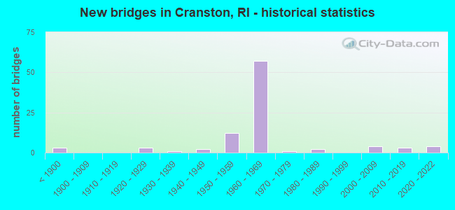
- New bridges - historical statistics
- 3Before 1900
- 31920-1929
- 11930-1939
- 21940-1949
- 121950-1959
- 571960-1969
- 11970-1979
- 21980-1989
- 42000-2009
- 32010-2019
- 42020-2022

- Reconstructed bridges - Historical Statistics
- 11920-1929
- 01930-1939
- 01940-1949
- 01950-1959
- 01960-1969
- 11970-1979
- 141980-1989
- 71990-1999
- 22000-2009


- Bridge Condition - Deck
- 5.9%Very good
- 23.5%Good
- 37.3%Satisfactory
- 21.6%Fair
- 7.8%Poor
- 2.0%Serious
- 2.0%Critical

- Bridge Condition - Superstructure
- 6.9%Very good
- 5.2%Good
- 31.0%Satisfactory
- 34.5%Fair
- 19.0%Poor
- 3.4%Serious

- Bridge Condition - Substructure
- 13.8%Good
- 44.8%Satisfactory
- 25.9%Fair
- 15.5%Poor

- Bridge Condition - Channel
- 26.1%Good
- 30.4%Satisfactory
- 39.1%Fair
- 4.3%Poor

- Bridge Condition - Culverts
- 12.5%Very good
- 37.5%Good
- 37.5%Satisfactory
- 12.5%Poor
Find on map >> Show street view
Structure Number: 663, Location: 3.5 Mi N of JCT RI 37 (Lat: 41.781403, Lng: -71.422819), Route carried "under" structure: City street , Year Built: 1965, Structure Length: 0. m, Average Daily Traffic: 1,000 (year 2008), Truck Traffic: 2%, Features Intersected: WELLINGTON AV & AMTRAK, Facility Carried by Structure: I-95 RAMP B-EL
Minimum Vertical Clearance: 5.38m (17.65ft), Kilometerpoint: 0.000, Lanes on structure: 1, Lanes under structure: 2, Material/Design: Steel, Design/Construction: Stringer/Multi-beam, Length of Maximum Span: 51.5m (169.0ft)
Find on map >> Show street view
Structure Number: 664, Location: 2.2 Mi S of JCT I-195 (Lat: 41.782922, Lng: -71.423817), Route carried "under" structure: Interstate 95, Year Built: 1965, Structure Length: 0. m, Average Daily Traffic: 115,700 (year 2008), Truck Traffic: 10%, Features Intersected: I-95 NB & SB, Facility Carried by Structure: RI 10 RAMP BC
Minimum Vertical Clearance: 4.37m (14.34ft), Kilometerpoint: 0.000, Lanes on structure: 1, Lanes under structure: 10, Material/Design: Steel, Design/Construction: Stringer/Multi-beam, Length of Maximum Span: 21.0m (68.9ft)
Find on map >> Show street view
Structure Number: 665, Location: 3.0 Mi N of JCT RI 37 (Lat: 41.781894, Lng: -71.423492), Route carried "under" structure: Interstate 95, Year Built: 1965, Structure Length: 0. m, Average Daily Traffic: 110,000 (year 2008), Truck Traffic: 10%, Features Intersected: I-95 NB & SB, AMTRAK, Facility Carried by Structure: RI 10 HUNTNGTN EXP
Minimum Vertical Clearance: 4.27m (14.01ft), Kilometerpoint: 0.000, Lanes on structure: 4, Lanes under structure: 8, Material/Design: Steel, Design/Construction: Stringer/Multi-beam, Length of Maximum Span: 48.5m (159.1ft)
Find on map >> Show street view
Structure Number: 665, Location: 3.0 Mi N of JCT RI 37 (Lat: 41.781894, Lng: -71.423492), Route carried "under" structure: Interstate 95, Year Built: 1965, Structure Length: 0. m, Average Daily Traffic: 110,000 (year 2008), Truck Traffic: 10%, Features Intersected: I-95 NB & SB, AMTRAK, Facility Carried by Structure: RI 10 HUNTNGTN EXP
Minimum Vertical Clearance: 4.27m (14.01ft), Kilometerpoint: 0.000, Lanes on structure: 4, Lanes under structure: 12, Material/Design: Steel, Design/Construction: Stringer/Multi-beam, Length of Maximum Span: 48.5m (159.1ft)
Find on map >> Show street view
Structure Number: 666, Location: 2.2 Mi S of JCT I-195 (Lat: 41.780806, Lng: -71.424836), Route carried "under" structure: Interstate 95, Year Built: 1965, Structure Length: 0. m, Average Daily Traffic: 110,000 (year 2008), Truck Traffic: 10%, Features Intersected: I-95 NB & SB, Facility Carried by Structure: RI 10 RAMP DB
Minimum Vertical Clearance: 4.50m (14.76ft), Kilometerpoint: 0.000, Lanes on structure: 1, Lanes under structure: 9, Material/Design: Steel, Design/Construction: Stringer/Multi-beam, Length of Maximum Span: 22.9m (75.1ft)
Find on map >> Show street view
Structure Number: 668, Location: 0.1 Mi W of JCT I-95 (Lat: 41.782678, Lng: -71.430653), Route carried "under" structure: State highway 10, Year Built: 1966, Structure Length: 0. m, Average Daily Traffic: 51,500 (year 2008), Truck Traffic: 10%, Features Intersected: RI 10 HUNTINGTON EXPRESS, Facility Carried by Structure: PONTIAC AV
Minimum Vertical Clearance: 4.24m (13.91ft), Kilometerpoint: 0.000, Lanes on structure: 2, Lanes under structure: 6, Material/Design: Steel, Design/Construction: Stringer/Multi-beam, Length of Maximum Span: 22.6m (74.1ft)
Find on map >> Show street view
Structure Number: 675, Location: 0.5 Mi E of JCT I-95 (Lat: 41.775614, Lng: -71.418428), Route carried "under" structure: State highway 10, Year Built: 1966, Structure Length: 0. m, Average Daily Traffic: 20,200 (year 2021), Truck Traffic: 4%, Features Intersected: RI 10 NORTH, RAMP LANE, Facility Carried by Structure: RI 12 PARK AV
Minimum Vertical Clearance: 4.44m (14.57ft), Kilometerpoint: 0.000, Lanes on structure: 4, Lanes under structure: 1, Material/Design: Steel, Design/Construction: Stringer/Multi-beam, Length of Maximum Span: 19.8m (65.0ft)
Find on map >> Show street view
Structure Number: 676, Location: 0.3 Mi W of JCT US 1 (Lat: 41.777036, Lng: -71.426231), Route carried "under" structure: Interstate 95, Year Built: 1965, Structure Length: 0. m, Average Daily Traffic: 10,900 (year 2021), Truck Traffic: 7%, Features Intersected: I-95 NB & SB, Facility Carried by Structure: RI 12 PARK AV
Minimum Vertical Clearance: 4.52m (14.83ft), Kilometerpoint: 0.000, Lanes on structure: 2, Lanes under structure: 9, Material/Design: Steel, Design/Construction: Stringer/Multi-beam, Length of Maximum Span: 27.2m (89.2ft)
Find on map >> Show street view
Structure Number: 677, Location: 0.1 Mi W of WELLINGTON AV (Lat: 41.772664, Lng: -71.427828), Route carried "under" structure: Interstate 95, Year Built: 1965, Structure Length: 0. m, Average Daily Traffic: 147,500 (year 2008), Truck Traffic: 10%, Features Intersected: I-95 NB & SB, Facility Carried by Structure: LAURENS ST
Minimum Vertical Clearance: 4.32m (14.17ft), Kilometerpoint: 0.000, Lanes on structure: 2, Lanes under structure: 8, Material/Design: Steel, Design/Construction: Stringer/Multi-beam, Length of Maximum Span: 26.8m (87.9ft)
Find on map >> Show street view
Structure Number: 678, Location: 0.1 Mi W of WELLINGTON AV (Lat: 41.767219, Lng: -71.429803), Route carried "under" structure: Interstate 95, Year Built: 1965, Structure Length: 0. m, Average Daily Traffic: 147,500 (year 2008), Truck Traffic: 10%, Features Intersected: I-95 NB & SB, Facility Carried by Structure: MILFORD ST
Minimum Vertical Clearance: 4.39m (14.40ft), Kilometerpoint: 0.000, Lanes on structure: 2, Lanes under structure: 8, Material/Design: Steel, Design/Construction: Stringer/Multi-beam, Length of Maximum Span: 27.2m (89.2ft)
Find on map >> Show street view
Structure Number: 728, Location: 0.2 Mi E of JCT RI 5 (Lat: 41.755656, Lng: -71.480244), Route carried "under" structure: Interstate 295, Year Built: 1968, Structure Length: 0. m, Average Daily Traffic: 31,251 (year 2021), Truck Traffic: 10%, Features Intersected: I-295 NB, Facility Carried by Structure: RI 37 EB & WB
Minimum Vertical Clearance: 5.01m (16.44ft), Kilometerpoint: 0.000, Lanes on structure: 5, Lanes under structure: 3, Material/Design: Steel, Design/Construction: Stringer/Multi-beam, Length of Maximum Span: 36.0m (118.1ft)
Find on map >> Show street view
Structure Number: 7282, Location: 0.2 MI E of JCT RI 5 (Lat: 41.755442, Lng: -71.481194), Route carried "under" structure: Interstate 295, Year Built: 1969, Structure Length: 0. m, Average Daily Traffic: 31,251 (year 2021), Truck Traffic: 10%, Features Intersected: I-295 SB, Facility Carried by Structure: RI 37 EB & WB
Minimum Vertical Clearance: 5.03m (16.50ft), Kilometerpoint: 0.000, Lanes on structure: 6, Lanes under structure: 3, Material/Design: Steel, Design/Construction: Stringer/Multi-beam, Length of Maximum Span: 32.0m (105.0ft)
Find on map >> Show street view
Structure Number: 729, Location: 1.25 Mi S of JCT RI 5 (Lat: 41.766831, Lng: -71.482028), Route carried "under" structure: Interstate 295, Year Built: 1968, Structure Length: 0. m, Average Daily Traffic: 11,658 (year 2021), Truck Traffic: 5%, Features Intersected: I-295 NB, Facility Carried by Structure: RI 51 PHENIX AV
Minimum Vertical Clearance: 4.93m (16.17ft), Kilometerpoint: 0.000, Lanes on structure: 2, Lanes under structure: 2, Material/Design: Steel, Design/Construction: Stringer/Multi-beam, Length of Maximum Span: 39.0m (128.0ft)
Find on map >> Show street view
Structure Number: 7292, Location: 1.25 Mi S of JCT RI 5 (Lat: 41.765533, Lng: -71.482506), Route carried "under" structure: Interstate 295, Year Built: 1968, Structure Length: 0. m, Average Daily Traffic: 11,658 (year 2021), Truck Traffic: 5%, Features Intersected: I-295 SB, Facility Carried by Structure: RI 51 PHENIX AV
Minimum Vertical Clearance: 5.23m (17.16ft), Kilometerpoint: 0.000, Lanes on structure: 2, Lanes under structure: 2, Material/Design: Steel, Design/Construction: Stringer/Multi-beam, Length of Maximum Span: 27.5m (90.2ft)
Find on map >> Show street view
Structure Number: 731, Location: 1.6 Mi W of JCT RI 5 (Lat: 41.780350, Lng: -71.500944), Route carried "under" structure: Interstate 295, Year Built: 1969, Structure Length: 0. m, Average Daily Traffic: 9,841 (year 2021), Truck Traffic: 9%, Features Intersected: I-295 NB & SB, Facility Carried by Structure: RI 12 SCITUATE AV
Minimum Vertical Clearance: 4.92m (16.14ft), Kilometerpoint: 0.000, Lanes on structure: 2, Lanes under structure: 4, Material/Design: Steel continuous, Design/Construction: Stringer/Multi-beam, Length of Maximum Span: 34.7m (113.8ft)
Find on map >> Show street view
Structure Number: 7325, Location: I-295 @ Exit 4 (Lat: 41.788956, Lng: -71.506061), Route carried "under" structure: State highway 14, Year Built: 2020, Structure Length: 0. m, Average Daily Traffic: 1 (year 2008), Features Intersected: RI 14 PLAINFIELD PIKE, Facility Carried by Structure: I-295 NB
Minimum Vertical Clearance: 4.75m (15.58ft), Kilometerpoint: 0.000, Lanes on structure: 3, Lanes under structure: 2, Material/Design: Steel, Design/Construction: Stringer/Multi-beam, Length of Maximum Span: 17.7m (58.1ft)
Find on map >> Show street view
Structure Number: 7327, Location: I-295 @ Exit 4 (Lat: 41.788925, Lng: -71.506592), Route carried "under" structure: State highway 14, Year Built: 2020, Structure Length: 0. m, Average Daily Traffic: 42,300 (year 2021), Truck Traffic: 32%, Features Intersected: RI 14 PLAINFIELD PIKE, Facility Carried by Structure: I-295 SB
Minimum Vertical Clearance: 4.48m (14.70ft), Kilometerpoint: 0.000, Lanes on structure: 2, Lanes under structure: 2, Material/Design: Steel, Design/Construction: Stringer/Multi-beam, Length of Maximum Span: 17.7m (58.1ft)