Bridge Statistics for Danville, Pennsylvania (PA)
Condition, Traffic, Stress, Structural Evaluation, Project Costs
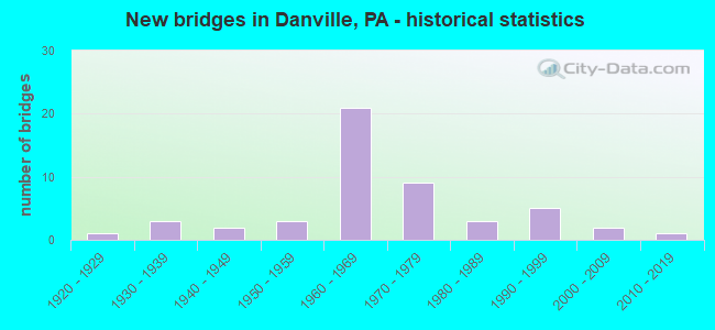
- New bridges - historical statistics
- 11920-1929
- 31930-1939
- 21940-1949
- 31950-1959
- 211960-1969
- 91970-1979
- 31980-1989
- 51990-1999
- 22000-2009
- 12010-2019

- Reconstructed bridges - Historical Statistics
- 11960-1969
- 11970-1979
- 71980-1989
- 11990-1999
- 32000-2009
- 12010-2019


- Bridge Condition - Deck
- 18.8%Very good
- 40.6%Good
- 21.9%Satisfactory
- 12.5%Fair
- 6.3%Poor

- Bridge Condition - Superstructure
- 18.8%Very good
- 37.5%Good
- 25.0%Satisfactory
- 15.6%Fair
- 3.1%Poor

- Bridge Condition - Substructure
- 3.1%Very good
- 56.3%Good
- 34.4%Satisfactory
- 6.3%Fair

- Bridge Condition - Channel
- 22.9%Very good
- 8.6%Good
- 20.0%Satisfactory
- 34.3%Fair
- 14.3%Poor

- Bridge Condition - Culverts
- 75.0%Good
- 25.0%Satisfactory
Find on map >> Show street view
Structure Number: 46843, Location: 1.0 MI NE OF MAUSDALE (Lat: 40.993517, Lng: -76.618797), Route carried "on" structure: City street , Year Built: 2011, Status: Open, Structure Length: 1.98m (6.50ft), Average Daily Traffic: 45 (year 2017), Average Future Daily Traffic: 53 (year 2039), Design Load: HL 93, Features Intersected: MAHONING CREEK, Facility Carried by Structure: T-386 CTY BR#20
Minimum Vertical Clearance: 30+ m (98+ ft), Kilometerpoint: 0.000, Lanes on structure: 2, Owner: County Highway Agency, Approaching Roadway Width: 6.7m (22.0ft), Material/Design: Prestressed concrete, Design/Construction: Box Beam or Girders - Single/Spread, Number Of Spans In Main Unit: 1, Length of Maximum Span: 18.9m (62.0ft), Curb or Sidewalk Widths: Left: 0.2m (0.7ft), Right: 0.2m (0.7ft), Curb-To-Curb Width: 6.7m (22.0ft), Out-to-Out Width: 7.7m (25.3ft)
Condition: Deck: Very good, Superstructure: Very good, Substructure: Very good, Channel: Very good, Operating Rating: 63.5 metric tons, Method Used To Determine Operating Rating: Assigned ratings based on Load and Resistance Factor Design (LRFD) reported by rating factor (RF) using HL93 loadings, Inventory Rating: 39.9 metric tons, Method Used To Determine Inventory Rating: Assigned ratings based on Load and Resistance Factor Design (LRFD) reported by rating factor (RF) using HL93 loadings, Structural Evaluation: Equal to present desirable criteria, Deck Geometry: Somewhat better than minimum adequacy, Waterway Adequacy: Equal to present desirable criteria, Approach Roadway Alignment: Equal to present desirable criteria, Designated Inspection Frequency: Every 24 months, Inspection Date: May 2021, Deck Structure Type: Concrete Cast-file-Place, Wearing Surface/Protective System: Wearing Surface: Monolithic Concrete, Deck Protection: Epoxy Coated Reinforcing
Find on map >> Show street view
Structure Number: 12488, Location: 4 MI E OF DANVILLE EXIT (Lat: 41.003333, Lng: -76.566667), Route carried "under" structure: Interstate 80, Year Built: 1963, Structure Length: 0. m, Average Daily Traffic: 15,264 (year 2021), Truck Traffic: 45%, Features Intersected: I-80 EBL & WBL, Facility Carried by Structure: W HEMLOCKRD SR4053
Minimum Vertical Clearance: 4.95m (16.24ft), Kilometerpoint: 0.000, Lanes on structure: 2, Lanes under structure: 4, Material/Design: Prestressed concrete, Design/Construction: Box Beam or Girders - Single/Spread, Length of Maximum Span: 20.1m (65.9ft)
Find on map >> Show street view
Structure Number: 12488, Location: 4 MI E OF DANVILLE EXIT (Lat: 41.003333, Lng: -76.566667), Route carried "under" structure: Interstate 80, Year Built: 1963, Structure Length: 0. m, Average Daily Traffic: 14,851 (year 2021), Truck Traffic: 45%, Features Intersected: I-80 EBL & WBL, Facility Carried by Structure: W HEMLOCKRD SR4053
Minimum Vertical Clearance: 5.11m (16.77ft), Kilometerpoint: 0.000, Lanes on structure: 2, Lanes under structure: 4, Material/Design: Prestressed concrete, Design/Construction: Box Beam or Girders - Single/Spread, Length of Maximum Span: 20.1m (65.9ft)
Find on map >> Show street view
Structure Number: 28351, Location: DANVILLE INTERCHANGE (Lat: 40.996153, Lng: -76.644517), Route carried "under" structure: State highway 54, Year Built: 1963, Structure Length: 0. m, Average Daily Traffic: 6,873 (year 2021), Truck Traffic: 13%, Features Intersected: SR 54 & INDIAN CREEK, Facility Carried by Structure: I-80 EBL
Minimum Vertical Clearance: 4.40m (14.44ft), Kilometerpoint: 14.912, Lanes on structure: 2, Lanes under structure: 4, Material/Design: Steel, Design/Construction: Stringer/Multi-beam, Length of Maximum Span: 32.6m (107.0ft)
Find on map >> Show street view
Structure Number: 28351, Location: DANVILLE INTERCHANGE (Lat: 40.996153, Lng: -76.644517), Route carried "under" structure: State highway 54, Year Built: 1963, Structure Length: 0. m, Average Daily Traffic: 6,650 (year 2021), Truck Traffic: 13%, Features Intersected: SR 54 & INDIAN CREEK, Facility Carried by Structure: I-80 EBL
Minimum Vertical Clearance: 4.40m (14.44ft), Kilometerpoint: 14.911, Lanes on structure: 2, Lanes under structure: 4, Material/Design: Steel, Design/Construction: Stringer/Multi-beam, Length of Maximum Span: 32.6m (107.0ft)
Find on map >> Show street view
Structure Number: 28352, Location: DANVILLE INTERCHANGE (Lat: 40.996181, Lng: -76.644997), Route carried "under" structure: State highway 54, Year Built: 1963, Structure Length: 0. m, Average Daily Traffic: 6,873 (year 2021), Truck Traffic: 13%, Features Intersected: SR 54 & INDIAN CREEK, Facility Carried by Structure: I-80 WBL
Minimum Vertical Clearance: 4.42m (14.50ft), Kilometerpoint: 14.912, Lanes on structure: 3, Lanes under structure: 2, Material/Design: Steel, Design/Construction: Stringer/Multi-beam, Length of Maximum Span: 32.6m (107.0ft)
Find on map >> Show street view
Structure Number: 28352, Location: DANVILLE INTERCHANGE (Lat: 40.996181, Lng: -76.644997), Route carried "under" structure: State highway 54, Year Built: 1963, Structure Length: 0. m, Average Daily Traffic: 6,650 (year 2021), Truck Traffic: 13%, Features Intersected: SR 54 & INDIAN CREEK, Facility Carried by Structure: I-80 WBL
Minimum Vertical Clearance: 4.42m (14.50ft), Kilometerpoint: 14.911, Lanes on structure: 3, Lanes under structure: 2, Material/Design: Steel, Design/Construction: Stringer/Multi-beam, Length of Maximum Span: 32.6m (107.0ft)
Find on map >> Show street view
Structure Number: 28374, Location: 4.5 MI NE OF DANVILLE (Lat: 40.999944, Lng: -76.615253), Route carried "under" structure: Interstate 80, Year Built: 1963, Structure Length: 0. m, Average Daily Traffic: 15,264 (year 2021), Truck Traffic: 45%, Features Intersected: OVER I-80 EBL AND WBL, Facility Carried by Structure: SR 642
Minimum Vertical Clearance: 5.16m (16.93ft), Kilometerpoint: 14.655, Lanes on structure: 2, Lanes under structure: 4, Material/Design: Prestressed concrete, Design/Construction: Stringer/Multi-beam, Length of Maximum Span: 23.8m (78.1ft)
Find on map >> Show street view
Structure Number: 28374, Location: 4.5 MI NE OF DANVILLE (Lat: 40.999944, Lng: -76.615253), Route carried "under" structure: Interstate 80, Year Built: 1963, Structure Length: 0. m, Average Daily Traffic: 14,851 (year 2021), Truck Traffic: 45%, Features Intersected: OVER I-80 EBL AND WBL, Facility Carried by Structure: SR 642
Minimum Vertical Clearance: 5.16m (16.93ft), Kilometerpoint: 14.602, Lanes on structure: 2, Lanes under structure: 4, Material/Design: Prestressed concrete, Design/Construction: Stringer/Multi-beam, Length of Maximum Span: 23.8m (78.1ft)
Find on map >> Show street view
Structure Number: 28403, Location: 2.5 MI E OF DANVILLE EXIT (Lat: 41.002375, Lng: -76.592081), Route carried "under" structure: Interstate 80, Year Built: 1963, Structure Length: 0. m, Average Daily Traffic: 15,264 (year 2021), Truck Traffic: 45%, Features Intersected: SR 2007 OVER I-80, Facility Carried by Structure: SR 2007
Minimum Vertical Clearance: 5.21m (17.09ft), Kilometerpoint: 16.298, Lanes on structure: 2, Lanes under structure: 4, Material/Design: Prestressed concrete, Design/Construction: Stringer/Multi-beam, Length of Maximum Span: 21.6m (70.9ft)
Find on map >> Show street view
Structure Number: 28403, Location: 2.5 MI E OF DANVILLE EXIT (Lat: 41.002375, Lng: -76.592081), Route carried "under" structure: Interstate 80, Year Built: 1963, Structure Length: 0. m, Average Daily Traffic: 14,851 (year 2021), Truck Traffic: 45%, Features Intersected: SR 2007 OVER I-80, Facility Carried by Structure: SR 2007
Minimum Vertical Clearance: 5.21m (17.09ft), Kilometerpoint: 16.203, Lanes on structure: 2, Lanes under structure: 4, Material/Design: Prestressed concrete, Design/Construction: Stringer/Multi-beam, Length of Maximum Span: 21.6m (70.9ft)