Bridge Statistics for Dayton, Iowa (IA)
Condition, Traffic, Stress, Structural Evaluation, Project Costs
- National Bridge Inventory (NBI) Statistics
- 50Number of bridges
- 466ft / 142mTotal length
- 187,009Total average daily traffic
- 16,228Total average daily truck traffic
- 187,009Total future (year 2038) average daily traffic
- National Bridge Inventory (NBI) Registered Bridges for Dayton
- No street view available for this location
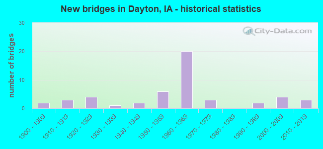
- New bridges - historical statistics
- 21900-1909
- 31910-1919
- 41920-1929
- 11930-1939
- 21940-1949
- 61950-1959
- 201960-1969
- 31970-1979
- 21990-1999
- 42000-2009
- 32010-2019

- Reconstructed bridges - Historical Statistics
- 11960-1969
- 41970-1979
- 41980-1989
- 11990-1999


- Bridge Condition - Deck
- 13.5%Very good
- 13.5%Good
- 18.9%Satisfactory
- 43.2%Fair
- 2.7%Poor
- 5.4%Serious
- 2.7%Failed

- Bridge Condition - Superstructure
- 16.2%Very good
- 13.5%Good
- 21.6%Satisfactory
- 40.5%Fair
- 5.4%Poor
- 2.7%Failed

- Bridge Condition - Substructure
- 16.2%Very good
- 16.2%Good
- 29.7%Satisfactory
- 21.6%Fair
- 10.8%Poor
- 2.7%Serious
- 2.7%Failed

- Bridge Condition - Channel
- 19.1%Very good
- 34.0%Good
- 27.7%Satisfactory
- 14.9%Fair
- 2.1%Poor
- 2.1%Serious

- Bridge Condition - Culverts
- 15.4%Very good
- 7.7%Good
- 38.5%Satisfactory
- 7.7%Fair
- 23.1%Poor
- 7.7%Serious
Find on map >> Show street view
Structure Number: 15, Location: 094440104 (Lat: 42.982844, Lng: -96.000594), Route carried "on" structure: City street , Year Built: 1954, Status: Posted for load, Structure Length: 8.41m (27.59ft), Average Daily Traffic: 850 (year 2019), Average Future Daily Traffic: 850 (year 2040), Design Load: H 15, Features Intersected: FLOYD RIVER, Facility Carried by Structure: FM
Minimum Vertical Clearance: 30+ m (98+ ft), Kilometerpoint: 1.024, Lanes on structure: 2, Owner: City or Municipal Highway Agency, Approaching Roadway Width: 10.1m (33.1ft), Skew: 3 degrees, Material/Design: Steel, Design/Construction: Stringer/Multi-beam, Number Of Spans In Main Unit: 4, Length of Maximum Span: 27.7m (90.9ft), Curb-To-Curb Width: 7.3m (24.0ft), Out-to-Out Width: 7.9m (25.9ft)
Condition: Deck: Fair, Superstructure: Poor, Substructure: Poor, Channel: Very good, Operating Rating: 27.9 metric tons, Method Used To Determine Operating Rating: Load Factor (LF) rating reported by rating factor (RF) method using MS18 loading, Inventory Rating: 16.5 metric tons, Method Used To Determine Inventory Rating: Load Factor (LF) rating reported by rating factor (RF) method using MS18 loading, Structural Evaluation: Meets minimum limits, Deck Geometry: Meets minimum limits, Waterway Adequacy: Equal to present desirable criteria, Approach Roadway Alignment: Better than present minimum criteria, Bridge Posting: Required (Relationship of Operating Rating to Maximum Legal Load: 20.0 - 29.9% below), Designated Inspection Frequency: Every 12 months, Inspection Date: December 2020, Deck Structure Type: Concrete Cast-file-Place, Wearing Surface/Protective System: Wearing Surface: Monolithic Concrete
Find on map >> Show street view
Structure Number: 19, Location: A19000665 (Lat: 42.026747, Lng: -93.624694), Route carried "on" structure: City street , Year Built: 1966, Status: Open, Structure Length: 3.66m (12.01ft), Average Daily Traffic: 4,040 (year 2019), Average Future Daily Traffic: 4,040 (year 2040), Design Load: HS 20, Features Intersected: UPRR, Facility Carried by Structure: 6TH ST
Minimum Vertical Clearance: 30+ m (98+ ft), Kilometerpoint: 0.970, Lanes on structure: 2, Owner: City or Municipal Highway Agency, Approaching Roadway Width: 13.7m (44.9ft), Skew: 1 degrees, Material/Design: Concrete continuous, Design/Construction: Slab, Number Of Spans In Main Unit: 5, Length of Maximum Span: 9.1m (29.9ft), Curb or Sidewalk Widths: Left: 1.5m (4.9ft), Right: 1.5m (4.9ft), Curb-To-Curb Width: 14.6m (47.9ft), Out-to-Out Width: 18.3m (60.0ft)
Condition: Deck: Fair, Superstructure: Fair, Substructure: Fair, Operating Rating: 70.1 metric tons, Method Used To Determine Operating Rating: Allowable Stress (AS), Inventory Rating: 42.2 metric tons, Method Used To Determine Inventory Rating: Allowable Stress (AS), Structural Evaluation: Somewhat better than minimum adequacy, Deck Geometry: Superior to present desirable criteria, Underclear: High priority of replacement, Approach Roadway Alignment: Better than present minimum criteria, Length Of Structure Improvement: 15.00m (49.21ft), Designated Inspection Frequency: Every 24 months, Inspection Date: April 2020, Bridge Improvement Cost: $540,000, Roadway Improvement Cost: $108,000, Deck Structure Type: Concrete Cast-file-Place, Wearing Surface/Protective System: Wearing Surface: Monolithic Concrete
Find on map >> Show street view
Structure Number: 24, Location: A75000537 (Lat: 42.008136, Lng: -93.639278), Route carried "on" structure: City street , Year Built: 1960, Status: Open, Structure Length: 1.19m (3.90ft), Average Daily Traffic: 9,600 (year 2019), Average Future Daily Traffic: 9,600 (year 2040), Design Load: H 20, Features Intersected: WORRELL CREEK, Facility Carried by Structure: UNIVERSITY BLVD
Minimum Vertical Clearance: 30+ m (98+ ft), Kilometerpoint: 2.441, Lanes on structure: 5, Owner: City or Municipal Highway Agency, Approaching Roadway Width: 28.0m (91.9ft), Skew: 23 degrees, Material/Design: Concrete, Design/Construction: Culvert, Number Of Spans In Main Unit: 3, Length of Maximum Span: 3.7m (12.1ft)
Condition: Channel: Good, Culverts: Satisfactory, Operating Rating: 29.9 metric tons, Method Used To Determine Operating Rating: Field evaluation and documented engineering judgment, Inventory Rating: 18.1 metric tons, Method Used To Determine Inventory Rating: Field evaluation and documented engineering judgment, Structural Evaluation: Meets minimum limits, Waterway Adequacy: Equal to present minimum criteria, Approach Roadway Alignment: Equal to present desirable criteria, Designated Inspection Frequency: Every 24 months, Inspection Date: April 2020
Find on map >> Show street view
Structure Number: 421, Location: 000000000 (Lat: 42.752369, Lng: -91.676731), Route carried "on" structure: City street , Year Built: 2019, Status: Open, Structure Length: 3.14m (10.30ft), Average Daily Traffic: 70 (year 1989), Average Future Daily Traffic: 70 (year 2041), Design Load: HL 93, Features Intersected: BRUSH CREEK, Facility Carried by Structure: MAIN ST
Minimum Vertical Clearance: 30+ m (98+ ft), Kilometerpoint: 1.741, Lanes on structure: 2, Owner: City or Municipal Highway Agency, Approaching Roadway Width: 7.9m (25.9ft), Skew: 1 degrees, Material/Design: Prestressed concrete, Design/Construction: Stringer/Multi-beam, Number Of Spans In Main Unit: 1, Length of Maximum Span: 30.5m (100.1ft), Curb-To-Curb Width: 9.1m (29.9ft), Out-to-Out Width: 10.1m (33.1ft)
Condition: Deck: Very good, Superstructure: Very good, Substructure: Very good, Channel: Very good, Operating Rating: 61.2 metric tons, Method Used To Determine Operating Rating: Load and Resistance Factor Rating (LRFR) rating reported by rating factor(RF) method using HL-93 loadings, Inventory Rating: 39.5 metric tons, Method Used To Determine Inventory Rating: Load and Resistance Factor Rating (LRFR) rating reported by rating factor(RF) method using HL-93 loadings, Structural Evaluation: Equal to present desirable criteria, Deck Geometry: Better than present minimum criteria, Waterway Adequacy: Superior to present desirable criteria, Approach Roadway Alignment: Equal to present desirable criteria, Designated Inspection Frequency: Every 24 months, Inspection Date: October 2021, Deck Structure Type: Concrete Cast-file-Place, Wearing Surface/Protective System: Wearing Surface: Monolithic Concrete, Deck Protection: Epoxy Coated Reinforcing
Find on map >> Show street view
Structure Number: 662, Location: Bettendorf, IA (Lat: 41.562503, Lng: -90.466764), Route carried "on" structure: City street , Year Built: 2008, Status: Open, Structure Length: 6.47m (21.23ft), Average Daily Traffic: 9,800 (year 2018), Average Future Daily Traffic: 9,800 (year 2041), Design Load: HS 20, Features Intersected: CROW CREEK, Facility Carried by Structure: MIDDLE RD
Minimum Vertical Clearance: 30+ m (98+ ft), Kilometerpoint: 5.551, Lanes on structure: 4, Owner: City or Municipal Highway Agency, Approaching Roadway Width: 16.5m (54.1ft), Skew: 4 degrees, Material/Design: Prestressed concrete, Design/Construction: Stringer/Multi-beam, Number Of Spans In Main Unit: 3, Length of Maximum Span: 22.9m (75.1ft), Curb or Sidewalk Widths: Left: 3.0m (9.8ft), Right: 1.5m (4.9ft), Curb-To-Curb Width: 16.5m (54.1ft), Out-to-Out Width: 22.3m (73.2ft)
Condition: Deck: Good, Superstructure: Very good, Substructure: Very good, Channel: Very good, Operating Rating: 82.4 metric tons, Method Used To Determine Operating Rating: Load Factor (LF), Inventory Rating: 49.3 metric tons, Method Used To Determine Inventory Rating: Load Factor (LF), Structural Evaluation: Equal to present desirable criteria, Deck Geometry: Meets minimum limits, Waterway Adequacy: Equal to present desirable criteria, Approach Roadway Alignment: Equal to present desirable criteria, Designated Inspection Frequency: Every 24 months, Inspection Date: July 2021, Deck Structure Type: Concrete Cast-file-Place, Wearing Surface/Protective System: Wearing Surface: Monolithic Concrete
Find on map >> Show street view
Structure Number: 665, Location: Bettendorf, IA (Lat: 41.604747, Lng: -90.450667), Route carried "on" structure: City street , Year Built: 1946, Status: Posted for load, Structure Length: 0.73m (2.40ft), Average Daily Traffic: 1,760 (year 2018), Average Future Daily Traffic: 1,760 (year 2041), Design Load: H 15, Features Intersected: SPENCER CREEK TRIB, Facility Carried by Structure: INDIANA AVE
Minimum Vertical Clearance: 30+ m (98+ ft), Kilometerpoint: 2.153, Lanes on structure: 2, Owner: City or Municipal Highway Agency, Approaching Roadway Width: 8.5m (27.9ft), Material/Design: Concrete, Design/Construction: Slab, Number Of Spans In Main Unit: 1, Length of Maximum Span: 7.3m (24.0ft), Curb-To-Curb Width: 7.3m (24.0ft), Out-to-Out Width: 8.6m (28.2ft)
Condition: Deck: Good, Superstructure: Good, Substructure: Satisfactory, Channel: Good, Operating Rating: 19.8 metric tons, Method Used To Determine Operating Rating: Load Factor (LF), Inventory Rating: 11.9 metric tons, Method Used To Determine Inventory Rating: Load Factor (LF), Structural Evaluation: High priority of replacement, Deck Geometry: Meets minimum limits, Waterway Adequacy: Equal to present desirable criteria, Approach Roadway Alignment: Equal to present minimum criteria, Bridge Posting: Required (Relationship of Operating Rating to Maximum Legal Load: > 39.9% below), Length Of Structure Improvement: 4.00m (13.12ft), Designated Inspection Frequency: Every 24 months, Inspection Date: July 2021, Bridge Improvement Cost: $75,000, Roadway Improvement Cost: $75,000, Deck Structure Type: Concrete Cast-file-Place, Wearing Surface/Protective System: Wearing Surface: Other
Find on map >> Show street view
Structure Number: 68, Location: Bettendorf, IA (Lat: 41.541850, Lng: -90.498950), Route carried "on" structure: City street , Year Built: 1969, Status: Open, Structure Length: 6.61m (21.69ft), Average Daily Traffic: 5,000 (year 2018), Average Future Daily Traffic: 5,000 (year 2041), Design Load: H 20, Features Intersected: DUCK CREEK, Facility Carried by Structure: 23RD ST
Minimum Vertical Clearance: 30+ m (98+ ft), Kilometerpoint: 1.914, Lanes on structure: 2, Owner: City or Municipal Highway Agency, Approaching Roadway Width: 8.5m (27.9ft), Material/Design: Prestressed concrete, Design/Construction: Stringer/Multi-beam, Number Of Spans In Main Unit: 3, Length of Maximum Span: 24.7m (81.0ft), Curb or Sidewalk Widths: Left: 0.0m, Right: 1.5m (4.9ft), Curb-To-Curb Width: 14.6m (47.9ft), Out-to-Out Width: 16.3m (53.5ft)
Condition: Deck: Satisfactory, Superstructure: Good, Substructure: Good, Channel: Good, Operating Rating: 49.6 metric tons, Method Used To Determine Operating Rating: Load Factor (LF), Inventory Rating: 24.8 metric tons, Method Used To Determine Inventory Rating: Load Factor (LF), Structural Evaluation: Equal to present minimum criteria, Deck Geometry: Superior to present desirable criteria, Waterway Adequacy: Equal to present desirable criteria, Approach Roadway Alignment: Equal to present desirable criteria, Designated Inspection Frequency: Every 24 months, Inspection Date: July 2021, Deck Structure Type: Concrete Cast-file-Place, Wearing Surface/Protective System: Wearing Surface: Monolithic Concrete
Find on map >> Show street view
Structure Number: 731, Location: 000000000 (Lat: 40.964111, Lng: -92.632911), Route carried "on" structure: City street , Year Built: 2000, Status: Open, Structure Length: 4.57m (14.99ft), Average Daily Traffic: 700 (year 2010), Average Future Daily Traffic: 700 (year 2039), Design Load: HS 20, Features Intersected: IMRL RR, Facility Carried by Structure: STATE ST
Minimum Vertical Clearance: 30+ m (98+ ft), Kilometerpoint: 0.525, Lanes on structure: 2, Owner: County Highway Agency, Approaching Roadway Width: 10.4m (34.1ft), Skew: 2 degrees, Material/Design: Concrete continuous, Design/Construction: Slab, Number Of Spans In Main Unit: 3, Length of Maximum Span: 18.0m (59.1ft), Curb or Sidewalk Widths: Left: 0.0m, Right: 1.5m (4.9ft), Curb-To-Curb Width: 8.5m (27.9ft), Out-to-Out Width: 11.3m (37.1ft)
Condition: Deck: Good, Superstructure: Good, Substructure: Good, Operating Rating: 89.8 metric tons, Method Used To Determine Operating Rating: Load Factor (LF), Inventory Rating: 53.8 metric tons, Method Used To Determine Inventory Rating: Load Factor (LF), Structural Evaluation: Better than present minimum criteria, Deck Geometry: Somewhat better than minimum adequacy, Underclear: Equal to present minimum criteria, Approach Roadway Alignment: Better than present minimum criteria, Length Of Structure Improvement: 15.00m (49.21ft), Designated Inspection Frequency: Every 48 months, Inspection Date: June 2019, Bridge Improvement Cost: $15,000, Roadway Improvement Cost: $2,000, Deck Structure Type: Concrete Cast-file-Place, Wearing Surface/Protective System: Wearing Surface: Monolithic Concrete
Find on map >> Show street view
Structure Number: 831, Location: 080142309 (Lat: 41.725747, Lng: -92.444067), Route carried "on" structure: City street , Year Built: 2002, Status: Open, Structure Length: 4.33m (14.21ft), Average Daily Traffic: 2,780 (year 2018), Average Future Daily Traffic: 2,780 (year 2039), Design Load: HS 20, Features Intersected: LITTLE BEAR CREEK, Facility Carried by Structure: CLAY ST
Minimum Vertical Clearance: 30+ m (98+ ft), Kilometerpoint: 0.550, Lanes on structure: 2, Owner: City or Municipal Highway Agency, Approaching Roadway Width: 10.4m (34.1ft), Material/Design: Prestressed concrete, Design/Construction: Stringer/Multi-beam, Number Of Spans In Main Unit: 3, Length of Maximum Span: 15.9m (52.2ft), Curb-To-Curb Width: 9.3m (30.5ft), Out-to-Out Width: 10.1m (33.1ft)
Condition: Deck: Very good, Superstructure: Very good, Substructure: Very good, Channel: Very good, Operating Rating: 40.8 metric tons, Method Used To Determine Operating Rating: Assigned rating based on Load Factor Design (LFD) reported in metric tons, Inventory Rating: 32.7 metric tons, Method Used To Determine Inventory Rating: Assigned rating based on Load Factor Design (LFD) reported in metric tons, Structural Evaluation: Equal to present desirable criteria, Deck Geometry: Meets minimum limits, Waterway Adequacy: Equal to present desirable criteria, Approach Roadway Alignment: Equal to present desirable criteria, Length Of Structure Improvement: 14.20m (46.59ft), Designated Inspection Frequency: Every 48 months, Inspection Date: December 2019, Bridge Improvement Cost: $15,000, Roadway Improvement Cost: $2,000, Deck Structure Type: Concrete Cast-file-Place, Wearing Surface/Protective System: Wearing Surface: Monolithic Concrete, Deck Protection: Epoxy Coated Reinforcing
Find on map >> Show street view
Structure Number: 196, Location: 000000000 (Lat: 42.755131, Lng: -95.554114), Route carried "on" structure: City street , Year Built: 1961, Status: Open, Structure Length: 1.10m (3.61ft), Average Daily Traffic: 3,690 (year 2019), Average Future Daily Traffic: 3,690 (year 2041), Design Load: H 15, Features Intersected: RAILROAD CREEK, Facility Carried by Structure: W BLUFF ST
Minimum Vertical Clearance: 30+ m (98+ ft), Kilometerpoint: 1.141, Lanes on structure: 2, Owner: City or Municipal Highway Agency, Approaching Roadway Width: 9.1m (29.9ft), Material/Design: Concrete, Design/Construction: Slab, Number Of Spans In Main Unit: 1, Length of Maximum Span: 10.1m (33.1ft), Curb or Sidewalk Widths: Left: 1.7m (5.6ft), Right: 1.7m (5.6ft), Curb-To-Curb Width: 9.1m (29.9ft), Out-to-Out Width: 12.6m (41.3ft)
Condition: Deck: Fair, Superstructure: Fair, Substructure: Poor, Channel: Fair, Operating Rating: 34.2 metric tons, Method Used To Determine Operating Rating: Load Factor (LF), Inventory Rating: 20.5 metric tons, Method Used To Determine Inventory Rating: Load Factor (LF), Structural Evaluation: Meets minimum limits, Deck Geometry: Meets minimum limits, Waterway Adequacy: Equal to present minimum criteria, Approach Roadway Alignment: Equal to present desirable criteria, Length Of Structure Improvement: 9.80m (32.15ft), Designated Inspection Frequency: Every 24 months, Inspection Date: June 2021, Bridge Improvement Cost: $150,000, Roadway Improvement Cost: $10,000, Deck Structure Type: Concrete Cast-file-Place, Wearing Surface/Protective System: Wearing Surface: Monolithic Concrete
Find on map >> Show street view
Structure Number: 201, Location: C70000575 (Lat: 40.752636, Lng: -95.037453), Route carried "on" structure: City street , Year Built: 1900, Year Reconstructed: 1991, Status: Posted for load, Structure Length: 3.17m (10.40ft), Average Daily Traffic: 1,140 (year 2016), Average Future Daily Traffic: 1,140 (year 2040), Features Intersected: DRAINAGE, Facility Carried by Structure: N 16TH ST
Minimum Vertical Clearance: 30+ m (98+ ft), Kilometerpoint: 1.571, Lanes on structure: 2, Owner: City or Municipal Highway Agency, Approaching Roadway Width: 8.2m (26.9ft), Material/Design: Steel, Design/Construction: Stringer/Multi-beam, Number Of Spans In Main Unit: 3, Length of Maximum Span: 10.4m (34.1ft), Curb-To-Curb Width: 7.3m (24.0ft), Out-to-Out Width: 7.9m (25.9ft)
Condition: Deck: Poor, Superstructure: Fair, Substructure: Serious, Channel: Satisfactory, Operating Rating: 21.2 metric tons, Method Used To Determine Operating Rating: Field evaluation and documented engineering judgment, Inventory Rating: 12.7 metric tons, Method Used To Determine Inventory Rating: Field evaluation and documented engineering judgment, Structural Evaluation: High priority of corrective action, Deck Geometry: Meets minimum limits, Waterway Adequacy: Equal to present desirable criteria, Approach Roadway Alignment: Equal to present minimum criteria, Bridge Posting: Required (Relationship of Operating Rating to Maximum Legal Load: > 39.9% below), Length Of Structure Improvement: 10.00m (32.81ft), Designated Inspection Frequency: Every 24 months, Inspection Date: June 2020, Bridge Improvement Cost: $150,000, Roadway Improvement Cost: $1,000, Deck Structure Type: Concrete Cast-file-Place, Wearing Surface/Protective System: Wearing Surface: Monolithic Concrete
Find on map >> Show street view
Structure Number: 23, Location: 081061402 (Lat: 41.826347, Lng: -90.230783), Route carried "on" structure: City street , Year Built: 1978, Status: Open, Structure Length: 0.82m (2.69ft), Average Daily Traffic: 2,740 (year 2018), Average Future Daily Traffic: 2,740 (year 2040), Design Load: HS 20, Features Intersected: DRAINAGE, Facility Carried by Structure: S 19TH ST
Minimum Vertical Clearance: 30+ m (98+ ft), Kilometerpoint: 1.218, Lanes on structure: 2, Owner: City or Municipal Highway Agency, Approaching Roadway Width: 15.9m (52.2ft), Skew: 4 degrees, Material/Design: Concrete continuous, Design/Construction: Culvert, Number Of Spans In Main Unit: 2, Length of Maximum Span: 3.7m (12.1ft), Curb-To-Curb Width: 8.6m (28.2ft), Out-to-Out Width: 8.6m (28.2ft)
Condition: Channel: Satisfactory, Culverts: Satisfactory, Operating Rating: 44.1 metric tons, Method Used To Determine Operating Rating: Assigned rating based on Load Factor Design (LFD) reported in metric tons, Inventory Rating: 32.7 metric tons, Method Used To Determine Inventory Rating: Assigned rating based on Load Factor Design (LFD) reported in metric tons, Structural Evaluation: Equal to present minimum criteria, Deck Geometry: Meets minimum limits, Waterway Adequacy: Equal to present minimum criteria, Approach Roadway Alignment: Better than present minimum criteria, Length Of Structure Improvement: 2.70m (8.86ft), Designated Inspection Frequency: Every 24 months, Inspection Date: May 2020, Bridge Improvement Cost: $15,000, Roadway Improvement Cost: $2,000
Find on map >> Show street view
Structure Number: 3451, Location: 086281300 (Lat: 42.258750, Lng: -94.075981), Route carried "on" structure: City street , Year Built: 2005, Status: Open, Structure Length: 2.29m (7.51ft), Average Daily Traffic: 152 (year 1998), Average Future Daily Traffic: 152 (year 2039), Design Load: HS 20, Features Intersected: SKILLET CREEK, Facility Carried by Structure: 3RD AVE SW
Minimum Vertical Clearance: 30+ m (98+ ft), Kilometerpoint: 0.298, Lanes on structure: 2, Owner: City or Municipal Highway Agency, Approaching Roadway Width: 7.3m (24.0ft), Material/Design: Concrete continuous, Design/Construction: Slab, Number Of Spans In Main Unit: 3, Length of Maximum Span: 8.8m (28.9ft), Curb-To-Curb Width: 7.5m (24.6ft), Out-to-Out Width: 8.3m (27.2ft)
Condition: Deck: Very good, Superstructure: Very good, Substructure: Very good, Channel: Very good, Operating Rating: 76.1 metric tons, Method Used To Determine Operating Rating: Load Factor (LF), Inventory Rating: 45.5 metric tons, Method Used To Determine Inventory Rating: Load Factor (LF), Structural Evaluation: Equal to present desirable criteria, Deck Geometry: Somewhat better than minimum adequacy, Waterway Adequacy: Equal to present desirable criteria, Approach Roadway Alignment: Equal to present desirable criteria, Length Of Structure Improvement: 7.50m (24.61ft), Designated Inspection Frequency: Every 48 months, Inspection Date: December 2019, Bridge Improvement Cost: $15,000, Roadway Improvement Cost: $2,000, Deck Structure Type: Concrete Cast-file-Place, Wearing Surface/Protective System: Wearing Surface: Monolithic Concrete
Find on map >> Show street view
Structure Number: 346, Location: 086281400 (Lat: 42.258519, Lng: -94.067122), Route carried "on" structure: City street , Year Built: 1900, Status: Posted for load, Structure Length: 1.19m (3.90ft), Average Daily Traffic: 40 (year 2007), Average Future Daily Traffic: 40 (year 2040), Features Intersected: SKILLET CREEK, Facility Carried by Structure: 4TH AVE SE
Minimum Vertical Clearance: 30+ m (98+ ft), Kilometerpoint: 0.071, Lanes on structure: 2, Owner: City or Municipal Highway Agency, Approaching Roadway Width: 7.0m (23.0ft), Material/Design: Concrete, Design/Construction: Stringer/Multi-beam, Number Of Spans In Main Unit: 1, Length of Maximum Span: 11.6m (38.1ft), Curb-To-Curb Width: 6.1m (20.0ft), Out-to-Out Width: 6.7m (22.0ft)
Condition: Deck: Fair, Superstructure: Fair, Substructure: Fair, Channel: Satisfactory, Operating Rating: 29.1 metric tons, Method Used To Determine Operating Rating: Allowable Stress (AS), Inventory Rating: 13.3 metric tons, Method Used To Determine Inventory Rating: Allowable Stress (AS), Structural Evaluation: Meets minimum limits, Deck Geometry: Somewhat better than minimum adequacy, Waterway Adequacy: Better than present minimum criteria, Approach Roadway Alignment: Equal to present minimum criteria, Bridge Posting: Required (Relationship of Operating Rating to Maximum Legal Load: 0.1 - 9.9% below), Length Of Structure Improvement: 7.00m (22.97ft), Designated Inspection Frequency: Every 24 months, Inspection Date: November 2020, Bridge Improvement Cost: $185,000, Roadway Improvement Cost: $19,000, Deck Structure Type: Concrete Cast-file-Place, Wearing Surface/Protective System: Wearing Surface: Monolithic Concrete
Find on map >> Show street view
Structure Number: 3465, Location: 086281400 (Lat: 42.260644, Lng: -94.075036), Route carried "on" structure: City street , Year Built: 1965, Status: Open, Structure Length: 0.76m (2.49ft), Average Daily Traffic: 390 (year 2003), Average Future Daily Traffic: 390 (year 2041), Design Load: H 20, Features Intersected: SKILLET CREEK, Facility Carried by Structure: FIRST AVE SW
Minimum Vertical Clearance: 30+ m (98+ ft), Kilometerpoint: 0.639, Lanes on structure: 2, Owner: City or Municipal Highway Agency, Approaching Roadway Width: 12.2m (40.0ft), Material/Design: Concrete continuous, Design/Construction: Culvert, Number Of Spans In Main Unit: 2, Length of Maximum Span: 3.7m (12.1ft)
Condition: Channel: Satisfactory, Culverts: Satisfactory, Operating Rating: 30.8 metric tons, Method Used To Determine Operating Rating: Field evaluation and documented engineering judgment, Inventory Rating: 22.7 metric tons, Method Used To Determine Inventory Rating: Field evaluation and documented engineering judgment, Structural Evaluation: Equal to present minimum criteria, Waterway Adequacy: Equal to present desirable criteria, Approach Roadway Alignment: Better than present minimum criteria, Length Of Structure Improvement: 2.50m (8.20ft), Designated Inspection Frequency: Every 24 months, Inspection Date: November 2021, Bridge Improvement Cost: $15,000, Roadway Improvement Cost: $2,000
Find on map >> Show street view
Structure Number: 357, Location: 000000000 (Lat: 43.304961, Lng: -91.780950), Route carried "on" structure: City street , Year Built: 1960, Status: Open, Structure Length: 0.70m (2.30ft), Average Daily Traffic: 580 (year 2017), Average Future Daily Traffic: 580 (year 2042), Design Load: H 20, Features Intersected: DRY RUN CREEK, Facility Carried by Structure: WILLIAM ST-2ND
Minimum Vertical Clearance: 30+ m (98+ ft), Kilometerpoint: 0.388, Lanes on structure: 2, Owner: City or Municipal Highway Agency, Approaching Roadway Width: 11.0m (36.1ft), Material/Design: Concrete, Design/Construction: Culvert, Number Of Spans In Main Unit: 2, Length of Maximum Span: 3.0m (9.8ft), Curb or Sidewalk Widths: Left: 1.2m (3.9ft), Right: 1.2m (3.9ft)
Condition: Channel: Satisfactory, Culverts: Satisfactory, Operating Rating: 31.5 metric tons, Method Used To Determine Operating Rating: Field evaluation and documented engineering judgment, Inventory Rating: 22.5 metric tons, Method Used To Determine Inventory Rating: Field evaluation and documented engineering judgment, Structural Evaluation: Equal to present minimum criteria, Waterway Adequacy: Equal to present desirable criteria, Approach Roadway Alignment: Equal to present desirable criteria, Length Of Structure Improvement: 4.20m (13.78ft), Designated Inspection Frequency: Every 24 months, Inspection Date: January 2022, Bridge Improvement Cost: $63,000, Roadway Improvement Cost: $6,000
Find on map >> Show street view
Structure Number: 422, Location: S. OF W. 32ND ST (Lat: 42.525953, Lng: -90.693283), Route carried "on" structure: City street , Year Built: 1970, Status: Open, Structure Length: 0.70m (2.30ft), Average Daily Traffic: 571 (year 1975), Average Future Daily Traffic: 571 (year 2041), Design Load: HS 20, Features Intersected: BEE BRANCH, Facility Carried by Structure: WILDWOOD DR
Minimum Vertical Clearance: 30+ m (98+ ft), Kilometerpoint: 0.433, Lanes on structure: 2, Owner: City or Municipal Highway Agency, Approaching Roadway Width: 7.3m (24.0ft), Material/Design: Concrete, Design/Construction: Culvert, Number Of Spans In Main Unit: 2, Length of Maximum Span: 2.7m (8.9ft), Curb or Sidewalk Widths: Left: 0.9m (3.0ft), Right: 0.9m (3.0ft)
Condition: Channel: Serious, Culverts: Poor, Operating Rating: 44.1 metric tons, Method Used To Determine Operating Rating: Field evaluation and documented engineering judgment, Inventory Rating: 32.7 metric tons, Method Used To Determine Inventory Rating: Field evaluation and documented engineering judgment, Structural Evaluation: Meets minimum limits, Waterway Adequacy: Equal to present minimum criteria, Approach Roadway Alignment: Equal to present desirable criteria, Designated Inspection Frequency: Every 12 months, Inspection Date: November 2021
Find on map >> Show street view
Structure Number: 434, Location: 3RD ST SW - BEAR CREEK (Lat: 42.478014, Lng: -91.128094), Route carried "on" structure: City street , Year Built: 1966, Status: Open, Structure Length: 3.81m (12.50ft), Average Daily Traffic: 2,960 (year 2001), Average Future Daily Traffic: 2,960 (year 2040), Design Load: H 20, Features Intersected: BEAR CREEK, Facility Carried by Structure: 3RD ST SW
Minimum Vertical Clearance: 30+ m (98+ ft), Kilometerpoint: 0.681, Lanes on structure: 2, Owner: City or Municipal Highway Agency, Approaching Roadway Width: 12.2m (40.0ft), Material/Design: Concrete continuous, Design/Construction: Slab, Number Of Spans In Main Unit: 3, Length of Maximum Span: 14.9m (48.9ft), Curb or Sidewalk Widths: Left: 1.8m (5.9ft), Right: 0.0m, Curb-To-Curb Width: 8.5m (27.9ft), Out-to-Out Width: 11.0m (36.1ft)
Condition: Deck: Satisfactory, Superstructure: Satisfactory, Substructure: Good, Channel: Good, Operating Rating: 39.2 metric tons, Method Used To Determine Operating Rating: Load and Resistance Factor Rating (LRFR) rating reported by rating factor(RF) method using HL-93 loadings, Inventory Rating: 30.5 metric tons, Method Used To Determine Inventory Rating: Load and Resistance Factor Rating (LRFR) rating reported by rating factor(RF) method using HL-93 loadings, Structural Evaluation: Equal to present minimum criteria, Deck Geometry: Meets minimum limits, Waterway Adequacy: Better than present minimum criteria, Approach Roadway Alignment: Equal to present desirable criteria, Length Of Structure Improvement: 12.50m (41.01ft), Designated Inspection Frequency: Every 24 months, Inspection Date: September 2020, Bridge Improvement Cost: $120,000, Roadway Improvement Cost: $80,000, Deck Structure Type: Concrete Cast-file-Place, Wearing Surface/Protective System: Wearing Surface: Low Slump Concrete
Find on map >> Show street view
Structure Number: 453, Location: 073381 (Lat: 41.148206, Lng: -95.165397), Route carried "on" structure: City street , Year Built: 1972, Status: Open, Structure Length: 2.68m (8.79ft), Average Daily Traffic: 530 (year 2016), Average Future Daily Traffic: 530 (year 2041), Design Load: H 20, Features Intersected: COE CREEK, Facility Carried by Structure: ELM ST
Minimum Vertical Clearance: 30+ m (98+ ft), Kilometerpoint: 0.319, Lanes on structure: 2, Owner: County Highway Agency, Approaching Roadway Width: 7.3m (24.0ft), Skew: 1 degrees, Material/Design: Concrete continuous, Design/Construction: Slab, Number Of Spans In Main Unit: 3, Length of Maximum Span: 10.4m (34.1ft), Curb or Sidewalk Widths: Left: 1.2m (3.9ft), Right: 0.0m, Curb-To-Curb Width: 9.1m (29.9ft), Out-to-Out Width: 10.6m (34.8ft)
Condition: Deck: Satisfactory, Superstructure: Satisfactory, Substructure: Satisfactory, Channel: Good, Operating Rating: 48.5 metric tons, Method Used To Determine Operating Rating: Allowable Stress (AS), Inventory Rating: 30.4 metric tons, Method Used To Determine Inventory Rating: Allowable Stress (AS), Structural Evaluation: Equal to present minimum criteria, Deck Geometry: Equal to present minimum criteria, Waterway Adequacy: Better than present minimum criteria, Approach Roadway Alignment: Equal to present minimum criteria, Length Of Structure Improvement: 11.30m (37.07ft), Designated Inspection Frequency: Every 24 months, Inspection Date: May 2021, Bridge Improvement Cost: $305,000, Roadway Improvement Cost: $31,000, Deck Structure Type: Concrete Cast-file-Place, Wearing Surface/Protective System: Wearing Surface: Monolithic Concrete
Find on map >> Show street view
Structure Number: 494, Location: 098243602 (Lat: 43.268817, Lng: -93.634081), Route carried "on" structure: City street , Year Built: 1966, Status: Open, Structure Length: 4.36m (14.30ft), Average Daily Traffic: 3,200 (year 2019), Average Future Daily Traffic: 3,200 (year 2041), Design Load: HS 20, Features Intersected: WINNEBAGO RIVER, Facility Carried by Structure: SECOR AVE
Minimum Vertical Clearance: 30+ m (98+ ft), Kilometerpoint: 0.441, Lanes on structure: 2, Owner: City or Municipal Highway Agency, Approaching Roadway Width: 8.2m (26.9ft), Material/Design: Prestressed concrete, Design/Construction: Stringer/Multi-beam, Number Of Spans In Main Unit: 3, Length of Maximum Span: 17.1m (56.1ft), Curb or Sidewalk Widths: Left: 0.0m, Right: 1.5m (4.9ft), Curb-To-Curb Width: 9.1m (29.9ft), Out-to-Out Width: 11.9m (39.0ft)
Condition: Deck: Fair, Superstructure: Satisfactory, Substructure: Satisfactory, Channel: Good, Operating Rating: 44.1 metric tons, Method Used To Determine Operating Rating: Assigned rating based on Load Factor Design (LFD) reported in metric tons, Inventory Rating: 32.7 metric tons, Method Used To Determine Inventory Rating: Assigned rating based on Load Factor Design (LFD) reported in metric tons, Structural Evaluation: Equal to present minimum criteria, Deck Geometry: Meets minimum limits, Waterway Adequacy: Better than present minimum criteria, Approach Roadway Alignment: Equal to present minimum criteria, Length Of Structure Improvement: 17.20m (56.43ft), Designated Inspection Frequency: Every 24 months, Inspection Date: March 2021, Bridge Improvement Cost: $258,000, Roadway Improvement Cost: $26,000, Deck Structure Type: Concrete Cast-file-Place, Wearing Surface/Protective System: Wearing Surface: Bituminous
Find on map >> Show street view
Structure Number: 62, Location: 087401404 (Lat: 42.347392, Lng: -95.469819), Route carried "on" structure: City street , Year Built: 1965, Status: Closed, Structure Length: 4.66m (15.29ft), Average Daily Traffic: 5,090 (year 2019), Average Future Daily Traffic: 5,090 (year 2042), Design Load: H 15, Features Intersected: ODEBOLT CREEK, Facility Carried by Structure: MOOREHEAD AVE
Minimum Vertical Clearance: 30+ m (98+ ft), Kilometerpoint: 0.216, Lanes on structure: 4, Owner: City or Municipal Highway Agency, Approaching Roadway Width: 13.1m (43.0ft), Material/Design: Steel continuous, Design/Construction: Stringer/Multi-beam, Number Of Spans In Main Unit: 3, Length of Maximum Span: 17.7m (58.1ft), Curb or Sidewalk Widths: Left: 1.5m (4.9ft), Right: 1.5m (4.9ft), Curb-To-Curb Width: 12.2m (40.0ft), Out-to-Out Width: 15.7m (51.5ft)
Condition: Deck: Failed, Superstructure: Failed, Substructure: Failed, Channel: Fair, Waterway Adequacy: Equal to present minimum criteria, Approach Roadway Alignment: Better than present minimum criteria, Bridge Posting: Required (Relationship of Operating Rating to Maximum Legal Load: > 39.9% below), Length Of Structure Improvement: 18.40m (60.37ft), Designated Inspection Frequency: Every 12 months, Inspection Date: Febuary 2022, Bridge Improvement Cost: $810,000, Roadway Improvement Cost: $81,000, Deck Structure Type: Concrete Cast-file-Place, Wearing Surface/Protective System: Wearing Surface: Monolithic Concrete
Find on map >> Show street view
Structure Number: 622, Location: T88N-R9W-S04-N90.9-E87.3 (Lat: 42.467642, Lng: -91.894406), Route carried "on" structure: City street , Year Built: 1968, Status: Open, Structure Length: 7.71m (25.30ft), Average Daily Traffic: 3,220 (year 2009), Average Future Daily Traffic: 3,220 (year 2041), Design Load: H 20, Features Intersected: WAPSIPINICON RIVER, Facility Carried by Structure: 2ND ST SW
Minimum Vertical Clearance: 30+ m (98+ ft), Kilometerpoint: 1.191, Lanes on structure: 2, Owner: City or Municipal Highway Agency, Approaching Roadway Width: 11.9m (39.0ft), Material/Design: Steel continuous, Design/Construction: Stringer/Multi-beam, Number Of Spans In Main Unit: 3, Length of Maximum Span: 29.9m (98.1ft), Curb or Sidewalk Widths: Left: 1.8m (5.9ft), Right: 0.0m, Curb-To-Curb Width: 8.6m (28.2ft), Out-to-Out Width: 10.9m (35.8ft)
Condition: Deck: Fair, Superstructure: Satisfactory, Substructure: Good, Channel: Good, Operating Rating: 44.1 metric tons, Method Used To Determine Operating Rating: Load and Resistance Factor Rating (LRFR) rating reported by rating factor(RF) method using HL-93 loadings, Inventory Rating: 34.0 metric tons, Method Used To Determine Inventory Rating: Load and Resistance Factor Rating (LRFR) rating reported by rating factor(RF) method using HL-93 loadings, Structural Evaluation: Equal to present minimum criteria, Deck Geometry: Meets minimum limits, Waterway Adequacy: Equal to present desirable criteria, Approach Roadway Alignment: Equal to present desirable criteria, Length Of Structure Improvement: 25.30m (83.01ft), Designated Inspection Frequency: Every 24 months, Inspection Date: September 2021, Bridge Improvement Cost: $600,000, Roadway Improvement Cost: $50,000, Deck Structure Type: Concrete Cast-file-Place, Wearing Surface/Protective System: Wearing Surface: Monolithic Concrete
Find on map >> Show street view
Structure Number: 624, Location: T89N-R9W-S35-N15.3-E11.8 (Lat: 42.470961, Lng: -91.882258), Route carried "on" structure: City street , Year Built: 1969, Status: Open, Structure Length: 3.05m (10.01ft), Average Daily Traffic: 1,150 (year 2021), Average Future Daily Traffic: 1,150 (year 2041), Design Load: H 20, Features Intersected: MELONE CREEK, Facility Carried by Structure: 3RD ST NE
Minimum Vertical Clearance: 30+ m (98+ ft), Kilometerpoint: 1.051, Lanes on structure: 2, Owner: City or Municipal Highway Agency, Approaching Roadway Width: 9.1m (29.9ft), Material/Design: Concrete continuous, Design/Construction: Slab, Number Of Spans In Main Unit: 3, Length of Maximum Span: 11.9m (39.0ft), Curb or Sidewalk Widths: Left: 1.5m (4.9ft), Right: 0.0m, Curb-To-Curb Width: 8.6m (28.2ft), Out-to-Out Width: 10.6m (34.8ft)
Condition: Deck: Fair, Superstructure: Fair, Substructure: Satisfactory, Channel: Good, Operating Rating: 33.4 metric tons, Method Used To Determine Operating Rating: Load and Resistance Factor Rating (LRFR) rating reported by rating factor(RF) method using HL-93 loadings, Inventory Rating: 25.6 metric tons, Method Used To Determine Inventory Rating: Load and Resistance Factor Rating (LRFR) rating reported by rating factor(RF) method using HL-93 loadings, Structural Evaluation: Somewhat better than minimum adequacy, Deck Geometry: Somewhat better than minimum adequacy, Waterway Adequacy: Equal to present desirable criteria, Approach Roadway Alignment: Equal to present desirable criteria, Designated Inspection Frequency: Every 24 months, Inspection Date: September 2021, Deck Structure Type: Concrete Cast-file-Place, Wearing Surface/Protective System: Wearing Surface: Monolithic Concrete
Find on map >> Show street view
Structure Number: 626, Location: 000000000 (Lat: 41.651103, Lng: -91.532239), Route carried "on" structure: City street , Year Built: 1935, Year Reconstructed: 1982, Status: Open, Structure Length: 1.98m (6.50ft), Average Daily Traffic: 477 (year 1975), Average Future Daily Traffic: 477 (year 2041), Features Intersected: RALSTON CREEK, Facility Carried by Structure: BENTON ST
Minimum Vertical Clearance: 30+ m (98+ ft), Kilometerpoint: 2.123, Lanes on structure: 2, Owner: City or Municipal Highway Agency, Approaching Roadway Width: 8.2m (26.9ft), Material/Design: Concrete, Design/Construction: Culvert, Number Of Spans In Main Unit: 2, Number Of Approach Spans: 2, Length of Maximum Span: 4.9m (16.1ft), Curb or Sidewalk Widths: Left: 1.8m (5.9ft), Right: 2.1m (6.9ft)
Condition: Channel: Satisfactory, Culverts: Serious, Operating Rating: 32.7 metric tons, Method Used To Determine Operating Rating: Load Factor (LF), Inventory Rating: 24.5 metric tons, Method Used To Determine Inventory Rating: Load Factor (LF), Structural Evaluation: High priority of corrective action, Waterway Adequacy: Equal to present minimum criteria, Approach Roadway Alignment: Better than present minimum criteria, Length Of Structure Improvement: 9.00m (29.53ft), Designated Inspection Frequency: Every 24 months, Inspection Date: June 2021, Bridge Improvement Cost: $445,000, Roadway Improvement Cost: $45,000, Deck Structure Type: Concrete Cast-file-Place, Wearing Surface/Protective System: Wearing Surface: Monolithic Concrete
Find on map >> Show street view
Structure Number: 629, Location: 000000000 (Lat: 41.652233, Lng: -91.514928), Route carried "on" structure: City street , Year Built: 1957, Status: Open, Structure Length: 0.67m (2.20ft), Average Daily Traffic: 2,210 (year 2018), Average Future Daily Traffic: 2,210 (year 2041), Design Load: H 20, Features Intersected: RALSTON CREEK S BRANCH, Facility Carried by Structure: SHERIDAN AVE
Minimum Vertical Clearance: 30+ m (98+ ft), Kilometerpoint: 0.513, Lanes on structure: 2, Owner: City or Municipal Highway Agency, Approaching Roadway Width: 7.3m (24.0ft), Skew: 1 degrees, Material/Design: Concrete, Design/Construction: Stringer/Multi-beam, Number Of Spans In Main Unit: 1, Length of Maximum Span: 6.4m (21.0ft), Curb or Sidewalk Widths: Left: 1.8m (5.9ft), Right: 1.8m (5.9ft), Curb-To-Curb Width: 7.3m (24.0ft), Out-to-Out Width: 12.5m (41.0ft)
Condition: Deck: Fair, Superstructure: Fair, Substructure: Satisfactory, Channel: Satisfactory, Operating Rating: 53.4 metric tons, Method Used To Determine Operating Rating: Load Factor (LF), Inventory Rating: 32.0 metric tons, Method Used To Determine Inventory Rating: Load Factor (LF), Structural Evaluation: Somewhat better than minimum adequacy, Deck Geometry: High priority of replacement, Waterway Adequacy: Somewhat better than minimum adequacy, Approach Roadway Alignment: Better than present minimum criteria, Length Of Structure Improvement: 2.20m (7.22ft), Designated Inspection Frequency: Every 24 months, Inspection Date: June 2021, Bridge Improvement Cost: $25,000, Roadway Improvement Cost: $3,000, Deck Structure Type: Concrete Cast-file-Place, Wearing Surface/Protective System: Wearing Surface: Bituminous
Find on map >> Show street view
Structure Number: 661, Location: 000000000 (Lat: 42.517378, Lng: -93.268450), Route carried "on" structure: City street , Year Built: 1922, Year Reconstructed: 1984, Status: Open, Structure Length: 5.49m (18.01ft), Average Daily Traffic: 1,700 (year 2021), Average Future Daily Traffic: 1,700 (year 2041), Design Load: HS 20, Features Intersected: IOWA RIVER, Facility Carried by Structure: RIVER ST
Minimum Vertical Clearance: 30+ m (98+ ft), Kilometerpoint: 0.011, Lanes on structure: 2, Owner: City or Municipal Highway Agency, Approaching Roadway Width: 9.1m (29.9ft), Material/Design: Concrete, Design/Construction: Arch - Deck, Number Of Spans In Main Unit: 1, Length of Maximum Span: 42.7m (140.1ft), Curb or Sidewalk Widths: Left: 1.5m (4.9ft), Right: 1.5m (4.9ft), Curb-To-Curb Width: 9.1m (29.9ft), Out-to-Out Width: 13.7m (44.9ft)
Condition: Deck: Good, Superstructure: Satisfactory, Substructure: Good, Channel: Good, Operating Rating: 44.1 metric tons, Method Used To Determine Operating Rating: Field evaluation and documented engineering judgment, Inventory Rating: 32.7 metric tons, Method Used To Determine Inventory Rating: Field evaluation and documented engineering judgment, Structural Evaluation: Equal to present minimum criteria, Deck Geometry: Somewhat better than minimum adequacy, Waterway Adequacy: Equal to present minimum criteria, Approach Roadway Alignment: Better than present minimum criteria, Length Of Structure Improvement: 21.20m (69.55ft), Designated Inspection Frequency: Every 24 months, Inspection Date: January 2021, Bridge Improvement Cost: $891,000, Roadway Improvement Cost: $89,000, Deck Structure Type: Concrete Cast-file-Place
Find on map >> Show street view
Structure Number: 758, Location: 000000000 (Lat: 41.909139, Lng: -95.068603), Route carried "on" structure: City street , Year Built: 1953, Status: Open, Structure Length: 2.47m (8.10ft), Average Daily Traffic: 670 (year 2004), Average Future Daily Traffic: 670 (year 2040), Design Load: HS 20, Features Intersected: WEST NISHNABOTNA RIVER, Facility Carried by Structure: 3RD ST
Minimum Vertical Clearance: 30+ m (98+ ft), Kilometerpoint: 0.509, Lanes on structure: 2, Owner: City or Municipal Highway Agency, Approaching Roadway Width: 10.4m (34.1ft), Material/Design: Concrete continuous, Design/Construction: Slab, Number Of Spans In Main Unit: 3, Length of Maximum Span: 9.4m (30.8ft), Curb or Sidewalk Widths: Left: 1.5m (4.9ft), Right: 0.0m, Curb-To-Curb Width: 7.4m (24.3ft), Out-to-Out Width: 9.4m (30.8ft)
Condition: Deck: Fair, Superstructure: Fair, Substructure: Satisfactory, Channel: Good, Operating Rating: 31.7 metric tons, Method Used To Determine Operating Rating: Load Factor (LF), Inventory Rating: 19.0 metric tons, Method Used To Determine Inventory Rating: Load Factor (LF), Structural Evaluation: Somewhat better than minimum adequacy, Deck Geometry: Meets minimum limits, Waterway Adequacy: Better than present minimum criteria, Approach Roadway Alignment: Equal to present minimum criteria, Length Of Structure Improvement: 8.10m (26.57ft), Designated Inspection Frequency: Every 24 months, Inspection Date: April 2020, Bridge Improvement Cost: $15,000, Roadway Improvement Cost: $2,000, Deck Structure Type: Concrete Cast-file-Place, Wearing Surface/Protective System: Wearing Surface: Monolithic Concrete
Find on map >> Show street view
Structure Number: 81, Location: 000000000 (Lat: 43.151558, Lng: -93.208625), Route carried "on" structure: City street , Year Built: 1963, Year Reconstructed: 1979, Status: Open, Structure Length: 3.35m (10.99ft), Average Daily Traffic: 7,600 (year 2017), Average Future Daily Traffic: 7,600 (year 2042), Design Load: H 20, Features Intersected: WILLOW CREEK, Facility Carried by Structure: S MONROE AVE
Minimum Vertical Clearance: 30+ m (98+ ft), Kilometerpoint: 3.637, Lanes on structure: 2, Owner: City or Municipal Highway Agency, Approaching Roadway Width: 12.2m (40.0ft), Skew: 2 degrees, Material/Design: Concrete continuous, Design/Construction: Slab, Number Of Spans In Main Unit: 3, Length of Maximum Span: 13.1m (43.0ft), Curb or Sidewalk Widths: Left: 1.5m (4.9ft), Right: 1.5m (4.9ft), Curb-To-Curb Width: 12.2m (40.0ft), Out-to-Out Width: 15.8m (51.8ft)
Condition: Deck: Satisfactory, Superstructure: Fair, Substructure: Good, Channel: Very good, Operating Rating: 41.9 metric tons, Method Used To Determine Operating Rating: Allowable Stress (AS), Inventory Rating: 27.8 metric tons, Method Used To Determine Inventory Rating: Allowable Stress (AS), Structural Evaluation: Somewhat better than minimum adequacy, Deck Geometry: Somewhat better than minimum adequacy, Waterway Adequacy: Equal to present desirable criteria, Approach Roadway Alignment: Equal to present desirable criteria, Designated Inspection Frequency: Every 24 months, Inspection Date: January 2022, Deck Structure Type: Concrete Cast-file-Place, Wearing Surface/Protective System: Wearing Surface: Monolithic Concrete
Find on map >> Show street view
Structure Number: 814, Location: 000000000 (Lat: 43.156361, Lng: -93.190086), Route carried "on" structure: City street , Year Built: 1914, Year Reconstructed: 2003, Status: Open, Structure Length: 3.54m (11.61ft), Average Daily Traffic: 2,280 (year 2021), Average Future Daily Traffic: 2,280 (year 2042), Features Intersected: WINNEBAGO RIVER, Facility Carried by Structure: N CAROLINA AVE
Minimum Vertical Clearance: 30+ m (98+ ft), Kilometerpoint: 0.285, Lanes on structure: 2, Owner: City or Municipal Highway Agency, Approaching Roadway Width: 10.7m (35.1ft), Material/Design: Concrete, Design/Construction: Arch - Deck, Number Of Spans In Main Unit: 2, Length of Maximum Span: 17.1m (56.1ft), Curb or Sidewalk Widths: Left: 1.5m (4.9ft), Right: 1.5m (4.9ft), Curb-To-Curb Width: 10.7m (35.1ft), Out-to-Out Width: 14.9m (48.9ft)
Condition: Deck: Satisfactory, Superstructure: Fair, Substructure: Satisfactory, Channel: Satisfactory, Operating Rating: 44.4 metric tons, Method Used To Determine Operating Rating: Field evaluation and documented engineering judgment, Inventory Rating: 32.7 metric tons, Method Used To Determine Inventory Rating: Field evaluation and documented engineering judgment, Structural Evaluation: Somewhat better than minimum adequacy, Deck Geometry: Somewhat better than minimum adequacy, Waterway Adequacy: Better than present minimum criteria, Approach Roadway Alignment: Equal to present desirable criteria, Designated Inspection Frequency: Every 24 months, Inspection Date: January 2022, Deck Structure Type: Concrete Cast-file-Place, Wearing Surface/Protective System: Wearing Surface: Bituminous
Find on map >> Show street view
Structure Number: 815, Location: 000000000 (Lat: 43.155600, Lng: -93.181397), Route carried "on" structure: City street , Year Built: 1962, Status: Open, Structure Length: 6.64m (21.78ft), Average Daily Traffic: 3,430 (year 2021), Average Future Daily Traffic: 3,430 (year 2042), Design Load: H 20, Features Intersected: WINNEBAGO RIVER, Facility Carried by Structure: N KENTUCKY AVE
Minimum Vertical Clearance: 30+ m (98+ ft), Kilometerpoint: 0.430, Lanes on structure: 2, Owner: City or Municipal Highway Agency, Approaching Roadway Width: 12.2m (40.0ft), Skew: 2 degrees, Material/Design: Prestressed concrete continuous, Design/Construction: Stringer/Multi-beam, Number Of Spans In Main Unit: 3, Length of Maximum Span: 24.4m (80.1ft), Curb or Sidewalk Widths: Left: 1.5m (4.9ft), Right: 1.5m (4.9ft), Curb-To-Curb Width: 12.2m (40.0ft), Out-to-Out Width: 15.8m (51.8ft)
Condition: Deck: Satisfactory, Superstructure: Satisfactory, Substructure: Satisfactory, Channel: Good, Operating Rating: 69.2 metric tons, Method Used To Determine Operating Rating: Allowable Stress (AS), Inventory Rating: 26.9 metric tons, Method Used To Determine Inventory Rating: Allowable Stress (AS), Structural Evaluation: Equal to present minimum criteria, Deck Geometry: Equal to present minimum criteria, Waterway Adequacy: Equal to present desirable criteria, Approach Roadway Alignment: Equal to present desirable criteria, Designated Inspection Frequency: Every 24 months, Inspection Date: January 2022, Deck Structure Type: Concrete Cast-file-Place, Wearing Surface/Protective System: Wearing Surface: Monolithic Concrete
Find on map >> Show street view
Structure Number: 816, Location: I65100520 (Lat: 42.481531, Lng: -91.595189), Route carried "on" structure: City street , Year Built: 1928, Status: Posted for load-capacity, Structure Length: 2.50m (8.20ft), Average Daily Traffic: 15 (year 2021), Average Future Daily Traffic: 15 (year 2041), Design Load: HS 20, Features Intersected: PRAIRIE CREEK, Facility Carried by Structure: JOHN ST
Minimum Vertical Clearance: 30+ m (98+ ft), Kilometerpoint: 0.130, Lanes on structure: 1, Owner: City or Municipal Highway Agency, Approaching Roadway Width: 7.3m (24.0ft), Material/Design: Steel, Design/Construction: Truss - Thru, Number Of Spans In Main Unit: 1, Length of Maximum Span: 24.4m (80.1ft), Curb-To-Curb Width: 5.4m (17.7ft), Out-to-Out Width: 5.9m (19.4ft)
Condition: Deck: Fair, Superstructure: Fair, Substructure: Fair, Channel: Fair, Operating Rating: 27.9 metric tons, Method Used To Determine Operating Rating: Allowable Stress (AS), Inventory Rating: 15.0 metric tons, Method Used To Determine Inventory Rating: Allowable Stress (AS), Structural Evaluation: Meets minimum limits, Deck Geometry: High priority of corrective action, Waterway Adequacy: Equal to present minimum criteria, Approach Roadway Alignment: Equal to present desirable criteria, Length Of Structure Improvement: 11.20m (36.75ft), Designated Inspection Frequency: Every 24 months, Critical Feature Inspection Frequency: Every 24 months, Inspection Date: March 2021, Critical Feature Inspection Date: March 2021, Bridge Improvement Cost: $200,000, Roadway Improvement Cost: $30,000, Deck Structure Type: Concrete Cast-file-Place, Wearing Surface/Protective System: Wearing Surface: Monolithic Concrete
Find on map >> Show street view
Structure Number: 1, Location: 100453402 (Lat: 43.436683, Lng: -96.155694), Route carried "on" structure: City street , Year Built: 1956, Status: Posted for load, Structure Length: 4.57m (14.99ft), Average Daily Traffic: 660 (year 2019), Average Future Daily Traffic: 660 (year 2040), Design Load: H 15, Features Intersected: TOM CREEK, Facility Carried by Structure: EAST ST
Minimum Vertical Clearance: 30+ m (98+ ft), Kilometerpoint: 0.507, Lanes on structure: 2, Owner: County Highway Agency, Maintenance Responsibility: City or Municipal Highway Agency, Approaching Roadway Width: 9.1m (29.9ft), Skew: 3 degrees, Material/Design: Steel, Design/Construction: Stringer/Multi-beam, Number Of Spans In Main Unit: 4, Length of Maximum Span: 13.1m (43.0ft), Curb-To-Curb Width: 7.3m (24.0ft), Out-to-Out Width: 7.9m (25.9ft)
Condition: Deck: Serious, Superstructure: Fair, Substructure: Poor, Channel: Good, Operating Rating: 24.9 metric tons, Method Used To Determine Operating Rating: Allowable Stress (AS), Inventory Rating: 13.3 metric tons, Method Used To Determine Inventory Rating: Allowable Stress (AS), Structural Evaluation: Meets minimum limits, Deck Geometry: Meets minimum limits, Waterway Adequacy: Better than present minimum criteria, Approach Roadway Alignment: Equal to present minimum criteria, Bridge Posting: Required (Relationship of Operating Rating to Maximum Legal Load: 10.0 - 19.9% below), Length Of Structure Improvement: 18.00m (59.06ft), Designated Inspection Frequency: Every 24 months, Inspection Date: July 2020, Bridge Improvement Cost: $540,000, Roadway Improvement Cost: $54,000, Deck Structure Type: Concrete Cast-file-Place, Wearing Surface/Protective System: Wearing Surface: Bituminous
Find on map >> Show street view
Structure Number: 25, Location: 095152012 (Lat: 43.024153, Lng: -92.640361), Route carried "on" structure: County highway , Year Built: 1927, Year Reconstructed: 1960, Status: Open, Structure Length: 1.25m (4.10ft), Average Daily Traffic: 700 (year 2021), Truck Traffic: 19%, Average Future Daily Traffic: 700 (year 2041), Design Load: H 20, Features Intersected: BLOODY RUN CREEK, Facility Carried by Structure: OLD HWY RD
Minimum Vertical Clearance: 30+ m (98+ ft), Kilometerpoint: 1.614, Lanes on structure: 2, Base Highway Network: Yes, Owner: County Highway Agency, Approaching Roadway Width: 12.2m (40.0ft), Material/Design: Concrete, Design/Construction: Tee Beam, Number Of Spans In Main Unit: 1, Length of Maximum Span: 12.2m (40.0ft), Curb-To-Curb Width: 13.4m (44.0ft), Out-to-Out Width: 14.8m (48.6ft)
Condition: Deck: Serious, Superstructure: Poor, Substructure: Fair, Channel: Satisfactory, Operating Rating: 42.5 metric tons, Method Used To Determine Operating Rating: Allowable Stress (AS), Inventory Rating: 20.7 metric tons, Method Used To Determine Inventory Rating: Allowable Stress (AS), Structural Evaluation: Meets minimum limits, Deck Geometry: Superior to present desirable criteria, Waterway Adequacy: Equal to present minimum criteria, Approach Roadway Alignment: Equal to present minimum criteria, Length Of Structure Improvement: 5.00m (16.40ft), Designated Inspection Frequency: Every 24 months, Inspection Date: March 2021, Bridge Improvement Cost: $15,000, Roadway Improvement Cost: $2,000, Deck Structure Type: Concrete Cast-file-Place, Wearing Surface/Protective System: Wearing Surface: Monolithic Concrete
Find on map >> Show street view
Structure Number: 347, Location: 2.5 mi. S of Jct. IA 9 (Lat: 43.396969, Lng: -96.428906), Route carried "on" structure: State highway 182, Year Built: 1955, Status: Open, Structure Length: 0.98m (3.22ft), Average Daily Traffic: 2,260 (year 2020), Truck Traffic: 15%, Average Future Daily Traffic: 2,260 (year 2041), Design Load: H 15, Features Intersected: STREAM
Minimum Vertical Clearance: 30+ m (98+ ft), Kilometerpoint: 10.561, Lanes on structure: 2, Base Highway Network: Yes, Owner: State Highway Agency, Approaching Roadway Width: 10.4m (34.1ft), Material/Design: Concrete continuous, Design/Construction: Culvert, Number Of Spans In Main Unit: 3, Length of Maximum Span: 3.0m (9.8ft)
Condition: Channel: Good, Culverts: Satisfactory, Operating Rating: 35.0 metric tons, Method Used To Determine Operating Rating: Load Factor (LF), Inventory Rating: 21.0 metric tons, Method Used To Determine Inventory Rating: Load Factor (LF), Structural Evaluation: Somewhat better than minimum adequacy, Waterway Adequacy: Equal to present minimum criteria, Approach Roadway Alignment: Equal to present desirable criteria, Designated Inspection Frequency: Every 24 months, Inspection Date: Febuary 2021
Find on map >> Show street view
Structure Number: 413, Location: AT JUNCTION WITH US 6 (Lat: 41.614653, Lng: -93.776697), Route carried "on" structure: Interstate 80, Year Built: 1958, Year Reconstructed: 1989, Status: Open, Structure Length: 5.30m (17.39ft), Average Daily Traffic: 42,300 (year 2020), Truck Traffic: 18%, Average Future Daily Traffic: 42,300 (year 2041), Design Load: HS 20, Features Intersected: US 6
Minimum Vertical Clearance: 30+ m (98+ ft), Kilometerpoint: 200.796, Lanes on structure: 3, Lanes under structure: 6, Base Highway Network: Yes, Owner: State Highway Agency, Approaching Roadway Width: 20.7m (67.9ft), Material/Design: Steel continuous, Design/Construction: Stringer/Multi-beam, Number Of Spans In Main Unit: 4, Length of Maximum Span: 14.6m (47.9ft), Curb-To-Curb Width: 19.1m (62.7ft), Out-to-Out Width: 20.0m (65.6ft)
Condition: Deck: Good, Superstructure: Good, Substructure: Fair, Operating Rating: 64.8 metric tons, Method Used To Determine Operating Rating: Load Factor (LF), Inventory Rating: 38.9 metric tons, Method Used To Determine Inventory Rating: Load Factor (LF), Structural Evaluation: Somewhat better than minimum adequacy, Deck Geometry: Superior to present desirable criteria, Underclear: High priority of corrective action, Approach Roadway Alignment: Equal to present desirable criteria, Designated Inspection Frequency: Every 24 months, Inspection Date: March 2021, Deck Structure Type: Concrete Cast-file-Place, Wearing Surface/Protective System: Wearing Surface: Monolithic Concrete, Deck Protection: Epoxy Coated Reinforcing
Find on map >> Show street view
Structure Number: 423, Location: 0.2 MILE E OF JCT IA 28 (Lat: 41.592844, Lng: -93.700169), Route carried "on" structure: Interstate 235, Year Built: 1967, Year Reconstructed: 1986, Status: Open, Structure Length: 7.04m (23.10ft), Average Daily Traffic: 46,100 (year 2020), Truck Traffic: 6%, Average Future Daily Traffic: 46,100 (year 2040), Design Load: HS 20, Features Intersected: CUMMINS PARKWAY
Minimum Vertical Clearance: 30+ m (98+ ft), Kilometerpoint: 7.163, Lanes on structure: 4, Lanes under structure: 2, Base Highway Network: Yes, Owner: State Highway Agency, Approaching Roadway Width: 18.3m (60.0ft), Material/Design: Concrete continuous, Design/Construction: Slab, Number Of Spans In Main Unit: 5, Length of Maximum Span: 16.5m (54.1ft), Curb-To-Curb Width: 21.0m (68.9ft), Out-to-Out Width: 22.4m (73.5ft)
Condition: Deck: Satisfactory, Superstructure: Satisfactory, Substructure: Satisfactory, Channel: Very good, Operating Rating: 70.5 metric tons, Method Used To Determine Operating Rating: Load Factor (LF), Inventory Rating: 42.3 metric tons, Method Used To Determine Inventory Rating: Load Factor (LF), Structural Evaluation: Equal to present minimum criteria, Deck Geometry: Better than present minimum criteria, Underclear: High priority of corrective action, Approach Roadway Alignment: Better than present minimum criteria, Designated Inspection Frequency: Every 24 months, Inspection Date: October 2020, Deck Structure Type: Concrete Cast-file-Place, Wearing Surface/Protective System: Wearing Surface: Low Slump Concrete, Deck Protection: Epoxy Coated Reinforcing
Find on map >> Show street view
Structure Number: 455, Location: 5.1 mi. W of Jct. US 59 (Lat: 41.498258, Lng: -95.434428), Route carried "on" structure: Interstate 80, Year Built: 1966, Status: Open, Structure Length: 5.46m (17.91ft), Average Daily Traffic: 10,950 (year 2020), Truck Traffic: 42%, Average Future Daily Traffic: 10,950 (year 2041), Design Load: HS 20, Features Intersected: SILVER CREEK
Minimum Vertical Clearance: 30+ m (98+ ft), Kilometerpoint: 56.317, Lanes on structure: 2, Base Highway Network: Yes, Owner: State Highway Agency, Approaching Roadway Width: 12.2m (40.0ft), Skew: 1 degrees, Material/Design: Prestressed concrete, Design/Construction: Stringer/Multi-beam, Number Of Spans In Main Unit: 3, Length of Maximum Span: 19.8m (65.0ft), Curb-To-Curb Width: 11.9m (39.0ft), Out-to-Out Width: 12.9m (42.3ft)
Condition: Deck: Fair, Superstructure: Good, Substructure: Satisfactory, Channel: Fair, Operating Rating: 82.3 metric tons, Method Used To Determine Operating Rating: Load Factor (LF), Inventory Rating: 40.0 metric tons, Method Used To Determine Inventory Rating: Load Factor (LF), Structural Evaluation: Equal to present minimum criteria, Deck Geometry: Equal to present minimum criteria, Waterway Adequacy: Equal to present minimum criteria, Approach Roadway Alignment: Equal to present desirable criteria, Designated Inspection Frequency: Every 24 months, Inspection Date: May 2021, Deck Structure Type: Concrete Cast-file-Place, Wearing Surface/Protective System: Wearing Surface: Low Slump Concrete
Find on map >> Show street view
Structure Number: 5239, Location: 1.3 mi E of E jct US 169 (Lat: 42.267925, Lng: -94.080503), Route carried "on" structure: State highway 175, Year Built: 1966, Status: Open, Structure Length: 0.76m (2.49ft), Average Daily Traffic: 1,300 (year 2020), Truck Traffic: 8%, Average Future Daily Traffic: 1,300 (year 2041), Design Load: HS 20, Features Intersected: SKILLET CREEK
Minimum Vertical Clearance: 30+ m (98+ ft), Kilometerpoint: 206.606, Lanes on structure: 2, Base Highway Network: Yes, Owner: State Highway Agency, Approaching Roadway Width: 13.4m (44.0ft), Material/Design: Concrete continuous, Design/Construction: Culvert, Number Of Spans In Main Unit: 2, Length of Maximum Span: 3.7m (12.1ft)
Condition: Channel: Satisfactory, Culverts: Good, Operating Rating: 62.2 metric tons, Method Used To Determine Operating Rating: Load Factor (LF), Inventory Rating: 37.3 metric tons, Method Used To Determine Inventory Rating: Load Factor (LF), Structural Evaluation: Better than present minimum criteria, Waterway Adequacy: Equal to present minimum criteria, Approach Roadway Alignment: Equal to present minimum criteria, Designated Inspection Frequency: Every 24 months, Inspection Date: April 2021
Find on map >> Show street view
Structure Number: 52401, Location: 0.3 MI. S. OF P73 (Lat: 42.258106, Lng: -94.067650), Route carried "on" structure: State highway 175, Year Built: 2018, Status: Open, Structure Length: 0.66m (2.17ft), Average Daily Traffic: 950 (year 2020), Truck Traffic: 10%, Average Future Daily Traffic: 950 (year 2040), Design Load: HL 93, Features Intersected: SKILLET CREEK
Minimum Vertical Clearance: 30+ m (98+ ft), Kilometerpoint: 208.603, Lanes on structure: 2, Base Highway Network: Yes, Owner: State Highway Agency, Approaching Roadway Width: 9.6m (31.5ft), Material/Design: Concrete, Design/Construction: Culvert, Number Of Spans In Main Unit: 2, Length of Maximum Span: 3.0m (9.8ft)
Condition: Channel: Very good, Culverts: Very good, Structural Evaluation: Equal to present desirable criteria, Waterway Adequacy: Superior to present desirable criteria, Approach Roadway Alignment: Equal to present desirable criteria, Designated Inspection Frequency: Every 24 months, Inspection Date: April 2020
Find on map >> Show street view
Structure Number: 625, Location: 098052701 (Lat: 43.283436, Lng: -91.427222), Route carried "on" structure: County highway , Year Built: 1966, Status: Open, Structure Length: 1.40m (4.59ft), Average Daily Traffic: 160 (year 2017), Average Future Daily Traffic: 160 (year 2040), Features Intersected: VILLAGE CREEK, Facility Carried by Structure: LOCAL
Minimum Vertical Clearance: 30+ m (98+ ft), Kilometerpoint: 3.484, Lanes on structure: 2, Owner: County Highway Agency, Approaching Roadway Width: 9.1m (29.9ft), Skew: 3 degrees, Material/Design: Concrete continuous, Design/Construction: Culvert, Number Of Spans In Main Unit: 3, Length of Maximum Span: 4.3m (14.1ft)
Condition: Channel: Fair, Culverts: Poor, Operating Rating: 23.2 metric tons, Method Used To Determine Operating Rating: Field evaluation and documented engineering judgment, Inventory Rating: 17.0 metric tons, Method Used To Determine Inventory Rating: Field evaluation and documented engineering judgment, Structural Evaluation: Meets minimum limits, Waterway Adequacy: Equal to present minimum criteria, Approach Roadway Alignment: Equal to present minimum criteria, Designated Inspection Frequency: Every 24 months, Inspection Date: April 2020