Bridge Statistics for Decatur, Illinois (IL)
Condition, Traffic, Stress, Structural Evaluation, Project Costs
- National Bridge Inventory (NBI) Statistics
- 157Number of bridges
- 1,893ft / 577mTotal length
- $33,994,000Total costs
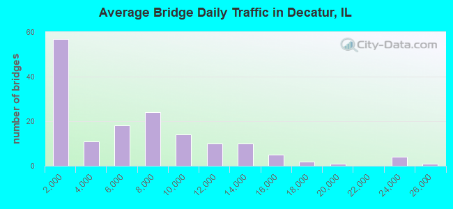
- 927,425Total average daily traffic
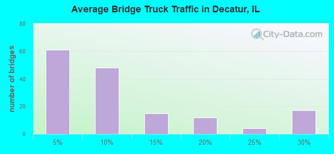
- 94,922Total average daily truck traffic
- National Bridge Inventory (NBI) Registered Bridges for Decatur
- No street view available for this location
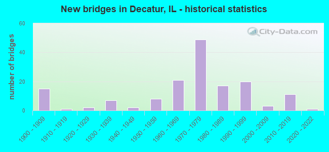
- New bridges - historical statistics
- 151900-1909
- 11910-1919
- 21920-1929
- 71930-1939
- 21940-1949
- 81950-1959
- 211960-1969
- 491970-1979
- 171980-1989
- 201990-1999
- 32000-2009
- 112010-2019
- 12020-2022
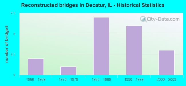
- Reconstructed bridges - Historical Statistics
- 21960-1969
- 11970-1979
- 71980-1989
- 61990-1999
- 32000-2009
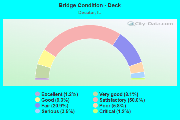
- Bridge Condition - Deck
- 1.2%Excellent
- 8.1%Very good
- 9.3%Good
- 50.0%Satisfactory
- 20.9%Fair
- 5.8%Poor
- 3.5%Serious
- 1.2%Critical
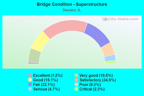
- Bridge Condition - Superstructure
- 1.2%Excellent
- 10.5%Very good
- 15.1%Good
- 34.9%Satisfactory
- 22.1%Fair
- 9.3%Poor
- 4.7%Serious
- 2.3%Critical
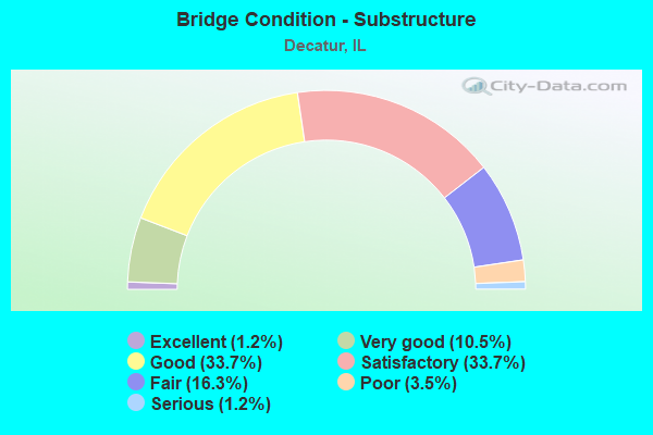
- Bridge Condition - Substructure
- 1.2%Excellent
- 10.5%Very good
- 33.7%Good
- 33.7%Satisfactory
- 16.3%Fair
- 3.5%Poor
- 1.2%Serious
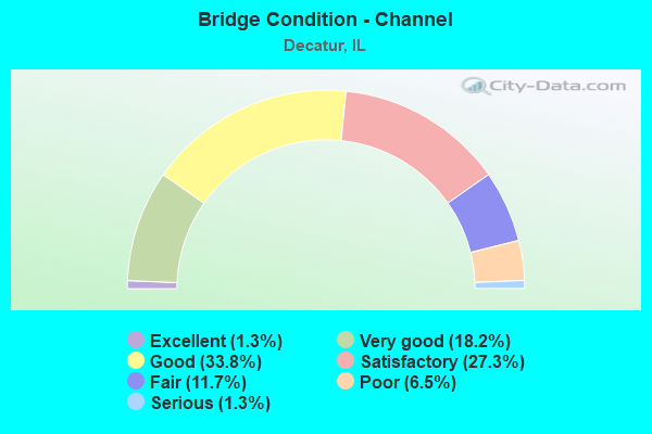
- Bridge Condition - Channel
- 1.3%Excellent
- 18.2%Very good
- 33.8%Good
- 27.3%Satisfactory
- 11.7%Fair
- 6.5%Poor
- 1.3%Serious
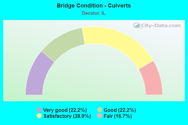
- Bridge Condition - Culverts
- 22.2%Very good
- 22.2%Good
- 38.9%Satisfactory
- 16.7%Fair
Find on map >> Show street view
Structure Number: 583332, Location: 3.1 MI N OF OAKLEY (Lat: 39.922325, Lng: -88.803139), Route carried "on" structure: Other road , Year Built: 1995, Status: Open, Structure Length: 8.54m (28.02ft), Average Daily Traffic: 1,100 (year 2020), Truck Traffic: 5%, Average Future Daily Traffic: 773 (year 2032), Design Load: HS 20, Features Intersected: SANGAMON R OVERFLOW, Facility Carried by Structure: FAU 7454(CH 25)
Minimum Vertical Clearance: 30+ m (98+ ft), Kilometerpoint: 0.161, Lanes on structure: 2, Owner: County Highway Agency, Approaching Roadway Width: 6.7m (22.0ft), Material/Design: Prestressed concrete, Design/Construction: Box Beam or Girders - Multiple, Number Of Spans In Main Unit: 5, Length of Maximum Span: 17.1m (56.1ft), Curb-To-Curb Width: 9.1m (29.9ft), Out-to-Out Width: 9.1m (29.9ft)
Condition: Deck: Fair, Superstructure: Fair, Substructure: Poor, Channel: Satisfactory, Operating Rating: 44.1 metric tons, Method Used To Determine Operating Rating: Assigned rating based on Load Factor Design (LFD) reported by rating factor (RF) using MS18 loading, Inventory Rating: 32.4 metric tons, Method Used To Determine Inventory Rating: Assigned rating based on Load Factor Design (LFD) reported by rating factor (RF) using MS18 loading, Structural Evaluation: Meets minimum limits, Deck Geometry: Somewhat better than minimum adequacy, Waterway Adequacy: Equal to present minimum criteria, Approach Roadway Alignment: Equal to present desirable criteria, Designated Inspection Frequency: Every 24 months, Inspection Date: March 2021, Deck Structure Type: Concrete Precast Panels, Wearing Surface/Protective System: Wearing Surface: Bituminous, Membrane: Built-up
Find on map >> Show street view
Structure Number: 583342, Location: SW EDGE OF DECATUR (Lat: 39.797433, Lng: -89.019708), Route carried "on" structure: County highway , Year Built: 2000, Status: Open, Structure Length: 1.98m (6.50ft), Average Daily Traffic: 650 (year 2020), Truck Traffic: 9%, Average Future Daily Traffic: 928 (year 2032), Design Load: HS 20, Features Intersected: TRIB SANGAMON RIVER, Facility Carried by Structure: FAS 556 (CH 28)
Minimum Vertical Clearance: 30+ m (98+ ft), Kilometerpoint: 11.120, Lanes on structure: 2, Owner: County Highway Agency, Approaching Roadway Width: 6.7m (22.0ft), Skew: 1 degrees, Material/Design: Prestressed concrete, Design/Construction: Box Beam or Girders - Multiple, Number Of Spans In Main Unit: 1, Length of Maximum Span: 19.0m (62.3ft), Curb-To-Curb Width: 10.1m (33.1ft), Out-to-Out Width: 10.1m (33.1ft)
Condition: Deck: Satisfactory, Superstructure: Satisfactory, Substructure: Good, Channel: Good, Operating Rating: 44.1 metric tons, Method Used To Determine Operating Rating: Assigned rating based on Load Factor Design (LFD) reported by rating factor (RF) using MS18 loading, Inventory Rating: 32.4 metric tons, Method Used To Determine Inventory Rating: Assigned rating based on Load Factor Design (LFD) reported by rating factor (RF) using MS18 loading, Structural Evaluation: Equal to present minimum criteria, Deck Geometry: Equal to present minimum criteria, Waterway Adequacy: Equal to present desirable criteria, Approach Roadway Alignment: Equal to present desirable criteria, Designated Inspection Frequency: Every 24 months, Inspection Date: December 2020, Deck Structure Type: Concrete Precast Panels, Wearing Surface/Protective System: Wearing Surface: Bituminous, Membrane: Built-up
Find on map >> Show street view
Structure Number: 583359, Location: 0.8 MI S BEARSDALE (Lat: 39.886458, Lng: -89.011411), Route carried "on" structure: Other road , Year Built: 1909, Year Reconstructed: 2002, Status: Open, Structure Length: 1.69m (5.54ft), Average Daily Traffic: 1,000 (year 2020), Truck Traffic: 6%, Average Future Daily Traffic: 1,031 (year 2032), Design Load: HS 20, Features Intersected: SPRING CREEK, Facility Carried by Structure: FAU 7354(PERSHING
Minimum Vertical Clearance: 30+ m (98+ ft), Kilometerpoint: 2.028, Lanes on structure: 2, Owner: Town or Township Highway Agency, Approaching Roadway Width: 6.8m (22.3ft), Material/Design: Prestressed concrete, Design/Construction: Box Beam or Girders - Multiple, Number Of Spans In Main Unit: 1, Length of Maximum Span: 16.0m (52.5ft), Curb-To-Curb Width: 9.1m (29.9ft), Out-to-Out Width: 9.1m (29.9ft)
Condition: Deck: Satisfactory, Superstructure: Satisfactory, Substructure: Good, Channel: Good, Operating Rating: 60.3 metric tons, Method Used To Determine Operating Rating: Load Factor (LF) rating reported by rating factor (RF) method using MS18 loading, Inventory Rating: 36.0 metric tons, Method Used To Determine Inventory Rating: Load Factor (LF) rating reported by rating factor (RF) method using MS18 loading, Structural Evaluation: Equal to present minimum criteria, Deck Geometry: Equal to present minimum criteria, Waterway Adequacy: Equal to present desirable criteria, Approach Roadway Alignment: Equal to present desirable criteria, Designated Inspection Frequency: Every 24 months, Inspection Date: Febuary 2021, Deck Structure Type: Concrete Precast Panels, Wearing Surface/Protective System: Wearing Surface: Bituminous, Membrane: Built-up
Find on map >> Show street view
Structure Number: 583366, Location: 1.7 MI NE OF OAKLEY (Lat: 39.894483, Lng: -88.783447), Route carried "on" structure: County highway , Year Built: 2010, Status: Open, Structure Length: 1.86m (6.10ft), Average Daily Traffic: 1,350 (year 2020), Truck Traffic: 8%, Average Future Daily Traffic: 1,598 (year 2032), Design Load: HS 25 or greater, Features Intersected: STREAM, Facility Carried by Structure: FAS 1544 (CH 24)
Minimum Vertical Clearance: 30+ m (98+ ft), Kilometerpoint: 7.338, Lanes on structure: 2, Owner: County Highway Agency, Approaching Roadway Width: 9.1m (29.9ft), Material/Design: Prestressed concrete, Design/Construction: Box Beam or Girders - Multiple, Number Of Spans In Main Unit: 1, Length of Maximum Span: 17.8m (58.4ft), Curb-To-Curb Width: 9.8m (32.2ft), Out-to-Out Width: 9.8m (32.2ft)
Condition: Deck: Good, Superstructure: Good, Substructure: Very good, Channel: Good, Operating Rating: 44.1 metric tons, Method Used To Determine Operating Rating: Assigned rating based on Load Factor Design (LFD) reported by rating factor (RF) using MS18 loading, Inventory Rating: 32.4 metric tons, Method Used To Determine Inventory Rating: Assigned rating based on Load Factor Design (LFD) reported by rating factor (RF) using MS18 loading, Structural Evaluation: Better than present minimum criteria, Deck Geometry: Somewhat better than minimum adequacy, Waterway Adequacy: Equal to present desirable criteria, Approach Roadway Alignment: Equal to present desirable criteria, Designated Inspection Frequency: Every 48 months, Inspection Date: January 2020, Deck Structure Type: Concrete Precast Panels, Wearing Surface/Protective System: Wearing Surface: Bituminous, Membrane: Built-up
Find on map >> Show street view
Structure Number: 583381, Location: 2.7 MI N OAKLEY (Lat: 39.912658, Lng: -88.803125), Route carried "on" structure: County highway , Year Built: 2007, Status: Open, Structure Length: 2.00m (6.56ft), Average Daily Traffic: 1,050 (year 2020), Truck Traffic: 9%, Average Future Daily Traffic: 1,289 (year 2032), Design Load: HS 20, Features Intersected: STREAM, Facility Carried by Structure: FAS 544A (CH 25)
Minimum Vertical Clearance: 30+ m (98+ ft), Kilometerpoint: 0.418, Lanes on structure: 2, Owner: County Highway Agency, Approaching Roadway Width: 6.7m (22.0ft), Material/Design: Prestressed concrete, Design/Construction: Box Beam or Girders - Multiple, Number Of Spans In Main Unit: 1, Length of Maximum Span: 19.2m (63.0ft), Curb-To-Curb Width: 8.5m (27.9ft), Out-to-Out Width: 8.5m (27.9ft)
Condition: Deck: Good, Superstructure: Good, Substructure: Good, Channel: Satisfactory, Operating Rating: 44.1 metric tons, Method Used To Determine Operating Rating: Assigned rating based on Load Factor Design (LFD) reported by rating factor (RF) using MS18 loading, Inventory Rating: 32.4 metric tons, Method Used To Determine Inventory Rating: Assigned rating based on Load Factor Design (LFD) reported by rating factor (RF) using MS18 loading, Structural Evaluation: Better than present minimum criteria, Deck Geometry: Somewhat better than minimum adequacy, Waterway Adequacy: Equal to present desirable criteria, Approach Roadway Alignment: Equal to present desirable criteria, Designated Inspection Frequency: Every 48 months, Inspection Date: November 2021, Deck Structure Type: Concrete Precast Panels, Wearing Surface/Protective System: Wearing Surface: Bituminous, Membrane: Built-up
Find on map >> Show street view
Structure Number: 583388, Location: N MT ZION (Lat: 39.797864, Lng: -88.891092), Route carried "on" structure: Other road , Year Built: 2012, Status: Open, Structure Length: 3.70m (12.14ft), Average Daily Traffic: 6,350 (year 2020), Truck Traffic: 4%, Average Future Daily Traffic: 5,567 (year 2032), Design Load: HS 25 or greater, Features Intersected: FINLEY CREEK, Facility Carried by Structure: FAU 7449 (CH 7)
Minimum Vertical Clearance: 30+ m (98+ ft), Kilometerpoint: 2.929, Lanes on structure: 2, Base Highway Network: Yes, Owner: County Highway Agency, Approaching Roadway Width: 35.3m (115.8ft), Material/Design: Prestressed concrete, Design/Construction: Box Beam or Girders - Multiple, Number Of Spans In Main Unit: 3, Length of Maximum Span: 12.2m (40.0ft), Curb or Sidewalk Widths: Left: 0.0m, Right: 4.4m (14.4ft), Curb-To-Curb Width: 9.1m (29.9ft), Out-to-Out Width: 14.7m (48.2ft)
Condition: Deck: Satisfactory, Superstructure: Good, Substructure: Very good, Channel: Good, Operating Rating: 44.1 metric tons, Method Used To Determine Operating Rating: Assigned rating based on Load Factor Design (LFD) reported by rating factor (RF) using MS18 loading, Inventory Rating: 32.4 metric tons, Method Used To Determine Inventory Rating: Assigned rating based on Load Factor Design (LFD) reported by rating factor (RF) using MS18 loading, Structural Evaluation: Better than present minimum criteria, Deck Geometry: High priority of corrective action, Waterway Adequacy: Equal to present desirable criteria, Approach Roadway Alignment: Equal to present desirable criteria, Designated Inspection Frequency: Every 48 months, Inspection Date: Febuary 2019, Deck Structure Type: Concrete Precast Panels, Wearing Surface/Protective System: Wearing Surface: Integral Concrete
Find on map >> Show street view
Structure Number: 585009, Location: MOUND & GREENSWITCH (Lat: 39.892389, Lng: -88.917550), Route carried "on" structure: Other road , Year Built: 1966, Year Reconstructed: 1999, Status: Open, Structure Length: 0.85m (2.79ft), Average Daily Traffic: 2,775 (year 2020), Truck Traffic: 7%, Average Future Daily Traffic: 3,660 (year 2032), Features Intersected: STREAM, Facility Carried by Structure: MOUND RD(FAU 7359)
Minimum Vertical Clearance: 30+ m (98+ ft), Kilometerpoint: 6.968, Lanes on structure: 2, Base Highway Network: Yes, Owner: City or Municipal Highway Agency, Approaching Roadway Width: 7.8m (25.6ft), Skew: 4 degrees, Material/Design: Concrete, Design/Construction: Culvert, Number Of Spans In Main Unit: 2, Length of Maximum Span: 3.9m (12.8ft)
Condition: Channel: Satisfactory, Culverts: Satisfactory, Operating Rating: 40.5 metric tons, Method Used To Determine Operating Rating: Field evaluation and documented engineering judgment, Inventory Rating: 24.3 metric tons, Method Used To Determine Inventory Rating: Field evaluation and documented engineering judgment, Structural Evaluation: Equal to present minimum criteria, Waterway Adequacy: Equal to present minimum criteria, Approach Roadway Alignment: Equal to present desirable criteria, Length Of Structure Improvement: 0.82m (2.69ft), Designated Inspection Frequency: Every 24 months, Inspection Date: May 2021, Bridge Improvement Cost: $298,000, Roadway Improvement Cost: $34,000, Total Project Cost: $332,000
Find on map >> Show street view
Structure Number: 585026, Location: SW OF SOUTHSIDE CC (Lat: 39.793861, Lng: -88.990797), Route carried "on" structure: County highway , Year Built: 1980, Status: Open, Structure Length: 0.73m (2.40ft), Average Daily Traffic: 300 (year 2020), Truck Traffic: 4%, Average Future Daily Traffic: 232 (year 2032), Design Load: HS 20, Features Intersected: WARD BRANCH, Facility Carried by Structure: TR 203(HERITAGE RD
Minimum Vertical Clearance: 30+ m (98+ ft), Kilometerpoint: 0.998, Lanes on structure: 2, Owner: City or Municipal Highway Agency, Approaching Roadway Width: 8.5m (27.9ft), Material/Design: Aluminum, Iron, Design/Construction: Culvert, Number Of Spans In Main Unit: 1, Length of Maximum Span: 6.7m (22.0ft), Curb-To-Curb Width: 8.7m (28.5ft), Out-to-Out Width: 9.3m (30.5ft)
Condition: Channel: Satisfactory, Culverts: Fair, Operating Rating: 32.4 metric tons, Method Used To Determine Operating Rating: Load Factor (LF) rating reported by rating factor (RF) method using MS18 loading, Inventory Rating: 29.2 metric tons, Method Used To Determine Inventory Rating: Load Factor (LF) rating reported by rating factor (RF) method using MS18 loading, Structural Evaluation: Somewhat better than minimum adequacy, Deck Geometry: Equal to present minimum criteria, Waterway Adequacy: Equal to present minimum criteria, Approach Roadway Alignment: Meets minimum limits, Bridge Posting: Required (Relationship of Operating Rating to Maximum Legal Load: 30.0 - 39.9% below), Designated Inspection Frequency: Every 24 months, Inspection Date: December 2020
Find on map >> Show street view
Structure Number: 585027, Location: 1.5 MI S OF OREANA (Lat: 39.915322, Lng: -88.877122), Route carried "on" structure: County highway , Year Built: 1985, Status: Open, Structure Length: 0.95m (3.12ft), Average Daily Traffic: 550 (year 2020), Truck Traffic: 7%, Average Future Daily Traffic: 1,134 (year 2032), Design Load: HS 20, Features Intersected: REYNOLDS RUN, Facility Carried by Structure: TR 55(CUNDIFF RD)
Minimum Vertical Clearance: 30+ m (98+ ft), Kilometerpoint: 1.835, Lanes on structure: 2, Owner: Town or Township Highway Agency, Approaching Roadway Width: 6.1m (20.0ft), Skew: 4 degrees, Material/Design: Concrete, Design/Construction: Culvert, Number Of Spans In Main Unit: 2, Length of Maximum Span: 4.3m (14.1ft)
Condition: Channel: Good, Culverts: Good, Operating Rating: 44.4 metric tons, Method Used To Determine Operating Rating: Assigned rating based on Load Factor Design (LFD) reported by rating factor (RF) using MS18 loading, Inventory Rating: 32.4 metric tons, Method Used To Determine Inventory Rating: Assigned rating based on Load Factor Design (LFD) reported by rating factor (RF) using MS18 loading, Structural Evaluation: Better than present minimum criteria, Waterway Adequacy: Somewhat better than minimum adequacy, Approach Roadway Alignment: Equal to present desirable criteria, Designated Inspection Frequency: Every 48 months, Inspection Date: November 2021
Find on map >> Show street view
Structure Number: 585029, Location: 4 MI S OF ARGENTA (Lat: 39.927111, Lng: -88.827131), Route carried "on" structure: County highway , Year Built: 1962, Status: Open, Structure Length: 0.73m (2.40ft), Average Daily Traffic: 550 (year 2020), Truck Traffic: 1%, Average Future Daily Traffic: 773 (year 2032), Design Load: HS 15, Features Intersected: STREAM, Facility Carried by Structure: TR 45 Kirby Rd
Minimum Vertical Clearance: 30+ m (98+ ft), Kilometerpoint: 0.853, Lanes on structure: 2, Owner: Town or Township Highway Agency, Approaching Roadway Width: 7.6m (24.9ft), Skew: 2 degrees, Material/Design: Concrete continuous, Design/Construction: Culvert, Number Of Spans In Main Unit: 2, Length of Maximum Span: 3.5m (11.5ft), Curb-To-Curb Width: 7.6m (24.9ft), Out-to-Out Width: 7.6m (24.9ft)
Condition: Channel: Satisfactory, Culverts: Fair, Operating Rating: 34.7 metric tons, Method Used To Determine Operating Rating: Load Factor (LF) rating reported by rating factor (RF) method using MS18 loading, Inventory Rating: 20.7 metric tons, Method Used To Determine Inventory Rating: Load Factor (LF) rating reported by rating factor (RF) method using MS18 loading, Structural Evaluation: Somewhat better than minimum adequacy, Deck Geometry: Meets minimum limits, Waterway Adequacy: Meets minimum limits, Approach Roadway Alignment: Equal to present minimum criteria, Designated Inspection Frequency: Every 24 months, Inspection Date: January 2021
Find on map >> Show street view
Structure Number: 585035, Location: 2 MI N OF OAKLEY (Lat: 39.909094, Lng: -88.800108), Route carried "on" structure: County highway , Year Built: 1992, Status: Open, Structure Length: 0.82m (2.69ft), Average Daily Traffic: 125 (year 2020), Truck Traffic: 3%, Average Future Daily Traffic: 77 (year 2032), Design Load: HS 20, Features Intersected: STREAM, Facility Carried by Structure: TR 65A
Minimum Vertical Clearance: 30+ m (98+ ft), Kilometerpoint: 0.274, Lanes on structure: 2, Owner: Town or Township Highway Agency, Approaching Roadway Width: 7.3m (24.0ft), Skew: 1 degrees, Material/Design: Concrete, Design/Construction: Culvert, Number Of Spans In Main Unit: 2, Length of Maximum Span: 3.7m (12.1ft)
Condition: Channel: Satisfactory, Culverts: Satisfactory, Operating Rating: 44.1 metric tons, Method Used To Determine Operating Rating: Assigned rating based on Load Factor Design (LFD) reported by rating factor (RF) using MS18 loading, Inventory Rating: 32.4 metric tons, Method Used To Determine Inventory Rating: Assigned rating based on Load Factor Design (LFD) reported by rating factor (RF) using MS18 loading, Structural Evaluation: Equal to present minimum criteria, Waterway Adequacy: Equal to present minimum criteria, Approach Roadway Alignment: Equal to present desirable criteria, Designated Inspection Frequency: Every 24 months, Inspection Date: January 2021, Wearing Surface/Protective System: Wearing Surface: Bituminous
Find on map >> Show street view
Structure Number: 585059, Location: 3.5 Mi. SE Warr (Lat: 39.906819, Lng: -89.028836), Route carried "on" structure: County highway , Year Built: 2014, Status: Open, Structure Length: 0.97m (3.18ft), Average Daily Traffic: 900 (year 2020), Truck Traffic: 13%, Average Future Daily Traffic: 770 (year 2032), Design Load: HS 25 or greater, Features Intersected: STREAM, Facility Carried by Structure: FAS 1538/WYCKLES R
Minimum Vertical Clearance: 30+ m (98+ ft), Kilometerpoint: 2.961, Lanes on structure: 2, Owner: County Highway Agency, Approaching Roadway Width: 10.1m (33.1ft), Skew: 2 degrees, Material/Design: Concrete, Design/Construction: Culvert, Number Of Spans In Main Unit: 4, Length of Maximum Span: 2.4m (7.9ft), Curb-To-Curb Width: 10.1m (33.1ft)
Condition: Channel: Very good, Culverts: Good, Operating Rating: 42.1 metric tons, Method Used To Determine Operating Rating: Assigned ratings based on Load and Resistance Factor Design (LRFD) reported by rating factor (RF) using HL93 loadings, Inventory Rating: 32.4 metric tons, Method Used To Determine Inventory Rating: Assigned ratings based on Load and Resistance Factor Design (LRFD) reported by rating factor (RF) using HL93 loadings, Structural Evaluation: Better than present minimum criteria, Deck Geometry: Equal to present minimum criteria, Waterway Adequacy: Equal to present desirable criteria, Approach Roadway Alignment: Equal to present desirable criteria, Designated Inspection Frequency: Every 48 months, Inspection Date: January 2020
Find on map >> Show street view
Structure Number: 585065, Location: 4.3 Miles North East (Lat: 39.882344, Lng: -88.873947), Route carried "on" structure: Other road , Year Built: 1986, Status: Open, Structure Length: 0.74m (2.43ft), Average Daily Traffic: 1,950 (year 2020), Truck Traffic: 5%, Average Future Daily Traffic: 2,371 (year 2032), Features Intersected: Lake Decatur Trib, Facility Carried by Structure: FAU 7355 � CH 24
Minimum Vertical Clearance: 30+ m (98+ ft), Kilometerpoint: 5.407, Lanes on structure: 2, Owner: County Highway Agency, Approaching Roadway Width: 7.3m (24.0ft), Skew: 1 degrees, Material/Design: Concrete, Design/Construction: Culvert, Number Of Spans In Main Unit: 3, Length of Maximum Span: 1.9m (6.2ft)
Condition: Channel: Fair, Culverts: Satisfactory, Operating Rating: 53.8 metric tons, Method Used To Determine Operating Rating: Field evaluation and documented engineering judgment, Inventory Rating: 32.4 metric tons, Method Used To Determine Inventory Rating: Field evaluation and documented engineering judgment, Structural Evaluation: Equal to present minimum criteria, Waterway Adequacy: Equal to present desirable criteria, Approach Roadway Alignment: Equal to present desirable criteria, Designated Inspection Frequency: Every 24 months, Inspection Date: April 2020
Find on map >> Show street view
Structure Number: 586001, Location: 1.54 MI E OF US 51 (Lat: 39.862811, Lng: -88.926789), Route carried "on" structure: Other road , Year Built: 1965, Status: Open, Structure Length: 4.22m (13.85ft), Average Daily Traffic: 5,100 (year 2020), Truck Traffic: 7%, Average Future Daily Traffic: 7,011 (year 2032), Design Load: HS 20, Features Intersected: IL 121(FAP 320), Facility Carried by Structure: GARFIELD AV(FAU 73
Minimum Vertical Clearance: 30+ m (98+ ft), Kilometerpoint: 3.122, Lanes on structure: 4, Lanes under structure: 4, Base Highway Network: Yes, Owner: City or Municipal Highway Agency, Approaching Roadway Width: 13.4m (44.0ft), Material/Design: Steel, Design/Construction: Stringer/Multi-beam, Number Of Spans In Main Unit: 3, Length of Maximum Span: 20.4m (66.9ft), Curb or Sidewalk Widths: Left: 0.6m (2.0ft), Right: 0.6m (2.0ft), Curb-To-Curb Width: 13.4m (44.0ft), Out-to-Out Width: 15.5m (50.9ft)
Condition: Deck: Fair, Superstructure: Poor, Substructure: Satisfactory, Operating Rating: 51.5 metric tons, Method Used To Determine Operating Rating: Load Factor (LF) rating reported by rating factor (RF) method using MS18 loading, Inventory Rating: 30.8 metric tons, Method Used To Determine Inventory Rating: Load Factor (LF) rating reported by rating factor (RF) method using MS18 loading, Structural Evaluation: Meets minimum limits, Deck Geometry: High priority of replacement, Underclear: Somewhat better than minimum adequacy, Approach Roadway Alignment: Equal to present desirable criteria, Length Of Structure Improvement: 4.21m (13.81ft), Designated Inspection Frequency: Every 24 months, Other Special Inspection Frequency: Every 48 months, Inspection Date: January 2021, Other Special Inspection Date: January 2021, Bridge Improvement Cost: $2,470,000, Roadway Improvement Cost: $282,000, Total Project Cost: $2,752,000, Deck Structure Type: Concrete Cast-file-Place, Wearing Surface/Protective System: Wearing Surface: Bituminous, Membrane: Built-up
Find on map >> Show street view
Structure Number: 586008, Location: ACROSS SE LAKE DECAT (Lat: 39.820606, Lng: -88.926772), Route carried "on" structure: Other road , Year Built: 1961, Year Reconstructed: 1994, Status: Open, Structure Length: 13.79m (45.24ft), Average Daily Traffic: 8,850 (year 2020), Truck Traffic: 2%, Average Future Daily Traffic: 9,898 (year 2032), Design Load: HS 20, Features Intersected: LAKE DECATUR, Facility Carried by Structure: LOST BRIDGE(FAU 73
Minimum Vertical Clearance: 30+ m (98+ ft), Kilometerpoint: 1.046, Lanes on structure: 2, Base Highway Network: Yes, Owner: County Highway Agency, Approaching Roadway Width: 6.7m (22.0ft), Material/Design: Steel, Design/Construction: Stringer/Multi-beam, Number Of Spans In Main Unit: 6, Length of Maximum Span: 22.5m (73.8ft), Curb or Sidewalk Widths: Left: 0.9m (3.0ft), Right: 0.9m (3.0ft), Curb-To-Curb Width: 9.1m (29.9ft), Out-to-Out Width: 11.5m (37.7ft)
Condition: Deck: Satisfactory, Superstructure: Critical, Substructure: Fair, Channel: Very good, Operating Rating: 63.5 metric tons, Method Used To Determine Operating Rating: Load Factor (LF) rating reported by rating factor (RF) method using MS18 loading, Inventory Rating: 37.9 metric tons, Method Used To Determine Inventory Rating: Load Factor (LF) rating reported by rating factor (RF) method using MS18 loading, Structural Evaluation: High priority of replacement, Deck Geometry: Meets minimum limits, Waterway Adequacy: Superior to present desirable criteria, Approach Roadway Alignment: Equal to present desirable criteria, Designated Inspection Frequency: Every 24 months, Underwater Inspection Frequency: Every 60 months, Inspection Date: August 2020, Underwater Inspection Date: July 2018, Deck Structure Type: Concrete Cast-file-Place, Wearing Surface/Protective System: Wearing Surface: Bituminous, Deck Protection: Epoxy Coated Reinforcing
Find on map >> Show street view
Structure Number: 586009, Location: E SIDE LK DECATUR (Lat: 39.885589, Lng: -88.855347), Route carried "on" structure: City street , Year Built: 1940, Year Reconstructed: 1988, Status: Open, Structure Length: 1.26m (4.13ft), Average Daily Traffic: 200 (year 2020), Truck Traffic: 8%, Average Future Daily Traffic: 412 (year 2032), Design Load: HS 20, Features Intersected: STREAM, Facility Carried by Structure: STAR RTE(MS8050)
Minimum Vertical Clearance: 30+ m (98+ ft), Kilometerpoint: 0.708, Lanes on structure: 1, Owner: City or Municipal Highway Agency, Approaching Roadway Width: 6.7m (22.0ft), Material/Design: Prestressed concrete, Design/Construction: Box Beam or Girders - Multiple, Number Of Spans In Main Unit: 1, Length of Maximum Span: 11.8m (38.7ft), Curb-To-Curb Width: 7.3m (24.0ft), Out-to-Out Width: 7.3m (24.0ft)
Condition: Deck: Good, Superstructure: Good, Substructure: Good, Channel: Good, Operating Rating: 58.0 metric tons, Method Used To Determine Operating Rating: Load Factor (LF) rating reported by rating factor (RF) method using MS18 loading, Inventory Rating: 34.7 metric tons, Method Used To Determine Inventory Rating: Load Factor (LF) rating reported by rating factor (RF) method using MS18 loading, Structural Evaluation: Better than present minimum criteria, Deck Geometry: Somewhat better than minimum adequacy, Waterway Adequacy: Equal to present minimum criteria, Approach Roadway Alignment: Equal to present desirable criteria, Designated Inspection Frequency: Every 24 months, Inspection Date: Febuary 2021, Deck Structure Type: Concrete Precast Panels, Wearing Surface/Protective System: Wearing Surface: Bituminous
Find on map >> Show street view
Structure Number: 58601, Location: 0.9 MI E FRANKLIN (Lat: 39.804481, Lng: -88.937192), Route carried "on" structure: Other road , Year Built: 1909, Year Reconstructed: 1975, Status: Open, Structure Length: 3.10m (10.17ft), Average Daily Traffic: 900 (year 2020), Truck Traffic: 2%, Average Future Daily Traffic: 979 (year 2032), Design Load: HS 15, Features Intersected: SAND CREEK, Facility Carried by Structure: GROVE RD(FAU 7401)
Minimum Vertical Clearance: 30+ m (98+ ft), Kilometerpoint: 1.400, Lanes on structure: 2, Owner: City or Municipal Highway Agency, Approaching Roadway Width: 7.3m (24.0ft), Material/Design: Steel continuous, Design/Construction: Stringer/Multi-beam, Number Of Spans In Main Unit: 3, Length of Maximum Span: 11.0m (36.1ft), Curb-To-Curb Width: 7.3m (24.0ft), Out-to-Out Width: 8.0m (26.2ft)
Condition: Deck: Serious, Superstructure: Fair, Substructure: Very good, Channel: Very good, Operating Rating: 46.7 metric tons, Method Used To Determine Operating Rating: Load Factor (LF) rating reported by rating factor (RF) method using MS18 loading, Inventory Rating: 27.9 metric tons, Method Used To Determine Inventory Rating: Load Factor (LF) rating reported by rating factor (RF) method using MS18 loading, Structural Evaluation: Somewhat better than minimum adequacy, Deck Geometry: Meets minimum limits, Waterway Adequacy: Better than present minimum criteria, Approach Roadway Alignment: Equal to present desirable criteria, Designated Inspection Frequency: Every 24 months, Critical Feature Inspection Frequency: Every 24 months, Inspection Date: June 2019, Critical Feature Inspection Date: June 2019, Deck Structure Type: Concrete Cast-file-Place
Find on map >> Show street view
Structure Number: 586011, Location: 0.14 mi. E. IL 121 (Lat: 39.812911, Lng: -88.874947), Route carried "on" structure: City street , Year Built: 2015, Status: Open, Structure Length: 0.76m (2.49ft), Average Daily Traffic: 200 (year 2020), Truck Traffic: 8%, Average Future Daily Traffic: 550 (year 2040), Design Load: HS 25 or greater, Features Intersected: Creek, Facility Carried by Structure: Decatur Muni 2755
Minimum Vertical Clearance: 30+ m (98+ ft), Kilometerpoint: 0.274, Lanes on structure: 2, Owner: City or Municipal Highway Agency, Approaching Roadway Width: 9.4m (30.8ft), Skew: 4 degrees, Material/Design: Prestressed concrete, Design/Construction: Culvert, Number Of Spans In Main Unit: 2, Length of Maximum Span: 3.7m (12.1ft), Curb or Sidewalk Widths: Left: 0.0m, Right: 1.5m (4.9ft), Curb-To-Curb Width: 9.4m (30.8ft)
Condition: Channel: Very good, Culverts: Good, Operating Rating: 80.7 metric tons, Method Used To Determine Operating Rating: Load and Resistance Factor Rating (LRFR) rating reported by rating factor(RF) method using HL-93 loadings, Inventory Rating: 62.2 metric tons, Method Used To Determine Inventory Rating: Load and Resistance Factor Rating (LRFR) rating reported by rating factor(RF) method using HL-93 loadings, Structural Evaluation: Better than present minimum criteria, Deck Geometry: Equal to present minimum criteria, Waterway Adequacy: Superior to present desirable criteria, Approach Roadway Alignment: Equal to present desirable criteria, Designated Inspection Frequency: Every 48 months, Inspection Date: October 2020, Deck Structure Type: Other
Find on map >> Show street view
Structure Number: 586016, Location: .23 MI S OF GROVE RD (Lat: 39.800258, Lng: -88.982631), Route carried "on" structure: Other road , Year Built: 1985, Status: Open, Structure Length: 0.98m (3.22ft), Average Daily Traffic: 525 (year 2021), Truck Traffic: 5%, Average Future Daily Traffic: 722 (year 2032), Design Load: HS 20, Features Intersected: MORRISON'S CREEK, Facility Carried by Structure: TAYLOR RD(FAU 7426
Minimum Vertical Clearance: 30+ m (98+ ft), Kilometerpoint: 2.398, Lanes on structure: 2, Owner: City or Municipal Highway Agency, Approaching Roadway Width: 7.6m (24.9ft), Skew: 4 degrees, Material/Design: Concrete, Design/Construction: Culvert, Number Of Spans In Main Unit: 2, Length of Maximum Span: 4.5m (14.8ft), Curb-To-Curb Width: 8.1m (26.6ft), Out-to-Out Width: 8.1m (26.6ft)
Condition: Channel: Poor, Culverts: Very good, Operating Rating: 44.4 metric tons, Method Used To Determine Operating Rating: Assigned rating based on Load Factor Design (LFD) reported by rating factor (RF) using MS18 loading, Inventory Rating: 32.4 metric tons, Method Used To Determine Inventory Rating: Assigned rating based on Load Factor Design (LFD) reported by rating factor (RF) using MS18 loading, Structural Evaluation: Equal to present desirable criteria, Deck Geometry: Somewhat better than minimum adequacy, Waterway Adequacy: Equal to present minimum criteria, Approach Roadway Alignment: Equal to present desirable criteria, Designated Inspection Frequency: Every 48 months, Inspection Date: May 2019, Deck Structure Type: Concrete Cast-file-Place, Wearing Surface/Protective System: Wearing Surface: Bituminous
Find on map >> Show street view
Structure Number: 586017, Location: .18 MI S OF GROVE (Lat: 39.800986, Lng: -88.982644), Route carried "on" structure: Other road , Year Built: 1985, Status: Open, Structure Length: 0.73m (2.40ft), Average Daily Traffic: 525 (year 2021), Truck Traffic: 5%, Average Future Daily Traffic: 722 (year 2032), Design Load: HS 20, Features Intersected: MORRISON'S CREEK, Facility Carried by Structure: TAYLOR RD(FAU 7426
Minimum Vertical Clearance: 30+ m (98+ ft), Kilometerpoint: 2.317, Lanes on structure: 2, Owner: City or Municipal Highway Agency, Approaching Roadway Width: 7.6m (24.9ft), Material/Design: Concrete, Design/Construction: Culvert, Number Of Spans In Main Unit: 2, Length of Maximum Span: 3.4m (11.2ft), Curb-To-Curb Width: 8.1m (26.6ft), Out-to-Out Width: 8.1m (26.6ft)
Condition: Channel: Poor, Culverts: Very good, Operating Rating: 44.4 metric tons, Method Used To Determine Operating Rating: Assigned rating based on Load Factor Design (LFD) reported by rating factor (RF) using MS18 loading, Inventory Rating: 32.4 metric tons, Method Used To Determine Inventory Rating: Assigned rating based on Load Factor Design (LFD) reported by rating factor (RF) using MS18 loading, Structural Evaluation: Equal to present desirable criteria, Deck Geometry: Somewhat better than minimum adequacy, Waterway Adequacy: Equal to present minimum criteria, Approach Roadway Alignment: Equal to present desirable criteria, Designated Inspection Frequency: Every 48 months, Inspection Date: May 2019, Deck Structure Type: Concrete Cast-file-Place, Wearing Surface/Protective System: Wearing Surface: Bituminous
Find on map >> Show street view
Structure Number: 586018, Location: .1 MI S OF GROVE RD (Lat: 39.802297, Lng: -88.982669), Route carried "on" structure: Other road , Year Built: 1985, Status: Open, Structure Length: 0.73m (2.40ft), Average Daily Traffic: 525 (year 2021), Truck Traffic: 5%, Average Future Daily Traffic: 722 (year 2032), Design Load: HS 20, Features Intersected: MORRISON'S CREEK, Facility Carried by Structure: TAYLOR RD(FAU 7426
Minimum Vertical Clearance: 30+ m (98+ ft), Kilometerpoint: 2.173, Lanes on structure: 2, Owner: City or Municipal Highway Agency, Approaching Roadway Width: 7.6m (24.9ft), Material/Design: Concrete, Design/Construction: Culvert, Number Of Spans In Main Unit: 2, Length of Maximum Span: 3.4m (11.2ft), Curb-To-Curb Width: 8.1m (26.6ft), Out-to-Out Width: 8.1m (26.6ft)
Condition: Channel: Poor, Culverts: Very good, Operating Rating: 44.4 metric tons, Method Used To Determine Operating Rating: Assigned rating based on Load Factor Design (LFD) reported by rating factor (RF) using MS18 loading, Inventory Rating: 32.4 metric tons, Method Used To Determine Inventory Rating: Assigned rating based on Load Factor Design (LFD) reported by rating factor (RF) using MS18 loading, Structural Evaluation: Equal to present desirable criteria, Deck Geometry: Somewhat better than minimum adequacy, Waterway Adequacy: Equal to present minimum criteria, Approach Roadway Alignment: Equal to present desirable criteria, Designated Inspection Frequency: Every 48 months, Inspection Date: May 2019, Deck Structure Type: Concrete Cast-file-Place, Wearing Surface/Protective System: Wearing Surface: Bituminous
Find on map >> Show street view
Structure Number: 58602, Location: N NE OF DECATUR (Lat: 39.886608, Lng: -88.950325), Route carried "on" structure: Other road , Year Built: 1994, Status: Open, Structure Length: 2.40m (7.87ft), Average Daily Traffic: 7,100 (year 2020), Truck Traffic: 2%, Average Future Daily Traffic: 7,423 (year 2032), Design Load: HS 20, Features Intersected: SPRING CREEK, Facility Carried by Structure: FAU 7437(ML KING D
Minimum Vertical Clearance: 30+ m (98+ ft), Kilometerpoint: 1.336, Lanes on structure: 4, Base Highway Network: Yes, Owner: City or Municipal Highway Agency, Approaching Roadway Width: 14.6m (47.9ft), Skew: 1 degrees, Material/Design: Steel, Design/Construction: Stringer/Multi-beam, Number Of Spans In Main Unit: 1, Length of Maximum Span: 23.2m (76.1ft), Curb or Sidewalk Widths: Left: 0.0m, Right: 1.5m (4.9ft), Curb-To-Curb Width: 15.8m (51.8ft), Out-to-Out Width: 18.1m (59.4ft)
Condition: Deck: Good, Superstructure: Very good, Substructure: Good, Channel: Good, Operating Rating: 44.1 metric tons, Method Used To Determine Operating Rating: Assigned rating based on Load Factor Design (LFD) reported by rating factor (RF) using MS18 loading, Inventory Rating: 32.4 metric tons, Method Used To Determine Inventory Rating: Assigned rating based on Load Factor Design (LFD) reported by rating factor (RF) using MS18 loading, Structural Evaluation: Better than present minimum criteria, Deck Geometry: Meets minimum limits, Waterway Adequacy: Equal to present desirable criteria, Approach Roadway Alignment: Equal to present desirable criteria, Designated Inspection Frequency: Every 48 months, Inspection Date: May 2019, Deck Structure Type: Concrete Cast-file-Place, Wearing Surface/Protective System: Deck Protection: Epoxy Coated Reinforcing
Find on map >> Show street view
Structure Number: 586021, Location: .16 MI W IL 48 N (Lat: 39.877428, Lng: -88.927783), Route carried "on" structure: State highway 48, Year Built: 1981, Status: Open, Structure Length: 1.15m (3.77ft), Average Daily Traffic: 12,000 (year 2021), Truck Traffic: 8%, Average Future Daily Traffic: 18,558 (year 2032), Design Load: HS 20, Features Intersected: DITCH
Minimum Vertical Clearance: 30+ m (98+ ft), Kilometerpoint: 92.680, Lanes on structure: 4, Base Highway Network: Yes, Owner: City or Municipal Highway Agency, Approaching Roadway Width: 14.9m (48.9ft), Skew: 33 degrees, Material/Design: Concrete continuous, Design/Construction: Culvert, Number Of Spans In Main Unit: 3, Length of Maximum Span: 3.7m (12.1ft)
Condition: Channel: Satisfactory, Culverts: Good, Operating Rating: 94.3 metric tons, Method Used To Determine Operating Rating: Load Factor (LF) rating reported by rating factor (RF) method using MS18 loading, Inventory Rating: 56.4 metric tons, Method Used To Determine Inventory Rating: Load Factor (LF) rating reported by rating factor (RF) method using MS18 loading, Structural Evaluation: Better than present minimum criteria, Waterway Adequacy: Equal to present desirable criteria, Approach Roadway Alignment: Superior to present desirable criteria, Designated Inspection Frequency: Every 48 months, Inspection Date: July 2019, Wearing Surface/Protective System: Wearing Surface: Bituminous
Find on map >> Show street view
Structure Number: 586022, Location: NW1/4SEC31-17-3E (Lat: 39.888194, Lng: -88.912356), Route carried "on" structure: City street , Year Built: 1997, Status: Open, Structure Length: 1.10m (3.61ft), Average Daily Traffic: 725 (year 2020), Truck Traffic: 4%, Average Future Daily Traffic: 979 (year 2032), Features Intersected: CATERPILLAR DITCH, Facility Carried by Structure: MEADOWLARK DR
Minimum Vertical Clearance: 30+ m (98+ ft), Kilometerpoint: 0.257, Lanes on structure: 2, Owner: City or Municipal Highway Agency, Approaching Roadway Width: 9.8m (32.2ft), Material/Design: Prestressed concrete, Design/Construction: Box Beam or Girders - Multiple, Number Of Spans In Main Unit: 1, Length of Maximum Span: 11.0m (36.1ft), Curb-To-Curb Width: 9.8m (32.2ft), Out-to-Out Width: 10.1m (33.1ft)
Condition: Deck: Serious, Superstructure: Serious, Substructure: Fair, Channel: Fair, Operating Rating: 22.7 metric tons, Method Used To Determine Operating Rating: Load Factor (LF) rating reported by rating factor (RF) method using MS18 loading, Structural Evaluation: High priority of corrective action, Deck Geometry: Equal to present minimum criteria, Waterway Adequacy: Better than present minimum criteria, Approach Roadway Alignment: Equal to present desirable criteria, Bridge Posting: Required (Relationship of Operating Rating to Maximum Legal Load: > 39.9% below), Designated Inspection Frequency: Every 24 months, Other Special Inspection Frequency: Every 3 months, Inspection Date: July 2021, Other Special Inspection Date: January 2022, Deck Structure Type: Concrete Precast Panels, Wearing Surface/Protective System: Wearing Surface: Bituminous
Find on map >> Show street view
Structure Number: 586024, Location: 1 MI N MT ZION (Lat: 39.803597, Lng: -88.891994), Route carried "on" structure: Other road , Year Built: 2012, Status: Open, Structure Length: 4.60m (15.09ft), Average Daily Traffic: 6,150 (year 2020), Truck Traffic: 3%, Average Future Daily Traffic: 5,980 (year 2032), Design Load: HS 25 or greater, Features Intersected: BIG CREEK, Facility Carried by Structure: BALTIMORE FAU7449
Minimum Vertical Clearance: 30+ m (98+ ft), Kilometerpoint: 2.269, Lanes on structure: 2, Base Highway Network: Yes, Owner: County Highway Agency, Approaching Roadway Width: 9.1m (29.9ft), Material/Design: Prestressed concrete, Design/Construction: Box Beam or Girders - Multiple, Number Of Spans In Main Unit: 1, Length of Maximum Span: 15.1m (49.5ft), Curb-To-Curb Width: 9.1m (29.9ft), Out-to-Out Width: 14.7m (48.2ft)
Condition: Deck: Satisfactory, Superstructure: Good, Substructure: Good, Channel: Good, Operating Rating: 44.1 metric tons, Method Used To Determine Operating Rating: Assigned rating based on Load Factor Design (LFD) reported by rating factor (RF) using MS18 loading, Inventory Rating: 32.4 metric tons, Method Used To Determine Inventory Rating: Assigned rating based on Load Factor Design (LFD) reported by rating factor (RF) using MS18 loading, Structural Evaluation: Better than present minimum criteria, Deck Geometry: High priority of corrective action, Waterway Adequacy: Equal to present desirable criteria, Approach Roadway Alignment: Equal to present desirable criteria, Designated Inspection Frequency: Every 48 months, Inspection Date: Febuary 2019, Deck Structure Type: Concrete Precast Panels, Wearing Surface/Protective System: Wearing Surface: Integral Concrete
Find on map >> Show street view
Structure Number: 586025, Location: .57 MI N OF MOUND RD (Lat: 39.899228, Lng: -88.964561), Route carried "on" structure: Other road , Year Built: 2010, Status: Open, Structure Length: 4.65m (15.26ft), Average Daily Traffic: 4,550 (year 2020), Truck Traffic: 2%, Average Future Daily Traffic: 8,100 (year 2033), Design Load: HS 25 or greater, Features Intersected: STEVENS CREEK, Facility Carried by Structure: FAU 7432
Minimum Vertical Clearance: 30+ m (98+ ft), Kilometerpoint: 0.708, Lanes on structure: 2, Owner: City or Municipal Highway Agency, Approaching Roadway Width: 9.1m (29.9ft), Skew: 1 degrees, Material/Design: Steel continuous, Design/Construction: Stringer/Multi-beam, Number Of Spans In Main Unit: 3, Length of Maximum Span: 17.1m (56.1ft), Curb-To-Curb Width: 9.1m (29.9ft), Out-to-Out Width: 13.4m (44.0ft)
Condition: Deck: Very good, Superstructure: Very good, Substructure: Very good, Channel: Satisfactory, Operating Rating: 44.1 metric tons, Method Used To Determine Operating Rating: Assigned rating based on Load Factor Design (LFD) reported by rating factor (RF) using MS18 loading, Inventory Rating: 32.4 metric tons, Method Used To Determine Inventory Rating: Assigned rating based on Load Factor Design (LFD) reported by rating factor (RF) using MS18 loading, Structural Evaluation: Equal to present desirable criteria, Deck Geometry: Meets minimum limits, Waterway Adequacy: Better than present minimum criteria, Approach Roadway Alignment: Equal to present desirable criteria, Designated Inspection Frequency: Every 48 months, Inspection Date: March 2020, Deck Structure Type: Concrete Cast-file-Place, Wearing Surface/Protective System: Deck Protection: Epoxy Coated Reinforcing
Find on map >> Show street view
Structure Number: 586026, Location: 1.22 MI E OF US 51 (Lat: 39.811731, Lng: -88.933200), Route carried "on" structure: Other road , Year Built: 2013, Status: Open, Structure Length: 4.04m (13.25ft), Average Daily Traffic: 2,950 (year 2020), Truck Traffic: 2%, Average Future Daily Traffic: 2,990 (year 2032), Design Load: HS 25 or greater, Features Intersected: SAND CREEK ARM, Facility Carried by Structure: FAU 7398/S SHORE D
Minimum Vertical Clearance: 30+ m (98+ ft), Kilometerpoint: 2.688, Lanes on structure: 2, Base Highway Network: Yes, Owner: City or Municipal Highway Agency, Approaching Roadway Width: 13.4m (44.0ft), Material/Design: Steel continuous, Design/Construction: Stringer/Multi-beam, Number Of Spans In Main Unit: 2, Length of Maximum Span: 20.2m (66.3ft), Curb-To-Curb Width: 13.4m (44.0ft), Out-to-Out Width: 14.3m (46.9ft)
Condition: Deck: Very good, Superstructure: Very good, Substructure: Very good, Channel: Excellent, Operating Rating: 42.1 metric tons, Method Used To Determine Operating Rating: Assigned ratings based on Load and Resistance Factor Design (LRFD) reported by rating factor (RF) using HL93 loadings, Inventory Rating: 32.4 metric tons, Method Used To Determine Inventory Rating: Assigned ratings based on Load and Resistance Factor Design (LRFD) reported by rating factor (RF) using HL93 loadings, Structural Evaluation: Equal to present desirable criteria, Deck Geometry: Better than present minimum criteria, Waterway Adequacy: Superior to present desirable criteria, Approach Roadway Alignment: Equal to present desirable criteria, Designated Inspection Frequency: Every 48 months, Inspection Date: July 2020, Deck Structure Type: Concrete Cast-file-Place, Wearing Surface/Protective System: Deck Protection: Epoxy Coated Reinforcing
Find on map >> Show street view
Structure Number: 586027, Location: 0.64 MI S OF IL 48 (Lat: 39.811789, Lng: -88.981744), Route carried "on" structure: Other road , Year Built: 2020, Status: Open, Structure Length: 2.94m (9.65ft), Average Daily Traffic: 1,500 (year 2021), Truck Traffic: 4%, Average Future Daily Traffic: 1,701 (year 2032), Design Load: HS 25 or greater, Features Intersected: WARD BRANCH, Facility Carried by Structure: FAU 7426 (TAYLOR R
Minimum Vertical Clearance: 30+ m (98+ ft), Kilometerpoint: 1.030, Lanes on structure: 2, Owner: City or Municipal Highway Agency, Approaching Roadway Width: 9.8m (32.2ft), Skew: 3 degrees, Material/Design: Prestressed concrete, Design/Construction: Stringer/Multi-beam, Number Of Spans In Main Unit: 1, Length of Maximum Span: 28.0m (91.9ft), Curb-To-Curb Width: 9.8m (32.2ft), Out-to-Out Width: 10.7m (35.1ft)
Condition: Deck: Excellent, Superstructure: Excellent, Substructure: Excellent, Channel: Very good, Operating Rating: 55.1 metric tons, Method Used To Determine Operating Rating: Load and Resistance Factor Rating (LRFR) rating reported by rating factor(RF) method using HL-93 loadings, Inventory Rating: 40.8 metric tons, Method Used To Determine Inventory Rating: Load and Resistance Factor Rating (LRFR) rating reported by rating factor(RF) method using HL-93 loadings, Structural Evaluation: Superior to present desirable criteria, Deck Geometry: Somewhat better than minimum adequacy, Waterway Adequacy: Superior to present desirable criteria, Approach Roadway Alignment: Equal to present desirable criteria, Designated Inspection Frequency: Every 24 months, Inspection Date: November 2020, Deck Structure Type: Concrete Cast-file-Place, Wearing Surface/Protective System: Deck Protection: Epoxy Coated Reinforcing
Find on map >> Show street view
Structure Number: 589201, Location: FAIRVIEW PARK (Lat: 39.846431, Lng: -88.992069), Route carried "on" structure: County highway , Year Built: 2012, Status: Open, Structure Length: 3.63m (11.91ft), Average Daily Traffic: 400 (year 2020), Truck Traffic: 1%, Average Future Daily Traffic: 550 (year 2030), Design Load: HS 25 or greater, Features Intersected: STEVENS CREEK, Facility Carried by Structure: TR 939-PARK DR
Minimum Vertical Clearance: 30+ m (98+ ft), Kilometerpoint: 1.577, Lanes on structure: 2, Owner: Local Park, Forest, or Reservation Agency, Approaching Roadway Width: 8.4m (27.6ft), Material/Design: Prestressed concrete, Design/Construction: Box Beam or Girders - Multiple, Number Of Spans In Main Unit: 3, Length of Maximum Span: 20.1m (65.9ft), Curb-To-Curb Width: 8.4m (27.6ft), Out-to-Out Width: 9.1m (29.9ft)
Condition: Deck: Satisfactory, Superstructure: Satisfactory, Substructure: Very good, Channel: Good, Operating Rating: 44.1 metric tons, Method Used To Determine Operating Rating: Assigned rating based on Load Factor Design (LFD) reported by rating factor (RF) using MS18 loading, Inventory Rating: 32.4 metric tons, Method Used To Determine Inventory Rating: Assigned rating based on Load Factor Design (LFD) reported by rating factor (RF) using MS18 loading, Structural Evaluation: Equal to present minimum criteria, Deck Geometry: Somewhat better than minimum adequacy, Waterway Adequacy: Equal to present desirable criteria, Approach Roadway Alignment: Equal to present desirable criteria, Designated Inspection Frequency: Every 24 months, Inspection Date: March 2020, Deck Structure Type: Concrete Precast Panels, Wearing Surface/Protective System: Wearing Surface: Other
Find on map >> Show street view
Structure Number: 580005, Location: ON MAIN ST DECATUR (Lat: 39.847469, Lng: -88.956014), Route carried "under" structure: Other road , Year Built: 1934, Structure Length: 0. m, Average Daily Traffic: 10,100 (year 2021), Truck Traffic: 2%, Features Intersected: US 51(FAP 710), Facility Carried by Structure: N&S RR
Minimum Vertical Clearance: 4.27m (14.01ft), Kilometerpoint: 6.791, Lanes under structure: 4, Material/Design: Steel, Design/Construction: Girder and Floorbeam System, Length of Maximum Span: 17.6m (57.7ft)
Find on map >> Show street view
Structure Number: 580006, Location: S MAIN DECATUR (Lat: 39.832453, Lng: -88.955181), Route carried "under" structure: Other road , Year Built: 1933, Structure Length: 0. m, Average Daily Traffic: 7,600 (year 2020), Truck Traffic: 6%, Features Intersected: US 51(FAP 710), Facility Carried by Structure: IC RR
Minimum Vertical Clearance: 4.93m (16.17ft), Kilometerpoint: 8.481, Lanes under structure: 4, Material/Design: Steel, Design/Construction: Girder and Floorbeam System, Length of Maximum Span: 18.3m (60.0ft)
Find on map >> Show street view
Structure Number: 580007, Location: IN DECATUR (Lat: 39.827678, Lng: -88.953553), Route carried "under" structure: Other road , Year Built: 1962, Structure Length: 0. m, Average Daily Traffic: 1,750 (year 2020), Truck Traffic: 6%, Features Intersected: IL 105(FAP 712), Facility Carried by Structure: US-51 SB (FAP 710)
Minimum Vertical Clearance: 4.52m (14.83ft), Kilometerpoint: 0.306, Lanes on structure: 2, Lanes under structure: 2, Material/Design: Steel continuous, Design/Construction: Stringer/Multi-beam, Length of Maximum Span: 17.5m (57.4ft)
Find on map >> Show street view
Structure Number: 580008, Location: IN DECATUR (Lat: 39.827589, Lng: -88.953064), Route carried "under" structure: State highway 105, Year Built: 1963, Structure Length: 0. m, Average Daily Traffic: 7,950 (year 2021), Truck Traffic: 6%, Features Intersected: IL 105(FAP 712), Facility Carried by Structure: US-51NB (FAP 710AL
Minimum Vertical Clearance: 4.52m (14.83ft), Kilometerpoint: 2.317, Lanes on structure: 2, Lanes under structure: 2, Material/Design: Steel continuous, Design/Construction: Stringer/Multi-beam, Length of Maximum Span: 17.2m (56.4ft)
Find on map >> Show street view
Structure Number: 580011, Location: 1 MI S OF DECATUR (Lat: 39.817414, Lng: -88.963381), Route carried "under" structure: Other road , Year Built: 1959, Structure Length: 0. m, Average Daily Traffic: 9,300 (year 2020), Truck Traffic: 8%, Features Intersected: US 51(FAP 710), Facility Carried by Structure: IC RR
Minimum Vertical Clearance: 4.55m (14.93ft), Kilometerpoint: 10.477, Lanes under structure: 4, Material/Design: Steel, Design/Construction: Girder and Floorbeam System, Length of Maximum Span: 25.6m (84.0ft)
Find on map >> Show street view
Structure Number: 580013, Location: IN DECATUR (Lat: 39.835853, Lng: -88.952850), Route carried "under" structure: Other road , Year Built: 1965, Structure Length: 0. m, Average Daily Traffic: 8,700 (year 2020), Truck Traffic: 2%, Features Intersected: US 51(FAP 710), Facility Carried by Structure: IC RR
Minimum Vertical Clearance: 4.55m (14.93ft), Kilometerpoint: 0.901, Lanes under structure: 4, Material/Design: Steel, Length of Maximum Span: 38.1m (125.0ft)
Find on map >> Show street view
Structure Number: 580014, Location: IN DECATUR (Lat: 39.846939, Lng: -88.953350), Route carried "under" structure: City street , Year Built: 1966, Structure Length: 0. m, Average Daily Traffic: 850 (year 2020), Truck Traffic: 4%, Features Intersected: N&S RR & CERRO GORDO, Facility Carried by Structure: US 51(FAP 710 ALT)
Minimum Vertical Clearance: 5.64m (18.50ft), Kilometerpoint: 0.644, Lanes on structure: 3, Lanes under structure: 2, Material/Design: Steel continuous, Design/Construction: Stringer/Multi-beam, Length of Maximum Span: 24.7m (81.0ft)
Find on map >> Show street view
Structure Number: 580019, Location: IN DECATUR (Lat: 39.836042, Lng: -88.913525), Route carried "under" structure: Other road , Year Built: 1954, Structure Length: 0. m, Average Daily Traffic: 200 (year 2021), Truck Traffic: 5%, Features Intersected: LAKE SHORE DR(U 7390, Facility Carried by Structure: US 36(FAP 320)
Minimum Vertical Clearance: 4.32m (14.17ft), Kilometerpoint: 3.540, Lanes on structure: 4, Lanes under structure: 2, Material/Design: Steel, Design/Construction: Stringer/Multi-beam, Length of Maximum Span: 11.7m (38.4ft)
Find on map >> Show street view
Structure Number: 580025, Location: N OF GARFIELD-DECATR (Lat: 39.862956, Lng: -88.926792), Route carried "under" structure: State highway 121, Year Built: 1943, Structure Length: 0. m, Average Daily Traffic: 14,400 (year 2021), Truck Traffic: 10%, Features Intersected: IL 121(FAP 320), Facility Carried by Structure: IT RR
Minimum Vertical Clearance: 4.39m (14.40ft), Kilometerpoint: 115.596, Lanes under structure: 4, Material/Design: Wood or Timber, Design/Construction: Girder and Floorbeam System, Length of Maximum Span: 15.4m (50.5ft)
Find on map >> Show street view
Structure Number: 580027, Location: SWCL OF DECATUR (Lat: 39.823444, Lng: -88.961281), Route carried "under" structure: State highway 105, Year Built: 1962, Structure Length: 0. m, Average Daily Traffic: 10,500 (year 2021), Truck Traffic: 4%, Features Intersected: FAP 714 (IL 105), Facility Carried by Structure: IC RR
Minimum Vertical Clearance: 4.29m (14.07ft), Kilometerpoint: 1.352, Lanes under structure: 4, Material/Design: Steel, Design/Construction: Stringer/Multi-beam, Length of Maximum Span: 15.9m (52.2ft)
Find on map >> Show street view
Structure Number: 580031, Location: IN DECATUR (Lat: 39.876931, Lng: -88.946250), Route carried "under" structure: State highway 48, Year Built: 1959, Structure Length: 0. m, Average Daily Traffic: 17,800 (year 2021), Truck Traffic: 5%, Features Intersected: PERSHING(FAP 320), Facility Carried by Structure: IC RR
Minimum Vertical Clearance: 4.22m (13.85ft), Kilometerpoint: 91.070, Lanes under structure: 4, Material/Design: Steel, Design/Construction: Stringer/Multi-beam, Length of Maximum Span: 22.1m (72.5ft)
Find on map >> Show street view
Structure Number: 580033, Location: IN DECATUR (Lat: 39.869225, Lng: -88.972950), Route carried "under" structure: State highway 48, Year Built: 1934, Structure Length: 0. m, Average Daily Traffic: 14,500 (year 2021), Truck Traffic: 2%, Features Intersected: OAKLAND(FAU 7429), Facility Carried by Structure: IC RR
Minimum Vertical Clearance: 4.42m (14.50ft), Kilometerpoint: 87.980, Lanes under structure: 4, Material/Design: Steel, Design/Construction: Girder and Floorbeam System, Length of Maximum Span: 16.2m (53.1ft)
Find on map >> Show street view
Structure Number: 580036, Location: IN DECATUR (Lat: 39.831689, Lng: -88.976889), Route carried "under" structure: State highway 48, Year Built: 1900, Structure Length: 0. m, Average Daily Traffic: 9,200 (year 2021), Truck Traffic: 4%, Features Intersected: FAIRVIEW(FAU 7429), Facility Carried by Structure: N&S RR
Minimum Vertical Clearance: 9.04m (29.66ft), Kilometerpoint: 83.651, Lanes under structure: 2, Material/Design: Steel, Design/Construction: Girder and Floorbeam System, Length of Maximum Span: 27.4m (89.9ft)
Find on map >> Show street view
Structure Number: 580054, Location: 1.83 MI S FAS 549 (Lat: 39.909411, Lng: -88.917731), Route carried "under" structure: Interstate 72, Year Built: 1972, Structure Length: 0. m, Average Daily Traffic: 12,000 (year 2021), Truck Traffic: 29%, Features Intersected: I-72, Facility Carried by Structure: TR 150(GREENSWITCH
Minimum Vertical Clearance: 5.00m (16.40ft), Kilometerpoint: 230.870, Lanes on structure: 2, Lanes under structure: 4, Material/Design: Steel continuous, Design/Construction: Stringer/Multi-beam, Length of Maximum Span: 29.5m (96.8ft)
Find on map >> Show street view
Structure Number: 580072, Location: 2 MI N HARRISTOWN (Lat: 39.875389, Lng: -89.028850), Route carried "under" structure: Interstate 72, Year Built: 1976, Structure Length: 0. m, Average Daily Traffic: 13,700 (year 2021), Truck Traffic: 27%, Features Intersected: I-72, Facility Carried by Structure: CH 41(FAS 1538)
Minimum Vertical Clearance: 5.33m (17.49ft), Kilometerpoint: 219.879, Lanes on structure: 2, Lanes under structure: 4, Material/Design: Steel continuous, Design/Construction: Stringer/Multi-beam, Length of Maximum Span: 46.5m (152.6ft)
Find on map >> Show street view
Structure Number: 580073, Location: .5 MI S ILL-121 INT (Lat: 39.890919, Lng: -89.011400), Route carried "under" structure: Interstate 72, Year Built: 1976, Structure Length: 0. m, Average Daily Traffic: 13,700 (year 2021), Truck Traffic: 27%, Features Intersected: I-72, Facility Carried by Structure: FAU 7354 S.ELIZABE
Minimum Vertical Clearance: 5.51m (18.08ft), Kilometerpoint: 222.164, Lanes on structure: 2, Lanes under structure: 4, Material/Design: Steel continuous, Design/Construction: Stringer/Multi-beam, Length of Maximum Span: 45.4m (149.0ft)
Find on map >> Show street view
Structure Number: 580074, Location: 1.5 MI NW DECATUR (Lat: 39.894042, Lng: -89.006533), Route carried "under" structure: State highway 121, Year Built: 1976, Structure Length: 0. m, Average Daily Traffic: 7,900 (year 2021), Truck Traffic: 15%, Features Intersected: FA320/IC RR (IL 121), Facility Carried by Structure: I-72 (EB)
Minimum Vertical Clearance: 7.01m (23.00ft), Kilometerpoint: 124.866, Lanes on structure: 3, Lanes under structure: 4, Material/Design: Steel continuous, Design/Construction: Stringer/Multi-beam, Length of Maximum Span: 37.9m (124.3ft)
Find on map >> Show street view
Structure Number: 580075, Location: 1.5 MI NW DECATUR (Lat: 39.894203, Lng: -89.006789), Route carried "under" structure: State highway 121, Year Built: 1976, Structure Length: 0. m, Average Daily Traffic: 7,900 (year 2021), Truck Traffic: 15%, Features Intersected: FA320/IC RR (IL 121), Facility Carried by Structure: I-72 (WB)
Minimum Vertical Clearance: 7.16m (23.49ft), Kilometerpoint: 124.898, Lanes on structure: 3, Lanes under structure: 4, Material/Design: Steel continuous, Design/Construction: Stringer/Multi-beam, Length of Maximum Span: 37.9m (124.3ft)
Find on map >> Show street view
Structure Number: 580076, Location: N EDGE OF DECATUR (Lat: 39.907561, Lng: -88.974050), Route carried "under" structure: Interstate 72, Year Built: 1976, Structure Length: 0. m, Average Daily Traffic: 13,000 (year 2021), Truck Traffic: 29%, Features Intersected: I-72, Facility Carried by Structure: FAU 7431(OAKLAND A
Minimum Vertical Clearance: 5.03m (16.50ft), Kilometerpoint: 226.058, Lanes on structure: 2, Lanes under structure: 6, Material/Design: Steel continuous, Design/Construction: Stringer/Multi-beam, Length of Maximum Span: 33.8m (110.9ft)
Find on map >> Show street view
Structure Number: 580084, Location: 2.5 MI E FORSYTH (Lat: 39.910117, Lng: -88.894608), Route carried "under" structure: State highway 48, Year Built: 1974, Structure Length: 0. m, Average Daily Traffic: 6,700 (year 2021), Truck Traffic: 22%, Features Intersected: IL 48(FAP 712)IC RR, Facility Carried by Structure: I-72 (EB)
Minimum Vertical Clearance: 6.68m (21.92ft), Kilometerpoint: 97.395, Lanes on structure: 2, Lanes under structure: 4, Material/Design: Steel continuous, Design/Construction: Stringer/Multi-beam, Length of Maximum Span: 26.3m (86.3ft)
Find on map >> Show street view
Structure Number: 580085, Location: 2.5 MI E FORSYTH (Lat: 39.910414, Lng: -88.894325), Route carried "under" structure: State highway 48, Year Built: 1974, Structure Length: 0. m, Average Daily Traffic: 6,700 (year 2021), Truck Traffic: 22%, Features Intersected: IL 48(FAU 7464)IC RR, Facility Carried by Structure: I-72 (WB)
Minimum Vertical Clearance: 6.68m (21.92ft), Kilometerpoint: 97.427, Lanes on structure: 2, Lanes under structure: 4, Material/Design: Steel continuous, Design/Construction: Stringer/Multi-beam, Length of Maximum Span: 26.3m (86.3ft)
Find on map >> Show street view
Structure Number: 580087, Location: NE OF DECATUR (Lat: 39.919350, Lng: -88.859511), Route carried "under" structure: Interstate 72, Year Built: 1975, Structure Length: 0. m, Average Daily Traffic: 11,200 (year 2021), Truck Traffic: 26%, Features Intersected: I-72, Facility Carried by Structure: TR 45(KIRBY RD)
Minimum Vertical Clearance: 5.00m (16.40ft), Kilometerpoint: 236.116, Lanes on structure: 2, Lanes under structure: 4, Material/Design: Steel continuous, Design/Construction: Stringer/Multi-beam, Length of Maximum Span: 43.3m (142.1ft)
Find on map >> Show street view
Structure Number: 580089, Location: 1 MI E OF OREANA (Lat: 39.937931, Lng: -88.836711), Route carried "under" structure: Interstate 72, Year Built: 1975, Structure Length: 0. m, Average Daily Traffic: 11,200 (year 2021), Truck Traffic: 26%, Features Intersected: I-72, Facility Carried by Structure: CH 20(FAS 549B)
Minimum Vertical Clearance: 5.16m (16.93ft), Kilometerpoint: 238.981, Lanes on structure: 2, Lanes under structure: 4, Material/Design: Steel continuous, Design/Construction: Stringer/Multi-beam, Length of Maximum Span: 39.9m (130.9ft)