Bridge Statistics for Denver, Colorado (CO)
Condition, Traffic, Stress, Structural Evaluation, Project Costs
- National Bridge Inventory (NBI) Statistics
- 639Number of bridges
- 25,479ft / 7,766mTotal length
- $98,973,000Total costs
- 26,880,358Total average daily traffic
- 1,763,899Total average daily truck traffic
- National Bridge Inventory (NBI) Registered Bridges for Denver
- No street view available for this location
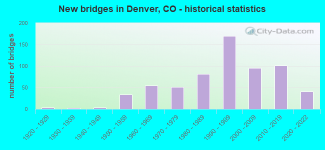
- New bridges - historical statistics
- 11910-1919
- 41920-1929
- 21930-1939
- 31940-1949
- 341950-1959
- 551960-1969
- 511970-1979
- 811980-1989
- 1701990-1999
- 952000-2009
- 1012010-2019
- 412020-2022
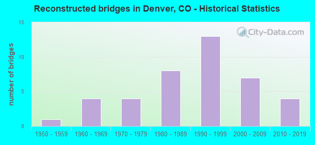
- Reconstructed bridges - Historical Statistics
- 11950-1959
- 41960-1969
- 41970-1979
- 81980-1989
- 131990-1999
- 72000-2009
- 42010-2019
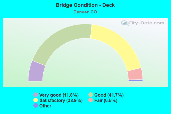
- Bridge Condition - Deck
- 11.8%Very good
- 41.7%Good
- 38.9%Satisfactory
- 6.5%Fair
- 1.0%Poor
- 0.3%Serious
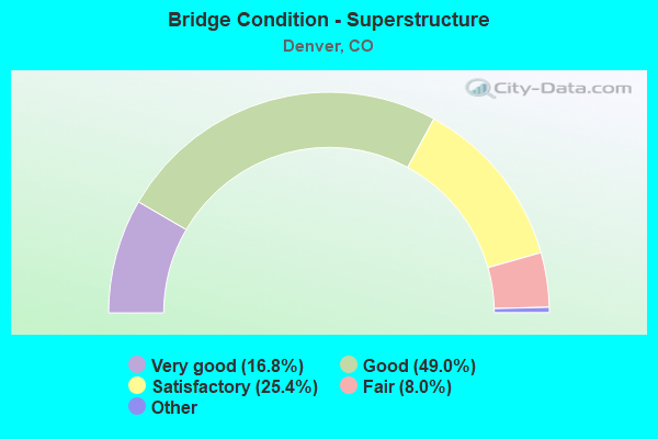
- Bridge Condition - Superstructure
- 16.8%Very good
- 49.0%Good
- 25.4%Satisfactory
- 8.0%Fair
- 0.8%Poor
- 0.3%Serious
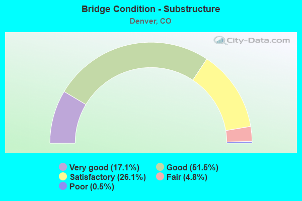
- Bridge Condition - Substructure
- 17.1%Very good
- 51.5%Good
- 26.1%Satisfactory
- 4.8%Fair
- 0.5%Poor
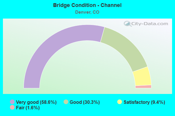
- Bridge Condition - Channel
- 58.6%Very good
- 30.3%Good
- 9.4%Satisfactory
- 1.6%Fair
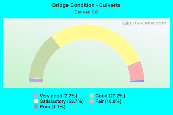
- Bridge Condition - Culverts
- 2.2%Very good
- 27.2%Good
- 58.7%Satisfactory
- 10.9%Fair
- 1.1%Poor
Find on map >> Show street view
Structure Number: D-31-PB-22, Location: 2.75 MI NORTH OF I-70 (Lat: 39.803725, Lng: -104.787203), Route carried "on" structure: City street , Year Built: 1993, Status: Open, Structure Length: 4.39m (14.40ft), Average Daily Traffic: 49,885 (year 2021), Truck Traffic: 6%, Average Future Daily Traffic: 55,372 (year 2041), Design Load: HS 20, Features Intersected: FIRST CREEK, Facility Carried by Structure: SB PENA BLVD
Minimum Vertical Clearance: 30.45m (99.90ft), Kilometerpoint: 5.571, Lanes on structure: 2, Base Highway Network: Yes, Owner: Local Agency, Approaching Roadway Width: 12.2m (40.0ft), Skew: 1 degrees, Material/Design: Prestressed concrete, Design/Construction: Box Beam or Girders - Multiple, Number Of Spans In Main Unit: 1, Length of Maximum Span: 41.5m (136.2ft), Curb-To-Curb Width: 12.3m (40.4ft), Out-to-Out Width: 13.0m (42.7ft)
Condition: Deck: Satisfactory, Superstructure: Good, Substructure: Satisfactory, Channel: Very good, Operating Rating: 73.2 metric tons, Method Used To Determine Operating Rating: Load Factor (LF), Inventory Rating: 43.9 metric tons, Method Used To Determine Inventory Rating: Load Factor (LF), Structural Evaluation: Equal to present minimum criteria, Deck Geometry: Better than present minimum criteria, Waterway Adequacy: Equal to present desirable criteria, Approach Roadway Alignment: Equal to present desirable criteria, Designated Inspection Frequency: Every 24 months, Inspection Date: December 2020, Deck Structure Type: Concrete Cast-file-Place, Wearing Surface/Protective System: Wearing Surface: Monolithic Concrete, Deck Protection: Epoxy Coated Reinforcing
Find on map >> Show street view
Structure Number: D-31-PB-23, Location: 2.75 MI NORTH OF I-70 (Lat: 39.803622, Lng: -104.786317), Route carried "on" structure: City street , Year Built: 1993, Status: Open, Structure Length: 4.40m (14.44ft), Average Daily Traffic: 49,885 (year 2021), Truck Traffic: 6%, Average Future Daily Traffic: 55,372 (year 2041), Design Load: HS 20, Features Intersected: FIRST CREEK, Facility Carried by Structure: NB PENA BLVD
Minimum Vertical Clearance: 30.45m (99.90ft), Kilometerpoint: 5.560, Lanes on structure: 2, Base Highway Network: Yes, Owner: Local Agency, Approaching Roadway Width: 12.2m (40.0ft), Skew: 1 degrees, Material/Design: Prestressed concrete, Design/Construction: Box Beam or Girders - Multiple, Number Of Spans In Main Unit: 1, Length of Maximum Span: 41.5m (136.2ft), Curb-To-Curb Width: 12.3m (40.4ft), Out-to-Out Width: 13.0m (42.7ft)
Condition: Deck: Satisfactory, Superstructure: Good, Substructure: Satisfactory, Channel: Very good, Operating Rating: 68.9 metric tons, Method Used To Determine Operating Rating: Load Factor (LF), Inventory Rating: 41.4 metric tons, Method Used To Determine Inventory Rating: Load Factor (LF), Structural Evaluation: Equal to present minimum criteria, Deck Geometry: Better than present minimum criteria, Waterway Adequacy: Equal to present desirable criteria, Approach Roadway Alignment: Equal to present desirable criteria, Designated Inspection Frequency: Every 24 months, Inspection Date: December 2020, Deck Structure Type: Concrete Cast-file-Place, Wearing Surface/Protective System: Wearing Surface: Monolithic Concrete, Deck Protection: Epoxy Coated Reinforcing
Find on map >> Show street view
Structure Number: D-31-PB-31, Location: WEST OF TOWER ROAD (Lat: 39.832628, Lng: -104.776508), Route carried "on" structure: City street , Year Built: 1993, Year Reconstructed: 2018, Status: Open, Structure Length: 4.44m (14.57ft), Average Daily Traffic: 50,608 (year 2021), Truck Traffic: 6%, Average Future Daily Traffic: 56,175 (year 2041), Design Load: HS 20, Features Intersected: SECOND CREEK TRIB, Facility Carried by Structure: SB PENA BLVD
Minimum Vertical Clearance: 30.45m (99.90ft), Kilometerpoint: 9.032, Lanes on structure: 3, Base Highway Network: Yes, Owner: Local Agency, Approaching Roadway Width: 22.2m (72.8ft), Material/Design: Prestressed concrete, Design/Construction: Box Beam or Girders - Multiple, Number Of Spans In Main Unit: 1, Length of Maximum Span: 43.6m (143.0ft), Curb-To-Curb Width: 22.0m (72.2ft), Out-to-Out Width: 23.0m (75.5ft)
Condition: Deck: Satisfactory, Superstructure: Good, Substructure: Good, Channel: Good, Operating Rating: 67.7 metric tons, Method Used To Determine Operating Rating: Load and Resistance Factor Rating (LRFR) rating reported by rating factor(RF) method using HL-93 loadings, Inventory Rating: 35.6 metric tons, Method Used To Determine Inventory Rating: Load and Resistance Factor Rating (LRFR) rating reported by rating factor(RF) method using HL-93 loadings, Structural Evaluation: Better than present minimum criteria, Deck Geometry: Superior to present desirable criteria, Waterway Adequacy: Equal to present desirable criteria, Approach Roadway Alignment: Equal to present desirable criteria, Designated Inspection Frequency: Every 24 months, Inspection Date: December 2020, Deck Structure Type: Concrete Cast-file-Place, Wearing Surface/Protective System: Wearing Surface: Monolithic Concrete, Deck Protection: Epoxy Coated Reinforcing
Find on map >> Show street view
Structure Number: D-31-PB-32, Location: WEST OF TOWER ROAD (Lat: 39.832042, Lng: -104.776031), Route carried "on" structure: City street , Year Built: 1993, Status: Open, Structure Length: 4.52m (14.83ft), Average Daily Traffic: 50,608 (year 2021), Truck Traffic: 6%, Average Future Daily Traffic: 56,175 (year 2041), Design Load: HS 20, Features Intersected: SECOND CREEK TRIB, Facility Carried by Structure: NB PENA BLVD
Minimum Vertical Clearance: 30+ m (98+ ft), Kilometerpoint: 9.035, Lanes on structure: 2, Base Highway Network: Yes, Owner: Local Agency, Approaching Roadway Width: 12.2m (40.0ft), Material/Design: Prestressed concrete, Design/Construction: Box Beam or Girders - Multiple, Number Of Spans In Main Unit: 1, Length of Maximum Span: 43.6m (143.0ft), Curb-To-Curb Width: 12.2m (40.0ft), Out-to-Out Width: 13.0m (42.7ft)
Condition: Deck: Satisfactory, Superstructure: Good, Substructure: Good, Channel: Good, Operating Rating: 75.8 metric tons, Method Used To Determine Operating Rating: Load Factor (LF), Inventory Rating: 45.4 metric tons, Method Used To Determine Inventory Rating: Load Factor (LF), Structural Evaluation: Better than present minimum criteria, Deck Geometry: Better than present minimum criteria, Waterway Adequacy: Equal to present desirable criteria, Approach Roadway Alignment: Equal to present desirable criteria, Designated Inspection Frequency: Every 24 months, Inspection Date: December 2020, Deck Structure Type: Concrete Cast-file-Place, Wearing Surface/Protective System: Wearing Surface: Monolithic Concrete, Deck Protection: Epoxy Coated Reinforcing
Find on map >> Show street view
Structure Number: D-31-PB-35, Location: 5.0 MI NORTH OF I-70 (Lat: 39.834006, Lng: -104.772208), Route carried "on" structure: City street , Year Built: 1992, Status: Open, Structure Length: 7.56m (24.80ft), Average Daily Traffic: 50,608 (year 2021), Truck Traffic: 6%, Average Future Daily Traffic: 56,175 (year 2041), Design Load: HS 20, Features Intersected: TOWER ROAD, Facility Carried by Structure: SB PENA BLVD
Minimum Vertical Clearance: 5.54m (18.18ft), Kilometerpoint: 0.952, Lanes on structure: 2, Lanes under structure: 5, Base Highway Network: Yes, Owner: Local Agency, Approaching Roadway Width: 12.2m (40.0ft), Skew: 1 degrees, Material/Design: Prestressed concrete continuous, Design/Construction: Box Beam or Girders - Multiple, Number Of Spans In Main Unit: 2, Length of Maximum Span: 37.6m (123.4ft), Curb-To-Curb Width: 12.2m (40.0ft), Out-to-Out Width: 13.0m (42.7ft)
Condition: Deck: Satisfactory, Superstructure: Good, Substructure: Good, Operating Rating: 72.1 metric tons, Method Used To Determine Operating Rating: Load Factor (LF), Inventory Rating: 43.2 metric tons, Method Used To Determine Inventory Rating: Load Factor (LF), Structural Evaluation: Better than present minimum criteria, Deck Geometry: Better than present minimum criteria, Underclear: Superior to present desirable criteria, Approach Roadway Alignment: Equal to present desirable criteria, Designated Inspection Frequency: Every 24 months, Inspection Date: December 2020, Deck Structure Type: Concrete Cast-file-Place, Wearing Surface/Protective System: Wearing Surface: Monolithic Concrete, Deck Protection: Epoxy Coated Reinforcing
Find on map >> Show street view
Structure Number: D-31-PB-36, Location: 5.0 MI NORTH OF I-70 (Lat: 39.833283, Lng: -104.772211), Route carried "on" structure: City street , Year Built: 1992, Status: Open, Structure Length: 7.56m (24.80ft), Average Daily Traffic: 50,608 (year 2021), Truck Traffic: 6%, Average Future Daily Traffic: 56,175 (year 2041), Design Load: HS 20, Features Intersected: TOWER ROAD, Facility Carried by Structure: NB PENA BLVD
Minimum Vertical Clearance: 5.54m (18.18ft), Kilometerpoint: 9.392, Lanes on structure: 2, Lanes under structure: 5, Base Highway Network: Yes, Owner: Local Agency, Approaching Roadway Width: 12.2m (40.0ft), Skew: 1 degrees, Material/Design: Prestressed concrete continuous, Design/Construction: Box Beam or Girders - Multiple, Number Of Spans In Main Unit: 2, Length of Maximum Span: 38.1m (125.0ft), Curb-To-Curb Width: 12.2m (40.0ft), Out-to-Out Width: 13.0m (42.7ft)
Condition: Deck: Satisfactory, Superstructure: Good, Substructure: Good, Operating Rating: 72.1 metric tons, Method Used To Determine Operating Rating: Load Factor (LF), Inventory Rating: 43.2 metric tons, Method Used To Determine Inventory Rating: Load Factor (LF), Structural Evaluation: Better than present minimum criteria, Deck Geometry: Better than present minimum criteria, Underclear: Superior to present desirable criteria, Approach Roadway Alignment: Equal to present desirable criteria, Designated Inspection Frequency: Every 24 months, Inspection Date: December 2020, Deck Structure Type: Concrete Cast-file-Place, Wearing Surface/Protective System: Wearing Surface: Monolithic Concrete, Deck Protection: Epoxy Coated Reinforcing
Find on map >> Show street view
Structure Number: D-31-PB-41, Location: 0.4 MI EAST OF E-470 (Lat: 39.834433, Lng: -104.735408), Route carried "on" structure: City street , Year Built: 1992, Status: Open, Structure Length: 5.72m (18.77ft), Average Daily Traffic: 69,239 (year 2021), Truck Traffic: 6%, Average Future Daily Traffic: 76,855 (year 2041), Design Load: HS 20, Features Intersected: FUTURE PICADILLY RD, Facility Carried by Structure: SB PENA BLVD
Minimum Vertical Clearance: 30.45m (99.90ft), Kilometerpoint: 2.499, Lanes on structure: 4, Owner: Local Agency, Approaching Roadway Width: 18.9m (62.0ft), Skew: 1 degrees, Material/Design: Prestressed concrete, Design/Construction: Box Beam or Girders - Multiple, Number Of Spans In Main Unit: 1, Length of Maximum Span: 55.6m (182.4ft), Curb-To-Curb Width: 19.4m (63.6ft), Out-to-Out Width: 20.1m (65.9ft)
Condition: Deck: Satisfactory, Superstructure: Good, Substructure: Good, Inventory Rating: 61.6 metric tons, Method Used To Determine Inventory Rating: Load Factor (LF), Structural Evaluation: Better than present minimum criteria, Deck Geometry: Somewhat better than minimum adequacy, Approach Roadway Alignment: Equal to present desirable criteria, Designated Inspection Frequency: Every 24 months, Inspection Date: December 2020, Deck Structure Type: Concrete Cast-file-Place, Wearing Surface/Protective System: Wearing Surface: Monolithic Concrete, Deck Protection: Epoxy Coated Reinforcing
Find on map >> Show street view
Structure Number: D-31-PB-42, Location: 0.4 MI EAST OF E-470 (Lat: 39.833756, Lng: -104.734764), Route carried "on" structure: City street , Year Built: 1992, Status: Open, Structure Length: 5.72m (18.77ft), Average Daily Traffic: 69,239 (year 2021), Truck Traffic: 6%, Average Future Daily Traffic: 76,855 (year 2041), Design Load: HS 20, Features Intersected: FUTURE PICADILLY RD, Facility Carried by Structure: NB PENA BLVD
Minimum Vertical Clearance: 30.45m (99.90ft), Kilometerpoint: 2.522, Lanes on structure: 4, Owner: Local Agency, Approaching Roadway Width: 21.3m (69.9ft), Skew: 1 degrees, Material/Design: Prestressed concrete, Design/Construction: Box Beam or Girders - Multiple, Number Of Spans In Main Unit: 1, Length of Maximum Span: 55.6m (182.4ft), Curb-To-Curb Width: 22.1m (72.5ft), Out-to-Out Width: 22.9m (75.1ft)
Condition: Deck: Satisfactory, Superstructure: Good, Substructure: Satisfactory, Inventory Rating: 58.4 metric tons, Method Used To Determine Inventory Rating: Load Factor (LF), Structural Evaluation: Equal to present minimum criteria, Deck Geometry: Equal to present desirable criteria, Approach Roadway Alignment: Equal to present desirable criteria, Designated Inspection Frequency: Every 24 months, Inspection Date: December 2020, Deck Structure Type: Concrete Cast-file-Place, Wearing Surface/Protective System: Wearing Surface: Monolithic Concrete, Deck Protection: Epoxy Coated Reinforcing
Find on map >> Show street view
Structure Number: D-31-PB-44, Location: 0.2 MI W OF 75TH AVE (Lat: 39.833267, Lng: -104.730058), Route carried "on" structure: City street , Year Built: 1992, Status: Open, Structure Length: 1.13m (3.71ft), Average Daily Traffic: 69,239 (year 2021), Truck Traffic: 6%, Average Future Daily Traffic: 76,855 (year 2041), Design Load: HS 20, Features Intersected: SECOND CREEK, Facility Carried by Structure: PENA BLVD
Minimum Vertical Clearance: 30.45m (99.90ft), Kilometerpoint: 2.932, Lanes on structure: 8, Owner: Local Agency, Approaching Roadway Width: 65.8m (215.9ft), Skew: 23 degrees, Material/Design: Concrete, Design/Construction: Culvert, Number Of Spans In Main Unit: 3, Length of Maximum Span: 4.2m (13.8ft), Curb-To-Curb Width: 65.8m (215.9ft), Out-to-Out Width: 153.4m (503.3ft)
Condition: Channel: Good, Culverts: Satisfactory, Structural Evaluation: Equal to present minimum criteria, Deck Geometry: Superior to present desirable criteria, Waterway Adequacy: Equal to present desirable criteria, Approach Roadway Alignment: Equal to present desirable criteria, Designated Inspection Frequency: Every 24 months, Inspection Date: December 2020
Find on map >> Show street view
Structure Number: D-31-PB-46, Location: 2.0 MI EAST OF E-470 (Lat: 39.834325, Lng: -104.715703), Route carried "on" structure: City street , Year Built: 1992, Status: Open, Structure Length: 5.71m (18.73ft), Average Daily Traffic: 53,666 (year 2021), Truck Traffic: 6%, Average Future Daily Traffic: 59,569 (year 2041), Design Load: HS 20, Features Intersected: GUN CLUB ROAD, Facility Carried by Structure: SB PENA BLVD
Minimum Vertical Clearance: 30+ m (98+ ft), Kilometerpoint: 0.380, Lanes on structure: 3, Lanes under structure: 3, Owner: Local Agency, Approaching Roadway Width: 15.8m (51.8ft), Material/Design: Prestressed concrete, Design/Construction: Box Beam or Girders - Multiple, Number Of Spans In Main Unit: 1, Length of Maximum Span: 55.6m (182.4ft), Curb-To-Curb Width: 15.9m (52.2ft), Out-to-Out Width: 16.6m (54.5ft)
Condition: Deck: Satisfactory, Superstructure: Good, Substructure: Good, Operating Rating: 87.2 metric tons, Method Used To Determine Operating Rating: Load Factor (LF), Inventory Rating: 38.6 metric tons, Method Used To Determine Inventory Rating: Load Factor (LF), Structural Evaluation: Better than present minimum criteria, Deck Geometry: Somewhat better than minimum adequacy, Underclear: Better than present minimum criteria, Approach Roadway Alignment: Equal to present desirable criteria, Designated Inspection Frequency: Every 24 months, Inspection Date: December 2020, Deck Structure Type: Concrete Cast-file-Place, Wearing Surface/Protective System: Wearing Surface: Monolithic Concrete, Deck Protection: Epoxy Coated Reinforcing
Find on map >> Show street view
Structure Number: D-31-PB-47, Location: 2.0 MI EAST OF E-470 (Lat: 39.833561, Lng: -104.715717), Route carried "on" structure: City street , Year Built: 1992, Status: Open, Structure Length: 5.72m (18.77ft), Average Daily Traffic: 53,666 (year 2021), Truck Traffic: 6%, Average Future Daily Traffic: 59,569 (year 2041), Design Load: HS 20, Features Intersected: GUN CLUB ROAD, Facility Carried by Structure: NB PENA BLVD
Minimum Vertical Clearance: 30+ m (98+ ft), Kilometerpoint: 4.152, Lanes on structure: 3, Lanes under structure: 3, Owner: Local Agency, Approaching Roadway Width: 15.2m (49.9ft), Material/Design: Prestressed concrete, Design/Construction: Box Beam or Girders - Multiple, Number Of Spans In Main Unit: 1, Length of Maximum Span: 55.7m (182.7ft), Curb-To-Curb Width: 15.9m (52.2ft), Out-to-Out Width: 16.6m (54.5ft)
Condition: Deck: Satisfactory, Superstructure: Good, Substructure: Good, Operating Rating: 87.2 metric tons, Method Used To Determine Operating Rating: Load Factor (LF), Inventory Rating: 38.6 metric tons, Method Used To Determine Inventory Rating: Load Factor (LF), Structural Evaluation: Better than present minimum criteria, Deck Geometry: Somewhat better than minimum adequacy, Underclear: Better than present minimum criteria, Approach Roadway Alignment: Equal to present desirable criteria, Designated Inspection Frequency: Every 24 months, Inspection Date: December 2020, Deck Structure Type: Concrete Cast-file-Place, Wearing Surface/Protective System: Wearing Surface: Monolithic Concrete, Deck Protection: Epoxy Coated Reinforcing
Find on map >> Show street view
Structure Number: D-31-PB-51, Location: JUST W OF JACKSON GAP RD (Lat: 39.837756, Lng: -104.693811), Route carried "on" structure: City street , Year Built: 1992, Status: Open, Structure Length: 0.73m (2.40ft), Average Daily Traffic: 18,020 (year 2021), Truck Traffic: 6%, Average Future Daily Traffic: 20,002 (year 2041), Design Load: HS 20, Features Intersected: THIRD CREEK TRIB, Facility Carried by Structure: 78TH AVE
Minimum Vertical Clearance: 30.45m (99.90ft), Kilometerpoint: 3.528, Lanes on structure: 5, Owner: Local Agency, Approaching Roadway Width: 18.6m (61.0ft), Skew: 33 degrees, Material/Design: Concrete, Design/Construction: Culvert, Number Of Spans In Main Unit: 2, Length of Maximum Span: 3.5m (11.5ft), Curb-To-Curb Width: 18.6m (61.0ft), Out-to-Out Width: 36.8m (120.7ft)
Condition: Channel: Good, Culverts: Satisfactory, Structural Evaluation: Equal to present minimum criteria, Deck Geometry: High priority of corrective action, Waterway Adequacy: Better than present minimum criteria, Approach Roadway Alignment: Equal to present desirable criteria, Designated Inspection Frequency: Every 24 months, Inspection Date: December 2020
Find on map >> Show street view
Structure Number: D-31-PB-53, Location: 3.0 MI EAST OF E-470 (Lat: 39.834172, Lng: -104.693103), Route carried "on" structure: City street , Year Built: 1992, Status: Open, Structure Length: 5.71m (18.73ft), Average Daily Traffic: 52,330 (year 2021), Truck Traffic: 6%, Average Future Daily Traffic: 58,086 (year 2041), Design Load: HS 20, Features Intersected: JACKSON GAP ST, Facility Carried by Structure: SB PENA BLVD
Minimum Vertical Clearance: 30+ m (98+ ft), Kilometerpoint: 1.152, Lanes on structure: 3, Lanes under structure: 5, Owner: Local Agency, Approaching Roadway Width: 15.8m (51.8ft), Skew: 10 degrees, Material/Design: Prestressed concrete, Design/Construction: Box Beam or Girders - Multiple, Number Of Spans In Main Unit: 1, Length of Maximum Span: 55.6m (182.4ft), Curb-To-Curb Width: 15.8m (51.8ft), Out-to-Out Width: 16.7m (54.8ft)
Condition: Deck: Satisfactory, Superstructure: Very good, Substructure: Good, Operating Rating: 87.2 metric tons, Method Used To Determine Operating Rating: Load Factor (LF), Inventory Rating: 38.6 metric tons, Method Used To Determine Inventory Rating: Load Factor (LF), Structural Evaluation: Better than present minimum criteria, Deck Geometry: Somewhat better than minimum adequacy, Underclear: Superior to present desirable criteria, Approach Roadway Alignment: Equal to present desirable criteria, Designated Inspection Frequency: Every 24 months, Inspection Date: December 2020, Deck Structure Type: Concrete Cast-file-Place, Wearing Surface/Protective System: Wearing Surface: Monolithic Concrete, Deck Protection: Epoxy Coated Reinforcing
Find on map >> Show street view
Structure Number: D-31-PB-54, Location: 3.0 MI EAST OF E-470 (Lat: 39.833386, Lng: -104.693117), Route carried "on" structure: City street , Year Built: 1992, Status: Open, Structure Length: 5.72m (18.77ft), Average Daily Traffic: 52,330 (year 2021), Truck Traffic: 6%, Average Future Daily Traffic: 58,086 (year 2041), Design Load: HS 20, Features Intersected: JACKSON GAP RD, Facility Carried by Structure: NB PENA BLVD
Minimum Vertical Clearance: 30+ m (98+ ft), Kilometerpoint: 6.085, Lanes on structure: 3, Lanes under structure: 5, Owner: Local Agency, Approaching Roadway Width: 15.8m (51.8ft), Material/Design: Prestressed concrete, Design/Construction: Box Beam or Girders - Multiple, Number Of Spans In Main Unit: 1, Length of Maximum Span: 55.6m (182.4ft), Curb-To-Curb Width: 15.8m (51.8ft), Out-to-Out Width: 16.6m (54.5ft)
Condition: Deck: Satisfactory, Superstructure: Satisfactory, Substructure: Good, Operating Rating: 87.2 metric tons, Method Used To Determine Operating Rating: Load Factor (LF), Inventory Rating: 38.6 metric tons, Method Used To Determine Inventory Rating: Load Factor (LF), Structural Evaluation: Equal to present minimum criteria, Deck Geometry: Somewhat better than minimum adequacy, Underclear: Better than present minimum criteria, Approach Roadway Alignment: Equal to present desirable criteria, Designated Inspection Frequency: Every 24 months, Inspection Date: December 2020, Deck Structure Type: Concrete Cast-file-Place, Wearing Surface/Protective System: Wearing Surface: Monolithic Concrete, Deck Protection: Epoxy Coated Reinforcing
Find on map >> Show street view
Structure Number: D-31-PB-62, Location: 3.5 MI EAST OF E-470 (Lat: 39.833936, Lng: -104.681361), Route carried "on" structure: City street , Year Built: 1992, Status: Open, Structure Length: 0.64m (2.10ft), Average Daily Traffic: 55,210 (year 2021), Truck Traffic: 6%, Average Future Daily Traffic: 61,283 (year 2041), Design Load: HS 20, Features Intersected: THIRD CREEK, Facility Carried by Structure: SB PENA BLVD
Minimum Vertical Clearance: 30.45m (99.90ft), Kilometerpoint: 7.088, Lanes on structure: 3, Owner: Local Agency, Approaching Roadway Width: 16.0m (52.5ft), Material/Design: Concrete, Design/Construction: Culvert, Number Of Spans In Main Unit: 2, Length of Maximum Span: 3.0m (9.8ft), Out-to-Out Width: 38.0m (124.7ft)
Condition: Channel: Good, Culverts: Good, Inventory Rating: 74.3 metric tons, Method Used To Determine Inventory Rating: Load Factor (LF), Structural Evaluation: Better than present minimum criteria, Waterway Adequacy: Equal to present desirable criteria, Approach Roadway Alignment: Equal to present desirable criteria, Designated Inspection Frequency: Every 24 months, Inspection Date: December 2020
Find on map >> Show street view
Structure Number: D-31-PB-63, Location: 3.5 MI EAST OF E-470 (Lat: 39.833269, Lng: -104.681306), Route carried "on" structure: City street , Year Built: 1992, Status: Open, Structure Length: 0.64m (2.10ft), Average Daily Traffic: 55,210 (year 2021), Truck Traffic: 6%, Average Future Daily Traffic: 61,283 (year 2041), Design Load: HS 20, Features Intersected: THIRD CREEK, Facility Carried by Structure: NB PENA BLVD
Minimum Vertical Clearance: 30.45m (99.90ft), Kilometerpoint: 7.091, Lanes on structure: 3, Owner: Local Agency, Approaching Roadway Width: 17.1m (56.1ft), Material/Design: Concrete, Design/Construction: Culvert, Number Of Spans In Main Unit: 2, Length of Maximum Span: 3.0m (9.8ft), Out-to-Out Width: 53.1m (174.2ft)
Condition: Channel: Good, Culverts: Satisfactory, Operating Rating: 49.7 metric tons, Method Used To Determine Operating Rating: Load Factor (LF), Inventory Rating: 29.8 metric tons, Method Used To Determine Inventory Rating: Load Factor (LF), Structural Evaluation: Equal to present minimum criteria, Waterway Adequacy: Equal to present desirable criteria, Approach Roadway Alignment: Equal to present desirable criteria, Designated Inspection Frequency: Every 24 months, Inspection Date: December 2020
Find on map >> Show street view
Structure Number: D-31-PB-65, Location: 4.2 MI EAST OF E-470 (Lat: 39.834406, Lng: -104.672828), Route carried "on" structure: City street , Year Built: 1992, Status: Open, Structure Length: 5.50m (18.04ft), Average Daily Traffic: 55,210 (year 2021), Truck Traffic: 6%, Average Future Daily Traffic: 61,283 (year 2041), Design Load: HS 20, Features Intersected: NB PENA BLVD, Facility Carried by Structure: 76TH AVENUE
Minimum Vertical Clearance: 5.84m (19.16ft), Kilometerpoint: 7.844, Lanes on structure: 2, Lanes under structure: 4, Owner: Local Agency, Approaching Roadway Width: 11.0m (36.1ft), Skew: 3 degrees, Material/Design: Prestressed concrete, Design/Construction: Box Beam or Girders - Multiple, Number Of Spans In Main Unit: 1, Length of Maximum Span: 51.7m (169.6ft), Curb-To-Curb Width: 11.0m (36.1ft), Out-to-Out Width: 11.8m (38.7ft)
Condition: Deck: Satisfactory, Superstructure: Good, Substructure: Satisfactory, Operating Rating: 70.8 metric tons, Method Used To Determine Operating Rating: Load Factor (LF), Inventory Rating: 42.5 metric tons, Method Used To Determine Inventory Rating: Load Factor (LF), Structural Evaluation: Equal to present minimum criteria, Deck Geometry: Somewhat better than minimum adequacy, Underclear: Equal to present minimum criteria, Approach Roadway Alignment: Equal to present desirable criteria, Designated Inspection Frequency: Every 24 months, Inspection Date: December 2020, Deck Structure Type: Concrete Cast-file-Place, Wearing Surface/Protective System: Wearing Surface: Monolithic Concrete, Deck Protection: Epoxy Coated Reinforcing
Find on map >> Show street view
Structure Number: D-31-PB-66, Location: S OF TERMINAL BLDG (Lat: 39.842142, Lng: -104.673889), Route carried "on" structure: City street , Year Built: 2017, Status: Open, Structure Length: 1.13m (3.71ft), Average Daily Traffic: 24,833 (year 2021), Truck Traffic: 6%, Average Future Daily Traffic: 27,564 (year 2041), Design Load: HL 93, Features Intersected: RTD COMMUTER RAIL, Facility Carried by Structure: SCOTTSBURG ROAD
Minimum Vertical Clearance: 5.87m (19.26ft), Kilometerpoint: 0.351, Lanes on structure: 5, Owner: Local Agency, Approaching Roadway Width: 53.9m (176.8ft), Material/Design: Concrete, Design/Construction: Frame, Number Of Spans In Main Unit: 1, Length of Maximum Span: 10.1m (33.1ft), Curb-To-Curb Width: 53.9m (176.8ft), Out-to-Out Width: 54.9m (180.1ft)
Condition: Deck: Satisfactory, Superstructure: Satisfactory, Substructure: Satisfactory, Operating Rating: 54.4 metric tons, Method Used To Determine Operating Rating: Load and Resistance Factor Rating (LRFR) rating reported by rating factor(RF) method using HL-93 loadings, Inventory Rating: 42.1 metric tons, Method Used To Determine Inventory Rating: Load and Resistance Factor Rating (LRFR) rating reported by rating factor(RF) method using HL-93 loadings, Structural Evaluation: Equal to present minimum criteria, Deck Geometry: Superior to present desirable criteria, Underclear: Meets minimum limits, Approach Roadway Alignment: Equal to present desirable criteria, Designated Inspection Frequency: Every 24 months, Inspection Date: December 2020, Deck Structure Type: Concrete Cast-file-Place, Wearing Surface/Protective System: Wearing Surface: Monolithic Concrete, Membrane: Other
Find on map >> Show street view
Structure Number: D-31-PB-67, Location: S OF TERMINAL BLDG (Lat: 39.843142, Lng: -104.673944), Route carried "on" structure: City street , Year Built: 2017, Status: Open, Structure Length: 3.43m (11.25ft), Average Daily Traffic: 1,749 (year 2021), Average Future Daily Traffic: 1,942 (year 2041), Design Load: HL 93, Features Intersected: RTD COMMUTER LINE, Facility Carried by Structure: COMM. VEH. ROAD
Minimum Vertical Clearance: 30+ m (98+ ft), Kilometerpoint: 0.000, Lanes on structure: 1, Owner: Local Agency, Approaching Roadway Width: 7.5m (24.6ft), Skew: 1 degrees, Material/Design: Prestressed concrete, Design/Construction: Stringer/Multi-beam, Number Of Spans In Main Unit: 1, Length of Maximum Span: 32.7m (107.3ft), Curb-To-Curb Width: 7.3m (24.0ft), Out-to-Out Width: 11.7m (38.4ft)
Condition: Deck: Good, Superstructure: Very good, Substructure: Good, Operating Rating: 56.4 metric tons, Method Used To Determine Operating Rating: Load and Resistance Factor Rating (LRFR) rating reported by rating factor(RF) method using HL-93 loadings, Inventory Rating: 24.9 metric tons, Method Used To Determine Inventory Rating: Load and Resistance Factor Rating (LRFR) rating reported by rating factor(RF) method using HL-93 loadings, Structural Evaluation: Equal to present minimum criteria, Deck Geometry: Meets minimum limits, Underclear: Somewhat better than minimum adequacy, Approach Roadway Alignment: Equal to present minimum criteria, Designated Inspection Frequency: Every 24 months, Inspection Date: December 2020, Deck Structure Type: Concrete Precast Panels, Wearing Surface/Protective System: Wearing Surface: Monolithic Concrete, Deck Protection: Epoxy Coated Reinforcing
Find on map >> Show street view
Structure Number: D-31-PB-68, Location: S OF TERMINAL BLDG (Lat: 39.842114, Lng: -104.673992), Route carried "on" structure: City street , Year Built: 1992, Status: Open, Structure Length: 5.36m (17.59ft), Average Daily Traffic: 27,409 (year 2021), Truck Traffic: 6%, Average Future Daily Traffic: 30,424 (year 2041), Design Load: HS 20, Features Intersected: SCOTTSBURG ROAD, Facility Carried by Structure: QUEENSBURG ROAD
Minimum Vertical Clearance: 30.45m (99.90ft), Kilometerpoint: 0.346, Lanes on structure: 4, Lanes under structure: 5, Owner: Local Agency, Approaching Roadway Width: 19.5m (64.0ft), Material/Design: Prestressed concrete, Design/Construction: Box Beam or Girders - Single/Spread, Number Of Spans In Main Unit: 1, Length of Maximum Span: 50.6m (166.0ft), Curb-To-Curb Width: 19.5m (64.0ft), Out-to-Out Width: 20.3m (66.6ft)
Condition: Deck: Satisfactory, Superstructure: Good, Substructure: Satisfactory, Operating Rating: 71.3 metric tons, Method Used To Determine Operating Rating: Load Factor (LF), Inventory Rating: 42.7 metric tons, Method Used To Determine Inventory Rating: Load Factor (LF), Structural Evaluation: Equal to present minimum criteria, Deck Geometry: Better than present minimum criteria, Underclear: High priority of corrective action, Approach Roadway Alignment: Equal to present desirable criteria, Designated Inspection Frequency: Every 24 months, Inspection Date: December 2020, Deck Structure Type: Concrete Cast-file-Place, Wearing Surface/Protective System: Wearing Surface: Monolithic Concrete, Deck Protection: Epoxy Coated Reinforcing
Find on map >> Show street view
Structure Number: D-31-PB-69, Location: S OF TERMINAL BLDG (Lat: 39.841708, Lng: -104.673136), Route carried "on" structure: City street , Year Built: 1992, Status: Open, Structure Length: 0.64m (2.10ft), Average Daily Traffic: 24,833 (year 2021), Truck Traffic: 6%, Average Future Daily Traffic: 27,564 (year 2041), Design Load: HS 20, Features Intersected: THIRD CREEK TRIB, Facility Carried by Structure: SCOTTSBURG ROAD
Minimum Vertical Clearance: 30.45m (99.90ft), Kilometerpoint: 0.216, Lanes on structure: 4, Owner: Local Agency, Approaching Roadway Width: 23.2m (76.1ft), Material/Design: Concrete, Design/Construction: Culvert, Number Of Spans In Main Unit: 2, Length of Maximum Span: 3.0m (9.8ft), Out-to-Out Width: 53.2m (174.5ft)
Condition: Channel: Good, Culverts: Satisfactory, Operating Rating: 49.7 metric tons, Method Used To Determine Operating Rating: Load Factor (LF), Inventory Rating: 29.8 metric tons, Method Used To Determine Inventory Rating: Load Factor (LF), Structural Evaluation: Equal to present minimum criteria, Waterway Adequacy: Better than present minimum criteria, Approach Roadway Alignment: Equal to present desirable criteria, Designated Inspection Frequency: Every 24 months, Inspection Date: December 2020
Find on map >> Show street view
Structure Number: D-31-PB-7, Location: S OF TERMINAL BLDG (Lat: 39.842453, Lng: -104.674075), Route carried "on" structure: City street , Year Built: 2010, Status: Closed, Structure Length: 6.71m (22.01ft), Truck Traffic: 6%, Features Intersected: SCOTTSBURG ROAD, Facility Carried by Structure: HAUL ROAD
Minimum Vertical Clearance: 30.45m (99.90ft), Kilometerpoint: 0.327, Lanes on structure: 2, Lanes under structure: 5, Owner: Local Agency, Approaching Roadway Width: 13.1m (43.0ft), Material/Design: Prestressed concrete, Design/Construction: Stringer/Multi-beam, Number Of Spans In Main Unit: 1, Length of Maximum Span: 64.5m (211.6ft), Curb-To-Curb Width: 13.1m (43.0ft), Out-to-Out Width: 14.0m (45.9ft)
Condition: Deck: Good, Superstructure: Satisfactory, Substructure: Good, Operating Rating: 36.3 metric tons, Method Used To Determine Operating Rating: Field evaluation and documented engineering judgment, Inventory Rating: 32.7 metric tons, Method Used To Determine Inventory Rating: Field evaluation and documented engineering judgment, Structural Evaluation: Equal to present minimum criteria, Deck Geometry: Superior to present desirable criteria, Approach Roadway Alignment: Equal to present minimum criteria, Designated Inspection Frequency: Every 24 months, Inspection Date: December 2020, Deck Structure Type: Concrete Cast-file-Place, Wearing Surface/Protective System: Wearing Surface: Bituminous, Membrane: Preformed Fabric, Deck Protection: Epoxy Coated Reinforcing
Find on map >> Show street view
Structure Number: D-31-PB-71, Location: W TERMINAL OUTBOUND (Lat: 39.842969, Lng: -104.677253), Route carried "on" structure: City street , Year Built: 2010, Status: Open, Structure Length: 3.15m (10.33ft), Average Daily Traffic: 22,084 (year 2021), Truck Traffic: 6%, Average Future Daily Traffic: 24,513 (year 2041), Features Intersected: HAUL ROAD, Facility Carried by Structure: PENA BLVD
Minimum Vertical Clearance: 30.45m (99.90ft), Kilometerpoint: 0.407, Lanes on structure: 2, Lanes under structure: 2, Owner: Local Agency, Approaching Roadway Width: 12.2m (40.0ft), Skew: 2 degrees, Material/Design: Prestressed concrete, Design/Construction: Box Beam or Girders - Single/Spread, Number Of Spans In Main Unit: 1, Length of Maximum Span: 29.6m (97.1ft), Curb-To-Curb Width: 12.2m (40.0ft), Out-to-Out Width: 13.1m (43.0ft)
Condition: Deck: Satisfactory, Superstructure: Good, Substructure: Good, Operating Rating: 58.3 metric tons, Method Used To Determine Operating Rating: Load and Resistance Factor Rating (LRFR) rating reported by rating factor(RF) method using HL-93 loadings, Inventory Rating: 39.5 metric tons, Method Used To Determine Inventory Rating: Load and Resistance Factor Rating (LRFR) rating reported by rating factor(RF) method using HL-93 loadings, Structural Evaluation: Better than present minimum criteria, Deck Geometry: Better than present minimum criteria, Underclear: Superior to present desirable criteria, Approach Roadway Alignment: Equal to present desirable criteria, Designated Inspection Frequency: Every 24 months, Inspection Date: December 2020, Deck Structure Type: Concrete Cast-file-Place, Wearing Surface/Protective System: Wearing Surface: Monolithic Concrete, Deck Protection: Epoxy Coated Reinforcing
Find on map >> Show street view
Structure Number: D-31-PB-721A, Location: SE CORNER TERM BLDG (Lat: 39.847778, Lng: -104.673056), Route carried "on" structure: Ramp City street , Year Built: 2014, Status: Open, Structure Length: 13.37m (43.86ft), Average Daily Traffic: 11,241 (year 2021), Truck Traffic: 50%, Average Future Daily Traffic: 12,478 (year 2041), Design Load: HS 20, Features Intersected: 84TH AVENUE, Facility Carried by Structure: LEV 5 SE TERM RAMP
Minimum Vertical Clearance: 30.45m (99.90ft), Kilometerpoint: 0.647, Lanes on structure: 2, Lanes under structure: 3, Owner: Local Agency, Approaching Roadway Width: 7.3m (24.0ft), Material/Design: Prestressed concrete continuous, Design/Construction: Stringer/Multi-beam, Number Of Spans In Main Unit: 4, Number Of Approach Spans: 1, Length of Maximum Span: 35.2m (115.5ft), Curb or Sidewalk Widths: Left: 3.4m (11.2ft), Right: 0.0m, Curb-To-Curb Width: 9.1m (29.9ft), Out-to-Out Width: 13.9m (45.6ft)
Condition: Deck: Good, Superstructure: Very good, Substructure: Good, Operating Rating: 45.1 metric tons, Method Used To Determine Operating Rating: Load and Resistance Factor (LRFR), Inventory Rating: 27.0 metric tons, Method Used To Determine Inventory Rating: Load and Resistance Factor (LRFR), Structural Evaluation: Equal to present minimum criteria, Deck Geometry: Meets minimum limits, Underclear: Better than present minimum criteria, Approach Roadway Alignment: Equal to present desirable criteria, Designated Inspection Frequency: Every 24 months, Inspection Date: December 2020, Deck Structure Type: Concrete Cast-file-Place, Wearing Surface/Protective System: Wearing Surface: Monolithic Concrete, Deck Protection: Epoxy Coated Reinforcing
Find on map >> Show street view
Structure Number: D-31-PB-722A, Location: SE CORNER TERM BLDG (Lat: 39.846961, Lng: -104.672628), Route carried "on" structure: Ramp City street , Year Built: 2014, Status: Open, Structure Length: 13.37m (43.86ft), Average Daily Traffic: 11,984 (year 2021), Truck Traffic: 5%, Average Future Daily Traffic: 13,302 (year 2041), Design Load: HS 20, Features Intersected: 84TH AVENUE, Facility Carried by Structure: LEV 6 SE TERM RAMP
Minimum Vertical Clearance: 30.45m (99.90ft), Kilometerpoint: 0.545, Lanes on structure: 2, Lanes under structure: 3, Owner: Local Agency, Approaching Roadway Width: 7.3m (24.0ft), Material/Design: Prestressed concrete continuous, Design/Construction: Stringer/Multi-beam, Number Of Spans In Main Unit: 4, Number Of Approach Spans: 1, Length of Maximum Span: 35.2m (115.5ft), Curb-To-Curb Width: 11.0m (36.1ft), Out-to-Out Width: 12.0m (39.4ft)
Condition: Deck: Good, Superstructure: Good, Substructure: Good, Operating Rating: 48.0 metric tons, Method Used To Determine Operating Rating: Load and Resistance Factor (LRFR), Inventory Rating: 28.8 metric tons, Method Used To Determine Inventory Rating: Load and Resistance Factor (LRFR), Structural Evaluation: Better than present minimum criteria, Deck Geometry: Better than present minimum criteria, Underclear: Better than present minimum criteria, Approach Roadway Alignment: Equal to present desirable criteria, Designated Inspection Frequency: Every 24 months, Inspection Date: December 2020, Deck Structure Type: Concrete Cast-file-Place, Wearing Surface/Protective System: Wearing Surface: Monolithic Concrete, Deck Protection: Epoxy Coated Reinforcing
Find on map >> Show street view
Structure Number: D-31-PB-723A, Location: SE CORNER TERM BLDG (Lat: 39.847778, Lng: -104.672500), Route carried "on" structure: Ramp City street , Year Built: 2014, Status: Open, Structure Length: 13.37m (43.86ft), Average Daily Traffic: 8,856 (year 2021), Truck Traffic: 5%, Average Future Daily Traffic: 9,830 (year 2041), Design Load: HS 20, Features Intersected: 84TH AVENUE, Facility Carried by Structure: LEV 4 SE TERM RAMP
Minimum Vertical Clearance: 30.45m (99.90ft), Kilometerpoint: 0.632, Lanes on structure: 2, Lanes under structure: 3, Owner: Local Agency, Approaching Roadway Width: 7.3m (24.0ft), Material/Design: Prestressed concrete continuous, Design/Construction: Stringer/Multi-beam, Number Of Spans In Main Unit: 4, Number Of Approach Spans: 1, Length of Maximum Span: 35.2m (115.5ft), Curb-To-Curb Width: 11.0m (36.1ft), Out-to-Out Width: 12.0m (39.4ft)
Condition: Deck: Good, Superstructure: Good, Substructure: Good, Operating Rating: 48.0 metric tons, Method Used To Determine Operating Rating: Load and Resistance Factor (LRFR), Inventory Rating: 28.8 metric tons, Method Used To Determine Inventory Rating: Load and Resistance Factor (LRFR), Structural Evaluation: Better than present minimum criteria, Deck Geometry: Better than present minimum criteria, Approach Roadway Alignment: Equal to present desirable criteria, Designated Inspection Frequency: Every 24 months, Inspection Date: December 2020, Deck Structure Type: Concrete Cast-file-Place, Wearing Surface/Protective System: Wearing Surface: Monolithic Concrete, Deck Protection: Epoxy Coated Reinforcing
Find on map >> Show street view
Structure Number: D-31-PB-731, Location: EAST PARKING STRUCTURE (Lat: 39.850106, Lng: -104.670119), Route carried "on" structure: City street , Year Built: 1993, Status: Open, Structure Length: 2.83m (9.28ft), Average Daily Traffic: 2,030 (year 2021), Average Future Daily Traffic: 2,253 (year 2041), Design Load: HS 20, Features Intersected: PARKING LOT, Facility Carried by Structure: NE 2ND LEVEL PARK
Minimum Vertical Clearance: 2.44m (8.01ft), Kilometerpoint: 0.000, Lanes on structure: 2, Owner: Local Agency, Approaching Roadway Width: 10.1m (33.1ft), Material/Design: Prestressed concrete, Design/Construction: Box Beam or Girders - Single/Spread, Number Of Spans In Main Unit: 1, Number Of Approach Spans: 2, Length of Maximum Span: 14.3m (46.9ft), Curb-To-Curb Width: 10.3m (33.8ft), Out-to-Out Width: 11.5m (37.7ft)
Condition: Deck: Satisfactory, Superstructure: Good, Substructure: Satisfactory, Operating Rating: 46.0 metric tons, Method Used To Determine Operating Rating: Load Factor (LF), Inventory Rating: 27.6 metric tons, Method Used To Determine Inventory Rating: Load Factor (LF), Structural Evaluation: Equal to present minimum criteria, Deck Geometry: High priority of corrective action, Approach Roadway Alignment: Equal to present desirable criteria, Designated Inspection Frequency: Every 24 months, Inspection Date: December 2020, Deck Structure Type: Concrete Cast-file-Place, Wearing Surface/Protective System: Wearing Surface: Monolithic Concrete, Deck Protection: Epoxy Coated Reinforcing
Find on map >> Show street view
Structure Number: D-31-PB-732, Location: EAST PARKING STRUCTURE (Lat: 39.849281, Lng: -104.670117), Route carried "on" structure: City street , Year Built: 1993, Status: Open, Structure Length: 2.83m (9.28ft), Average Daily Traffic: 3,093 (year 2021), Average Future Daily Traffic: 3,434 (year 2041), Design Load: HS 20, Features Intersected: PARKING LOT, Facility Carried by Structure: E 2ND LEVEL PARK
Minimum Vertical Clearance: 2.44m (8.01ft), Kilometerpoint: 0.000, Lanes on structure: 2, Owner: Local Agency, Approaching Roadway Width: 10.1m (33.1ft), Material/Design: Prestressed concrete, Design/Construction: Box Beam or Girders - Single/Spread, Number Of Spans In Main Unit: 1, Number Of Approach Spans: 2, Length of Maximum Span: 14.3m (46.9ft), Curb-To-Curb Width: 10.3m (33.8ft), Out-to-Out Width: 11.5m (37.7ft)
Condition: Deck: Satisfactory, Superstructure: Good, Substructure: Satisfactory, Operating Rating: 46.0 metric tons, Method Used To Determine Operating Rating: Load Factor (LF), Inventory Rating: 27.6 metric tons, Method Used To Determine Inventory Rating: Load Factor (LF), Structural Evaluation: Equal to present minimum criteria, Deck Geometry: High priority of corrective action, Approach Roadway Alignment: Equal to present desirable criteria, Designated Inspection Frequency: Every 24 months, Inspection Date: December 2020, Deck Structure Type: Concrete Cast-file-Place, Wearing Surface/Protective System: Wearing Surface: Monolithic Concrete, Deck Protection: Epoxy Coated Reinforcing
Find on map >> Show street view
Structure Number: D-31-PB-733, Location: EAST PARKING STRUCTURE (Lat: 39.848456, Lng: -104.670133), Route carried "on" structure: City street , Year Built: 1993, Status: Open, Structure Length: 2.83m (9.28ft), Average Daily Traffic: 1,749 (year 2021), Average Future Daily Traffic: 1,942 (year 2041), Design Load: HS 20, Features Intersected: PARKING LOT, Facility Carried by Structure: SE 2ND LEVEL PARK
Minimum Vertical Clearance: 2.44m (8.01ft), Kilometerpoint: 0.000, Lanes on structure: 2, Owner: Local Agency, Approaching Roadway Width: 10.1m (33.1ft), Material/Design: Prestressed concrete, Design/Construction: Box Beam or Girders - Single/Spread, Number Of Spans In Main Unit: 1, Number Of Approach Spans: 2, Length of Maximum Span: 14.3m (46.9ft), Curb-To-Curb Width: 10.3m (33.8ft), Out-to-Out Width: 11.5m (37.7ft)
Condition: Deck: Satisfactory, Superstructure: Good, Substructure: Satisfactory, Operating Rating: 46.0 metric tons, Method Used To Determine Operating Rating: Load Factor (LF), Inventory Rating: 27.6 metric tons, Method Used To Determine Inventory Rating: Load Factor (LF), Structural Evaluation: Equal to present minimum criteria, Deck Geometry: High priority of corrective action, Approach Roadway Alignment: Equal to present desirable criteria, Designated Inspection Frequency: Every 24 months, Inspection Date: December 2020, Deck Structure Type: Concrete Cast-file-Place, Wearing Surface/Protective System: Wearing Surface: Monolithic Concrete, Deck Protection: Epoxy Coated Reinforcing
Find on map >> Show street view
Structure Number: D-31-PB-75, Location: SE OF EAST PARKING STRUCT (Lat: 39.848117, Lng: -104.669828), Route carried "on" structure: City street , Year Built: 1993, Status: Open, Structure Length: 3.92m (12.86ft), Average Daily Traffic: 5,163 (year 2021), Truck Traffic: 5%, Average Future Daily Traffic: 5,731 (year 2041), Design Load: HS 20, Features Intersected: 84TH AVENUE, Facility Carried by Structure: SE 2ND LEVEL EXIT
Minimum Vertical Clearance: 30.45m (99.90ft), Kilometerpoint: 0.000, Lanes on structure: 2, Lanes under structure: 2, Owner: Local Agency, Approaching Roadway Width: 10.7m (35.1ft), Material/Design: Prestressed concrete, Design/Construction: Box Beam or Girders - Single/Spread, Number Of Spans In Main Unit: 1, Number Of Approach Spans: 2, Length of Maximum Span: 14.6m (47.9ft), Curb-To-Curb Width: 11.0m (36.1ft), Out-to-Out Width: 11.7m (38.4ft)
Condition: Deck: Satisfactory, Superstructure: Good, Substructure: Satisfactory, Operating Rating: 43.7 metric tons, Method Used To Determine Operating Rating: Load Factor (LF), Inventory Rating: 25.8 metric tons, Method Used To Determine Inventory Rating: Load Factor (LF), Structural Evaluation: Equal to present minimum criteria, Deck Geometry: Equal to present minimum criteria, Underclear: High priority of corrective action, Approach Roadway Alignment: Equal to present desirable criteria, Designated Inspection Frequency: Every 24 months, Inspection Date: December 2020, Deck Structure Type: Concrete Cast-file-Place, Wearing Surface/Protective System: Wearing Surface: Monolithic Concrete, Deck Protection: Epoxy Coated Reinforcing
Find on map >> Show street view
Structure Number: D-31-PB-781, Location: NE CORNER TERM BLDG (Lat: 39.850583, Lng: -104.672531), Route carried "on" structure: Ramp City street , Year Built: 1993, Status: Open, Structure Length: 1.87m (6.14ft), Average Daily Traffic: 9,793 (year 2021), Truck Traffic: 5%, Average Future Daily Traffic: 10,871 (year 2041), Design Load: HS 20, Features Intersected: TERRAIN, Facility Carried by Structure: LEV 4 NE TERM RAMP
Minimum Vertical Clearance: 30.45m (99.90ft), Kilometerpoint: 0.290, Lanes on structure: 2, Owner: Local Agency, Approaching Roadway Width: 10.1m (33.1ft), Material/Design: Prestressed concrete, Design/Construction: Box Beam or Girders - Single/Spread, Number Of Spans In Main Unit: 1, Length of Maximum Span: 18.2m (59.7ft), Curb-To-Curb Width: 10.1m (33.1ft), Out-to-Out Width: 11.3m (37.1ft)
Condition: Deck: Satisfactory, Superstructure: Good, Substructure: Good, Operating Rating: 64.2 metric tons, Method Used To Determine Operating Rating: Load Factor (LF), Inventory Rating: 38.6 metric tons, Method Used To Determine Inventory Rating: Load Factor (LF), Structural Evaluation: Better than present minimum criteria, Deck Geometry: Equal to present minimum criteria, Approach Roadway Alignment: Equal to present desirable criteria, Designated Inspection Frequency: Every 24 months, Inspection Date: December 2020, Deck Structure Type: Concrete Cast-file-Place, Wearing Surface/Protective System: Wearing Surface: Monolithic Concrete, Deck Protection: Epoxy Coated Reinforcing
Find on map >> Show street view
Structure Number: D-31-PB-782, Location: NE CORNER TERM BLDG (Lat: 39.850500, Lng: -104.672781), Route carried "on" structure: Ramp City street , Year Built: 1993, Status: Open, Structure Length: 15.14m (49.67ft), Average Daily Traffic: 11,889 (year 2021), Truck Traffic: 5%, Average Future Daily Traffic: 13,197 (year 2041), Design Load: HS 20, Features Intersected: TERRAIN, Facility Carried by Structure: LEV 6 NE TERM RAMP
Minimum Vertical Clearance: 30.45m (99.90ft), Kilometerpoint: 0.301, Lanes on structure: 2, Owner: Local Agency, Approaching Roadway Width: 10.7m (35.1ft), Material/Design: Prestressed concrete continuous, Design/Construction: Box Beam or Girders - Single/Spread, Number Of Spans In Main Unit: 8, Length of Maximum Span: 19.3m (63.3ft), Curb-To-Curb Width: 10.9m (35.8ft), Out-to-Out Width: 12.1m (39.7ft)
Condition: Deck: Satisfactory, Superstructure: Satisfactory, Substructure: Good, Operating Rating: 65.0 metric tons, Method Used To Determine Operating Rating: Load Factor (LF), Inventory Rating: 38.6 metric tons, Method Used To Determine Inventory Rating: Load Factor (LF), Structural Evaluation: Equal to present minimum criteria, Deck Geometry: Better than present minimum criteria, Approach Roadway Alignment: Equal to present desirable criteria, Designated Inspection Frequency: Every 24 months, Inspection Date: December 2020, Deck Structure Type: Concrete Cast-file-Place, Wearing Surface/Protective System: Wearing Surface: Monolithic Concrete, Deck Protection: Epoxy Coated Reinforcing
Find on map >> Show street view
Structure Number: D-31-PB-783, Location: NE CORNER TERM BLDG (Lat: 39.850528, Lng: -104.672861), Route carried "on" structure: Ramp City street , Year Built: 1993, Status: Open, Structure Length: 3.70m (12.14ft), Average Daily Traffic: 8,065 (year 2021), Truck Traffic: 50%, Average Future Daily Traffic: 8,952 (year 2041), Design Load: HS 20, Features Intersected: TERRAIN, Facility Carried by Structure: LEV 5 NE TERM RAMP
Minimum Vertical Clearance: 30.45m (99.90ft), Kilometerpoint: 0.298, Lanes on structure: 2, Owner: Local Agency, Approaching Roadway Width: 10.6m (34.8ft), Material/Design: Prestressed concrete continuous, Design/Construction: Box Beam or Girders - Single/Spread, Number Of Spans In Main Unit: 2, Length of Maximum Span: 17.6m (57.7ft), Curb-To-Curb Width: 10.9m (35.8ft), Out-to-Out Width: 12.1m (39.7ft)
Condition: Deck: Satisfactory, Superstructure: Good, Substructure: Good, Operating Rating: 65.0 metric tons, Method Used To Determine Operating Rating: Load Factor (LF), Inventory Rating: 37.9 metric tons, Method Used To Determine Inventory Rating: Load Factor (LF), Structural Evaluation: Better than present minimum criteria, Deck Geometry: Better than present minimum criteria, Approach Roadway Alignment: Equal to present desirable criteria, Designated Inspection Frequency: Every 24 months, Inspection Date: December 2020, Deck Structure Type: Concrete Cast-file-Place, Wearing Surface/Protective System: Wearing Surface: Monolithic Concrete, Deck Protection: Epoxy Coated Reinforcing
Find on map >> Show street view
Structure Number: D-31-PB-801, Location: EAST OF NEW PARKING STR (Lat: 39.847478, Lng: -104.670197), Route carried "on" structure: City street , Year Built: 2017, Status: Open, Structure Length: 3.21m (10.53ft), Average Daily Traffic: 1,139 (year 2021), Average Future Daily Traffic: 1,265 (year 2041), Design Load: HS 20, Features Intersected: PARKING LOT, Facility Carried by Structure: SE 2ND LEVEL
Minimum Vertical Clearance: 30.18m (99.02ft), Kilometerpoint: 0.000, Lanes on structure: 2, Lanes under structure: 2, Owner: Local Agency, Approaching Roadway Width: 11.9m (39.0ft), Material/Design: Prestressed concrete, Design/Construction: Tee Beam, Number Of Spans In Main Unit: 3, Length of Maximum Span: 18.9m (62.0ft), Curb-To-Curb Width: 11.9m (39.0ft), Out-to-Out Width: 12.3m (40.4ft)
Condition: Deck: Good, Superstructure: Good, Substructure: Good, Operating Rating: 36.3 metric tons, Method Used To Determine Operating Rating: Field evaluation and documented engineering judgment, Inventory Rating: 32.7 metric tons, Method Used To Determine Inventory Rating: Field evaluation and documented engineering judgment, Structural Evaluation: Better than present minimum criteria, Deck Geometry: High priority of corrective action, Underclear: High priority of corrective action, Approach Roadway Alignment: Equal to present desirable criteria, Designated Inspection Frequency: Every 24 months, Inspection Date: December 2020, Deck Structure Type: Concrete Cast-file-Place
Find on map >> Show street view
Structure Number: D-31-PB-802, Location: BTWN SE GARAGES (Lat: 39.848039, Lng: -104.672014), Route carried "on" structure: City street , Year Built: 2017, Status: Open, Structure Length: 3.78m (12.40ft), Average Daily Traffic: 348 (year 2021), Average Future Daily Traffic: 386 (year 2041), Design Load: HS 20, Features Intersected: 84TH AVE., Facility Carried by Structure: SE 4/5TH LVL PARK
Minimum Vertical Clearance: 30+ m (98+ ft), Kilometerpoint: 0.000, Lanes on structure: 2, Lanes under structure: 2, Owner: Local Agency, Approaching Roadway Width: 12.1m (39.7ft), Skew: 30 degrees, Material/Design: Prestressed concrete, Design/Construction: Tee Beam, Number Of Spans In Main Unit: 3, Length of Maximum Span: 17.6m (57.7ft), Curb or Sidewalk Widths: Left: 0.0m, Right: 3.4m (11.2ft), Curb-To-Curb Width: 11.7m (38.4ft), Out-to-Out Width: 12.1m (39.7ft)
Condition: Deck: Good, Superstructure: Good, Substructure: Good, Operating Rating: 36.3 metric tons, Method Used To Determine Operating Rating: Field evaluation and documented engineering judgment, Inventory Rating: 32.7 metric tons, Method Used To Determine Inventory Rating: Field evaluation and documented engineering judgment, Structural Evaluation: Better than present minimum criteria, Deck Geometry: Better than present minimum criteria, Underclear: Meets minimum limits, Approach Roadway Alignment: Equal to present desirable criteria, Designated Inspection Frequency: Every 24 months, Inspection Date: December 2020, Deck Structure Type: Concrete Cast-file-Place
Find on map >> Show street view
Structure Number: D-31-PB-821A, Location: SW CORNER TERM BLDG (Lat: 39.847778, Lng: -104.675000), Route carried "on" structure: Ramp City street , Year Built: 2014, Status: Open, Structure Length: 13.37m (43.86ft), Average Daily Traffic: 6,216 (year 2021), Truck Traffic: 50%, Average Future Daily Traffic: 6,900 (year 2041), Design Load: HS 20, Features Intersected: 84TH AVENUE, Facility Carried by Structure: LEV 5 SW TERM RAMP
Minimum Vertical Clearance: 30.45m (99.90ft), Kilometerpoint: 0.364, Lanes on structure: 2, Lanes under structure: 2, Owner: Local Agency, Approaching Roadway Width: 7.3m (24.0ft), Material/Design: Prestressed concrete continuous, Design/Construction: Stringer/Multi-beam, Number Of Spans In Main Unit: 4, Number Of Approach Spans: 1, Length of Maximum Span: 35.2m (115.5ft), Curb or Sidewalk Widths: Left: 0.0m, Right: 3.8m (12.5ft), Curb-To-Curb Width: 11.0m (36.1ft), Out-to-Out Width: 13.9m (45.6ft)
Condition: Deck: Satisfactory, Superstructure: Very good, Substructure: Good, Operating Rating: 45.1 metric tons, Method Used To Determine Operating Rating: Load and Resistance Factor (LRFR), Inventory Rating: 27.0 metric tons, Method Used To Determine Inventory Rating: Load and Resistance Factor (LRFR), Structural Evaluation: Equal to present minimum criteria, Deck Geometry: Better than present minimum criteria, Underclear: Superior to present desirable criteria, Approach Roadway Alignment: Equal to present desirable criteria, Designated Inspection Frequency: Every 24 months, Inspection Date: December 2020, Deck Structure Type: Concrete Cast-file-Place, Wearing Surface/Protective System: Wearing Surface: Monolithic Concrete, Deck Protection: Epoxy Coated Reinforcing
Find on map >> Show street view
Structure Number: D-31-PB-822A, Location: SW CORNER TERM BLDG (Lat: 39.846975, Lng: -104.674933), Route carried "on" structure: Ramp City street , Year Built: 2014, Status: Open, Structure Length: 13.37m (43.86ft), Average Daily Traffic: 8,129 (year 2021), Truck Traffic: 2%, Average Future Daily Traffic: 9,023 (year 2041), Design Load: HS 20, Features Intersected: 84TH AVENUE, Facility Carried by Structure: LEV 6 SW TERM RAMP
Minimum Vertical Clearance: 30.45m (99.90ft), Kilometerpoint: 0.270, Lanes on structure: 2, Lanes under structure: 2, Owner: Local Agency, Approaching Roadway Width: 7.3m (24.0ft), Material/Design: Prestressed concrete continuous, Design/Construction: Stringer/Multi-beam, Number Of Spans In Main Unit: 5, Number Of Approach Spans: 1, Length of Maximum Span: 35.2m (115.5ft), Curb-To-Curb Width: 11.0m (36.1ft), Out-to-Out Width: 12.0m (39.4ft)
Condition: Deck: Good, Superstructure: Very good, Substructure: Very good, Operating Rating: 48.0 metric tons, Method Used To Determine Operating Rating: Load and Resistance Factor (LRFR), Inventory Rating: 28.8 metric tons, Method Used To Determine Inventory Rating: Load and Resistance Factor (LRFR), Structural Evaluation: Better than present minimum criteria, Deck Geometry: Better than present minimum criteria, Underclear: Superior to present desirable criteria, Approach Roadway Alignment: Equal to present desirable criteria, Designated Inspection Frequency: Every 24 months, Inspection Date: December 2020, Deck Structure Type: Concrete Cast-file-Place, Wearing Surface/Protective System: Wearing Surface: Monolithic Concrete, Deck Protection: Epoxy Coated Reinforcing
Find on map >> Show street view
Structure Number: D-31-PB-823A, Location: SW CORNER TERM BLDG (Lat: 39.847778, Lng: -104.675556), Route carried "on" structure: Ramp City street , Year Built: 2014, Status: Open, Structure Length: 13.37m (43.86ft), Average Daily Traffic: 6,884 (year 2021), Truck Traffic: 2%, Average Future Daily Traffic: 7,641 (year 2041), Design Load: HS 20, Features Intersected: 84TH AVENUE, Facility Carried by Structure: LEV 4 SW TERM RAMP
Minimum Vertical Clearance: 30.45m (99.90ft), Kilometerpoint: 0.357, Lanes on structure: 2, Lanes under structure: 2, Owner: Local Agency, Approaching Roadway Width: 7.3m (24.0ft), Material/Design: Prestressed concrete continuous, Design/Construction: Stringer/Multi-beam, Number Of Spans In Main Unit: 4, Number Of Approach Spans: 1, Length of Maximum Span: 35.2m (115.5ft), Curb-To-Curb Width: 11.0m (36.1ft), Out-to-Out Width: 12.0m (39.4ft)
Condition: Deck: Good, Superstructure: Good, Substructure: Very good, Operating Rating: 48.0 metric tons, Method Used To Determine Operating Rating: Load and Resistance Factor (LRFR), Inventory Rating: 28.8 metric tons, Method Used To Determine Inventory Rating: Load and Resistance Factor (LRFR), Structural Evaluation: Better than present minimum criteria, Deck Geometry: Better than present minimum criteria, Underclear: Superior to present desirable criteria, Approach Roadway Alignment: Equal to present desirable criteria, Designated Inspection Frequency: Every 24 months, Inspection Date: December 2020, Deck Structure Type: Concrete Cast-file-Place, Wearing Surface/Protective System: Wearing Surface: Monolithic Concrete, Deck Protection: Epoxy Coated Reinforcing
Find on map >> Show street view
Structure Number: D-31-PB-831, Location: NW CORNER TERM BLDG (Lat: 39.850500, Lng: -104.674919), Route carried "on" structure: Ramp City street , Year Built: 1993, Status: Open, Structure Length: 3.77m (12.37ft), Average Daily Traffic: 6,265 (year 2021), Truck Traffic: 50%, Average Future Daily Traffic: 6,955 (year 2041), Design Load: HS 20, Features Intersected: TERRAIN, Facility Carried by Structure: LEV 5 NW TERM RAMP
Minimum Vertical Clearance: 30.45m (99.90ft), Kilometerpoint: 0.932, Lanes on structure: 2, Owner: Local Agency, Approaching Roadway Width: 10.7m (35.1ft), Material/Design: Prestressed concrete, Design/Construction: Box Beam or Girders - Single/Spread, Number Of Spans In Main Unit: 2, Length of Maximum Span: 17.2m (56.4ft), Curb-To-Curb Width: 10.9m (35.8ft), Out-to-Out Width: 12.1m (39.7ft)
Condition: Deck: Satisfactory, Superstructure: Good, Substructure: Good, Operating Rating: 65.0 metric tons, Method Used To Determine Operating Rating: Load Factor (LF), Inventory Rating: 38.1 metric tons, Method Used To Determine Inventory Rating: Load Factor (LF), Structural Evaluation: Better than present minimum criteria, Deck Geometry: Better than present minimum criteria, Approach Roadway Alignment: Equal to present desirable criteria, Designated Inspection Frequency: Every 24 months, Inspection Date: December 2020, Deck Structure Type: Concrete Cast-file-Place, Wearing Surface/Protective System: Wearing Surface: Monolithic Concrete, Deck Protection: Epoxy Coated Reinforcing
Find on map >> Show street view
Structure Number: D-31-PB-832, Location: NW CORNER TERM BLDG (Lat: 39.850528, Lng: -104.675000), Route carried "on" structure: Ramp City street , Year Built: 1993, Status: Open, Structure Length: 15.11m (49.57ft), Average Daily Traffic: 8,004 (year 2021), Truck Traffic: 5%, Average Future Daily Traffic: 8,885 (year 2041), Design Load: HS 20, Features Intersected: TERRAIN, Facility Carried by Structure: LEV 6 NW TERM RAMP
Minimum Vertical Clearance: 30.45m (99.90ft), Kilometerpoint: 0.927, Lanes on structure: 2, Owner: Local Agency, Approaching Roadway Width: 10.7m (35.1ft), Material/Design: Prestressed concrete continuous, Design/Construction: Box Beam or Girders - Single/Spread, Number Of Spans In Main Unit: 8, Length of Maximum Span: 19.4m (63.6ft), Curb-To-Curb Width: 10.8m (35.4ft), Out-to-Out Width: 12.0m (39.4ft)
Condition: Deck: Satisfactory, Superstructure: Good, Substructure: Satisfactory, Operating Rating: 65.0 metric tons, Method Used To Determine Operating Rating: Load Factor (LF), Inventory Rating: 38.6 metric tons, Method Used To Determine Inventory Rating: Load Factor (LF), Structural Evaluation: Equal to present minimum criteria, Deck Geometry: Better than present minimum criteria, Approach Roadway Alignment: Equal to present desirable criteria, Designated Inspection Frequency: Every 24 months, Inspection Date: December 2020, Deck Structure Type: Concrete Cast-file-Place, Wearing Surface/Protective System: Wearing Surface: Monolithic Concrete, Deck Protection: Epoxy Coated Reinforcing
Find on map >> Show street view
Structure Number: D-31-PB-833, Location: NW CORNER TERM BLDG (Lat: 39.850528, Lng: -104.675083), Route carried "on" structure: Ramp City street , Year Built: 1993, Status: Open, Structure Length: 1.82m (5.97ft), Average Daily Traffic: 5,760 (year 2021), Truck Traffic: 5%, Average Future Daily Traffic: 6,394 (year 2041), Design Load: HS 20, Features Intersected: TERRAIN, Facility Carried by Structure: LEV 4 NW TERM RAMP
Minimum Vertical Clearance: 30.45m (99.90ft), Kilometerpoint: 0.927, Lanes on structure: 2, Owner: Local Agency, Approaching Roadway Width: 10.7m (35.1ft), Material/Design: Prestressed concrete, Design/Construction: Box Beam or Girders - Single/Spread, Number Of Spans In Main Unit: 1, Length of Maximum Span: 17.4m (57.1ft), Curb-To-Curb Width: 10.1m (33.1ft), Out-to-Out Width: 11.3m (37.1ft)
Condition: Deck: Satisfactory, Superstructure: Good, Substructure: Satisfactory, Operating Rating: 64.2 metric tons, Method Used To Determine Operating Rating: Load Factor (LF), Inventory Rating: 38.6 metric tons, Method Used To Determine Inventory Rating: Load Factor (LF), Structural Evaluation: Equal to present minimum criteria, Deck Geometry: Equal to present minimum criteria, Approach Roadway Alignment: Equal to present desirable criteria, Designated Inspection Frequency: Every 24 months, Inspection Date: December 2020, Deck Structure Type: Concrete Cast-file-Place, Wearing Surface/Protective System: Wearing Surface: Monolithic Concrete, Deck Protection: Epoxy Coated Reinforcing